Memorandum
City of Lawrence/Douglas County
Planning and Development Services
|
TO: |
Lawrence City Commission
|
|
FROM: |
Jeff Crick, Planning Manager
|
|
CC: |
Scott McCullough, Director, Planning and Development Services Amy Miller, Assistant Director, Planning and Development Services
|
|
DATE: |
For the May 14th, 2019 City Commission Work Session
|
|
RE: |
Lawrence – Douglas County Land Use Plans
|
Long-range land use planning utilizes a variety of plans, from broad to specific, that are used in the planning process. These plans are used to forecast development trends or establishes future development patterns for developing or redeveloping parts of our community. These plans can cover a variety of areas, address specific parts of the community such as a neighborhood or a corridor, and can also be created to address specific, identified needs within the community.
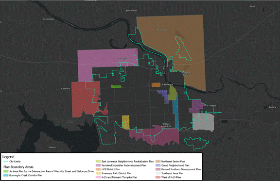
Figure 1: Lawrence - Douglas Co. Sector Plan Boundaries
Generally, the purpose of these land use plans is to provide guidance of land uses, development, and to ensure that proposals and land use changes are in accordance with the community’s long-term vision. These plans also provide implementation recommendations and ensures coordination of development, both public and private, providing a framework to guide an area’s development efforts. Importantly, these plans also provide information regarding the area’s needs, priorities, and proposed projects and shares the vision for an area’s residents, property owners, and local government entities.
Many of the plans will also include recommendations and prescriptions for possible future land uses in these areas. A future land use map is the community’s guide for future zoning and development. Essentially, it expresses how the community wants to grow, but does not serve as a prediction. Within the land use plans, each plan and future land use will recommend one or more base zoning districts that embody the vision and goals presented in that particular plan.
Overall, many of the various land use plans are a part of and governed by the overarching policies of Horizon 2020, the comprehensive plan for the City of Lawrence and unincorporated Douglas County. The more specific, detailed land use plans, then provide a more localized and detailed analysis of these areas’ needs, issues, and development trends. Those plans can cover a variety of topics and land areas, such as specific corridors, neighborhoods, or larger areas on the fringe of Lawrence.
These specific land use plans are incorporated by reference into Chapter 14: Specific Plans of Horizon 2020. This chapter includes:
1. Horizon 2020 / Plan 2040
Plan Overview
2. An Area Plan for the Intersection Area of West 6th Street and Wakarusa Drive
Plan Overview
3. Burroughs Creek Corridor Plan
Plan Overview
4. East Lawrence Neighborhood Revitalization Plan
Plan Overview
5. Farmland Industries Redevelopment Plan
Plan Overview
Plan Overview
7. Inverness Park District Plan
Plan Overview
8. K-10 & Farmer’s Turnpike Plan
Plan Overview
9. Northeast Sector Plan
Plan Overview
Plan Overview
11. Revised Southern Development Plan
Plan Overview
Plan Overview
Plan Overview