|
PLANNING COMMISSION REPORT Regular Agenda – Public Hearing Item |
|
PC Staff Report 05/27/19 |
|
ITEM NO. 14C SPECIAL USE PERMIT FOR LAWRENCE POLICE HEADQUARTERS; 5100 OVERLAND DR (BJP)
SUP-19-00071: Consider a special use permit/institutional development plan for Lawrence Police Headquarters, located at 5100 Overland Drive. Submitted by Hoefer Wysocki on behalf of the City of Lawrence, property owner of record.
|
|
STAFF RECOMMENDATION: Staff recommends approval of a special use permit for the City of Lawrence Police Headquarters, a Public Safety use, located at 5100 Overland Drive based upon the findings presented in the body of the staff report. |
|
Applicant’s Reason for Request: |
Required for use of property as public safety campus. |
KEY POINTS
· This property is proposed to be rezoned to the GPI (General Public & Institutional) District and contains more than 10 acres. Therefore, approval is required through a special use permit per Section 20-1307 of the Development Code.
· This site plan shows both Lots 1 and 2 of the proposed subdivision, PP-19-00034 (Item No. 14B on this agenda). The proposed improvements will be located on Lot 1. Lot 2 will be developed as a city park in the future.
ASSOCIATED CASES
· PP-19-00034: Consider a preliminary plat for Lawrence Police Headquarters, 2 lots and 2 tracts, located at 5100 Overland Drive. Submitted by Hoefer Wysocki on behalf of the City of Lawrence, property owner of record.
· Z-19-00036: Consider a request to rezone approximately 21.254 acres from OS (Open Space) District to GPI (General Public and Institutional) District, located at 5100 Overland Drive. Submitted by Hoefer Wysocki on behalf of the City of Lawrence, property owner of record.
OTHER ACTION REQUIRED
· Planning Commission approval of preliminary plat, PP-19-00034.
· Planning Commission consideration of rezoning request, Z-19-00036.
· City Commission approval of rezoning request and adoption/publication of ordinance.
· City Commission approval of the special use permit and adoption/publication of ordinance.
· Administrative approval of a final plat.
· The approved final plat must be recorded with the Douglas County Register of Deeds Office prior to release of the special use permit for issuance of a building permit.
· Submittal and approval of public improvement plans by city staff prior to issuance of a building permit.
· Release of special use permit site plan to Development Services for building permits.
ATTACHMENTS
1. Special Use Permit/Institutional Development Plan
2. Traffic Study
3. Downstream Sanitary Sewer Analysis
4. Drainage Study
5. Parking Study
PLANS AND STUDIES REQUIRED
· Traffic Study – The 7 step traffic impact analysis dated January 21, 2019 was approved.
· Downstream Sanitary Sewer Analysis – The sanitary sewer study dated January 21, 2019 was approved.
· Drainage Study – The drainage study dated January 16, 2019 was approved.
· Retail Market Study – Not required for this project.
PUBLIC COMMENT
· No public comment was received prior to the printing of this staff report.
GENERAL INFORMATION
|
Current Zoning and Land Use: |
OS (Open Space) District; vacant. |
|
Surrounding Zoning and Land Use: |
To the north: OS (Open Space) District; vacant.
To the south: RM15 (Multi-Dwelling Residential) District; Multi-Dwelling Structure.
OS (Open Space) District; drainage easement.
PCD-[6Wak] (Planned Commercial Development) District; Retail Sales, General (Wal-Mart).
CO (Office Commercial) District; Health Care Office, Health Care Clinic.
To the east: GPI (General Public and Institutional Use) District; School (Free State High School).
To the west: PRD (Planned Residential Development) District; Multi-Dwelling Structure. |
Summary of Special Use
This special use permit facilitates the development of the City of Lawrence police headquarters at 5100 Overland Drive. Concurrent applications were submitted to plat the property into 2 lots and 2 tracts, and to rezone the future police facility property from OS to GPI District. This special use permit staff report assumes approval of the preliminary plat and the rezoning requests.
The purpose of the GPI District is to accommodate institutional uses, such as the proposed Public Safety use, that occupy a large land area as a means to ensure compatibility with the surrounding area. Developments within the GPI District are subject to a requirement to provide an institutional development plan for all property contained in the district. When sites are over 10 acres in size, the institutional development plan is reviewed through the special use permit process to provide public review of the proposed uses and site layout.
Section 20-1307 states the purpose of the institutional development plan (IDP) is “to provide a community vision for the long-term use and development of public institutional space and lands so that they are designed to be compatible with surrounding land uses and contribute to the neighborhood and character of the area in which they are located. Providing this community vision for institutional buildings and sites also allows adjacent and nearby property owners to anticipate future non-residential development patterns and plan for the use and enjoyment of their property accordingly.”
Section 20-1307(c) of the Land Development Code also provides standards for institutional site development as a means to ensure long-term compatibility of use, consistency with the character of the area, and to minimize negative impacts on the surrounding area. A review of the projects compliance with these standards is provided later in this report.
As shown on this institutional development plan, Lot 1 includes a proposed two-story police headquarters facility, a one-story vehicle storage facility, and off-street parking. Lot 2 will include a future city park. The plan also includes 2 open space tracts provided with the intent of preserving the existing natural vegetation and providing a landscape bufferyard. A proposed trail is also shown in Tract A which will provide access from the public sidewalk on Overland Drive to the future city park.
Review and Decision-Making Criteria (20-1306(i))
1. WHETHER THE PROPOSED USE COMPLIES WITH ALL APPLICABLE PROVISIONS OF THIS DEVELOPMENT CODE
Applicant’s Response: Yes.
This section of the staff report assesses the impact and compliance of the improvements associated with the proposed City of Lawrence police headquarters facility with the Land Development Code.
A. Site Summary
|
LOT 1 |
Existing |
Proposed |
Change |
|
Land Area (square feet): |
925,841 |
925,841 |
0 |
|
Total Building (square feet) |
0 |
32,873 |
32,873 |
|
Total Impervious Area (square feet): % Impervious |
6,705 1% |
142,361 15% |
135,656 14% |
|
Total Pervious Area (square feet): % Pervious |
919,136 99% |
783,780 85% |
-135,356 -14% |
The setbacks in the GPI District are as follows: Front—40 feet; abutting R Districts—40 feet; abutting non-R Districts—40 feet. The site plan shows that the location of the proposed City of Lawrence police headquarters facility and vehicle storage building will exceed the setback requirements. The vehicle storage building, which is located closer to the west property line than that police headquarters facility, will be located 82.65 feet from the west property line. The police headquarters facility will be located 171.6 feet from the south property line, and 86.61 feet from the east property line.
B. Access and Parking
One entrance drive exists which provides access from Overland Drive, a collector street. This drive will provide the main access to the City of Lawrence police headquarters facility. A second access from Overland Drive will be constructed to the east of the existing drive. The plan also shows a proposed future access provided from Wakarusa Drive, a principal arterial, further to the north. The existing and proposed ingress and egress, and the vehicle circulation within the site, will provide for safe, efficient and convenient movement and will comply with access management standards.
There is a public sidewalk along the south side of Overland Drive and the east side of Wakarusa Drive. A shared use path exists immediately adjacent to the site on the north side of Overland Drive and the west side of Wakarusa Drive. There will also a pedestrian connection from the shared use path along Overland Drive to the building entrance. The plan also shows trails in Tract A to provide a pedestrian connection from Overland Drive to the future city park.
The parking requirement for the Public Safety use is per Section 20-905, Schedule D. The Land Development Code states that, “Schedule D uses have a widely varying parking demand characteristics making it difficult to specify a single off-street parking standard.” As such, the off-street parking requirement for Schedule D uses is determined by the Planning Director based on a parking study prepared by the applicant. The parking study indicated that 126 parking spaces are needed to accommodate patrol staff, patrol vehicle parking, and full-time employees. The study also recommended 11 additional spaces to accommodate future growth. In addition, the study recommends 19 parking spaces for public parking. The parking study, dated March 6, 2019, was approved by the Planning Director. A breakdown of the parking requirements is provided below.
- Vehicle parking provided: 157 spaces
- Accessible parking spaces require/provided: 6 spaces required/7 spaces provided
- Bicycle parking: Not required for the Public Safety use.
C. Design Standards
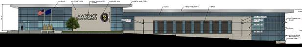
The proposed City of Lawrence police headquarters facility is a two-story building with a façade comprised of large window expanses, and a mix of materials providing both vertical and horizontal variation. The building is not subject to the Community Design Manual for commercial or industrial design standards.
|
|
|
Figure 1. South elevations of the proposed City of Lawrence Police Headquarters. |
D. Landscaping and Screening
Street Trees
Lot 1 is adjacent to Overland Drive and requires 1 shade tree per 40 feet of street frontage. As shown in the table below, the street tree requirement per Section 20-1002 is met.
|
Street |
Requirement |
Required |
Provided |
|
Overland Drive |
1 shade tree per 40 feet of street frontage |
680 feet / 40 = 17 Trees |
17 |
Interior Parking Lot Landscaping
As shown in the calculations below, the interior landscaping requirements per Section 20-1003 are met.
|
|
Required |
Provided |
|
157 parking spaces |
Landscaping Area: 157 stalls X 40 square feet = 6,280 square feet |
11,883 square feet |
|
Trees: 157 stalls / 10 = 16 X 1 = 16 trees |
16 trees |
|
|
Shrubs: 157 stalls / 10 = 16 X 3 = 48 shrubs |
93 shrubs |
Perimeter Parking Lot Landscaping
Per Section 20-1004 of the Land Development Code, parking lots shall be landscaped and screened from view of street rights-of-way with a minimum of one shade or ornamental tree per 25 linear feet of parking lot frontage. In addition to trees, the screening must also include either a solid masonry wall, a berm, or a continuous row of shrubs. The required street trees may be counted toward this requirement. The number of street trees provided meets the perimeter parking lot landscaping requirement.
The site plan proposes a parking area adjacent to Overland Drive. The site plan shows perimeter parking lot landscaping for this area provided by a 2 to 3 foot tall berm, existing vegetation, and the proposed street trees.
Bufferyard Requirements
Section 20-1307(c)(2)(i)(a) requires a bufferyard for institutional site development. As discussed earlier in this report, the proposed City of Lawrence police headquarters facility and vehicle storage building are shown located on the plan in areas that greatly exceed the setback requirements. In addition, a concurrent preliminary plat application proposes creating two adjacent open space tracts. The intent of the tracts is to preserve the existing natural vegetation in the area and provide a buffer between the adjacent uses. A note on the plan indicates that if the trees within these tracts are destroyed or damaged they must be replaced by native species on a 1:1 basis.
Mechanical Equipment
The site plan includes a note indicating that exterior ground-mounted or building mounted equipment will be screened from view of the adjacent properties and street right-of-way.
E. Lighting
A point-by-point photometric plan for the development was provided. The lighting levels are compliant with the standards in Section 20-1103(d)(3). Section 20-1307(c)(2)(vi) indicates that exterior lighting may be prohibited between the hours of 10:00 P.M. and 7:00 A.M.; however, the Planning Director determined that given the nature of the use, and that the development accommodates 24-hour shifts, it is not appropriate to prohibit exterior lighting at night. The photometric plan shows that lighting will not be visible at the property lines, with the exception of lighting provided at the access drives on Overland Drive. At these locations, the maximum measured spillover lighting is 1 foot-candle, which is less than the 3 foot-candle measurement permitted to spillover into public street right-of-way.
F. Floodplain
The property is not located within the regulatory floodplain and is not subject to a local floodplain development permit.
Staff Finding –The use complies with the applicable provisions of the Land Development Code.
2. WHETHER THE PROPOSED USE IS COMPATIBLE WITH ADJACENT USES IN TERMS OF SCALE, SITE DESIGN, AND OPERATING CHARACTERISTICS, INCLUDING HOURS OF OPERATION, TRAFFIC GENERATION, LIGHTING, NOISE, ODOR, DUST AND OTHER EXTERNAL IMPACTS
Applicant’s Response: Yes.
The proposed City of Lawrence police headquarters facility will be located on a large parcel, with adequate buffering and distance from adjoining uses. The proposed development is also appropriately scaled for its size and use. Section 20-1307(c) provides standards for institutional site development to ensure long-term compatibility of use, consistency with the character of the area, and to minimize negative impacts from the institutional development on the surrounding area. As discussed previously, one standard requires bufferyards. The open space tracts proposed to the east and west of the police headquarters facility will provide screening to the adjacent properties. In addition, the proposed police headquarters facility and vehicle storage building will both greatly exceed their required 40 foot setback. The increased setbacks and open space tracts will provide an adequate buffer to mitigate potential impacts to the surrounding area.
The proposed development meets the other standards applicable to an institutional site development, which are listed below. Staff response is provided in italics.
- Access, planned for entire site with at least two points of access
Two access points will be provided from Overland Drive. A future access point is proposed from Wakarusa Drive.
- Public sidewalks, provided along all street frontages
Pedestrian facilities are located on both sides of the adjacent streets. Overland Drive contains a sidewalk on the south side and a shared use path on the north side. Wakarusa Drive contains a sidewalk on the east side and a shared use path on the west.
- Bicycle lanes and recreation paths be planned and provided as part of the plan
The north side of Overland Drive and the west side of Wakarusa Drive contain an existing shared use path. A recreation path is also planned for Tract A which will provide a connection from Overland Drive to the future city park.
- Sports fields and large traffic generation activities be located away from RS zoned area
The subject property is not adjacent to RS zoned areas.
- Exterior lighting may be prohibited between 10:00 P.M. and 7:00 A.M.
Planning Director determined that given the nature of the use, and that the development accommodates 24-hour shifts, it is not appropriate to prohibit exterior lighting at night. The photometric plan shows that lighting will not be visible at the property lines, with the exception of lighting provided at the access drives on Overland Drive. At these locations, the maximum measured spillover lighting is 1 foot-candle, which is less than the 3 foot-candle measurement permitted to spillover into public street right-of-way
- Parking facilities, designed to be shared among uses and incorporated with environmentally sensitive lands.
The plan includes 2 open space tracts provided with the intent of preserving the existing natural vegetation, stands of mature trees, and a natural drainageway.
- Bus stops shall be included in the planning and development of the site
An existing bus route is located along Overland Drive, with a bus stop near the intersection of Overland Drive and Wakarusa Drive.
Staff Finding – The proposed use is compatible with the adjacent uses in terms of size, massing, orientation, hours of operation, and other external impacts.
3. WHETHER THE PROPOSED USE WILL CAUSE SUBSTANTIAL DIMINUTION IN VALUE OF OTHER PROPERTY IN THE NEIGHBORHOOD IN WHICH IT IS TO BE LOCATED
Applicant’s Response: No.
The proposed City of Lawrence police headquarters facility will enhance a community-wide service. The location allows the facility to be easily accessed and will provide increased investment to the community.
Staff Finding – Substantial diminution of other property values in the area is not anticipated.
4. WHETHER PUBLIC SAFETY, TRANSPORTATION AND UTLITY FACILITIES AND SERVICES WILL BE AVAILABLE TO SERVE THE SUBJECT PROPERTY WHILE MAINTAINING SUFFICIENT LEVELS OF SERVICE FOR EXISTING DEVELOPMENT
The Lawrence police headquarters, a Public Safety use, will serve the community. This property is located within city limits and is adjacent to Overland Drive, a collector street, and Wakarusa Drive, an arterial street. Public infrastructure, such as water, sanitary sewer, and stormwater mains, is available to provide service to this development.
Staff Finding – Sufficient safety, transportation and utility facilities will be available to serve the subject property.
5. WHETHER ADEQUATE ASSURANCES OF CONTINUING MAINTENANCE HAVE BEEN PROVIDED
The proposed development will be owned and operated by the City of Lawrence. City staff is responsible for continuing site maintenance. The special use permit provides the overall scope for the development. The proposed request provides an enforceable tool to address the use and continued maintenance. If approved, the institutional development plan will be recorded with the Douglas County Register of Deeds office as a public record of the improvements for the site.
Staff Finding – Adequate assurances of continued maintenance are inherent in the use and the special use permit/institutional development plan approval process.
6. WHETHER THE USE WILL CAUSE SIGNIFICANT ADVERSE IMPACTS ON THE NATURAL ENVIRONMENT
Applicant’s Response: No. The existing drainage way and a significant amount of the existing tree growth will be preserved. Outdoor lighting will be selected to minimize impacts to the surrounding natural environment.
The corresponding preliminary plat, PP-19-00034, shows two open space tracts to be located to the west and east of the subject property. The intent of the tracts is to retain the existing vegetation and to utilize it for screening and buffering purposes.
There is no designated regulatory floodplain that encumbers the property.
Staff Finding – The proposed use should not cause significant adverse impacts on the natural environment.
7. WHETHER IT IS APPROPRIATE TO PLACE A TIME LIMIT ON THE PERIOD OF TIME THE PROPOSED USE IS TO BE ALLOWED BY SPECIAL USE PERMIT AND, IF SO WHAT THAT TIME PERIOD SHOULD BE.
Time limits are established on special use permits to permit a periodic review to determine if the use remains compliant with the area or if a rezoning would be appropriate. This special use permit review process is required because the property proposed to be rezoned to the GPI District exceeds 10 acres. The institutional development plan serves as the master plan for this facility and provides the public with a long-range view of the site development. It would not be appropriate to place a time limit on this use.
Staff Finding – The special use permit process is required by the Land Development Code due to the size and zoning of the property. It would not be appropriate to place a time limit on this use.
Conclusion
As planned, the use is compatible with this location. Based on the findings in this report, staff recommends approval of the special use permit.