ORDINANCE NO. 9507
AN ORDINANCE OF THE CITY OF LAWRENCE, KANSAS, AMENDING CHAPTER 20, ARTICLE 11, SECTIONS 20-1101, 20-1103, 20-1105, AND 20-1108, OF THE CODE OF THE CITY OF LAWRENCE, KANSAS, 2018 EDITION AND AMENDMENTS THERETO, PERTAINING TO GENERAL DEVELOPMENT STANDARDS, AND REPEALING EXISTING SECTIONS 20-1101, 20-1103, 20-1105, AND 20-1108.
BE IT ORDAINED BY THE GOVERNING BODY OF THE CITY OF LAWRENCE, KANSAS:
SECTION 1. Chapter 20, Article 11, Section 20-1101, of the Code of the City of Lawrence, Kansas 2018 Edition and amendments thereto, is hereby amended to read as follows:
20-1101 PROTECTION STANDARDS FOR RESIDENTIAL DISTRICTS
(a) Design and Operational Compatibility Standards—Discretionary Approvals
as a condition of approval of any Special Use Permit, Map Amendment, site plan or other discretionary approval of any multi-Family use or nonresidential use located within 500 feet of any less intensive residential district, the City Commission, Planning Director, Planning Commission or other review body may impose conditions that exceed the minimum requirements of this Chapter and that, in the opinion of the review body, are necessary to reduce or minimize any potentially adverse impacts on residential property, including, but not necessarily limited to, the following:
(1) location on a site of activities that generate potential adverse impacts on adjacent uses, such as noises and glare;
(2) placement and buffering of trash receptacles;
(3) location of loading and delivery areas;
(4) lighting location, intensity, and hours of illumination;
(5) placement and illumination of outdoor vending machines, telephones, and similar outdoor services and activities;
(6) additional Landscaping and buffering;
(7) Height restrictions to preserve light and privacy and views of significant features as viewed from public property and rights-of-way;
(8) preservation of natural lighting and solar Access;
(9) ventilation and control of odors and fumes; and
(10) paving or other surface treatment for dust control.
(b) Height Limit on Projects Adjoining Certain Residential Zoning Districts
See Section 20-701(g) for Height limits in the PD district.
(c) Balconies of a multi-Dwelling Unit Building
Balconies above the second Story of a multi-Dwelling Unit Building are prohibited along the exterior of a RM development unless the Building Setback is increased to at least double the required minimum Setback and Landscaping is enhanced with two or more of the following features: a minimum 4’ Berm, a solid Screening fence (6’ minimum height) or a masonry wall (6’ minimum height). This provision shall apply only to those exterior sides of a Planned Development that are adjacent to RS zoning or to detached Dwelling Units.
(d) Standards for Environmentally Sensitive Lands
(1) Applicability
The provisions of this Article regarding environmental protection for sensitive lands shall apply to all construction and development in all RS and RM Districts, with the exception of individually platted lots for single or duplex dwellings which were platted prior to (the effective date of this Text Amendment).
(2) Environmentally Sensitive Lands
(i) Protected Areas.
If 500 sq ft or more of a proposed development consists of lands falling in the following categories, any proposed development may proceed only in accordance with the processes allowed by this section. The lands affected by this section are listed below in a priority order for protection:
Regulatory Floodways, designated on the FEMA Flood Insurance Rate Map for Douglas County and identified on the City GIS Baseline Environmentally Sensitive Areas Map;
a. Regulatory Floodway Fringe, designated on the FEMA Flood Insurance Rate Map for Douglas County based on 100 year storm and identified on the City GIS Baseline Environmentally Sensitive Areas Map;
b. Jurisdictional Wetlands, as determined by the Army Corps of Engineers;
c. Stream Corridors as defined in this Code and identified on the City GIS Baseline Environmentally Sensitive Areas Map;
d. Stands of Mature Trees as defined in this Code and identified on the City GIS Baseline Environmentally Sensitive Areas Map; and
e. Archaeological and Historic Sites listed on local, state, or federal registers.
(ii) Determination of Development Land Area
In determining whether a portion of a proposed development consists of sensitive lands, all contiguous lands under the same Ownership or control shall be considered. Lands owned or controlled by a partnership, trust or corporation under the same effective control shall be considered, along with lands owned directly by the applicant and lands under option to the applicant or a partnership, trust or corporation under the effective control of the applicant.
(3) Procedures to be Followed
(i) Platted Lots -- Amount Required
For all types of developments, required protection of environmentally sensitive lands shall be limited to a maximum protection area of 20% of the total land area. The protected environmentally sensitive lands shall be set aside as private Common Open Space or dedicated to the City as parkland or open space. Incentives for protection of environmentally sensitive lands in amounts above 20% of the total land area are included in Section 20-1101(f).
(ii) Development Process
Development on land which contains more than 500 square feet of sensitive lands shall require submission of a Sensitive Areas Site Plan [see Section 20-1101(f)], and may proceed through one of the following processes:
a. Site Planning. Development on properties containing more than 500 square feet of environmentally sensitive lands shall require submission of a Sensitive Areas Site Plan [see Section 20-1101(f)], which may be consolidated with any other required site plan submitted, but will be, in any event, required prior to approval of a development proposal. The plan shall clearly delineate the environmentally sensitive lands to be protected and shall include information regarding protection measures and maintenance.
b. Platting. Environmentally sensitive lands to be protected shall be located within tracts and/or easements. Information regarding ownership and maintenance responsibility of the tract or easement, as well as protection measures, shall be included on the preliminary and final plat.
c. Planned Development. Development standards in Section 20-701 apply. Environmentally sensitive lands to be protected shall be included within the Common Open Space.
d. Cluster Housing Project. Development standards in Section 20-702 apply. Environmentally sensitive lands to be protected shall be included within the Common Open Space.
(4) Effect on Development Density
Where the types of lands listed in Section 201101(d)(2)(i) are included in a proposed development, that land may be included in determining the allowable Density or intensity of development and the allowable density, calculated on the total land area, may be transferred to other developable portions of the property
(e) Density Bonus Incentives for Protection of Additional Lands
Density bonuses are available to encourage the protection of environmentally sensitive lands in a greater amount than required.
(1) Applicability
A development shall qualify for a density bonus if environmentally sensitive lands noted in this Section are committed for preservation either through designation as a tract, through a conservation or landscape easement, or dedication to the City in addition to the area required in Section 20-1101(d)(3)(a) with the following exceptions or additions:
(i) The density bonus incentives do not apply to the protection of regulatory floodway above the amount required in this Section.
(ii) Slopes of 25% or greater may be included in the environmentally sensitive lands for the density bonus incentives, provided the required area being protected with features listed in Section 20-1101(d)(2)(i) equals or exceeds 20% of the total developable area.
(iii) Native prairie remnants may be included in the environmentally sensitive lands for the purpose of these incentives. The protection of any amount of native prairie remnant qualifies for the density bonus incentives, regardless of what amounts of other environmentally sensitive lands have been protected. If native prairie remnants are protected, the density bonus is calculated per Table 1 and 2 in Section 20-1101(e) as if the 20% of developable area has been protected.
(2) Approval Criteria
(i) In addition to these regulations, development on properties with certain environmentally sensitive lands, such as jurisdictional wetlands, may be restricted by state or federal regulations.
(ii) In order for a density bonus to be approved, City planning staff must determine that utilities and infrastructure are available to serve the additional density proposed and the design of the development does not negatively impact adjacent properties.
(iii) Land offered for dedication shall be subject to approval by the Governing Body.
(3) Density Bonus – Increase in Number of Dwelling Units
(i) Determination of Base Density
The Base Density, the number of dwelling units which can be developed on a property, will be determined from a ‘concept plat’ or sketch plan provided by the applicant which shows the basic street layout and rights-of-way, the areas necessary for stormwater detention (based on an approved conceptual drainage study), the 20% of the site which is being protected with environmentally sensitive lands, and proposed lot layout in conformance with density and dimensional standards in Section 20-601.
(ii) Determination of Density Bonus
If the density bonus meets the criteria noted in Section 20-1101(e)(1), the density bonus to be applied to the base density shall be calculated using the proportions in Table 1.
a. The density may exceed the Density Cap in multi-dwelling districts.
b. The density may equal but may not exceed the Density Cap for single-family and duplex districts.
c. Density Caps set by the Comprehensive Plan are noted in Table 2.
|
20-1101(e) TABLE 1 Density Bonus—Increase in number of dwelling units |
||||
|
% of property that is protected |
% increase in Dwelling Units |
|
% of property that is protected |
% increase in Dwelling Units |
|
21 |
1 |
31 |
11 |
|
|
22 |
2 |
32 |
12 |
|
|
23 |
3 |
33 |
13 |
|
|
24 |
4 |
34 |
14 |
|
|
25 |
5 |
35 |
15 |
|
|
26 |
6 |
36 |
16 |
|
|
27 |
7 |
37 |
17 |
|
|
28 |
8 |
38 |
18 |
|
|
29 |
9 |
39 |
19 |
|
|
30 |
10 |
40 |
20 |
|
|
20-1101(e) TABLE 2 Density Cap per Zoning District |
|||
|
Comprehensive Plan Designation |
Density Cap Horizon 2020 (du/acre) |
Zoning District |
Max. Density per Code (du/acre) |
|
Very-low density: single dwelling |
1 |
RS40 |
1.09 |
|
Low-density: single dwelling |
2-6 |
RS20 |
2.18 |
|
RS10 |
4.26 |
||
|
RS7 |
6.22 |
||
|
Medium density: single dwelling |
7-15 |
RS5 |
8.7 |
|
RS3 |
14.52 |
||
|
RSO |
14.52 |
||
|
Medium density: multi dwelling |
7-15
|
RM12, |
12 |
|
RM12D, |
12 |
||
|
RM15 |
15 |
||
|
High-density: multi-dwelling |
16-21 du / acre |
RM24, |
24 du / acre |
|
|
RM32 |
32 du / acre |
|
(iii) Standards Adjustment
a. In single-dwelling and duplex-dwelling zoning districts, it may be necessary to reduce the lot area and/or lot width requirements to permit the allowable density. These modifications may be made to the minimum degree necessary to accommodate the allowable density.
b. In multi-dwelling districts, it may be necessary to increase the height limitation, in addition to adjustments to the lot area and/or lot width requirements, to permit the allowable density. These modifications may be made to the minimum degree necessary to accommodate the allowable density.
(4) Density Bonus - Increase in Developable Square Footage
This bonus permits the construction of larger structures, and/or the addition of more impervious surface on a lot, rather than an increase in the number of dwelling units. The proportions listed in Table 3 apply to the increase in developable square footage. Each 1% of protected environmentally sensitive lands protected above that required by Code results in a 1% increase in the building or impervious surface coverage up to a maximum of 40%. (In no case shall the building coverage or impervious surface coverage exceed 90% of the lot).
|
20-1101(e)-TABLE 3 Density Bonus — Increase in Developable Area |
||||||
|
Zoning District |
Maximum Building Coverage (%) |
Maximum Impervious Coverage (%) |
Min Outdoor Area per Dwelling (sq ft) |
Int Side Setback (ft) |
Front Setback (ft) |
Rear setback (ft) Single frontage / double frontage |
|
RS40 |
15 |
25 |
-- |
20 |
25 |
30/35 |
|
RS20 |
30 |
50 |
-- |
20 |
25 |
30/35 |
|
RS10 |
40 |
70 |
-- |
10 |
25 |
30/25 |
|
RS7 |
45 |
70 |
-- |
5 |
25 |
30/25 |
|
RS5 |
50 |
75 |
240 |
5 |
20 |
20/25 |
|
RS3 |
50 |
75 |
150 |
5 |
15 |
20/25 |
|
RSO |
50 |
75 |
-- |
5 |
25 |
20/25 |
|
RM12D |
50 |
75 |
50 |
5 |
25 |
20/25 |
|
RM12 |
50 |
75 |
50 |
5 |
25 |
20/25 |
|
RMO |
50 |
75 |
50 |
5 |
25 |
20/25 |
|
RM15 |
50 |
75 |
50 |
5 |
25 |
25/25 |
|
RM24 |
50 |
75 |
50 |
5 |
25 |
20/25 |
|
RM32 |
60 |
80 |
50 |
5 |
25 |
20/25 |
|
* |
1% increase
|
1% increase
|
1% decrease
|
Adjusted as needed --not less than 5 |
Adjust as needed—not less than 15 |
Adjust as needed—not less than 15 |
(i) Standards Adjustment
In some cases the minimum outdoor area or setbacks may need to be reduced to accommodate the additional building or impervious surface coverage. This reduction may be made to the minimum degree necessary to accommodate the additional building or impervious surface coverage.
(f) Sensitive Areas Site Plan Required
Prior to development on land containing more than 500 square feet of environmentally sensitive lands listed in Section 20-1101(d)(2)(i) a Sensitive Areas Site Plan shall first be submitted to and approved by the City in accordance with the requirements of Site Plan Review, Section 20-1305 including the public notice procedures of Section 20-1305(g).
(1) Sensitive Areas Site Plan Contents
The Sensitive Areas Site Plan must be prepared in accordance with the requirements in Section 20-1305(f) with the exception that a Sensitive Areas Site Plan is not required to be completed by an engineer, architect or other qualified professional. In addition to the contents noted in Section 20-1305(f), the site plan shall:
(i) Clearly delineate the property boundaries.
(ii) Clearly delineate the boundaries of the environmentally sensitive lands listed in Section 20-1101(d)(2)(i).
(iii) Designate protected lands per the priority order in Section 20-1101(d)(2)(i).
(iv) Provide information on the ownership and maintenance responsibility for the protected lands.
(v) Provide information on the methods to be used to protect environmentally sensitive lands, both during construction and after.
(g) Drainage Easements
All express drainage Easements dedicated,
purchased or otherwise granted to the City in writing are governed by the
standards of this section. No person may construct, maintain, or allow any
natural or non-natural Structures or vegetative barriers (including but not
limited to trees, Shrubbery, Berms, fences, and walls) upon drainage Easements
that the Director of Public Works the Municipal Services and
Operations Department finds impedes, detains, retains, or otherwise
interferes with the drainage of stormwater regardless of the source of
stormwater.
(h) Administration and Enforcement of Drainage Easements
The Director of Public Works the
Municipal Services and Operations Department may enter upon the drainage
Easement, at any time and without notice, to inspect the drainage Easement.
(1) If
the Director of Public Works the Municipal Services and Operations
Department finds that any natural or non-natural Structure or vegetative
barrier impedes, detains, retains, or otherwise interferes with the drainage of
stormwater, the Director of Public Works the Municipal Services and
Operations Department shall issue a notice to the Landowner to abate that
condition within 30 days or such longer time period as the Director of Public
Works the Municipal Services and Operations Department deems appropriate.
Within 14 days of the mailing of the notice to abate, the Landowner may request
a hearing before the City Commission. If the Landowner requests a hearing, the
City Commission shall determine the appropriateness of the order to abate, make
findings as are appropriate, and order any necessary action as appropriate. The
time period set by the Director of Public Works the Municipal
Services and Operations Department to abate the nuisance shall be stayed
from the date the notice is filed until the City Commission has acted on the appeal.
If the abatement is not completed within the time frame allowed by the notice
to abate, including the period of time a stay is in effect, if any, or by the
direction of the City Commission, the Director of Public Works the Municipal
Services and Operations Department will proceed with the abatement action.
Pursuant to K.S.A. 12-6a17, the Director of Public Works the Municipal
Services and Operations Department shall order collection of the cost of this
abatement upon the Landowner.
(2) This section does not create liability upon the City or its employees regarding the creation, dedication, inspection and maintenance of drainage Easements.
SECTION 2. Chapter 20, Article 11, Section 20-1103, of the Code of the City of Lawrence, Kansas 2018 Edition and amendments thereto, is hereby amended to read as follows:
20-1103 OUTDOOR LIGHTING
(a) Purpose
The outdoor lighting standards of this section are intended to eliminate spillover light and light glare on motor vehicle operators, pedestrians, and land uses near light sources. Safety considerations are a primary basis for the regulations, especially pedestrian, motor vehicle and traffic safety. In other cases, the regulations are intended to protect property values and the general welfare by controlling the nuisance aspects of glare or spillover light.
(b) Applicability
The regulations of this section apply to all uses except:
(1) Public
Street lights, which are exempt from the standards of this section but are
subject to all applicable standards of the Kansas Department of Transportation
and the City of Lawrence Public Works Municipal Services and
Operations Department;
(2) residential uses, which are exempt from the outdoor lighting standards of this section except that spot lights or flood lights that create a glare on neighboring property are prohibited. Off-Street Parking Lots associated with residential uses are not exempt from the outdoor lighting standards of this section;
(3) holiday lighting;
(4) outdoor recreation uses, which are subject only to the standards of Section 20-1103(e); and
(5) Telecommunication Towers and Antennas.
(c) Exterior Lighting (Photometric) Plan
(1) When Required
An outdoor lighting plan shall be submitted to the Planning Director whenever outdoor lighting is to be installed or whenever Site Plan Review is required. The lighting plan shall be reviewed to determine whether the proposed outdoor lighting complies with the standards of this section.
(2) Information Required
Outdoor lighting plans shall include a photometric plan and data on the types of lighting fixtures to be used. The photometric plan includes all of the following unless the Planning Director determines that a thorough review and determination is possible without such information:
(i) Scaled drawing of the site with all outdoor lighting fixture locations identified;
(ii) Fixture specifications, such as catalog cut-sheets. The lighting fixture data shall be based on the photometric plan and shall indicate type of fixture, Height, shielding, luminare type and wattage.
(iii) Lamp type and size.
(iv) A point-by-point illumination array for the major Parking Area or areas. The point-by-point array shall indicate site illumination along the Lot Line at 10-foot intervals and on the interior of the site at 20-foot intervals.
(d) Lighting Standards
(1) Light Confinement
(i) All outdoor lights shall, to the maximum extent feasible, confine emitted light to the property on which the light is located and not be directed upwards toward the sky.
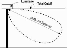
(ii) All fixtures shall be cut-off fixtures that confine lighting to the subject site and shield the light source from view. Cut-off fixtures are not required when the luminaries are less than 150 watt incandescent.
(iii) Under-Canopy or downcast, roof-mounted lights shall be recessed from the lowest point of the ceiling plane and shall not exceed a maximum of thirty (30) Foot-candles.
(2) Visible Light Sources
Outdoor light sources that are visible within the normal range of vision from any R-zoned property are prohibited, unless the luminaries are less than 150 watt incandescent.
(3) Spillover Light
Spillover light is measured at Grade and is regulated as follows:
(i) Spillover light onto R-zoned property may not exceed 0.2 Footcandles, measured at the residential Lot Line.
(ii) Spillover light onto Public Street rights-of-way or properties in a nonresidential Zoning District may not exceed 3 Foot-candles, measured at the Lot Line of the illuminated site.
(iii) When outdoor lighting is used on property that is across the Street from R-zoned property, the maximum illumination at the Lot Line (abutting the Street right-of-way) of the illuminated site may not exceed one Foot-candle.
(e) Special Standards for Outdoor Recreation Uses
Because of their unique requirements for nighttime visibility and their limited hours of operation, outdoor recreation uses are exempt from the preceding outdoor lighting standards of this section. Instead, outdoor recreation uses are subject to the following standards:
(1) Lights at outdoor recreation uses may not exceed a maximum permitted post height of 60 feet.
(2) No flickering or flashing lights are permitted.
(3) Lights may not be illuminated after 11:30 p.m.
(4) As-built lighting and photometric plans are required.
(5) Lighting shall be designed, to the maximum extent feasible, to minimize adverse impacts on traffic safety and nuisance impacts on R-zoned property. Mitigation can be required via extra Landscaping, earlier shutoff times for the lights, cutoff fixtures (where feasible) and other techniques.
SECTION 3. Chapter 20, Article 11, Section 20-1105, of the Code of the City of Lawrence, Kansas 2018 Edition and amendments thereto, is hereby amended to read as follows:
20-1105 SIDEWALKS
(a) Applicability
Sidewalks shall be installed for any
Significant Development Project, provided, that if sidewalks currently exist at
the site, the Landowner will not be required to install new sidewalks at the
site unless the existing sidewalk is recommended for condemnation by the Public
Works Municipal Services and Operations Department pursuant to
K.S.A. 12-1808. Financing of sidewalks shall be in accordance with the City’s
adopted development policy.
(b) Design and Construction Standards
(1) Sidewalks shall be installed according to specifications adopted by the City Commission.
(2) Minimum widths are as follows:
|
Street Type |
Minimum Sidewalk Width (in feet) |
|
Local |
5; Minimum width of 4 feet allowed in Original Townsite Area |
|
Collector |
5 |
|
Arterial |
6; A designated 10’ Bicycle/Recreation Path on one side of the Street and a 6’ sidewalk on the other side |
(3) The City Engineer is authorized to vary minimum sidewalk width and construction standards when the standards would be:
(i) impractical because of topography or site conditions;
(ii) inconsistent with the width of sidewalks on abutting sites; or
(iii) inconsistent with the pattern or material of sidewalks in older neighborhoods or historic districts.
(c) Relationship to Standards under Americans with Disabilities Act where compliance with design standards established in accordance with the Americans with Disabilities Act conflict with design standards set forth in this Article, the standards under the Americans with Disabilities Act will control. Where it is possible to comply with both the design standards under this Article and design standards established under the Americans with Disabilities Act by providing additional facilities or by otherwise modifying the design, then compliance with both sets of standards shall be required.
SECTION 4. Chapter 20, Article 11, Section 20-1108, of the Code of the City of Lawrence, Kansas 2018 Edition and amendments thereto, is hereby amended to read as follows:
20-1108 GENERAL DEVELOPMENT STANDARDS FOR MIXED USE (MU) DISTRICTS
(a) Where Appropriate
The Mixed Use District zoning classification may not be appropriate in all areas of the City of Lawrence. To be eligible for rezoning to the Mixed Use District, a site proposed for Mixed-Use development shall be:
(1) Within one-quarter of a mile of Designated Transit Route at the time the rezoning is initiated; and
(2) Near or adjacent to the intersection of Arterial Streets as per the adopted Major Thoroughfares Map; or
(3) Within one-quarter of a mile of university campuses; or
(4) Within one-quarter of a mile of downtown, the boundaries of which are described in Chapter 6 of Horizon 2020; or
(5) Immediately adjacent to public parks or open space; or
(6) An existing nonresidential development proposed for redevelopment.
(b) Alterations to Designated Transit Routes
The provisions of Section 20-1108(a)(1) shall apply to Mixed Use development in the MU Zoning District. If the Designated Transit Route is altered such that it is no longer within one-quarter of a mile of a Mixed-Use development, then an approved Mixed Use development shall not be made a nonconforming use.
(c) Compatibility
Mixed Use developments shall be compatible with existing development which surrounds the proposed Mixed-Use development. Compatibility is best achieved through a transition in Building form, Scale and intensity, as well as through uses, peripheral buffers or Landscaping. In furtherance of this purpose, development zones shall be designated on the property proposed for the Mixed Use development. Such zones shall be designated to govern the permitted Density, Building Height and Building Scale and to assure compatibility between the proposed development and surrounding existing development.
(d) Applicability
The provisions of this section shall apply to all construction and development in the Mixed Use District, except as expressly exempted in this section.
(1) Any Structure(s) which existed prior to being rezoned to the Mixed Use District may become nonconforming with regard to the Development standards of Section 20-1108. Such Structures, if involuntarily damaged or destroyed may be reconstructed as they existed if and only if a building permit for the restoration is obtained within 12 months of the date of the occurrence of the damage and once issued, construction shall be diligently pursued.
(2) Structures which existed prior to being rezoned to the Mixed Use District shall be allowed to remain as developed until such Structure is proposed to be demolished and redeveloped, improved or modified as a Major Development Project. Improvements or modifications proposed and approved as a Minor or Standard Development Project are required to be compliant with the standards of this section, the Development Code and/or the Commercial Design Standards, unless otherwise determined by the Planning Director.
(3) The intensification of the use in Structures which existed prior to being rezoned to the MU District that increases the off-street parking requirements shall not constitute a Major Development Project.
(4) If a use exists at the time of a zoning map amendment to the MU district, but is regulated as a Special Use upon adoption of the zoning map amendment to the MU District, the use will be considered an approved Special Use and will be allowed to continue without a separate public hearing for the Special Use. Any alterations or expansions of the use are subject to the Special Use amendment procedures of Section 20-1306.
(e) Mixed Use Development
Development in the Mixed Use District shall include a mixture of residential and nonresidential uses together in one Structure or in separate Structures, designed to form a pedestrian-Scale environment.
(f) Development Zones
Development zones govern permitted Density on the site as well as Building Height, Scale and form. The three development zones are hierarchical in terms of development intensity permitted. A proposal to rezone to the MU District need not designate all three development zones. Development zones shall be designated to ensure compatibility with surrounding existing development. In cases where a rezoning to the MU District is proposed for a site which has adjacent RS zoning, a Tertiary Development Zone shall be required to be designated adjacent to such zoning in order to ensure compatibility of Height, Scale, use and form.
(1) Primary Development Zone
The Primary Development Zone is that area of land within a Mixed Use development which is designated for the most intense development allowed by the District. Primary Development Zones shall contain Vertical Mixed Use Structures with a mixture of both residential and nonresidential uses and no interruption of Building Frontage along the Public Frontage. Where a Primary Development Zone fronts upon a Public Frontage, such area shall be designated as Primary Public Frontage. A Primary Public Frontage shall be designed to accommodate heavy pedestrian traffic and ground-level nonresidential uses. Residential uses shall not be permitted on the ground level of Structures in the Primary Development Zone.
(2) Secondary Development Zone
The Secondary Development Zone is that area of land within a Mixed Use development which is designated for less-intense development, relative to that permitted by a Primary Development Zone. Secondary Development Zones may contain Vertical Mixed Use Structures, Horizontal Mixed Use Structures or single-use Structures with interruption of Building Frontage along the Public Frontage allowed only for Access to Parking Areas, for Alleys or service lanes. Where a Secondary Development Zone fronts a Public Frontage such area shall be designated as Secondary Public Frontage. A Secondary Public Frontage shall be designed to accommodate moderate amounts of pedestrian traffic, and if planned, vehicular Access to Parking Areas and service lanes in a manner that minimizes pedestrian-vehicular conflict. Secondary Development Zones may contain both nonresidential ground-level uses as well as ground level residential uses.
(3) Tertiary Development Zone
The Tertiary Development Zone is that area of land within a Mixed Use development which is designated for the least-intense development, relative to that permitted in the other zones per the Density and Dimensional standards of Article 6.
(g) Designation of Development Zones
The applicant for any rezoning to the MU District shall propose development zones for the entire site proposed to be rezoned. The proposed designation shall be included with the application for rezoning. No application for rezoning to the MU District shall be considered complete and sufficient without this information. The proposed designation shall include, at a minimum, the following information:
(1) A plan or graphic representation depicting the location and arrangement of each proposed development zone for the entire site proposed to be rezoned. The plan or graphic shall include the following:
(i) A general location map showing the subject property’s location;
(ii) Existing and proposed Lot lines on the subject property;
(iii) Existing and proposed rights-of-ways of the subject property;
(iv) The existing zoning and land use of the subject property;
(v) The existing zoning and land use of surrounding properties;
(vi) The Height and Floor Area footprint of individual Structures in surrounding existing development;
(vii) The Building form (i.e. Vertical Mixed Use Structure, Horizontal Mixed Use Structure, Attached Structure or Detached Structure) of surrounding existing development;
(viii) A written narrative describing how each development zone proposed is compatible with surrounding existing development in terms of Building Height, Building form, and land use.
(h) Public Frontage Form Standards
In order to ensure the design of pedestrian-oriented Mixed Use developments, each development proposed shall comply with the following standards based upon the applicable Public Frontage. The site plan proposed shall clearly demonstrate that the following Public Frontage form standards are satisfied.
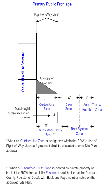
(1) Primary Public Frontages
A Primary Public Frontage shall be planned and designed for all Public Frontages in association with any designated Primary Development Zone. The site plan shall demonstrate that each Primary Public Frontage is planned and designed in accordance with the standards shown below.
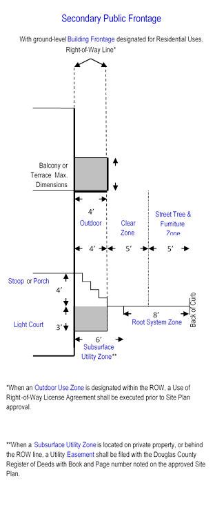
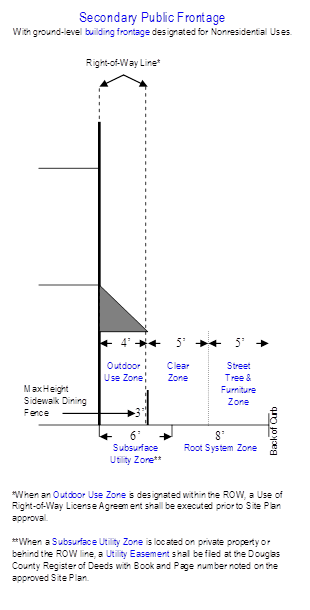
(2) Secondary Public Frontages
A Secondary Public Frontage shall be planned and designed for all Public Frontages in association with any designated Secondary Development Zone. The site plan shall demonstrate that each Secondary Public Frontage is planned and designed in accordance with the standards shown below.
 |
(3) Tertiary Public Frontages
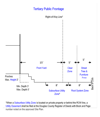
A Tertiary Public Frontage shall be planned and designed for all Public Frontages in association with any designated Tertiary Development Zone. The site plan shall demonstrate that each Tertiary Public Frontage is planned and designed in accordance with the standards shown below.
(4) Deviations
Deviations from these Public Frontage form standards may be granted by the Planning Director during site plan review in the following circumstances:
(i) The
width of the Subsurface Utility Zone and Root System Zone may be altered based
upon a recommendation by the City Utility Municipal Services and
Operations Department and/or Parks and Recreation Department staff in order
to resolve a conflict between placement of trees, Landscaping and utilities;
(ii) The width of the any above-surface zone may be altered by the Planning Director if he/she determines that such alteration promotes pedestrian safety.
(i) Pedestrian and Vehicular Access
In areas designated as the Primary Public Frontage, vehicular Access to individual Lots may be permitted only from a public Alley. In areas designated as Secondary Public Frontage or Tertiary Public Frontage, vehicular Access may be permitted from the Alley or Street. Pedestrian Access shall be permitted from the Street, public Alley or pathway.
(j) Building Form & Use Standards
The following Building forms shall be permitted in the Mixed UseDistrict:
(1) Vertical Mixed Use Structures
Such Structures shall be a minimum of two stories in Height above Grade and shall contain both nonresidential uses and residential uses distributed vertically throughout the Structure.
(i) Where Permitted
New construction of Vertical Mixed Use Structures shall only be permitted in the Primary Development Zone and Secondary Development Zone. Development of existing multi-story buildings as Vertical Mixed Use Structures is permitted in the Tertiary Development Zone. The Density and dimensional standards of Article 6 for each development zone shall apply.
(ii) Nonresidential Uses
Any permitted nonresidential use may be located in a Vertical Mixed Use Structure.
(iii) Location of Nonresidential Uses
The ground-level or street-level of Vertical Mixed Use Structures shall be designed, constructed, and reserved for occupation by nonresidential uses.
(iv) Residential Uses
Non-Ground Floor Dwelling(s) shall be permitted in Vertical Mixed Use Structures. Work/Live Units are permitted when the nonresidential component of the unit occupies the Building Frontage.
(2) Horizontal Mixed Use Structures
Such Structures shall contain a mixture of nonresidential uses and residential uses distributed horizontally throughout the Structure. The location of the uses within as Horizontal Mixed Use Structure shall be as follows.
(i) Where Permitted
Horizontal Mixed Use Structures shall only be permitted in the Secondary Development Zone and the Tertiary Development Zone. The Density and dimensional standards of Article 6 for each development zone shall apply.
(ii) Nonresidential Uses
Any permitted nonresidential use may be located in a Horizontal Mixed Use Structure.
(iii) Location of Nonresidential Uses
The Building Frontage of a Horizontal Mixed Use Structure shall be designed, constructed, and reserved for occupation by nonresidential uses.
(iv) Residential Uses
Attached Dwellings shall be permitted in Horizontal Mixed Use Structures. Live/Work Unit(s) are permitted in Horizontal Mixed Use Structures with direct internal Access between the residential and nonresidential components of the unit, however, the nonresidential component of the unit must occupy the Building Frontage with the residential component of the unit located behind the nonresidential component.
(3) Attached Structures
Such Structures are designed to contain either nonresidential or residential use(s). Such Structures are not designed to contain both residential and nonresidential uses and therefore are not considered to be Mixed Use Structures. Attached Structures may contain a variety of nonresidential uses (such as retail and office) or a variety of residential uses (such as townhomes or rowhomes, i.e. Attached Dwellings).
(i) Where Permitted
Attached Structures shall only be permitted in the Secondary Development Zone and the Tertiary Development Zone. The Density and dimensional standards of Article 6 for each development zone shall apply.
(4) Detached Structures
Such Structures are designed to contain either a single nonresidential or a single residential use. Such Structures are designed to contain a single use.
(i) Where Permitted
Detached Structures shall only be permitted in the Tertiary Development Zone.
(k) Parking Area Standards
The following Automobile and Bicycle Parking provisions apply to all development in the MU District in addition to the provisions of Article 9 not described below. If the provisions of Article 9 conflict or are inconsistent with any of the provisions within this Section, the regulations of this Section shall apply.
(1) Required Automobile Parking
(i) Provision of On-Street Parking
On-Street parking shall be counted toward the minimum off-Street parking requirements for a given use as per Section 20-902. On-Street Parking may be provided on all Streets forming the perimeter boundary of or within a Mixed Use development with the exception of Streets classified as Principal Arterial Streets according to the adopted Major Thoroughfares Map of the City of Lawrence. When a Principal Arterial Street forms the perimeter boundary of, or is contained within a Mixed Use development parking may be designed in the form of a Slip Road as approved by the City Engineer.
(ii) Shared Off-Street Parking
The applicant may elect to use the Shared Parking provisions of Section 20-909 to calculate the required parking for the Mixed Use development. All uses within Mixed Use development, except Detached Dwellings on individual Lots are encouraged to share parking rather than provide parking on a use by use basis on individual properties.
(iii) Location of Off-Street Parking Areas
Parking Areas shall not be permitted in a designated Primary Development Zone. All Parking Areas shall be located within the site area of the Mixed Use development and within 1,320 feet of any use for which it is designated to provide parking. Parking Areas shall be located in accordance with the provisions of Section 20-908(c). (iv) Access to Off-Street Parking Areas Access to a Parking Area shall not be permitted through a designated Primary Public Frontage.
(2) Bicycle Parking Areas
The provisions of Article 9 shall apply.
(l) Development Bonuses
A development bonus is an incentive-based tool that permits an increase in the allowable development potential of a property in exchange for helping the community achieve goals as stated in the Lawrence/Douglas County Comprehensive Land Use Plan. Mixed Use developments in the MU District which contain features it identified as public goals in the table below may be eligible to increase development potential based upon the number of points earned. The applicant shall make a request for development bonus(es) in writing with the site plan application. The request shall state the goal(s) provided, points earned and development bonus redeemed for the points earned. Such information shall also be stated on the approved
site plan.
|
Public Goal |
Points Earned |
|
Goal I: Provision of Moderately-Priced Dwelling Units |
|
|
Percentage of all Dwelling Units which are considered to be Moderately-Priced Dwelling Units |
100 points for the first 10%; PLUS 10 points for each 1% provided in addition to 10% |
|
Goal II: Provision of a variety of housing types |
|
|
At least two (2) of the following five (5) housing types must be provided in order to redeem points. |
|
|
Non-Ground Floor Dwellings |
25 if two (2) of the types are provided; 50 if three (3) of the types are provided; 75 if four (4) of the types are provided; 100 if five (5) of the types are provided; |
|
Attached Dwellings |
|
|
Live/Work Units |
|
|
Assisted Living or Independent Living |
|
|
Zero-Lot Line Dwellings |
|
|
*The points earned for provision of the above-mentioned goals may be combined |
|
|
Goal III: Provision of transit-supportive development |
|
|
Location adjacent to Designated Transit Stop |
100 points if located directly adjacent to a transit stop and if stop is integrated into the Mixed UseDevelopment and transit stop/pedestrian amenities are provided. |
|
Goal IV: Ensuring availability of adequate public facilities |
|
|
Location within ½ mile of a fire station |
10 points |
|
Location within 1 mile of a police station |
10 points |
|
Location within ¼ mile of a public park or open space |
25 points |
|
Location within ¼ mile of a school or cultural center |
25 points |
|
Redevelopment of an existing commercial or nonresidential center with adequate utility and transportation InfraStructure to support redevelopment |
75 points |
|
Location adjacent to the intersection of two streets classified as either Minor Arterial or Principal Arterial according to the adopted Major Thoroughfares Map |
15 points |
|
Goal V: Ensuring Protection of Environmental Quality |
|
|
Provision of a green roof or rooftop garden to control stormwater runoff (determination of materials used to constitute a green roof or rooftop garden shall be made by the City Stormwater Engineer) |
75 points |
|
Provision of a stormwater best management practice as per the adopted BMP Manual |
25 to 50 points (as determined by the City’s Stormwater Engineer) |
|
Construction of a Structure with LEED (Leadership in Energy Efficient Design) Certification |
100 points per mixed-use Structure certified;
|
|
Construction of a residential Structure with ENERGY STAR Certification |
25 points per attached or detached Dwelling certified;
|
|
Protection of Sensitive Land Features as per Section 20-1101(d)(4) otherwise not required to be protected or preserved |
25 points per feature preserved |
|
Protection of Sensitive Land Features as per Section 20-1101(d)(4) otherwise not required to be protected or preserved |
25 points per feature preserved |
(m) Redemption of Development Bonus
(1) Increase in Residential Density
In a designated Primary Development Zone, the maximum residential Density permitted as stated in Section 20-601(c) may be increased at the rate of 1 additional Dwelling Unit per acre for every 10 points earned. For instance, if a development proposal earns 20 points an additional 2 Dwelling Units per acre may be constructed (for a total of 34) in the Primary Development Zone. Points earned in any development zone may be transferred to the Primary Development Zone for redemption.
(2) Increase in Building Height
In a designated Primary Development Zone, Building Height may be increased above the permitted maximum Height as stated in Section 20-601(c) at the rate of 12 feet for every 100 points earned. Points earned in any development zone may be transferred to the Primary Development Zone for redemption.
(3) Increase in Building Coverage Above Maximum
In the Secondary Development Zone, Building coverage may be increased above the maximum permitted as per Section 20-601(c) up to 100% coverage for 75 points earned. Only those points earned through provision of features of Goal V may be redeemed for an increase in Building coverage.
(4) Reduction in Minimum Parking Requirement
The minimum number of Parking Spaces required may be reduced at a rate of 1 Parking Space for every 5 points earned. Only those points earned through provision of features of Goal III may be redeemed for a reduction in the minimum parking requirement.
(5) Increase in Impervious Surface Coverage Above Maximum
In the Secondary Development Zone, Impervious Surface coverage may be increased above the maximum permitted as per Section 20-601(c) up to 100% coverage for 75 points earned. Only those points earned through provision of a feature of Goal V may be redeemed for an increase in Building coverage.
(n) Terms Defined
The following terminology is used frequently in this Section and is provided below for reference.
|
Building Frontage |
That portion of a Building or Structure that is adjacent to or faces the Public Frontage. |
|
Clear Zone |
An area designated within the Public Frontage of a Mixed Use Project which reserves space for a sidewalk. The Clear Zone shall be clear of any obstruction to a minimum height of eight (8) above Grade. |
|
Designated Transit Route |
Any bus route identified on the route map published by the Lawrence Transit System or KU on Wheels transit system. |
|
Development Zone, Primary |
Land area in a Mixed Use development designated at time of rezoning to the Mixed Use District and reserved for the most intense development proposed for the Mixed Use development. |
|
Development Zone, Secondary |
Land area in a Mixed Use development designated at time of rezoning to the Mixed Use District and reserved for less intense development than the Primary Development Zone, but more intense development than the Tertiary Development Zone. The Secondary Development Zone may serve as a transitional zone within a larger Mixed Use Development. |
|
Development Zone, Tertiary |
Land area in a Mixed Use development designated at time of rezoning to the Mixed Use District and reserved for the least intense development proposed for the Mixed Use development. |
|
Light Court |
An area within the Public Frontage in a Mixed Use development adjacent to the Building Frontage which provides a means of outdoor light to reach an underground level of a Structure. It may also provide a means of emergency exit from the Structure but shall not serve as a primary entrance or exit to the Structure. |
|
Massing |
The size and shape of Structure(s) individually and their arrangements relative to other Structure(s). |
|
Mixed Use Structure, Horizontal |
A Building or Structure containing two or more different uses distributed horizontally throughout the Structure. |
|
Mixed Use Structure, Vertical |
A Building or Structure, a minimum of two stories in Height, containing two or more different uses distributed vertically throughout the Structure. |
|
Moderately-Priced Dwelling Unit |
A Dwelling Unit marketed and reserved for occupancy by a household whose income is equal to or less than 80% of the City of Lawrence’s median household income, as defined by the most current U.S. Department of Housing and Urban Development (HUD) guidelines. |
|
Non-Ground Floor Dwelling(s) |
Residential Dwelling(s) permitted in any Vertical Mixed Use Structure which are located above the ground level or first level of the Structure or below the ground level or first level of a Structure and do not have direct internal Access to a nonresidential use. |
|
Outdoor Use Zone |
An area designated for outdoor use by a nonresidential or residential tenant within the Public Frontage in a Mixed Use development. At ground level, Outdoor Use Zones may include sidewalk dining, sidewalk sales, product demonstrations or any use Accessory and incidental to a permitted nonresidential use in the Mixed Use District. Outdoor Use Zones may also include upper level uses such as balconies or terraces as well as Building-mounted signs. |
|
Public Frontage |
The publicly-owned layer between the Lot line or Street Line and the edge of the vehicular lanes. The Public Frontage may include sidewalks, street planters, trees and other vegetated Landscaping, benches, lamp posts, and other street furniture. |
|
Public Frontage, Primary |
The Public Frontage along a designated Primary Development Zone. Primary Public Frontages are commonly associated with pedestrian-oriented urban commercial and retail areas in Mixed Use settings. They are commonly served by or are Accessible to public transit and may contain medium to high residential densities and Vertical Mixed Use Structures. Primary Public Frontages are designed to accommodate heavy pedestrian traffic, street vendors and sidewalk dining and typically consist of a sidewalk or clear area paved from the back of curb of the Thoroughfare to the Building Frontage or Right-of-way line, reserving space for street furniture. |
|
Public Frontage, Secondary |
The Public Frontage along a designated Secondary Development Zone. Secondary Public Frontages are commonly associated with pedestrian-oriented Thoroughfares and Mixed Use settings. They are designed to accommodate moderate amounts of pedestrian traffic and typically consist of a sidewalk or clear area adjacent to the Building Frontage or Right-of-way line, reserving space for street furniture, and a landscaped strip with street trees between the back of curb of the Thoroughfare and the sidewalk or clear area. |
|
Public Frontage, Tertiary |
The Public Frontage along a designated Tertiary Development Zone. Tertiary Public Frontages are commonly associated with pedestrian-friendly Thoroughfares in lower intensity mixed residential settings, consisting of a 5’ wide sidewalk and street trees. Tertiary Public Frontages are designed to accommodate pedestrians who seek to walk to a nearby destination. |
|
Root System Zone |
A subsurface area designated within the Public Frontage in a Mixed Use development. Such zones shall reserve space for the root system of street trees and Landscaping planted in the Street Tree & Furniture Zone. |
|
Scale |
A quantitative measure of the relative Height and Massing of Structure(s) Building(s) and spaces. |
|
Slip Road |
A road which provides Access to and runs a course parallel to an Arterial Street or other limited Access street or highway. Slip Roads are commonly used along boulevards to provide Access to adjacent properties, on-street parking, and to buffer high-speed traffic lanes from pedestrian areas. Slip Roads may also be known as Access roads. |
|
Subsurface Utility Zone |
A subsurface area designated within the Public Frontage in a Mixed Use development. Such zones shall reserve space for public utilities. |
|
Street Tree and Furniture Zone |
An area designated within the Public Frontage in a Mixed Use development. Such zones shall reserve space for street trees and other Landscaping as well as street furniture including, but not limited to benches, street lights and transit stops. |
|
Work/Live Unit |
A space within a Building that consists of a Non-Ground Floor Dwelling which is Accessory to a nonresidential use and has direct internal Access to the nonresidential use. |
(o) Other Regulations
There are a number of other development standards that may apply to Mixed Use development, including but not limited to the following:
(1) Use Standards
For standards applicable to uses in the Mixed Use District see Article 5.
(2) Density and Dimensional Standards
For Density and Dimensional Standards of the Mixed Use District see Article 6.
(3) Off-Street Parking and Loading
For parking standards not provided in this Section see Article 9.
(4) Landscaping & Screening
For Landscaping & Screening requirements see Article 10.
(5) Outdoor Lighting
See Section 20-1103.
SECTION 5. Existing Chapter 20, Article 11, Sections 20-1101, 20-1103, 20-1105, and 20-1108, of the Code of the City of Lawrence, Kansas, 2018 Edition, and amendments thereto, are hereby repealed in their entirety, it being the intent of the Governing Body that this ordinance supersede the repealed Code sections.
SECTION 6. If any section, sentence, clause, or phrase of this ordinance is found to be unconstitutional or is otherwise held invalid by any court of competent jurisdiction, it shall not affect the validity of any remaining parts of this ordinance.
SECTION 7. After passage, approval, and publication, as provided by law, this ordinance shall be in full force and effect commencing January 1, 2019.
PASSED by the Governing Body of the City of Lawrence, Kansas, this _ day of ______, 2018.
APPROVED:
___________________________________
Stuart Boley, Mayor
ATTEST:
__________________________________
Sherri Riedemann, City Clerk
APPROVED AS TO FORM:
__________________________________
Toni R. Wheeler, City Attorney