EXHIBIT A
THE STREET IMPROVEMENT DISTRICT
RESOLUTION NO. 7209
A RESOLUTION DETERMINING THE ADVISABILITY OF THE MAKING OF CERTAIN INTERNAL IMPROVEMENTS FOR THE CITY OF LAWRENCE, KANSAS; MAKING CERTAIN FINDINGS WITH RESPECT THERETO; AND AUTHORIZING AND PROVIDING FOR THE MAKING OF THE IMPROVEMENTS IN ACCORDANCE WITH SUCH FINDINGS, SUBJECT TO PROTEST.
WHEREAS, K.S.A. 12-6a01 et seq. (the “Act”) authorizes the governing body of any city to make or cause to be made municipal works or improvements which confer a special benefit upon property within a definable area of the city and the levying and collecting of special assessments upon property in the area deemed by the said governing body to be benefited by such improvements for special benefits conferred upon such property by any such improvements and to provide for the payment of all or any part of the costs of the improvements out of the proceeds of such special assessments; and
WHEREAS, the Act provides that before any contract is let or any work is ordered or authorized for an improvement, the governing body shall by resolution direct and order a public hearing on the advisability of the improvement, and to give notice of the hearing by not less than two (2) publications in a newspaper, such publications to be a week apart and at least three (3) days shall elapse between the last publication and the hearing; and such notice shall be given as to (a) the time and place of the hearing; (b) the general nature of the proposed improvements; (c) the estimated or probable cost of the proposed improvements; (d) the extent of the proposed improvement district to be assessed for the cost of the proposed improvements; (e) the proposed method of assessment; and (f) the proposed apportionment of the cost between the improvement district and the City-at-large; and
WHEREAS, the governing body of the City of Lawrence, Kansas (the “City”) has by Resolution No. 7207, directed and ordered a public hearing on the advisability of certain internal improvements in the City, pursuant to the Act; and providing for the giving of notice of said public hearing in the manner required by the Act; and
WHEREAS, a Notice of Public Hearing was duly published once each week for two (2) consecutive weeks in the Lawrence Journal-World, the official newspaper of the City in accordance with the Act; and
WHEREAS, said public hearing was duly held this date, pursuant to such notice; and
WHEREAS, the Act provides that the governing body may, by a majority vote of the entire members-elect thereof, at any time within six (6) months after the final adjournment of the hearing on the advisability of making improvements, adopt a resolution authorizing the improvements in accordance with the findings of the governing body upon the advisability of the improvements, which resolution shall be effective upon publication once in the official City newspaper; provided, the improvements shall not be commenced if, within twenty (20) days after publication of the resolution ordering the improvement, written protests signed by both fifty-one per cent (51%) or more of the resident owners of record of property within the improvement district and the owners of record of more than half of the total area of such improvement district are filed with the City Clerk; and
WHEREAS, the governing body hereby finds and determines it to be necessary to make its findings, by resolution, as to the advisability of the proposed improvement, the general nature of the proposed improvement; the estimated or probable cost of the proposed improvement; the extent of the proposed improvement district to be assessed for the cost of the proposed improvement; the proposed method of assessment; and the proposed apportionment of the cost between the improvement district and the City-at-large; and further finds and determines it to be necessary to authorize the making of the improvements, by Resolution, in accordance with its findings, subject to the filing of protest thereto, and to provide for the publication thereof, all as required by the Act.
THEREFORE, BE IT RESOLVED BY THE GOVERNING BODY OF THE CITY OF LAWRENCE, KANSAS:
Section 1. Findings of Advisability. The governing body hereby finds and finally determines that:
(a) It is advisable to make the following improvements (the “Improvements”):
(1) the construction of Queens Road from 6th Street to Eisenhower Drive, including street, curb and gutter, sidewalks, bike lanes, shared use path, storm sewer, water main, sanitary sewer relocation, and roundabout (the “Street Improvements”), and
(2) the installation of a traffic signal at 6th Street and Queens Road, including signals, poles and mast arms, controller, emergency vehicle detection system, video detection, sidewalks, handicap ramps, pedestrian crossing, curb and gutter, and pavement marking (the “Signal Improvements;” collectively with the Street Improvements, the “Improvements”),
and any necessary and appurtenant improvements, all in accordance with City standards and specifications prepared or approved by the City Engineer.
(b) The estimated or probable cost of the proposed Improvements is:
(1) For the Street Improvements, $4,830,760 (to be increased at the pro rata rate of 1 percent per month from and after the adoption of this resolution), plus costs of issuance and plus costs of interest on any temporary financing.
(2) For the Signal Improvements, $450,000 (to be increased at the pro rata rate of 1 percent per month from and after the adoption of this resolution), plus costs of issuance and plus costs of interest on any temporary financing.
(c) The extent of the improvement district to be assessed for the cost of the Improvements is:
(1) For the Street Improvements, see Schedule 1 attached hereto for legal descriptions of individual properties and Exhibit A for a map showing the boundaries of the district (the “Street Improvement District”); and
(2) For the Signal Improvements, see Schedule 2 attached hereto for legal descriptions of individual properties and Exhibit B for a map showing the boundaries of the district (the “Signal Improvement District”).
(d) The method of assessment is:
(1) For the Street Improvements, equally per square foot within the Street Improvement District; and
(2) For the Signal Improvements, equally per square foot within the Signal Improvement District.
(e) The apportionment of the cost of the Improvements is:
(1) For the Street Improvements, 100% to be assessed against the Street Improvement District and 0% to be paid by the City-at-large; except that the City will pay all costs allocable to an additional 10 feet in width to Queens Road for the construction of a bike lane and an additional 5 feet in width to the sidewalk to be constructed along Queens Road for the construction of a shared use path. Such costs allocable to the bike lane and shared use path to be paid by the City are estimated to be $348,250.
(2) For the Signal Improvements, 100% to be assessed against the Signal Improvement District and 0% to be paid by the City-at-large.
Section 2. Authorization of Improvements. The Improvements are hereby authorized and ordered to be made in accordance with the findings of the governing body as set forth in Section 1 of this Resolution; except that, the Improvements shall not be commenced if, within twenty (20) days after publication of this Resolution, written protests are filed with the City Clerk signed by either (1) fifty-one per cent (51%) or more of the resident owners of record of property within the Street Improvement District and the owners of record of more than half of the total area of the Street Improvement District; or (2) fifty-one per cent (51%) or more of the resident owners of record of property within the Signal Improvement District and the owners of record of more than half of the total area of the Signal Improvement District. The City Clerk shall report to the governing body at the end of said protest period as to whether or not any such protest petition has been filed.
Section 3. Bond Authority; Reimbursement. The Act provides for the costs of the Improvements, interest on interim financing and associated financing costs to be paid by the issuance of general obligation bonds or special obligation bonds of the City (the “Bonds”). The Bonds may be issued to reimburse expenditures made on or after the date which is 60 days before the date of this Resolution, pursuant to Treasury Regulation 1.150-2.
Section 4. Effective Date. This Resolution shall be published one time in the official City newspaper, and shall also be filed of record in the office of the Register of Deeds of Douglas County, Kansas, and shall be effective upon publication.
[BALANCE OF THIS PAGE INTENTIONALLY LEFT BLANK]
ADOPTED by the governing body of the City on June 6, 2017.
(SEAL)
Leslie Soden, Mayor
ATTEST:
Sherri Riedemann, City Clerk
Attached legal descriptions and maps approved by:
Charles F. Soules, P.E., Director of Public Works
SCHEDULE 1
THE STREET IMPROVEMENT DISTRICT
|
DESCRIPTION |
|
28-12-19 TR OF LAND IN NW 1/4 DESC AS:BEG AT INTERSEC OF S R/W LINE EISENHOWER DR & E R/W LINE WAKARUSA DR TH N88DEG07'45"E ALONG S R/W LINE SD EISENHOWER DR 470.29 FT TH CONT ALONG SD S R/W LINE ON 270 FOOT RADIUS CURVE TO RIGHT WITH 443.24 FOOT CHORD BEARING S36DEG42'15"E ARC DISTANCE 519.93 FT THCONT ALONG SD R/W LINE ON 680 FOOT RADIUS CURVE TO LEFT WITH239.15 FOOT CHORD BEARING S08DEG20'05"W ARC DISTANCE 240.4 FT TH S01DEG47'35"E ALONG SD R/W LINE 80 FT TO N R/W LINE WAKARUSA DR TH S88DEG12'25"W ALONG SD N R/W LINE 458.99 FT TH N46DEG33'21"W ALONG SD R/W LINE312.91 FT TH N02DEG06'55"W ALONG SD R/W LINE 456.1 FT TO PT BEG 10.229A (ACREAGE CORR & NEW LEGAL DESC 2004)
|
|
OVERLAND POINTE ADD LT 1 PLAT OF SURVEY FOR OVERLAND POINTE ASSOCIATION TOWNHOUSES 5245 OVERLAND DR BLDG A PARCELS 14-21,BLDG B PARCELS 22-27,BLDG C PARCELS 7-13 & BLDG D PARCELS 1-6 (COMMON AREA)
|
|
28-12-19 BEG AT PT 703.47 FT NOF SW COR SW 1/4 TH N N 156 FTE 277.9 FT S 156 FT W 277.9 FTTO PT BEG 1A (ANNEXED TO CITY OF LAWRENCE ORD NO 7424 ADOPTED 10/02/2001 BK 736/280 REPLACES 800196-02C)
|
|
28-12-19 BEG AT PT 547.47 FT NOF SW COR SW 1/4 TH N 156 FT TH E 277.9 FT TH S 156 FT TH W 277.9 FT TO PT BEG 0.9A (ANNEXED TO CITY OF LAWRENCE ORD NO 7423 ADOPTED 10/02/2001 BK 736/278 REPLACES 800196-02)
|
|
28-12-19 BEG AT PT 391.47 FT N OF SW COR SW 1/4 TH N 156 FT E 277.9 FT S 156 FT W 277.9 FT TO PT BEG,LESS 0.14 A TR 10 TO ST KS D 859/358 .86A (U13960F LEGAL DESC UPDATE 2013)
|
|
28-12-19 COM SW COR SD 1/4 SEC;TH N02°04’23”W 391.47 FT ALONG W LINE SD 1/4 SEC TO NW COR TR DESC IN D 714/786;TH N87°55’37”E 50 FT ALONG N LINE SD TR TO PT OF BEG;TH CONT N87°55’37”E 227.9 FT TO NE COR SD TR;TH S02°04’21”E 317.83 FT ALONG E LINE SD TR;TH S88°12’25”W 222.09 FT;TH N40°43’40”W 9.3 FT;TH N02°04’23”W 309.47 FT TO PT OF BEG 1.66A (U13960G R/W SPLIT 2013)
|
|
28-12-19 BEG AT PT 277.9 FT E OF SW COR SW 1/4 SW 1/4 TH N 1327.5 FT PARA W LINE SD SEC TON LINE SD SW 1/4 SW 1/4 TH E 495.52 FT ALONG SD N LINE TH S 1327.7 FT PARA W LINE SD SEC TO S LINE SD SEC TH W ALONG SD S LINE 495.52 FT TO PT BEG 15.1A (ANNEXED TO CITY OF LAWRENCE ORD NO 7400 ADOPTED 09/04/2001 BK 735/1109 REPLACES 800196-03),LESS 0.85A PORTION TR 11 IN PERM EASEMENT FOR KDOT CONDEMNATION CASE NO 03-C-311 FILED 06/09/2003 14.25A (DIV 2004 U13960H)
|
|
LOTS 1 THROUGH 64, BLOCK 1, PARK WEST
|
|
LOTS 1 THROUGH 26, BLOCK 2, PARK WEST
|
|
LOTS 1 THROUGH 24, BLOCK 3, PARK WEST
|
|
LOTS 1 THROUGH 15, BLOCK 4, PARK WEST
|
|
LOT 1, BLOCK 5, PARK WEST
|
|
LOTS 1 THROUGH 12, GLENWOOD ADDITION NO. 2 MINOR SUBDIVISION
|
|
29-12-19 SE 1/4 SE 1/4,LESS 20A D 986/4624,LESS 3.09A OF E 1/2 SE 1/4 (PORTION TRACT 7) KDOT PERM ESMNT CASE #03C311 06/09/2003,LESS 18.49A HUNTER’S PLACE FIRST PLAT LTS 1 & 2, 18.42A (U13970A DIV 2011)
|
|
LOT 27, BLOCK 3, KELLYN ADDITION
|
|
LOT 1, BLOCK 1, LINKS AT KANSAS 1ST ADDITION
|
|
PART OF SW 1/4 NE 1/4 SD SEC DESC AS: BEG AT PT S88°05’40”W 1338.10 FT, S88°05’38”W 1278 FT, N01°59’09”W 80 FT FROM SE COR SE 1/4 NE 1/4 SD SEC,SD PT BEING ON E R/W LINE GEORGE WILLIAMS WAY & RUNNING TH N01°59’09”W 1244.04 FT,TH LEAVING SD R/W LINE & RUNNING N88°04’12”E 876.19 FT,S01°59’09”E 158.68 FT,S15°25’19”W 918.14 FT, S01°59’09”E 171.68 FT,S84°32’23”W 67.03 FT, TH ALONG CURVE TO LEFT WITH RADIUS 540 FT, CHORD BEARING & DISTANCE S81°32’13”W 56.57 FT,TH S78°32’04”W 123.86 FT,TH ALONG CURVE TO RIGHT WITH RADIUS 460 FT, CHORD BEARING & DISTANCE S83°18’51”W 76.66 FT, TH S88°05’38”W 279.83 FT TO PT OF BEG 20.77A (U13965 SPLIT 2015)
|
|
LOT 1, BLOCK 2, LINKS AT KANSAS 1ST ADDITION
|
|
TRACT 1, BLOCK 3, LINKS AT KANSAS 1ST ADDITION
|
|
LOTS 1 THROUGH 49 AND TRACT A, BLOCK 1, KELLYN ADDITION
|
|
LOTS 1 THROUGH 10, BLOCK 2, KELLYN ADDITION
|
|
LOTS 1 THROUGH 26, BLOCK 3, KELLYN ADDITION
|
|
WESTWOOD HILLS 3RD PLAT BLK 1 PORTION LT 2 DESC AS:BEG AT SW COR SD LT 2 TH ALONG W LINE SD LT 2 ON 620 FT RADIUS CURVE TO RT 7.79 FT CHORD N18°06'10"E ARC 7.79 FT TH ALONG SD W LINE ON 330 FT RADIUS CURVE TO LFT 256.58 FT CHORD N04°24'53"W ARC 263.53 FT TH N57°29'31"E ALONG SD W LINE 44.39 FT;TH ALONG SD W LINE ON 180 FT RADIUS CURVE TO LFT 4.98 FT CHORD N56°41'58"E ARC 4.98 FT;TH S54°14'29"E 190.11 FT;TH S07°16'14"W 202.9 FT TO S LINE SD LT 2;TH S88°12'25"W ALONG SD S LINE 21.57 FT;TH ALONG SD S LINE ON 270 FT RADIUS CURVE TO RT 78.71 FT CHORD N83°24'43"W ARC 78.99 FT;TH N75°01'50"W ALONG SD S LINE 54.97 FT TO PT OF BEG 0.94A (LEGAL DESC PER D 989/341)(DIV 2005 U13959-086)
|
|
WESTWOOD HILLS 3RD PLAT BLK 1 PORTION LT 2 DESC AS:BEG AT COMMON LT COR BETWEEN LTS 2 & 3 SD BLK 1;TH S54°14'29"E ALONG COMMON LINE BETWEEN SD LTS2 & 3 112.42 FT;TH N32°51'31"E ALONG SD COMMON LINE 67.21 FT;TH S07°16'14"W 146.91 FT;TH N54°14'29"W 190.11 FT TO W LINE SD LT 2;TH ALONG SD W LINE ON 180 FT RADIUS CURVE TO LFT 62.97 FT CHORD N45°49'58"E ARC 63.3 FT TO PT OF BEG (LEG DESC PER D 989/341) LESS: D 994-1088 (DIV 2005 U13959-086 THEN DIV U13959-086A)
|
|
WESTWOOD HILLS TOWNHOMES PHASE ONE, 309 N PARKER CIR, WESTWOOD HILLS 3RD PLAT BLK 1 PORTION LT 2 DESC AS:BEG AT SE COR LT 3 SD BLK 1;TH N32°51'31"E ALONG E LINE SD LT 32.47 FT;TH S62°02'26"E 52.33 FT;TH N27°57'34"E 1 FT;TH S62°02'26"E 4.5 FT;TH S27°57'34"W 2 FT;TH S62°02'26"E 4.5 FT;TH N27°57'34"E 1 FT;TH S62°02'26"E 36.08 FT;TH S27°57'34"W 4.14 FT;TH S62°02'26"E 36.73 FT;TH SLY ON 380 FT RADIUS CURVE TO LFT 30.5 FT CHORD S25°16'28"W ARC 30.51 FT;TH N73°47'59"W 127.68 FT;TH N02°42'55"E 31.27 FT TO PT OF BEG 0.146A (DIV 2007 U13959-086B1)
|
|
WESTWOOD HILLS TOWNHOMES PHASE ONE, 313 N PARKER CIR, WESTWOOD HILLS 3RD PLAT BLK 1 PORTION LT 2 DESC AS: BEG AT SE COR LT 4 SD BLK 1;TH N12°00'24"E ALONG E LINE SD LT 4 24.77 FT;TH S75°18'08"E 46.77 FT;TH S14°41'52"W 1 FT;TH S75°18'08"E 4.5 FT;TH N14°41'52"E 2 FT;TH S75°18'08"E 4.5 FT;TH S14°41'52"W 1 FT;TH S75°18'08"E 35.74 FT;TH N14°41'52"E 4.1 FT;TH S75°18'08"E 38.03 FT;TH S13°45'13"W 4.42 FT;TH SLY ON 320 FT RADIUS CURVE TO RT 59.48 FOOT CHORD S19°05'11"W ARC 59.57 FT;TH N66°05'W 130.18 FT TO E LINE LT 3 SD BLK 1;TH S19°05'11"W ARC 59.57 FT;TH N66°05'00°W 130.18 FT TO E LINE LT 3 SD BLK 1;TH N32°51'31"E ALONG SD E LINE 14.76 FT TO PT OF BEG 0.15A (DIV 2007 U13959-086B2)
|
|
WESTWOOD HILLS TOWNHOMES PHASE TWO, 306 PARKER CIR, WESTWOOD HILLS 3RD PLAT BLK 1 PORTION LT 2 DESC AS: BEG AT PT WHICH IS S02°06'55"E 646.95 FT ALONG W LINE & ITS SOUTHERN EXTENSION & N87°53'05"E 78.58 FT FROM NW COR SD LT 2;TH S68°40'49"E 29.74 FT;TH N21°19'11"E 4.34 FT;TH S68°40'49"E 91.89 FT;TH S32°09'46"W 50.53 FT;TH N68°44'30"W 105.36 FT;TH N12°51'08"E 45.91 FT TO PT OF BEG 0.127A (DIV 2007 U13959-086CA)
|
|
WESTWOOD HILLS TOWNHOMES PHASE ONE, 311 N PARKER CIR, WESTWOOD HILLS 3RD PLAT BLK 1 PORTION LT 2 DESC AS:BEG AT PT ON E LINE 32.47 FT N OF SE COR LT 3 SD BLK 1;TH N32°51'31"E ALONG SD E LINE 43.07 FT;TH S66°05'00”E 130.18 FT TH SLY ON 320 FT RADIUS CURVE TO RT 19.98 FT CHORD S26°12'29"W ARC 19.98 FT;TH S27°59'50"W 33.46 FT;TH SLY ON 380 FT RADIUS CURVE TO LFT 2.8 FT CHORD S27°47'09"W ARC 2.8 FT;TH N62°02'26"W 36.73 FT;TH N27°57'34"E 4.14 FT;TH N62°02'26"W 36.08 FT;TH S27°57'34"W 1 FT;TH N62°02'26"W 4.5 FT;TH N27°57'34"E 2 FT;TH N62°02'26"W 4.5 FT;TH S27°57'34"W 1 FT;TH N62°02'26"W 52.33 FT TO PT OF BEG 0.148A (DIV 2007 U13959-086B1)
|
|
WESTWOOD HILLS TOWNHOMES PHASE ONE, 315 N PARKER CIR, WESTWOOD HILLS 3RD PLAT BLK 1 PORTION LT 2 DESC AS: BEG AT PT ON E LINE 24.77 FT N OF SE COR LT 4 SD BLK 1;TH N12°00'24"E ALONG SD E LINE 55.49 FT;TH S68°24'56"E 134.45 FT;TH SLY ON 205 FT RADIUS CURVE TO LFT 27.99 FOOT CHORD S17°40'06"W ARC 28.01 FT;TH S13°45'13"W 7.25 FT;TH N75°18'08"W 38.03 FT;TH S14°41'52"W 4.1 FT;TH N75°18'08"W 35.74 FT;TH N14°41'52"E 1 FT;TH N75°18'08"W 4.5 FT;TH S14°41'52"W 2 FT;TH N75°18'08"W 4.5 FT;TH N14°41'52"E 1 FT;TH N75°18'08"W 46.77 FT TO PT OF BEG 0.139A (DIV 2007 U13959-086B2)
|
|
WESTWOOD HILLS TOWNHOMES PHASE ONE, 319 N PARKER CIR, WESTWOOD HILLS 3RD PLAT BLK 1 PORTION LT 2 DESC AS: BEG AT PT ON E LINE 11.34 FT S OF NE COR LT 5 SD BLK 1;TH N85°50'44"E 144.76 FT;TH S15°45'40"E 4.64 FT TH;SELY ALONG 130 FT RADIUS CURVE TO LFT WITH 45.1 FT CHORD S25°44'59"E ARC 45.33 FT;TH S35°44'19"E 12.41 FT;TH SWLY ALONG 205 FT RADIUS CURVE TO LFT 48.34 FT CHORD S39°04'33"W ARC 48.45 FT;TH N64°22'23"W 38.88 FT;TH N25°37'37"E 3.88 FT;TH N64°22'23"W 120.08 FT TO E LINE SD LT 5;TH N02°06'55"W ALONG SD E LINE 9.95 FT TO PT OF BEG 0.193A (DIV 2007 U13959-086BA)
|
|
WESTWOOD HILLS TOWNHOMES PHASE TWO, 312 PARKER CIR, WESTWOOD HILLS 3RD PLAT BLK 1 PORTION LT 2 DESC AS: BEG AT PT WHICH IS S02°06'55"E 552.59 FT ALONG W LINE & ITS SOUTHERN EXTENSION & N87°53'05"E 119.48 FT FROM NW COR SD LT 2;TH N27°59'50"E 18.02 FT;TH ALONG 380 FT RADIUS CURVE TO LFT 26.94 FT CHORD N25°57'56"E ARC 26.95 FT;TH S68°44'30"E 144.82 FT;TH S32°09'46"W 48.03 FT;TH N68°39'39"W 104.18 FT;TH N21°20'21"E 2.21 FT;TH N68°39'39"W 35.89 FT TO PT OF BEG 0.152A (DIV 2007 U13959-086L)
|
|
WESTWOOD HILLS TOWNHOMES PHASE TWO, 308 PARKER CIR, WESTWOOD HILLS 3RD PLAT BLK 1 PORTION LT 2 DESC AS: BEG AT PT WHICH IS S02°06'55"E 646.95 FT ALONG W LINE & ITS SOUTHERN EXTENSION & N87°53'05"E 78.58 FT FROM NW COR SD LT 2;TH N12°51'08"E 3.22 FT TH ALONG 320 FT RADIUS CURVE TO RT 48.71 FT CHORD N17°13'01"E ARC 48.75 FT;TH S68°44'30"E 134.7 FT;TH S32°09'46"W 48.44 FT;TH N68°40'49"W 91.89 FT;TH S21°19'11"W 4.34 FT;TH N68°40'49"W 29.74 FT TO PT OF BEG 0.144A (DIV 2007 U13959-086CA)
|
|
WESTWOOD HILLS TOWNHOMES PHASE TWO, 310 PARKER CIR, WESTWOOD HILLS 3RD PLAT BLK 1 PORTION LT 2 DESC AS: BEG AT PT WHICH IS S02°06'55"E 552.59 FT ALONG W LINE & ITS SOUTHERN EXTENSION & N87°53'05"E 119.48 FT FROM NW COR SD LT 2;TH S68°39'39"E 35.89 FT;TH S21°20'21"W 2.21 FT;TH S68°39'39"E 104.18 FT;TH S32°09'46"W 49.56 FT;TH N68°44'30"W 134.7 FT;TH ALONG 320 FT RADIUS CURVE TO RT 35.81 FT CHORD N24°47'22"E ARC 35.83 FT;TH N27°59'50"E 15.43 FT TO PT OF BEG 0.156A (DIV 2007 U13959-086L)
|
|
WESTWOOD HILLS 3RD PLAT BLK 1 PORTION LT 2 DESC AS: BEG AT PT ON W LINE 213.43 FT S OF NW COR SD LT 2;TH N87°53'05"E 107.52 FT;TH ON 55 FT RADIUS CURVE TO LFT 37.86 FT CHORD S52°34'15"E ARC 38.66 FT;TH S15°45'40"E 33.69 FT;TH S85°50'44"W 144.76 FT TO W LINE SD LT 2;TH N02°06'55"W ALONG SD W LINE 62 FT TO PT OF BEG 0.18A, AKA 323 CHAMBERLIN CT WESTWOOD HILLS TOWNHOMES (DIV 2008 U13959-086B)
|
|
PORTION OF LOT 2, BLOCK 1, WESTWOOD HILLS 3RD PLAT, WESTWOOD HILLS TOWNHOMES PHASE THREE, PARCELS 1 THROUGH 54
|
|
LOTS 3 THROUGH 9, 10A, 12 THROUGH 19, 20A, 21A, 22 THROUGH 28, 31A, AND 32 THROUGH 51, BLOCK 1, WESTWOOD HILLS 3RD PLAT
|
|
LOTS 1 AND 2, BLOCK 1, WESTWOOD HILLS FIFTH PLAT
|
|
LOT 1, BLOCK 1, WESTWOOD HILLS 7TH PLAT MINOR SUBDIVISION
|
|
LOTS 3 AND 4, BLOCK 2, WESTWOOD HILLS 3RD PLAT
|
|
LOTS 1 THROUGH 9, BLOCK 1, WESTWOOD HILLS 4TH PLAT
|
|
LOTS 13 THROUGH 22, BLOCK 2, WESTWOOD HILLS 3RD PLAT
|
|
LOTS 1 THROUGH 19, BLOCK 3, WESTWOOD HILLS 3RD PLAT
|
|
LOT 1, BLOCK 1, WESTWOOD HILLS 3RD PLAT
|
|
WESTWOOD HILLS TOWNHOMES PHASE ONE, 317 N PARKER CIR, WESTWOOD HILLS 3RD PLAT BLK 1 PORTION LT 2 DESC AS: BEG AT SE COR LT 5 SD BLK 1;TH N02°06'55"W ALONG E LINE SD LT 5 45.6 FT;TH S64°22'23"E 120.08 FT;TH S25°37'37"W 3.88 FT;TH S64°22'23"E 38.88 FT;TH SLY ALONG 205 FT RADIUS CURVE TO LFT 38.31 FT CHORD S26°56'39"W ARC 38.36 FT;TH N68°24'56"W 134.45 FT TO E LINE LT 4 SD BLK 1;TH N12°00'24"E ALONG E LINE SD LT 4 11.62 FT TO PT OF BEG 0.154A (DIV2007 U13959-086BA)
|
SCHEDULE 2
THE SIGNAL IMPROVEMENT DISTRICT
THE SIGNAL IMPROVEMENT DISTRICT INCLUDES ALL PROPERTIES LISTED IN SCHEDULE 1 HEREOF, PLUS THE FOLLOWING:
|
DESCRIPTION |
|
33-12-19 BEG AT NW COR NW 1/4 TH E 330 FT ON N SEC LINE SEC 33 TH S 410 FT TH W 330 FT PARA TO N SEC LINE SEC 33 TH N 410 FT TO PT BEG 3.1A (ANNEXED TO CITY OF LAWRENCE ORD NO 7404ADOPTED 09/11/2001 BK 733/1187REPLACES 800202)(LEGAL DESCRIPTION PER ANNEXATION),LESS 0.64A TR NO 14 TO ST KS D 871/617 2.46A (DIV 2003 U15788C)
|
|
LOTS 20 THROUGH 26, BLOCK 1, FOXCHASE ADDITION
|
|
LOTS 1 THROUGH 4, BLOCK 2, FOXCHASE ADDITION
|
|
LOTS 1 THROUGH 5, 9 THROUGH 14, A, B, BLOCK 3, FOXCHASE ADDITION
|
|
LOTS 1 THROUGH 14, FOXCHASE ADDITION NO. 2
|
|
LOTS 1 AND 2, BLOCK 1, FOXCHASE ADDITION NO. 5
|
|
LOTS 1 THROUGH 4, BLOCK 2, FOXCHASE ADDITION NO. 5
|
|
LOT 1, BLOCK 3, FOXCHASE ADDITION NO. 5
|
|
LOTS 1 THROUGH 10, BLOCK 1, FOXCHASE ADDITION NO. 6
|
|
LOTS 1 THROUGH 17, BLOCK 2, FOXCHASE ADDITION NO. 6
|
|
LOTS 1 THROUGH 7, BLOCK 3, FOXCHASE ADDITION NO. 6
|
|
LOTS 1 THROUGH 13, BLOCK 1, FOXCHASE ADDITION NO. 3
|
|
LOTS 1 THROUGH 10, BLOCK 5, FOXCHASE ADDITION NO. 3
|
|
LOT 1, BLOCK 6, FOXCHASE ADDITION NO. 3
|
|
FOXCHASE PATIO HOMES ADD PORTION LT 1 DESC AS:BEG AT NE COR SD LT 1 TH S01DEG57'13"E ALONGE LINE SD LT 131.18 FT TH N88DEG22'49"W 89.24 FT TH NLY ON 45 FOOT RADIUS CURVE TO LEFT WITH 33.84 FOOT CHORD BEARING N22DEG46'51"W ARC LENGTH 34.69 FT TH N45DEG08'01"E 138.04 FT TO PT BEG (DIV 2001 U15788B)
|
|
FOXCHASE PATIO HOMES ADD PORTION LT 1 DESC AS:BEG AT NE COR SD LT 1 TH S88DEG12'21"W ALONGN LINE SD LT 128.83 FT TH S05DEG17'04"W 80.91 FT TH ELY ON 45 FOOT RADIUS CURVE TO RIGHT WITH 40.46 FOOT CHORD BEARING S71DEG34'45"E ARC LENGTH 41.96 FT TH N45DEG08'01"E 138.04 FT TO PT BEG (DIV 2001 U15788B)
|
|
FOXCHASE PATIO HOMES ADD PORTION LT 1 DESC AS:BEG AT NW COR LT 1 TH N88DEG12'21"E ALONG N LINE SD LT 84.74 FT TH S02DEG04'42"E 100.31 FT TH S88DEG02'47"W 84.96 FT TO W LINE SD LT 1TH N01DEG57'13"W ALONG SD W LINE 100.55 FT TO PT BEG (DIV 2000 U15788B)
|
|
FOXCHASE PATIO HOMES ADD PORTION LT 1 DESC AS:BEG AT PT ON NLINE 128.83 FT W OF NE COR SD LT 1 TH S88DEG12'21"W ALONG SDN LINE 60.29 FT TH S01DEG15'31"E 100.16 FT TH N88DEG02'47"E 18.86 FT TH NELY ON 45 FOOT RADIUS CURVE TO RIGHT WITH 37.97FOOT CHORD BEARING N56DEG45'06"E ARC LENGTH 39.2 FT TH N05DEG17'04"E 80.91 FT TO PT BEG (DIV 2002 U15788B)
|
|
FOXCHASE PATIO HOMES ADD PORTION LT 1 DESC AS:BEG AT PT ON NLINE 84.74 FT E OF NW COR SD LT 1 TH N88DEG12'21"E ALONG SD N LINE 56.14 FT TH S01DEG15'31"E 100.16 FT TH S88DEG02'47"W 54.71 FT TH N02DEG04'42"W 100.31 FT TO PT BEG (DIV 2001 U15788B)
|
|
FOXCHASE PATIO HOMES ADD PORTION LT 1 DESC AS:BEG AT PT ON SLINE 137.07 FT W OF SE COR SD LT 1 TH S88DEG12'21"W ALONG S LINE SD LT 6.93 FT TH N01DEG57'13"W ALONG SD S LINE 5 FT TH S88DEG12'21"W ALONG SD S LINE 46.33 FT TH N02DEG33'11"W 99.85 FT TH N88DEG02'47"E 19.91 FTTH ON 45 FOOT RADIUS CURVE TO LEFT WITH 39.36 FOOT CHORD BEARING S61DEG38'09"E ARC DISTANCE 40.74 FT TH S02DEG14'15"E 85.13 FT TO PT BEG (DIV 2002 U15788B)
|
|
FOXCHASE PATIO HOMES ADD PORTION LT 1 DESC AS:BEG AT PT ON SLINE 84.28 FT E OF SW COR SD LT 1 TH N01DEG57'13"W 99.69 FT TH N88DEG02'47"E 54.34 FT TH S02DEG33'11"E 99.85 FT TO S LINE SD LT 1 TH S88DEG12'21"W ALONG SD S LINE 55.39 FT TO PT BEG (DIV 2001 U15788B)
|
|
FOXCHASE PATIO HOMES ADD PORTION LT 1 DESC AS:BEG AT PT ON WLINE 100.55 FT S OF NW COR SD LT 1 TH N88DEG02'47"E 158.53 FT TH ON 45 FOOT RADIUS CURVE TO RIGHT WITH 50 FOOT CHORD BEARING S01DEG57'13"E ARC DISTANCE 229.73 FT TH S88DEG02'47"W 158.53 FT TO W
|
|
FOXCHASE PATIO HOMES ADD PORTION LT 1 DESC AS:BEG AT SE COR LT 1 TH N01DEG57'13"W ALONG E LINE SD LT 123.83 FT TH N88DEG22'49"W 89.24 FT TH SLY ON 45 FOOT RADIUS CURVE TO RIGHT WITH 35.05 FOOT CHORD BEARING S22DEG13'19"W ARC DISTANCE 36 FT TH S48DEG39'57"E 142.07 FT TO PT BEG (DIV 2000 U15788B)
|
|
FOXCHASE PATIO HOMES ADD PORTION LT 1 DESC AS:BEG AT SE COR SD LT 1 TH S88DEG12'21"W ALONGS LINE SD LT 137.07 FT TH N02DEG14'15"W 85.13 FT TH ON 45 FOOT RADIUS CURVE TO LEFT WITH 36.1 FOOT CHORD BEARING N68DEG47'06"E ARC DISTANCE 37.14 FT TH S48DEG39'57"E 142.07 FT TO PT BEG (DIV 2001 U15788B)
|
|
FOXCHASE PATIO HOMES ADD PORTION LT 1 DESC AS:BEG AT SW COR LT 1 TH N01DEG57'13"W ALONG W LINE SD LT 99.45 FT TH N88DEG02'47"E 84.28 FT TH S01DEG57'13"E 99.69 FT TO S LINE SD LT 1 TH S88DEG12'21"W ALONG SD S LINE 84.28 FT TO PT BEG (DIV 1999 U15788B)
|
|
LOT 1, BLOCK 1, SEVENTH DAY ADVENTIST CHURCH
|
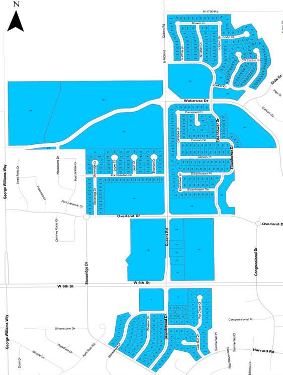
EXHIBIT A
THE STREET IMPROVEMENT DISTRICT
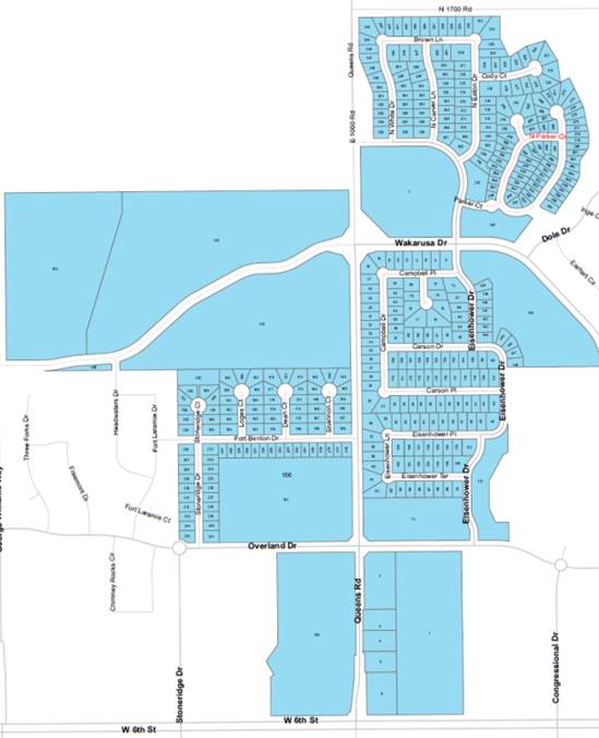
EXHIBIT B
THE SIGNAL IMPROVEMENT DISTRICT