Memorandum
City of Lawrence
Planning & Development Services
|
TO: |
Thomas M. Markus, City Manager |
|
FROM: |
Planning Staff |
|
DATE: |
December 6, 2016 |
|
RE: |
East Lawrence Neighborhood Rezoning Initiation Memo |
SUMMARY
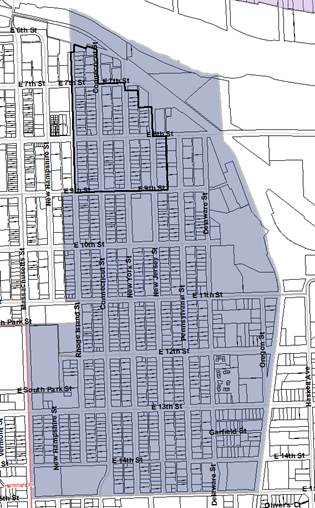
On August 18, 2015, the City Commission directed staff to prepare an initiation memo regarding the potential rezoning of the area north of E 9th Street in the East Lawrence Neighborhood. The subject area is located south of the Kansas River, west of ATSF Railroad tracks, north of E 9th Street, and east of Rhode Island Street (Figure 1).
The rezoning request was made by representatives of the East Lawrence Neighborhood based on a desire to protect the existing residential character of the neighborhood. Many of the residential land uses within the subject area contain Detached Dwellings (single-family homes); however, the zoning associated with the majority of these properties does not accurately align with their existing land use. Many of the residential properties are zoned either RM24 (Multi-Dwelling Residential) or RSO (Single-Dwelling Residential – Office) Districts. The intent of the rezoning request is to rezone these residential properties to a zoning district that better corresponds with the existing use. For example, a property developed with a single family home would be rezoned to the RS5 (Single-Dwelling Residential) District, properties that contain a duplex would be rezoned to the RM12D (Multi-Dwelling Residential - Duplex) District, and the properties with existing multi-family structures would keep the current RM24 zoning.
There are also some residential properties within the subject area with CS (Commercial Strip) zoning. These properties would also be rezoned to a zoning district that aligns with their existing use.
This initiation memo contains four sections which include Background, Policy, Process, and Staff Recommendation. First, the Background section explores the history of the land use planning and zoning in the area, provides data on the existing conditions, and discusses the feedback from members of the neighborhood that was received at a public engagement event. Second, the Policy section addresses the scope of the rezoning and the potential remedies for nonconformities created by the rezoning. Third, the Process section outlines the necessary steps associated with the rezoning. Fourth, a staff recommendation is provided in this final section.
|
|
|
|
Figure 1a. East Lawrence Neighborhood highlighted. Subject area outlined in black. |
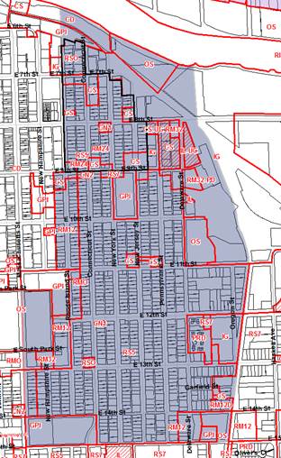
Figure 1b. Zoning in the East Lawrence Neighborhood. Subject area outlined in black. |
1. BACKGROUND
A. History of Land Use Planning and Zoning of the East Lawrence Neighborhood
The section below provides an overview of the planning documents specifically related to the East Lawrence Neighborhood, as well as a timeline of applicable zoning within the neighborhood.
EAST LAWRENCE NEIGHBORHOOD PLAN
The East Lawrence Neighborhood Plan was adopted by the Lawrence-Douglas County Planning Commission on December 19, 1979. The purpose of the document was to provide an official guide to the future development of the neighborhood. The Plan designates most of the East Lawrence Neighborhood as low-density residential (Figure 2). This designation was based on the premise that the existing single-family homes were providing irreplaceable housing for low-income families. Individuals who participated in the development of the Plan expressed concern that a higher density designation would contribute to pressures for redevelopment that could displace the existing residents.
|
|
|
Figure 2. Future Land Use Map from East Lawrence Neighborhood Plan. Subject area is outlined in black. |
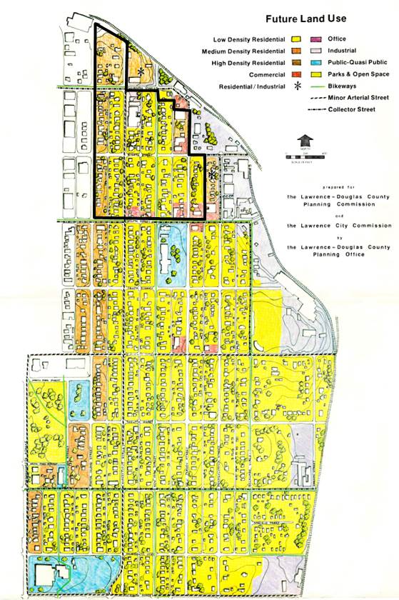
At the time of the Plan’s adoption, the subject area was zoned RM-2 (Multiple-Family Residence) District, which the applicable zoning code defined as “areas which contain single-family and two-family dwellings, are centrally located, and are appropriate to ultimate multi-family development.”
The Plan emphasizes that it is a land use plan, and not a rezoning plan. It states that it does not recommend that all areas designated low-density residential be rezoned to a single-family designation, although it also states that it may be desirable if a large percentage of the property owners are in support of a rezoning.
ORDINANCE 5427
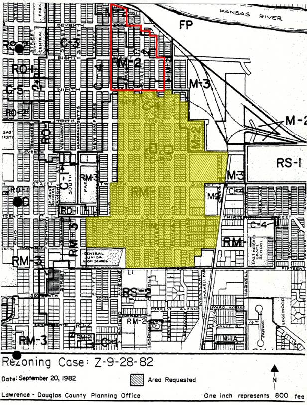
On January 18, 1983 the City Commission approved an ordinance providing for the rezoning of certain lots in the East Lawrence Neighborhood from RM-1, RM-2, M-2 (General Industrial) and C-4 (General Commercial) to RS-2 (Single-Family). The affected area was south of E 9th Street, east of Rhode Island, north of 15th Street, and west of the ATSF Railroad tracks (Figure 3). This Ordinance did not include the subject area north of E 9th Street and as such, the area remained zoned for multi-family uses.
|
|
|
Figure 3. Area rezoned by Ordinance 5427 highlighted yellow. Subject area outlined in red. |
EAST LAWRENCE NEIGHBORHOOD REVITALIZATION PLAN
Created with the purpose of preserving the important features of the neighborhood, the East Lawrence Neighborhood Revitalization Plan was adopted by the City Commission on November 21, 2000. The Plan states that it is “not a land use plan but a preservation and social action strategy to maintain features that are most important to the homeowners, property owners, business owners, and tenants.” The first goal of the six identified in the plan is “Encourage effective code enforcement, maintain appropriate land use and zoning and develop a true sensitivity to housing issues.”
The Plan does not discuss rezoning as a potential implementation option; however, it does recommend the creation of a ‘Single Family Strategies Task Force’. The stated objective of the task force was to work with the City to develop mechanisms to limit the illegal conversion of single-family units into multi-family housing.
The Plan also recommends the creation of a ‘Planning and Design Standards Task Force’ to revise construction and planning standards to reflect the unique character of the neighborhood, and to protect the single-family zoning.
LAND DEVELOPMENT CODE
The City of Lawrence adopted the current Land Development Code on July 1, 2006. With the adoption of the new code, the zoning associated with the subject area was converted to reflect the new zoning designations. The Code included a new single-dwelling district to accommodate many of the smaller Original Townsite properties that were zoned RS-2. Many of these properties were zoned to RS5 (5,000 square feet minimum lot area). The properties within the subject area that had previously been zoned RM-2 were converted to RM24, a multi-dwelling district with similar density to that permitted in the previous RM-2 District .
Conclusion of Land Use Planning and Zoning History
A review of the previous land use plans and zoning pertaining to the East Lawrence Neighborhood shows that the rezoning request would comply with these land use plans.
B. Existing Conditions
The information below is provided to facilitate a better understanding of the existing conditions of the subject area. This section includes information on the existing land uses and zoning districts, the active rental licenses in the area, a residential density comparison, and a summary of the neighborhood public engagement.
EXISTING LAND USES AND ZONING DISTRICTS
RM24 Zoning District
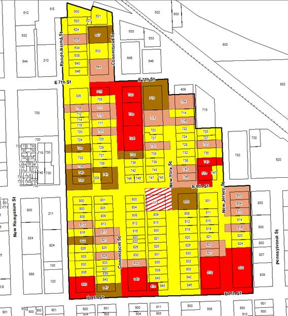
With the current RM24 zoning, a variety of multi-family housing options are permitted by right, while a Detached Dwelling is permitted with approval of a Special Use Permit. Because the area was developed prior to the adoption of the current Land Development Code the subject area contains multiple nonconforming Detached Dwellings. While these Detached Dwellings came into existence legally, they do not meet the standards of the RM24 District zoning. To determine how many nonconforming Detached Dwellings exist in the subject area, data was collected via the County Appraiser and field research. Table 1 shows the number of Detached Dwellings, Duplexes, Multi-Dwelling Structures, and Accessory Dwelling Units located within the RM24 District. According to this data, 69% of the existing properties zoned RM24 District do not comply with the current zoning.
|
Street Name |
Detached Dwelling – No ADU |
Detached Dwelling – With ADU |
Duplex |
Multi-Dwelling Structure |
Vacant |
Total |
|
|
Rhode Island |
12 |
1 |
2 |
3 |
1 |
19 |
|
|
Connecticut |
23 |
1 |
7 |
3 |
0 |
34 |
|
|
New York |
30 |
0 |
6 |
1 |
2 |
39 |
|
|
New Jersey |
9 |
0 |
7 |
0 |
1 |
17 |
|
|
E 7th Street |
0 |
0 |
0 |
1 |
0 |
1 |
|
|
E 8th Street |
1 |
0 |
0 |
0 |
|
1 |
|
|
Total |
75 |
2 |
22 |
8 |
4 |
111 |
|
|
Percentage |
67% |
2% |
20% |
7% |
4% |
100% |
|
|
Table 1. Housing types within the subject area zoned RM24 District. |
|||||||
RSO Zoning District
The RSO zoning district is located north of E 7th Street. This area contains one Duplex and one Multi-Dwelling Structure. The rest of the developed lots contain Detached Dwellings. The Duplex and Detached Dwelling uses are permitted uses within this district. Multi-Dwelling Structures are not a permitted use in this zoning district and they comprise 8% of the this RSO District.
The Land Development Code indicates that the primary purpose of this zoning district is to “accommodate low to medium-intensity administrative and professional offices that are compatible with the character of low and medium-density residential neighborhoods. The district is also intended to be used as a transitional zoning district between higher intensity commercial areas and residential neighborhoods.”
|
Street Name |
Detached Dwelling – No ADU |
Detached Dwelling – With ADU |
Duplex |
Multi-Dwelling Structure |
Vacant |
Total |
|
|
Rhode Island |
6 |
0 |
1 |
0 |
1 |
8 |
|
|
Connecticut |
2 |
0 |
1 |
1 |
0 |
4 |
|
|
Total |
8 |
0 |
2 |
1 |
1 |
12 |
|
|
Percentage |
67% |
0% |
17% |
8% |
8% |
100 |
|
|
Table 2. Housing types within the subject area zoned RSO District. |
|||||||
CS Zoning District
There are some properties with Detached Dwelling, Duplex, and Non-Ground Floor Dwelling uses developed within the CS District. The Non-Ground Floor Dwelling use is permitted within this district, however the Detached Dwelling and Duplex uses are not. As such, 67% of the housing types within the CS District are nonconforming uses.
|
Street Name |
Detached Dwelling– No ADU |
Duplex |
Multi-Dwelling Structure |
Non-Ground Floor Dwelling |
Vacant |
Total |
|
|
Rhode Island |
0 |
1 |
0 |
0 |
0 |
1 |
|
|
Connecticut |
2 |
0 |
0 |
0 |
1 |
3 |
|
|
New York |
1 |
0 |
0 |
0 |
0 |
1 |
|
|
New Jersey |
1 |
0 |
0 |
0 |
0 |
1 |
|
|
E 7th Street |
1 |
0 |
0 |
0 |
0 |
1 |
|
|
E 8th Street |
0 |
0 |
0 |
0 |
0 |
0 |
|
|
E 9th Street |
0 |
0 |
0 |
2 |
0 |
2 |
|
|
Total |
5 |
1 |
0 |
2 |
1 |
9 |
|
|
Percentage |
56% |
11% |
0% |
22% |
11% |
100% |
|
|
Table 3. Housing types within the subject area zoned CS District. |
|||||||
|
|
|||||||
|
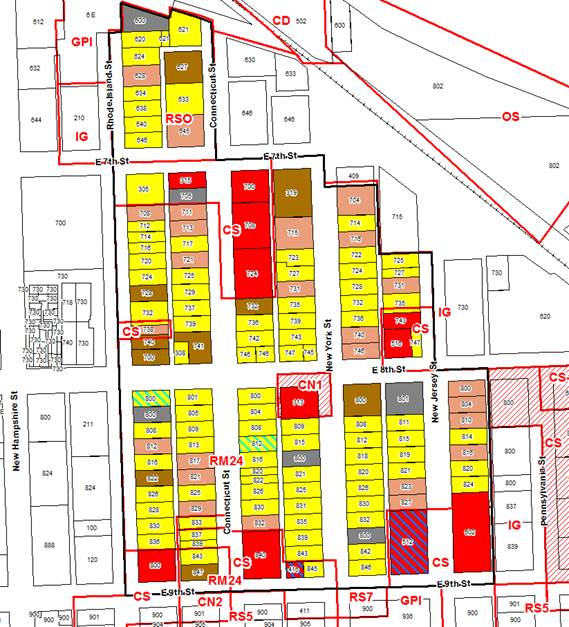
Figure 4. Location of residential uses in the subject area and existing zoning districts. |
|||||||
|
Detached Dwelling |
ADU |
Duplex |
Multi-Dwelling Structure |
Non-Ground Floor Dwelling |
Commercial/Industrial |
Vacant |
Subject Area |
ACTIVE RENTAL LICENSE
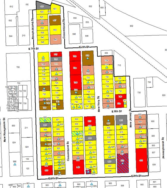
Figure 5 below shows the location of active rental properties within the subject area. Currently, there are 65 active rental licenses and of those, 34 belong to properties with Detached Dwellings. As such, 52% of the active rental licenses within the subject area are associated with a single-family use and would be affected by a reduction in Occupancy Limits permitted per Section 20-601(d) of the Land Development Code.
|
|
|||||||
|
Figure 5. Location of active rental licenses within the subject area. |
|||||||
|
Active Rental Licenses |
|||||||
|
Detached Dwelling |
ADU |
Duplex |
Multi-Dwelling Structure |
Non-Ground Floor Dwelling |
Commercial/Industrial |
Vacant |
Subject Area |
NEIGHBORHOOD DENSITIES
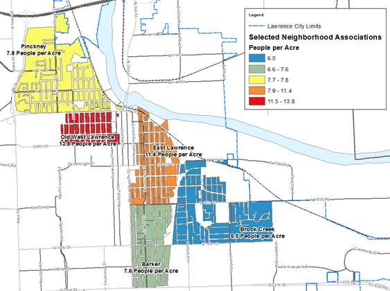
At the public meeting held on March 28, 2016, a question was asked related to the population densities of the East Lawrence neighborhood and adjacent neighborhoods. Figure 6 below provides a comparison of the residential density, based on the U.S. Census, of the East Lawrence neighborhood to the surrounding neighborhoods, which include Barker, Brook Creek, Old West Lawrence, and Pinckney. In this sample, the Brook Creek neighborhood has the lowest population density with 6.5 people per acre, and Old West Lawrence has the highest with 13.8 people per acre. The East Lawrence neighborhood has 11.4 people per acre. This data represents the entire East Lawrence neighborhood and is not specific to the subject area north of E 9th Street.
|
|
|
Figure 6. Based on U.S. Census, the map shows the population densities of the East Lawrence and surrounding neighborhoods. |
HISTORIC ENVIRONS
In the East Lawrence neighborhood, north of E 9th Street, there are six properties listed on the Lawrence Register. Properties within 250’ of these listed properties are considered to be within the historic environs. As shown in Figure 7 below, the majority of the properties are located within historic environs. Also, the properties located on Rhode Island Street are in the North Rhode Island Historic District.
The properties located within the historic environs are subject to review by the Lawrence Historic Resources Commission when exterior construction, alteration or removal requires a city permit; or when demolition is proposed that requires a city demolition permit. No review is required for ordinary maintenance or repair of a structure or building, or for interior maintenance that does not require exterior alterations.
|
|
||
|
Figure 7. Historic Environs located north of E 9th Street in the East Lawrence Neighborhood. |
C. Neighborhood Public Engagement
Staff held a public meeting on March 28, 2016 at the Lawrence Public Library to discuss the potential rezoning with interested members of the public. The purpose of the meeting was for staff to share the data collected and obtain feedback regarding the analysis and the potential rezoning. The meeting was attended by approximately 30 people.
The comments provided during the discussion indicated that there is not a consensus regarding the potential rezoning. Some members of the public expressed the need to prevent further intensification of the neighborhood. They stated that the existing rental properties in the subject area presented no issues, but they worried that the RM24 zoning would allow property owners to consolidate lots and build Multi-Dwelling Structures that would increase the density of the area. Other members of the public stated that given the proximity to downtown, the area was suited for higher density. These individuals stated that gentrification of the area and its effects on property taxes was a concern. A concern for maximizing structure size under the current RS5 standards was also noted as a cause leading to the potential for gentrification.
Other questions that were discussed during the meeting included:
- What will be the scope of the rezoning? Will it only include the RM24 properties? Would the properties zoned RSO (Single-Dwelling Residential – Office) located to north of E 7th Street be included?
- Would the rezoning only include properties that contain Detached Dwellings or would properties with Duplex and Multi-Dwelling Structures be rezoned to an applicable district?
- How will nonconformities created by the rezoning be handled?
- How will the rezoning affect undeveloped lots?
- Can property owners ask to be excluded from the rezoning?
- How will rezoning affect the owner occupancy limits of the existing rental properties?
Many of these questions are discussed further in the Policy section below.
2. POLICY
A. Scope of the Rezoning
As seen above, many of the questions and comments received at the public meeting centered on the scope of the rezoning. When considering a possible rezoning of the area, the scope should be clearly defined. Given this, below are questions that when answered can help provide direction on a rezoning.
i. Should participation in the rezoning be voluntary or mandatory?
ii. Should the rezoning include only the Detached Dwelling properties currently zoned RM24 or should all residential uses within the subject area be included?
iii. Should the rezoning include only the Detached Dwelling uses or should all properties be zoned to a zoning district that better corresponds to their existing use (See ‘Nonconforming Land Uses’ below for further explanation)?
At the May 24, 2016 City Commission meeting, the direction provided to staff answered these questions related to scope. The Commission directed staff to rezone all properties in a mandatory fashion, to expand the subject area to include all residential properties north of E 9th Street, and to zone to the existing use.
B. Nonconforming Remedies
NONCONFORMING LAND USES
If a blanket rezoning were completed within the subject area, the result would be the creation of nonconforming uses on some properties. For example, if the entire RM24 District within the subject area were downzoned to the RS5 district, the properties with Duplex and Multi-Dwelling Structure uses would become nonconforming. Rezoning based on the properties existing use would alleviate this potential issue.
Another land use that would be nonconforming if rezoned to RS5 is the Accessory Dwelling Unit (ADU) component of a single-family district. Based on field research, it is estimated that there are 3 properties within the subject area that contain a Detached Dwelling with an ADU. The single-family zoning districts that permit this land use are RS7, RS10, RS20, and RS40. ADUs are not permitted in the RS5 District. Given the existing lot sizes, it is unlikely that the subject area would be rezoned to any of these zoning districts (see ‘Nonconforming Lots’ below). Therefore, rezoning to the RS5 District that corresponds with the existing lot sizes of the area would create a nonconforming situation for properties that contain a Detached Dwelling with an ADU. Staff attempted twice to amend the code to allow ADUs in the RS5 District but was met with opposition from neighborhood groups. Therefore, staff would not recommend changing the code to accommodate this condition. Instead, staff recommends maintaining those uses as nonconforming in the RS5 District by registering their use. Under the current code, the use would cease if the structures are damaged past 60% of their fair market value.
NONCONFORMING LOTS
Section 20-601(a) of the Land Development Code provides the Density and Dimensional standards of the residential zoning districts. The lot area associated with a large portion of the properties within the subject area would meet the dimensional requirement of RS5 zoning district, which requires a minimum lot width of 5,000 square feet. Of the 91 properties that would be rezoned to the RS5 District, all but 14 would meet the minimum lot area requirement.
The minimum lot width requirement for the RM12D District is 6,000 square feet. Of the 25 properties that would be rezoned to the RM12D District, 21 of the properties would not meet this requirement. The other properties have a minimum lot area of approximately 5,850 square feet and after the rezoning these properties would be nonconforming in meeting the minimum lot area standard.
There are properties currently zoned RM24 District with Multi-Dwelling Structure uses that do not meet the minimum lot area standard for the RM24 District. Those properties were not included in this analysis given that the existing zoning for the Multi-Dwelling Structures within the RM24 District is not proposed to change.
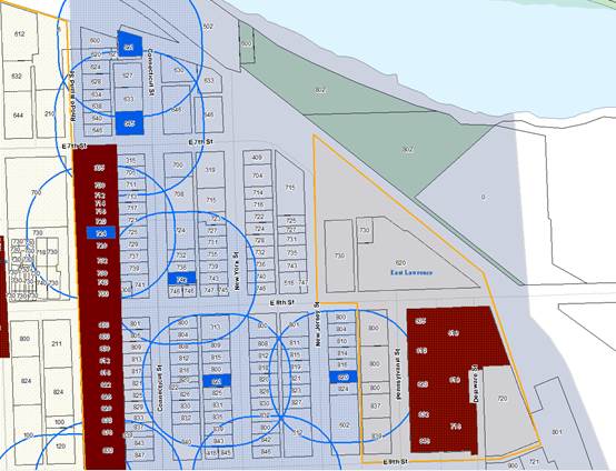
Based on data obtained from the parcel layer maintained by the County and used in the GIS mapping software, Figure 8 below shows the location of the properties that would not comply with the required lot area associated with the new district if rezoned. If rezoned, staff would submit these properties to the Board of Zoning Appeals for lot size and setback variance considerations.
|
|
||||
|
Figure 8. Location of the properties with nonconforming lot sizes, and properties with Accessory Dwelling Units in the subject area. |
||||
|
RS5 Nonconforming Lot Area |
RM12D Nonconforming Lot Area |
ADU |
Subject Area |
|
OCCUPANCY LIMITS
Per Section 20-601(d) of the Development Code, the maximum number of unrelated occupants per dwelling unit permitted in an RM district is 4, while the maximum number permitted in an RS district is 3. As discussed earlier, there are currently 38 active rental licenses in the subject area associated with Detached Dwellings. Rezoning these properties to the RS5 district will lower the occupancy limits from 4 unrelated occupants to 3 and will potentially reduce income for these owners. There is precedent for reducing occupancy. In 2001, the city reduced occupancy limits in the RS districts from 4 unrelated occupants to 3 and provided three years for owners to comply with the new standard. Staff recommends employing a similar program for those properties rezoned to RS5.
3. PROCESS
The process related to rezoning is outlined below.
1. Initiation:
A rezoning can be initiated by the City Commission or the Planning Commission. Staff provides a motion to initiate this effort at the end of this memo.
2. Notification:
The process would include a Planning Commission public hearing, of which the public would be notified via newspaper and sign posting, and property owners located in the rezoning area and within 400 feet of the proposed rezoning boundary would receive mailed notification.
3. Neighborhood Meeting:
Staff would work with the East Lawrence Neighborhood Association (ELNA) to facilitate a neighborhood meeting to discuss the rezoning with property owners and tenants. Input gathered from this meeting would be considered during the staff review and included in the report findings.
4. Staff Review:
Planning staff would review the rezoning request based on the criteria found in the Development Code and provide a report of findings to the Planning Commission and the City Commission.
5. Historic Resources Commission:
The Historic Resources Commission (HRC) would review the rezoning request based on the criteria found in Chapter 22 Conservation of Historic Resources of the City Code and would provide a recommendation to the City Commission.
The HRC would also perform a state law review using the Secretary of the Interior Standards and Guidelines for Rehabilitation to make a determination.
6. Planning Commission:
The Planning Commission will conduct a public hearing, after which the body will make a recommendation to the City Commission to approve, approve with conditions, or deny the rezoning request.
7. Protest Petition:
A protest petition may be submitted within 14 days of the conclusion of the Planning Commission’s public hearing. To be considered valid, a protest petition would need to contain signatures of a minimum of 20% of the property owners within the proposed rezoning boundary, or a minimum of 20% of property owners surrounding the boundary.
8. City Commission:
Following the 14 day waiting period, the City Commission will receive the Planning Commission’s and the Historic Resources Commission’s recommendations and will then consider the request. If approved, the rezoning would become effective upon publication of the adopting ordinance.
4. STAFF RECOMMENDATION
Staff recommends the following scope for this rezoning.
- Rezone the Detached Dwellings in the RM24, RSO, and CS Districts to the RS5 District.
- Rezone the Duplexes in the RM24, RSO, and CS Districts to the RM12D District.
- Include with the rezoning ordinance a provision that properties within the RS5 District have a three year period to comply with the 3 unrelated occupant standard of the RS5 District (reduced from 4 in the RM24 District).
- Direct staff to submit nonconforming lots to the Board of Zoning Appeals for lot size and setback variance considerations.
- Register known Accessory Dwelling Units as legal nonconforming uses.
Action Requested
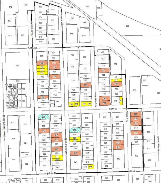
Initiate rezoning multiple properties to align the properties’ current use with the zoning districts, as identified in the Staff memo, that contain the appropriate density and intensity standards to support the uses. The properties to be rezoned are in an area of the East Lawrence neighborhood, as identified on a map in the Staff memo, and generally bound by 9th Street to the south, Rhode Island Street to the west, various streets to the east but no farther than the alley between New Jersey Street and Pennsylvania Street, and the Kansas River to the north. This item will receive a hearing before the Planning Commission with notice to all affected properties and to owners within 400 feet of the affected properties.
|
|
|||||
|
Figure 9. Zoning map that shows the potential zoning districts if the rezoning process were initiated and approved. |
|||||
|
RS5 |
RM12D |
RM24 |
CN1 |
CS |
Subject Area |