Analysis of Environs of 819
Avalon Road, Patrick Mugan Residence
Step
One
Historical
Significance and Context
According to the application for Historic
Landmark Designation, the original portion of the existing structure located at
819 Avalon Road was constructed in 1866. The property is being nominated to the
Lawrence Register of Historic Places under local criteria one and six. Local
criteria one is a property’s character, interest, or value as part of the
development, heritage or cultural characteristics of the community, county,
state, or nation. Local criteria six is embodiment of elements of design,
detailing, materials, or craftsmanship that render it architecturally
significant.
The importance of this structure’s visual
and physical characteristics influences the environs definition process in that
it is good example of a vernacular gable front and wing style of architecture.
The structure maintains integrity in location and design.
The
period of significance for the related nomination categories is as follows:
Local Register Criteria One
Value as an example of the development
patterns associated with the growth of Lawrence 1884 to 1956.
Local
Register Criteria Six
Because this criterion is based on
architectural elements there is no specific period of significance.
Step
Two
Historical
Character of the Area Surrounding the Property
Historical character is the primary issue
considered in this section. Historic photographs, Sanborn Fire Insurance Maps,
the nomination information, 1873 Douglas County Atlas, Living with History: A
Historic Preservation Plan for Lawrence, Kansas, by Dale Nimz, and Historic
Resources of Lawrence, Douglas County, Kansas Multiple Property Documentation
Form (MPDF) are the primary sources used to identify the historic character of
the area.
Natural Features The environs
consisted of hilly ground associated with the proximity to Mount Oread.
Property Boundaries
and Ownership Patterns Property boundaries in this area of
Lawrence were large tracts of land varying in size. Typically each tract was
owned individually. Tracts were subdivided and subsequently platted into
residential lot sizes. In 1956 the property was platted as Broadview Terrace
Addition. As the area developed during the period of significance, ownership
patterns primarily changed to individual owners for individual lots.
Land Use Patterns and Zoning Land use in the
area was mainly agricultural with some undeveloped land. Some of the tracts
developed with farm houses for single family use. There was no zoning in the
area at the time of construction. The property was not located in the City of
Lawrence on the 1929 or 1935 zoning maps. On the 1966 zoning map the property
was zoned RS-2.
Circulation Patterns The final street
development was established in 1956 with the subdivision plat. Avalon Road was
platted at an angle and connected to West 9th Street at an angle.
The street had a 60’ right-of-way and a right-angle turn at the north end of
the street that was a dead end.
Planned Vegetation
Patterns
Historically there was vegetation on property consistent with the settlement
patterns of the tract and the construction of the house. In some areas, trees
and shrubs were planted and a kitchen garden may have existed.
Signs and Pedestrian amenities At the time of
construction, there were no signs or pedestrian amenities.
Primary Structures There were few
primary structures in the area when the structure was built. 837 Avalon Road
was constructed c. 1860, but almost all of the development along Avalon Road
occurred during 1958 and 1962. While the primary structure for 819 Avalon Road
is a vernacular form of architecture from the 1860s, the remainder of the
primary structures in the area, with the exception of 837 Avalon Road, are a
mix of various sub-types of the ranch style and split level structures.
Building materials also vary but include brick veneer and wood siding.
Fenestration patterns vary but most of the structures have a primary entrance
that faces the street.
Secondary Structures.
There
were few secondary structures in historic area. The secondary structures for
the Mugan residence were likely simple structures associated with the rural
location. As development of the residential structures in the area occurred,
there were very few accessory structures.
Outdoor Activity Spaces Outdoor spaces were
originally defined by the large tracts of undeveloped land. As the area
developed, open space was primarily limited to the portions of the individual
lots that were not encompassed with structure. There were no city parks in the
area.
Utilities and
Mechanical Equipment City utilities and mechanical equipment
were primarily introduced when the area was incorporated into the city and when
the subdivision was developed. The plat for the subdivision indicates the right
to construct and maintain pipes for water, gas, and sewers and poles for
electricity and telephones.
Views The views to the listed property were
expansive when the Fuller House was constructed. As the tract was subdivided,
views were reduced to the typical views of lots in a developed subdivision.
Step Three
Present
Character of the Area Surrounding the Property
The primary source of information on this
section is personal observation, city zoning maps, and recent aerial
photographs.
Natural Features The environs
consist of hilly ground associated with the proximity to Mount Oread.
Property Boundaries
and Ownership Patterns Property boundaries in this area are
primarily consistent with the platted residential lots. Ownership patterns of
the individual lots are typically individual owners for each lot. Some lots
have been combined to provide individual owners with larger parcels. The
property to the southeast was developed as an apartment complex.
Land Use Patterns and Zoning The land use
patterns for the area are consistent with the ownership patterns. The zoning
supports the residential detached dwelling (single dwelling) use and the
multifamily zoning use for the area to the southeast.
Circulation Patterns Vehicular
traffic in the area is primarily local traffic on the improved streets;
however, the access to the apartment complex to the southeast is off of Avalon
Road and creates more traffic than a typical street of this size. The northeast
portion of the street is a dead end as is W 8th Terrace to the east
approximately mid-block. The main street to the south, 9th Street,
is a minor arterial and has significant vehicular traffic.
Planned Vegetation Patterns The landscape in
the area is mature and typical for a subdivision of this age. The planned
vegetation in the front yards consists of mature trees and plant beds with both
annual and perennial plantings. Due to the change in elevation from the street
to the houses on the west side of Avalon Road, much of the street level yards
have a considerable amount of vegetation that obscures the views to the primary
structures.
Signs and Pedestrian amenities Signs in the area
vary, but typically they are road signs with street names and traffic signs.
There are no pedestrian amenities including sidewalks.
Primary Structures 819 and 837 Avalon
Road are the only primary structures of a historic vernacular form in the area.
Development of the remaining primary structures is from the late 1950s and
1960s, and consists of various sub-types of the ranch style and split level
structures. Building materials include brick veneer and wood siding.
Fenestration patterns vary but most of the structures have a primary entrance
that faces the street.
Secondary Structures There are very few
secondary structures in the area. While 819 Avalon Road has a detached garage,
most garages in the area are attached.
Outdoor Activity Spaces Open space is
primarily limited to the portions of the individual lots that are not
encompassed with structure. There are no city parks in the area.
Utilities and Mechanical Equipment There are storm
sewer inlets, traffic signs and some street lighting along streets in the
area. Water meter and manhole covers are typical through the area. Fire
hydrants are located along the streets. City water and sewer lines are
primarily in the streets Mechanical equipment consists primarily of HVAC units
that are located on the ground adjacent to the primary structures and behind
the front building plane. Electrical and telephone lines exist in the area.
Views Views to and from the nominated property
are limited due to the topography and residential development of the area. In
addition, views are often obscured by the mature vegetation in the area.
Step Four
Comparison of the Historic and
Present Character of the Area Surrounding the Property.
Natural Features The natural features
remain the same. Some of the original grade of the area has been altered to
accommodate new construction.
Property Boundaries and Ownership Patterns The large tracts
of land have been subdivided, but this occurred prior to the present day
character of the area. The typical property boundaries and ownership patterns
of the area are similar today to what they were when the area was developed.
Land Use Patterns and Zoning The land use
patterns and zoning for the area is consistent with the historic patterns and
zoning of the area.
Circulation Patterns The circulation
pattern has changed since the period of construction for the property but is
consistent with the 1956 design shown on the plat.
Primary Structures The majority of
primary structures in the area continue to be residential structures with the
exception of the apartment complex to the southeast.
Secondary
Structures Almost no secondary structures exist.
Outdoor Activity Spaces Open space continues
to be limited to the portions of the individual lots that are not encompassed
with structure. There are no city parks in the area.
Utilities
and Mechanical Equipment While utilities and mechanical equipment
have significantly changed since the construction of the property, the
utilities and mechanical equipment are primarily the same as they were in the
later development pattern.
Views The views in the area have changed
since the periods of significance due the growth of the landscape features
including trees and large shrubs.
Conclusion
While the Environs for 819 Avalon Road, the
Mugan Residence, have changed since the c 1866 date of construction, the
environs have not significantly changed since the 1956 plat and subsequent
development. Because there is a significant difference between dates of the
construction period of the property and the development of the area after the
development of the area post the 1956 plat, staff recommends the commission use
the development pattern created by the final establishment of the area before
1966 which is the date (50 years or older) established by the National Park
Service for the eligibility of properties to be identified as historic.
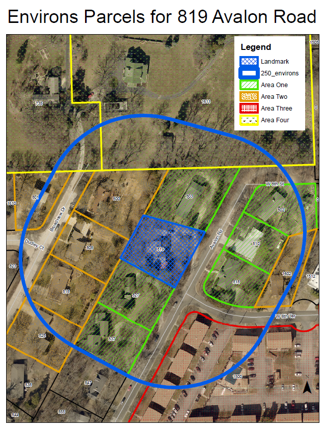
The
environs should be divided into four areas and reviewed in the following
manner.
Area One
The area primarily
consists of residential structures with some line of site sight to the
landmark. The residential character of the environs in this area is important.
The area should maintain the overall residential character of the historic
environs and the following should apply:
The proposed
alteration or construction should meet the intent of the Criteria set forth in
22-505. Important design elements include scale, massing, site placement,
height, directional expression, percentage of building coverage to site,
setback, roof shapes, rhythm of openings, and sense of entry. Demolition of properties
shall be approved if a compatible structure is proposed on the site.
Maintaining views to the listed property and maintaining the rhythm and pattern
within the environs are the primary focus of review.
All projects except
for demolition of main structures and new infill construction will be reviewed
administratively by the Historic Resources Administrator. The proposed
alteration or construction should meet the intent of the Criteria set forth in
22-505. The main issues in the review are the continuation of the residential
character of the area and whether the project will encroach upon, damage or
destroy the environs of the listed property. If the project does not meet the
Criteria set forth in 22-505, the project will be forwarded to the Historic
Resources Commission for review.
Demolition of main
structures and new infill construction will be reviewed by the Historic
Resources Commission. The proposed alteration or construction should meet the
intent of the Criteria set forth in 22-505. The main issues in the review are
the continuation of the residential character of the area including setbacks,
size, scale, and massing.
Area Two
The area located to
the west of the landmark and the property located at 1602 W 8th
Terrace are residential and consist of structures constructed after 1958. The
residential character of the environs in this area is important. The area
should maintain the overall residential character of the historic environs and
the following should apply:
All projects will be
reviewed administratively by the Historic Resources Administrator. The proposed
construction should meet the intent of the Criteria set forth in 22-505. The
main issues in the review are the continuation of the residential character of
the area and whether the project will encroach upon, damage or destroy the
environs of the listed property. If the project does not meet the Criteria set
forth in 22-505, the project will be forwarded to the Historic Resources
Commission for review. The main issues in the review are the continuation of
the residential character of the area including setbacks, size, scale, and
massing.
Area Three
The area to the
southeast of the landmark has developed as an apartment complex. The design in
this area is not currently compatible with the residential patterns, including
residential primary structure forms. If at some point in the future the
property redevelops, the residential character of the environs should be
respected. New construction as a result of the redevelopment of the property
should maintain the overall residential character of the historic environs.
All projects except
for new infill construction or new redevelopment construction will be reviewed
administratively by the Historic Resources Administrator. The proposed
alteration or construction should not increase the disruption of the
residential character of the landmark. The main issues for the review are the
continuation of the residential character of the area and whether the project
will encroach upon, damage or destroy the environs of the listed property.
New infill
construction or new redevelopment construction will be reviewed by the Historic
Resources Commission. The proposed construction should meet the intent of the
Criteria set forth in 22-505. The main issues in the review are the
continuation of the residential character of the area including setbacks, size,
scale, and massing.
Area Four
The property to the
north of the dead-end streets of Avalon Road and Broadview Drive that is
included within the 250’ environs boundary is predominantly undeveloped land
that is associated with residential structures to the north on large lots. This
area has no line of sight to the listed property. The only possible impact this
area could have on the landmark is out of scale development that is not
compatible with the residential character and patterns of the environs of the
landmark. The area should maintain the overall residential character of the
historic environs and the following should apply:
All projects will be
reviewed administratively by the Historic Resources Administrator. The proposed
construction should meet the intent of the Criteria set forth in 22-505. The
main issues in the review are the continuation of the residential character of
the area and whether the project will encroach upon, damage or destroy the
environs of the listed property. If the project does not meet the Criteria set
forth in 22-505, the project will be forwarded to the Historic Resources
Commission for review.