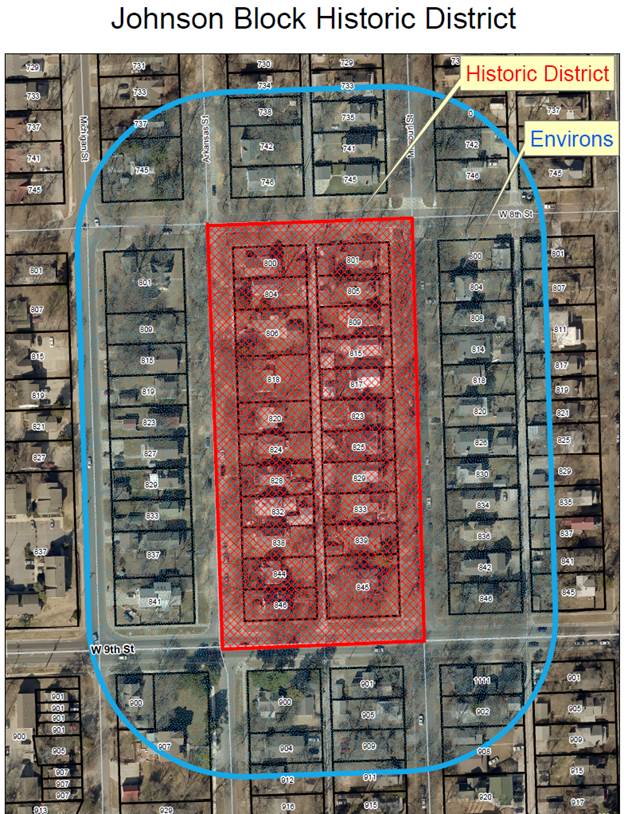
Analysis of Environs of the
Johnson Block Historic District
Step
One
Historical
Significance and Context
The Johnson Block was initially platted as
the Lane Place Addition on March 14, 1871. The block was developed by prominent
local businessman Victor Johnson beginning in 1909 and was almost completely
developed by August, 1949. The original plat and the development starting in
1909 continued the street
grid and lot patterns already established the city. The platted lots and
development pattern also continued the typical size of 50’ X 117’ lots in the
city. The right-of-way established for both Missouri and Arkansas streets was
80’. All of these patterns exist today.
The district is being nominated under local criterion one
and six. Local criterion one is for character,
interest, or value as part of the development, heritage or cultural
characteristics of the community, county, state, or nation. Local criterion six
is embodiment
of elements of design, detailing, materials, or craftsmanship that render it
architecturally significant.
The
period of significance for the related nomination categories is as follows:
Period of Significance for value as part of
the development of Lawrence: 1871 to 1954, the date of the original plat to the
construction of the last primary structure in the district.
Period of Significance for Architecture:
Architectural Significance is based on a structure’s design and is not limited
to a specific period of significance.
The property also maintains sufficient integrity
worthy of preservation.
Step
Two
Historical
Character of the Area Surrounding the Property
Historical character is the primary issued
considered in this section. Historic photographs, Sanborn Fire Insurance Maps,
the nomination information, 1873 Douglas County Atlas, Living with
History: A Historic Preservation Plan for Lawrence, Kansas, by Dale Nimz, and
Historic
Resources of Lawrence, Douglas County, Kansas Multiple Property Documentation
Form (MPDF)
were the primary sources used to identify the historic character of the area.
Natural Features There are
elevation changes in the area to the west, but the block is fairly flat.
Property Boundaries and Ownership Patterns Property
boundaries and ownership patterns reflected the proposed development pattern of
the plats for the area. Typically, the platted areas consisted of individual
structures on individual lots.
Land Use Patterns and Zoning There was no
zoning in 1909. By 1966 the property was zoned for multi-family residential
use.
Circulation Patterns The circulation
patterns were a continuation of the established city street grid pattern. The
development standards for the block included a requirement for concrete
sidewalks.
Planned Vegetation Patterns Planned vegetation
patterns were typical for residential area of the historic period. Because the
development standards required a front yard of 30’, the front yards presented a
cohesive landscape lawn with designed plantings.
Signs and Pedestrian Amenities There were no
documented signs in the area. Concrete sidewalks were mandatory with the
development of a property.
Primary Structures The structures in
the area were one, two, with some two and one-half story structures. The
Johnson residence at 845 Missouri Street had a porte-cochere.
Secondary Structures Secondary structures
were typically garages, barns, and sheds. The majority would have been
constructed of wood. They typically would have been 1 to 2 ½ stories in
height.
Outdoor Activity Spaces There were no public
parks in the immediate area.
Utilities and Mechanical Equipment The information on
the Johnson Block indicates that sewer and water pipes were located in the
alley and gas mains were in the front.
Views The views to the listed property were typical
for new subdivisions in the city.
Step
Three
Present Character of the Area
Surrounding the Property
The primary source of information on this
section is personal observation, city zoning maps, and recent aerial
photographs.
Natural Features There are elevation
changes in the area to the west, but the block is fairly flat.
Property Boundaries and Ownership Patterns Property
boundaries and ownership patterns mainly reflect the proposed development
pattern of the plats for the area. Typically, the platted areas consist of individual
structures on individual lots.
Land Use Patterns and Zoning Land use and
zoning in the surrounding area is residential.
Circulation Patterns The circulation
patterns are historic street grid patterns. Recently a bike lane has been added
to 9th Street.
Planned Vegetation Patterns The planned
vegetation patterns consist of residential lots with yards that include trees
and landscaping beds and features.
Signs and Pedestrian Amenities There are signs in
the area including traffic signs, road name signs, and identification signs. Pedestrian
amenities include sidewalks in most of the surrounding area. Both the Missouri
Street and Arkansas Street right-of-way included in the district have sidewalks.
Primary Structures The structures in
the area are one, two, with some two and one-half story structures.
Secondary Structures Secondary
structures are typically garages and storage buildings. Most are wood frame
with wood sheathing.
Outdoor
Activity Spaces There
are no city parks in the immediate area. The closest outdoor activity space,
other than the property owned by the University of Kansas, is Clinton Park approximately
4/10 of a mile from the district.
Utilities and Mechanical Equipment There are storm
sewer inlets, traffic signs and street lighting along all of the streets in the
area. Water meter and manhole covers are typical through the area. Fire
hydrants are located along the streets. Electrical, cable, and telephone lines
are both above ground and below ground in the area.
Views Views to and from the property are typical
for residential areas in the city. The south end of the block is particularly
visible because 9th Street is a minor arterial for vehicular
traffic.
Step Four
Comparison of the Historic and
Present Character of the Area Surrounding the Property
Natural Features The natural features
are similar to the historic features.
Property Boundaries and Ownership Patterns For the most part, the
property boundaries and ownership patterns continue to be individual dwellings
on individual lots. Some individual structures are located on a combination of
lots or partial lots.
Land Use Patterns and Zoning The land use has not
changed since the development of the area. The city had no zoning when the area
was first developed. Current zoning is consistent with the current use.
Circulation Patterns Street patterns
have not changed. A new bicycle lane has been introduced and the traffic on 9th
Street has significantly increased as development continued to the west.
Primary Structures Primary structures
continue to range in size and style but have not significantly changed since
the historic period.
Secondary Structures The number,
placement, and type of secondary structures are similar to the historic period
and have not changed significantly.
Outdoor Activity Spaces There has been no
change in the available activity space.
Utilities and Mechanical Equipment The character of the
utilities and mechanical equipment in the area are different than in the historic
period. Public and private lighting systems, additional utility lines
including phone, electric, and cable lines have a significant impact on the
visual quality of the area.
Views Overall, the views remain the same.
Conclusion
The Environs of the Johnson Block Historic
District have had minimal change from the historic period. The characteristic residential
patterns of size, scale, massing, materials, setbacks, building orientation, and
height have not been altered. The grid street pattern also continues to exist. The
primary focus of review is to maintain the residential character and forms of
the environs. The environs will be one area and the following standards should
be applied:
Minor
projects (minor additions, porch remodeling, window and door changes,
demolition of outbuildings, etc.) will be approved administratively by the
Historic Resources Administrator if the project meets the intent of the
Secretary of the Interior’s Standards for Rehabilitation and the Criteria set
forth in 22-505, 22-506, and 22-506.1. All design elements are important.
Major
projects (major additions, new infill construction, major alterations, roof
changes, demolition, etc.,) will be reviewed by the Historic Resources Commission.
All design elements are important. The proposed alteration or construction
should meet the intent of the Secretary of the Interior’s Standards for Rehabilitation
and the Criteria set forth in 22-505, 22-506, and 22-506.1. Main structure
demolitions should only be approved only if documentation was provided that
indicated that the structure was unsound and/or a certificate of economic
hardship was approved.