|
PLANNING COMMISSION REPORT Regular Agenda -Public Hearing Item
|
|
PRELIMINARY DEVELOPMENT PLAN FOR 6th & MONTEREY WAY PCD MORGAN ADDITION; 800 MONTEREY WAY (MKM) |
PDP-15-00378: Consider a revised Preliminary Development Plan for a multi-use development consisting of Multi-Dwelling Structures, a Detached Dwelling, and Construction Sales and Services and associated variance from building setback requirement. 6th & Monterey Way PCD Morgan Addition, located on approximately 2.5 acres at 800 Monterey Way. Submitted by Allen Belot Architect, for Robert J. and Beverly G. Morgan, property owners of record.
|
STAFF RECOMMENDATION ON VARIANCE: Planning Staff recommends approval of the variance from the side setback and the rear and peripheral setback to allow the following to be located within the required setbacks:
a. Installation of a 6 ft privacy fence to the south of the shop and associated access drive to provide screening from the residential property to the south.
STAFF RECOMMENDATION ON PRELIINARY DEVELOPMENT PLAN: Planning Staff recommends approval of the Preliminary Development Plan based upon the findings of fact presented in the body of the staff report and subject to the following conditions: 1. If the City Commission approves the connection of the shared access drive to Comet Lane, the sidewalk along the shared access drive will be extended to Comet Lane, the shared access drive shall be named, and the shared drive will be constructed to connect with Comet Lane. 2. Provision of a revised Preliminary Development Plan with the following changes: a. Include a listing of the uses which are permitted in the PDP with the revised uses in the A-2 Phase: Detached Dwelling and Construction Sales and Services. b. Show the complete PCD in the Preliminary Development Plan or provide a copy of the most recently approved PDP along with the revised PDP for this property. c. If the City Commission approves the connection to Comet Lane, list the name of the shared access (private street) and show the shared access/private street and sidewalk being extended to connect to Comet Lane. d. Revise the Interior Parking Lot Landscaping requirement. e. Make revisions to the sanitary sewer and water lines/easements per the City Utilities Department’s approval. f. Note the amount of Common Open Space that is being provided and the percentage of the total site area that it includes and revise the pervious surface figure in the site summary. g. If the variance from the southern setback is approved, show and label a fence to the south of the shop and associated access drive. |
Applicant’s Reason for Request: “This is the last undeveloped parcel remaining in the Sixth & Monterey PCD which was originally approved two decades ago. The property owners under this application were the same owners under the original approval and all subsequent revisions now desire to develop their property.”
KEY POINTS
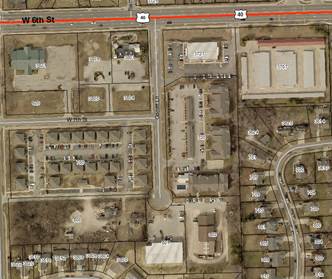
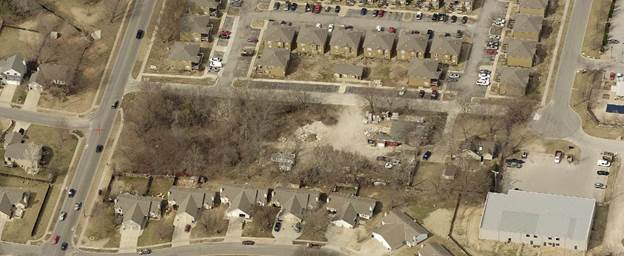
· The property is one of a few remaining undeveloped parcels in the 6th & Monterey Way PCD. (Figure 1)
· The property was included in the previous Preliminary Development Plans for the 6th & Monterey Way PCD, with the first PDP being approved by the City Commission in 1988 and the most recently revised PDP being approved on October 12, 2004. As the development began prior to the adoption of the 2006 Development Code it is being processed under the requirements of the pre-2006 Code.
· The Sixth & Monterey Development was divided into phases, and the Preliminary Development Plans list permitted uses per each phase. Prior to the adoption of the 2006 Development Code, it was necessary to rezone to change the permitted uses. The 2006 Development Code allows changes to be made with a revised Preliminary Development Plan unless the uses were restricted by Zoning Ordinance. As the use restrictions were listed only on the Development Plans, this revised Preliminary Development Plan will revise the permitted uses as well as provide the site layout.
|
|
|
Figure 1. Area within the 6th and Monterey Way PCD is outlined. The subject property is highlighted. Area between access drive and end of Comet Lane is circled. |
· The property owners in the overall Planned Commercial Development did not waive their right to approve or disapprove of changes to the development; therefore their written approval of the revised PDP is required. This has been provided.
· The City Commission denied the subject property access to Comet Lane with the approval of the benefit district for the improvement of 7th Street from Comet Lane to Monterey Way and Comet Lane south of W 6th Street on February 8, 2000. Staff is requesting the City Commission to reverse this decision and allow the proposed development to have access to Comet Lane to improve traffic circulation through the area and provide 2 access points for emergency vehicles.
FACTORS TO CONSIDER
· Compliance with the City of Lawrence Land Development Code, including the purpose of Planned Developments (Section 20-701).
· Conformance with Horizon 2020.
ASSOCIATED CASE
· PF-15-00380: Final Plat for Morgan Addition. The Preliminary Development Plan serves as the Preliminary Plat. A Final Plat has been submitted concurrently with the Preliminary Development Plan and is being considered by the Planning Commission at the September meeting.
OTHER ACTION REQUIRED
· City Commission approval of the Preliminary Development Plan.
· Planning Commission approval of the Final Plat.
· City Commission acceptance of dedications shown on the Final Plat.
· Submittal of a Final Development Plan for Planning Commission approval.
· Recording of Final Development Plan with the Douglas County Register of Deeds.
· Building permits must be obtained prior to construction.
PUBLIC COMMENT
Several public comments were received regarding this development prior to the printing of this staff report. Concerns raised included: green space buffer and trees along Monterey Way and the South side of the property for the existing residences on Elizabeth Ct; impact of lighting on nearby properties; possibly switching the development so the parking is on the south side of the property; height of buildings, preference stated for two-story rather than three-story buildings; increased traffic; drainage.
The applicant discussed these concerns with the property owners and made several changes to the plan. The apartments were revised from three-story to two-story buildings. The buildings are pulled back from Monterey Way approximately 46 ft, but a stormwater detention pond is required in this location so it isn’t possible to protect many of the trees in this area. The applicant provided a tree protection and replacement plan on the Development Plan to insure mature trees on the south side of the property are protected as much as possible. Lighting issues will be addressed with the submittal and review of the Photometric Plan with the Final Development Plan.
|
GENERAL INFORMATION |
|
|
Current Zoning and Land Use:
|
PCD-[6th & Monterey Way] (Planned Commercial Development) District; Construction Sales and Services, Detached Dwelling. Property has development approval for Multi-Dwelling Structure.
|
|
Surrounding Zoning and Land Use:
|
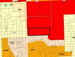
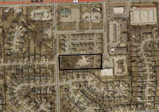
To the north: PCD-[6th & Monterey Way] (Planned Commercial Development) District; Multi-Dwelling Structures. To the west: RS7 (Single-Dwelling Residential) District; Detached Dwellings. To the east: PCD-[6th & Monterey Way] (Planned Commercial Development) District; Construction Sales and Services. To the south: RM24 (Multi-Dwelling Residential) District; Duplex residences.(Figure 2) |
|
|
|
|
Figure 2a. Zoning in the area. Subject property is outlined. |
Figure 2b. Land use in the area. Subject property is outlined. |
|
Area |
|
|
Gross Area |
2.29 acres (99,980 sq ft) |
|
Right-of-Way |
No additional right-of-way being dedicated with this project or the associated Morgan Addition Final Plat |
|
Net Area |
2.29 acres (99,980 sq ft) |
|
Legal Description |
Lot 1 Block 1, Morgan Addition; pending approval of Morgan Addition Final Plat. Section 34 Township 12S Range 19E Beginning at point 881 ft south of NW Corner of NE 1/4 Ten east 580 ft, north 185 ft, west 580 ft, then south S to point of beginning. |
|
SITE SUMMARY |
Existing |
Proposed |
Change |
||
|
Land Use: |
Detached Dwelling, Construction Sales and Service |
Multi-Dwelling Structure; Detached Dwelling; Construction Sales and Service |
Change in use |
||
|
Land Area: |
99,980 sq ft |
99,980 sq ft |
--- |
||
|
Building Area: |
4,630 sq ft |
16,640 sq ft |
+12,010 sq ft |
||
|
Pavement Area: |
5,350 sq ft |
30,815 sq ft |
+25,465 sq ft |
||
|
Impervious Area: |
9,980 sq ft |
47,455 sq ft (47.5%) |
+37,475 sq ft |
||
|
Pervious Area: |
90,000 sq ft |
52,525 sq ft |
- ..37,475 sq ft |
||
|
Parking Summary |
|||
|
Use |
Req. per Article 9 |
Parking Required |
Parking Provided |
|
Detached Dwelling
|
2 spaces per dwelling unit |
2 spaces |
2 spaces |
|
Multi-Dwelling Structure |
1 space per bedroom PLUS 1 space per 10 units for guest parking
|
· 21 one-bedroom apts · 12 two-bedroom apts (45 bedrooms / 33 units) 49 spaces |
49 spaces |
|
Construction Sales & Services |
1 space per each 500 sq ft of floor area PLUS 1 space per acre of outdoor storage or4 assembly |
· 1200 sq ft building/3 spaces · No outdoor storage or assembly area 3 spaces |
3 spaces |
|
TOTAL |
|
54 spaces |
54 spaces |
|
ADA Accessible Spaces |
Detached Dwelling: not required Multi-Dwelling: parking lot with 51-75 spaces requires 3 ADA spaces with 1 being van accessible Construction Sales & Services: none required as business does not include customer activity on site |
3 ADA spaces with 1 being van accessible |
3 ADA spaces all van accessible |
|
Bicycle Parking |
Detached Dwelling: no requirement Construction Sales & Services: 1 per 10 auto spaces Multi-Dwelling Structure: 1 per 4 auto spaces |
Construction Sales & Services: 1 Multi-Dwelling Structure: 13 spaces |
Construction Sales & Services: 1 Multi-Dwelling Structure: 12 spaces |
STAFF ANALYSIS
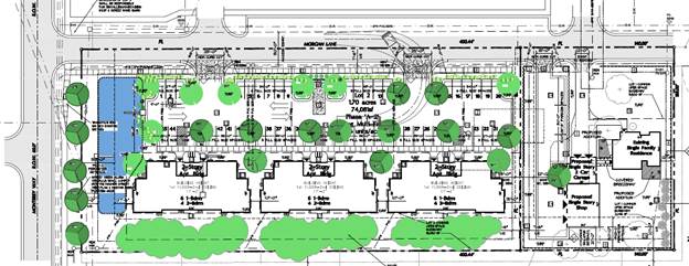
The subject property, addressed as 800 Monterey Way, contains approximately 2.5 acres and is located south of W 6th Street and east of Monterey Way. This property has been part of the Sixth & Monterey Way PCD since its inception. The original plan intended for this area to be developed with apartments; however, the plans now include retaining the existing residence located at the eastern edge of the property. The existing contractor shop will be demolished and a combination automobile garage for the residence and contractors shop will be constructed to the west of the existing house. The remainder of the property will be developed with the previously approved multi-family dwellings.
The previously approved Preliminary Development Plans divided the development by Phases and listed the permitted uses per Phase. The subject property was listed as Phase A-2 in the Preliminary Development Plans. The Development Plan provided this list of permitted uses for this Phase:
Use Group 4. Residential – Multi-Family: Medium and high density multi-family residences.
1. Residential Uses Multi-family dwelling, including duplex
Rooming and/or boarding house
Single-family attached dwelling (row house or townhouse)
Bed & Breakfast Establishment
3. Accessory Uses
Use Group 9. Professional Offices
Offices for medical, professional and governmental purposes and accessory use, not including retail sales to the public, that are of a nature that may be located adjacent to combined with residential uses without harmful effects to said residential uses.
1. Medical and Related Offices
2. Professional and Governmental Offices
3. Veterinarian
4. Financial Institutions
5. Other Offices
6. Accessory Uses
This revised Preliminary Development Plan proposes a revision to this list of permitted uses to include Detached Dwelling and Construction Sales and Services. These uses are both permitted in the PCD-2 District and were not restricted through the zoning ordinance; therefore, the permitted uses can be revised with a revised Preliminary Development Plan. The plan should include a revised sheet showing the uses which are permitted/proposed in the A-2 Phase.
The most recently approved PDP shows 4 two-story multi-dwelling buildings on the south side of the property with parking to the north. This plan keeps the general building layout but reduces the number of structures to 3 with a total of 33 dwelling units. Per Section 20-701(f)(3)(ii) of the Development Code, residential density for Planned Developments is calculated based on the number of bedrooms in each apartment. With this calculation, the density of a 12 unit apartment building would be greater for a building with 12 four-bedroom apartments, than 12 one-bedroom apartments. The residential density of this development would be calculated as: 21 one-bedroom units x .4 dwelling unit = 8.4 dwelling units; 12 two-bedroom units x .6 dwelling unit=7.2 dwelling units for a total of 15.6 or 16 dwelling units.
As noted earlier, the plan modifies the lot layout to add the Detached Dwelling and Construction Sales and Services uses.
The proposed Preliminary Development Plan has been evaluated based upon findings of fact and conclusions per Section 20-1304(d)(9) of the Development Code for the City of Lawrence, requiring consideration of the following nine items:
1) The Preliminary Development Plan’s consistency with the Comprehensive Plan of the City.
This planned development was zoned and received preliminary approval prior to the adoption of the Comprehensive Plan for Lawrence, Horizon 2020. The Future Land Use Map, (page 3-4) shows this area as Medium Density/High Density Residential and Commercial. The proposed development will consist of a mix of uses: medium density residential (apartments); commercial (construction shop); and low density residential (detached dwelling). The area is adjacent to multi-dwelling or commercial uses within the PCD to the north and east and to medium density residential to the south. Low density residential uses are located west of the property across Monterey Way.
Recommendations from Horizon 2020 related to this development are listed below with staff discussion following in red.
Residential Land Use Goals and Policies; Medium and Higher Density Residential Land Use
Goal 2: Create a Functional and Aesthetic Living Environment.
Policy 2.1: Preserve natural features such as natural drainageways, ridgelines and stands of mature trees through sensitive site layout and design.
Policy 2.3 Higher-density residential areas shall be screened from lower-density areas. Where possible, natural barriers and dense vegetation and/or berms shall be used.
Multi-Dwelling development was previously approved on this site. The development is being located in the same area and general configuration as shown on the previously approved plans with the exception of approximately .6 acres on the eastern portion of the property. The existing house will remain on this .6 acres and a combination contractor shop/garage will be constructed. The current plan utilizes two story buildings which will be set back approximately 47 ft from Monterey Way. The buildings will be oriented so the side of one building faces Monterey Way. The parking lot will be screened with a continuous hedge of evergreen shrubs and street trees will be planted along Monterey Way.
The applicant designated an area along the south property line as an area for ‘tree protection’ and noted the steps to be taken during construction to maintain the trees in this area. Some of these trees, however, are located within a 10 ft utility easement. It is the goal of the applicant to maintain all the trees along the south property line, but if utility work is required in this area, trees within or near the utility easement may be damaged or removed. The plan notes that if trees identified for preservation are destroyed or damaged they shall be replaced by similar trees on a 1:1 basis. It will be necessary to locate replacement trees out of any utility easements.
Policy 5.4 Ensure Adequate Ingress and Egress
The site design of a residential development should accommodate multiple points of access (direct and indirect), with attention to directing vehicular traffic to and from a development to collector and/or arterial street/roads.
The original development plan included a shared access easement connecting Monterey Way to Comet Lane. However, the property was not included in the Benefit District for improvements to extend Comet Lane and the City Commission minutes for the Benefit District note that the subject property was not permitted to have access to Comet Lane. (See Attachment) Staff and the applicant are requesting that the City Commission reverse this decision and allow the subject property access to Comet Lane to improve traffic circulation and provide multiple points of access for Fire/Emergency vehicles.
Staff Finding – The proposed development complies with the general residential land use provisions found in Horizon 2020.
2) Preliminary Development Plan’s consistency with the Planned Development Standards of Section 20-701 including the statement of purpose.
The purpose statement includes the following (staff comments follow in italics):
a) Ensure development that is consistent with the comprehensive plan.
As discussed previously, the development is consistent with the comprehensive plan.
b) Ensure that development can be conveniently, efficiently and economically served by existing and planned utilities and services.
City utilities and services currently serve the area and can be conveniently and economically extended to serve the proposed development.
c) Allow design flexibility which results in greater public benefits than could be achieved using conventional zoning district regulations.
This area was zoned and partially developed as a Planned Commercial District prior to the adoption of the 2006 Development Code. The property is being developed per the standards of the Development Code and the standards for Planned Developments in the pre-2006 Code. The development consists of a mix of uses which would not be possible under conventional zoning district regulations but is in keeping with the remainder of the planned development.
d) Preserve environmental and historic resources.
There are mature trees on the property. The plan proposes to protect trees along the south side of the property as much as possible, given that the southern 10 ft lies within a Utility Easement.
e) Promote attractive and functional residential, nonresidential, and mixed-use developments that are compatible with the character of the surrounding area.
The development will utilize 2 story apartments, similar to those approved with the previous PDPs. This is similar to the development to the north. Development to the south consists of single story duplex residences. The project will maintain a back-to-back orientation with these residences.
(Figure 3)
|
|
|
Figure 3. Development in the area. Two story multi-dwelling development to the north, single-story duplex development to the south, and a mix of one- and two- story single-dwelling residences to the west of Monterey Way. Other structures in the area include a contractors shop to the east. |

The proposed development, as conditioned, meets the standards for a Planned Development in Section 20-701.
Section 20-701(d) states that all of the standards of the Development Code apply to development within a PD District except as expressly authorized by regulations of Section 20-701. The dimensional standards of the PCD-[6th and Monterey Way] District are:
|
Minimum Lot Area |
4,000 sq ft |
|
Minimum Lot Width |
40 ft |
|
Front Setback |
15 ft |
|
Side Setback |
10 ft between buildings 20 ft from property line for detached or semi-detached buildings |
|
Rear Setback |
25 ft for residential 35 ft for commercial |
|
Peripheral Boundary |
30 ft* |
|
Common Open Space |
20% of site |
|
Maximum Height |
As approved by Planning Commission |
*The peripheral boundary applies to the perimeter of the Planned Development but does not apply where a planned development is proposed adjacent to an existing planned development which provides the minimum peripheral setback .
The structures comply with these setbacks with the exception of the detached home and the proposed single-story shop. The applicant is requesting a variance from the setback requirements to allow the existing detached home to maintain the existing 12 ft 4 in setback from the east property line and to allow the proposed single story shop to extend to within 21 ft of the south property line. This would encroach into the required peripheral and rear setbacks. The applicant indicated that the proposed design will provide room for vehicles with equipment to maneuver in and out of the shop without impacting the required parking. Locating the shop behind the garage keeps it behind the existing residence and proposed apartment building to the west and creates a more aesthetically pleasing site. Per Section 20-1007(E) of the pre-2006 Code, the Planning Commission may approve lesser setbacks, provided that special building code requirements apply if buildings are to be located closer than 10 ft apart. The buildings will maintain or exceed the 10 ft separation.
Sidewalks are required along both sides of streets, public or private. A sidewalk is provided along the south side of the shared access; however it does not extend east of the multi-dwelling residences. The applicant requested that the sidewalk not be required to be extended further to the east if there is no connection permitted to Comet Lane. However, if access to Comet Lane is permitted, the sidewalk will be extended to connect to Comet Lane to the east.
The landscaping requirements in Article 10 of the Development Code apply to this project. Landscaping is reviewed generally with the Preliminary Development Plan, but is reviewed in greater detail with the Final Development Plan. The required number of street trees is being provided along Monterey Way. The plan lists an interior landscape requirement of 60 sq ft of landscaping per parking space. The Code was revised to require 40 sq ft of landscaping per parking space. The plan should be revised to note that the 49 parking spaces would require 1960 sq ft of landscaping. The amount of interior parking lot landscaping provided exceeds that required by Code.
The amount of perimeter parking lot landscaping provided meets the Code requirements, but isn’t listed on the plan. The species should be revised to create a continuous hedge of evergreen shrubs. These changes can be made on the Final Development Plan.
The Development Code requires bufferyard landscaping between uses in different zoning districts. The property has commercial zoning but the portion that is adjacent to other zoning districts is being developed with Multi-Dwelling Structures. The required bufferyard will be calculated based on the proposed use, rather than the zoning. The property to the south is zoned for Multi-Dwelling use and is developed with duplex residences. The property to the west is zoned for Single-Dwelling use and is developed with detached dwellings. Based on the existing zoning and land uses, a Type 1 Bufferyard is required along the west property line. A 25 ft wide Type 1 Bufferyard requires 2 trees and 5 shrubs per 100 linear ft of frontage. The west side of the property has 185 ft of frontage, therefore 4 trees are required and 10 shrubs. Street trees may count toward bufferyard landscaping; however, at least half of the trees and shrubs are required to be evergreen species. As street trees are shade trees, 1 evergreen tree is required in addition to the street trees and 5 evergreen shrubs should be located in the bufferyard area as well. This will be provided with the Final Development Plan.
The shop represents a more commercial or industrial use and will encroach into the required rear setback and peripheral setback. Additional screening landscaping along the rear of the property may not be possible given the utility easement in this location. Staff recommends the installation of a fence behind the shop and its access drive to provide buffering between this use and the adjacent residence to the south.
The parking provided is compliant with the Development Code, as shown in the parking table
Staff Finding – The proposed Preliminary Development Plan is consistent with the Statement of Purpose of Planned Developments and, with the requested variances and as conditioned, is consistent with the standards of Section 20-701 of the Development Code.
3) The nature and extent of the common open space in the Planned Development.
Per Section 20-701(j), at least 20% of the total site area shall be designated as Common Open Space. Common Open Space is area that is designed for the use and enjoyment of all tenants, residents, or users of a site. 50% of the Common Open Space is to be developed as Recreational Open Space which can include picnic tables, ball fields, walking areas, pedestrian seating, etc.
The Common Open Space shown on the plan covers more than 20% of the site. The plan should note the area within the Common Open Space and the percentage of the site. The Common Open Space is large enough to facilitate recreational uses and the placement of picnic tables and other amenities. (Figure 4)
Staff Finding – The proposed Preliminary Development Plan provides Common Open Space which has been determined to fulfill the purpose and intent of the Planned Development Standards.
4) The reliability of the proposals for maintenance and conservation of the common open space.
Staff Finding –The property owner will maintain the common open space in conjunction with the required landscaping on the property.
5) The adequacy or inadequacy of the amount and function of the common open space in terms of the densities and dwelling types proposed in the plan.
The common open space is provided in large enough areas to serve as recreational open space and to provide open space for the residents on the property.
Staff Finding – The amount and function of the common open space is adequate for this development.
|
|
|
Figure 4. Common Open Space proposed with this development outlined and hatched in orange. |


6) Whether the Preliminary Development Plan makes adequate provisions for public services, provides adequate control over vehicular traffic, and furthers the amenities of light and air, recreation and visual enjoyment.
The plan proposes connections to the public utilities which are available to serve the development in the area. Access into the site will be taken from the shared access drive to the west. Parking is located on the north side of the buildings. Landscaped setbacks and landscaping within the interior and perimeter of the parking lots will further the amenities while accommodating the mixed use development.
Staff Finding – Adequate provisions for public services, vehicular traffic, light, air, and visual enjoyment have been provided.
7) Whether the plan will measurably and adversely impact development or conservation of the neighborhood area by:
a) doubling or more the traffic generated by the neighborhood;
The project will increase traffic in this area as development on the property will increase. The previously approved development plan permitted 36 dwelling units on this property with an unspecified number of bedrooms but if 3 or 4 bedroom apartments were used there would be 108 to 144 bedrooms. The current plan proposes one detached home, 30 dwelling units with a total of 42 bedrooms, and a construction shop. The amount of traffic being proposed should be very similar to that which would occur with the development on the previously approved plans.
b) proposing housing types, building heights or building massings that are incompatible with the established neighborhood pattern; or
The development proposes two story apartment buildings, a single story construction shop and an existing single story detached residence. The buildings will be oriented away from the residences to the south and separated by a 30 ft peripheral boundary. The building types, heights and massings are compatible with the established neighborhood pattern.
c) increasing the residential density 34% or more above the density of adjacent residential properties.
The property to the west of Monterey Way has a maximum density of 7,000 sq ft lots or 6.2 dwelling units an acre. The property to the south of the subject property is permitted a maximum density of 24 dwelling units an acre but has been developed to an approximate density of 6 dwelling units per acre. The revised development plan proposes a residential density of 16 dwelling units (when calculated with the weighted density provision in Section 20-701) on 1.7 acres or 9.4 dwelling units per acre. This equates to 33 dwelling units under the standard calculations or 19.4 dwelling units per acre. This is more than 34% increase above the density of adjacent residential properties; however, it is less than is currently approved for this property. As the proposed revised plan reduces the density by reducing the number of buildings and dwelling units, it is seen as more compatible with the adjacent residential properties than the currently approved plan.
Staff Finding-- The Preliminary Development Plan is not expected to have measurable and adverse impact on the development or conservation of the neighborhood area.
8) Whether potential adverse impacts have been mitigated to the maximum practical extent.
The use is similar to adjacent uses. A photometric plan will be provided and reviewed with the Final Development Plan to insure that spillover light onto the right-of-way or other properties is within the limits set by Code. The development will utilize an existing shared access drive and will not require any new access points to the adjacent street network. Potential adverse impacts have been mitigated as much as possible.
Staff Finding – As the use is a mixed use within a developed mixed use area, little adverse impact is anticipated. Exterior lighting will comply with the Development Code lighting standards and no new access points are required on the adjacent streets.
9) The sufficiency of the terms and conditions proposed to protect the interest of the public and the residents of the Planned Unit Development in the case of a plan that proposes development over a period of years.
Staff Finding- A phased development has not been proposed.
Staff Review and Conclusion
The proposed Preliminary Development Plan varies from the previously approved development plan by reducing the number of apartment buildings from 4 to 3 so the existing residence can remain and a new contractor shop/garage be constructed to the west of the house. The property will be divided into 2 lots with the Morgan Addition Final Plat so the home, garage, and contractor shop are on one lot and the apartments are on another lot. The revised Preliminary Development Plan, with the variance requested and as conditioned, is compliant with the Development Code and will result in a development that is compatible with the land uses in the area.
There are minor technical landscaping and other details that will be finalized with the Final Development Plan, but the Final Development Plan will conform to the Preliminary Development Plan. Any substantial changes would require submittal of a revised Preliminary Development Plan.