|
PLANNING COMMISSION REPORT Non-Public Hearing Item |
PC Staff Report
09/212015
ITEM NO. 2B: FINAL PLAT FOR MORGAN ADDITION; 800 MONTEREY WAY (MKM)
PF-15-00380: Consider a Final Plat for Morgan Addition, a 2 lot subdivision on approximately 2.5 acres located at 800 Monterey Way. Submitted by Landplan Engineering, for Robert J. and Beverly G. Morgan, property owners of record.
|
STAFF RECOMMENDATION: Planning staff recommends approval of the Final Plat for the Morgan Addition and forwarding it to the City Commission for acceptance of easements and rights-of-way, subject to the following conditions: 1. Provision of revised, executed Master Street Tree Plan with revised species and minor technical changes for recording. 2. Pinning of lots in accordance with Section 20-811(k) of the Subdivision Regulations. 3. Provision of a revised Final Plat with the following change: a. Endorsements revised to reflect that the Planning Commission approved the Final Plat and the signature blank revised to ‘Clay Britton, Planning Chair’. b. Signature blanks for mayor and city clerk updated. c. Easements revised, if necessary, to reflect those shown on the approved Preliminary Development Plan. |
Applicant’s Reason for Request: Subdivision is necessary prior to development.
KEY POINTS
· The property is part of a Planned Commercial Development (6th and Monterey Way PCD). The Preliminary Development Plan, PDP-15-000378 serves as the Preliminary Plat.
· This application was submitted concurrently with a Preliminary Development Plan for a mixed use development consisting of a Multi-Dwelling Structure development on proposed Lot 2, and a Detached Dwelling and Construction Sales and Services use on proposed Lot 1.
SUBDIVISION CITATIONS TO CONSIDER
· This application is being reviewed under the Subdivision Regulations for Lawrence and Unincorporated Douglas County, effective Jan 1, 2007 but requires Planning Commission approval. The 2007 Subdivision Regulations include an administrative approval process for final plats; however, the 6th and Monterey Planned Development is following the process laid out in the 1966 Subdivision Regulations as it was partially developed prior to the adoption of the 2007 Subdivision Regulations.
ASSOCIATED CASES
· PDP-15-00378, Preliminary Development Plan for the subject property, Phase A-2 of the 6th and Monterey Planned Commercial Development. This plan is also on the September 21, 2015 Planning Commission agenda for consideration.
OTHER ACTION REQUIRED
· City Commission acceptance of dedication of easements as shown on the final plat.
· Submittal and approval of Public Improvement Plans and provision and acceptance of means of assurance of completion prior to the recording of the final plat at the Douglas County Register of Deeds.
· Recordation of final plat at the Douglas County Register of Deeds.
· Final Development Plans must be approved prior to development. As applications for this property are processed under the Planned Unit Development processes in the pre-2006 Code, the Final Development Plan will require approval of the Planning Commission.
· Recordation of the Final Development Plan with the Douglas County Register of Deeds.
· Building Permits must be obtained prior to construction activity.
GENERAL INFORMATION
|
Current Zoning and Land Use:
Surrounding Zoning and Land Use: |
PCD-[6th and Monterey Way] (Planned Commercial Development) District; Detached Dwelling, Construction Sales and Services, and Undeveloped.
To the west: RS7 (Single-Dwelling Residential) District; Detached Dwellings. |
|
|
To the north: PCD-[6th and Monterey Way] (Planned Commercial Development) District; Multi-Dwelling Structures. To the east: PCD-[6th and Monterey Way] (Planned Commercial Development) District; Construction Sales and Services. To the south: RM24 (Multi-Dwelling Residential) District; Duplexes. (Figure 1) |
|
|
|
|
Figure 1a Zoning in the area. Subject property is outlined. |
Figure 1b. Land use in the area. |

Site Summary
Site Area: 107,375 sq ft (2.47 acres)
Number of lots proposed: 2
Lot 1: 25,900 sq ft (.59 acres)
Lot 2: 74,081 sq ft (1.70 acres)
Right-of Way: none
STAFF REVIEW
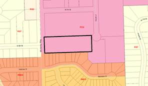
The Morgan Addition Final Plat will complete the platting of the 6th & Monterey Way Planned Commercial Development. (Figure 2) This property was shown as one lot on the previously approved Preliminary Development Plans, but is divided into two lots with the Preliminary Development Plan that was submitted concurrently with this Final Plat, PDP-15-00378.
|
|
|
Figure 2. 6th & Monterey Way Planned Commercial Development outlined. The highlighted areas are properties that have approved Final Plats. The subject property is marked with an X. |


The 6th and Monterey Way Preliminary Development Plan, which also serves as the preliminary plat, was originally submitted prior to the adoption of the 2006 Development Code. The Final Plat has been placed on the Planning Commission’s agenda for approval, per the process in the pre-2006 Code and will be forwarded to the City Commission for acceptance of dedication of easements and rights-of-way.
Street and Access
The property has frontage on Monterey Way, a public street, and Morgan Avenue, a private street on the north side of the property. The property abuts right-of-way for Comet Lane to the east. No access is proposed on Monterey Way. Direct access will be taken to the private street to the north, Morgan Avenue. The City Engineer recommends connection to Comet Lane; however, the City Commission prohibited this connection when they approved the Benefit District in 2000. Staff is requesting that this restriction be removed so Morgan Avenue can connect with Comet Lane to provide traffic circulation and connectivity through the area as well as provide an additional access for emergency vehicles.
Master Street Tree Plan
The Master Street Tree Plan and graphic includes the required number of trees along Monterey Way and shows them being located outside the utility easement. The Master Street Tree Plan should be revised with smaller species to accommodate the overhead power lines and to make minor technical changes.
Utilities and Infrastructure
The utilities and infrastructure being provided with the final plat coincide with the Preliminary Development Plan. The Preliminary Development Plan will be revised to meet the City Utilities specifications and the Final Plat will be revised to match, if necessary.
Public Improvements
Public improvements necessary for this project include the extension of sanitary sewer and water mains to serve the development. If the City Commission allows Morgan Avenue to connect to Comet Lane, the extension of Comet Lane and the associated sidewalk will also be a public improvement. Public Improvement Plans for these improvements must be submitted and approved and the means of assurance of completion of improvements (letter of credit, funds in escrow, etc.) prior to the recording of the final plat with the Register of Deeds.
Easements and Rights-of-Way
Easements are being dedicated as shown on the Preliminary Development Plan with the exception of the 20 ft utility easement adjacent to the Access Easement on the north side of the property. A 7.5 ft utility easement is shown on the Preliminary Development Plan. The Preliminary Development Plan will be revised to provide easements per the City Utilities Department’s approval and the easements on the final plat will be revised to match, if necessary.
Compliance with Preliminary Plat
The final plat conforms to the Preliminary Development Plan [PDP-15-00378] with the revisions to easements noted above.
Summary
The proposed subdivision is in conformance with the minimum lot area and dimension requirements for the Planned Commercial Development in the 1966 Zoning Ordinance. The final plat, as submitted, is consistent with the requirements of the subdivision regulations.