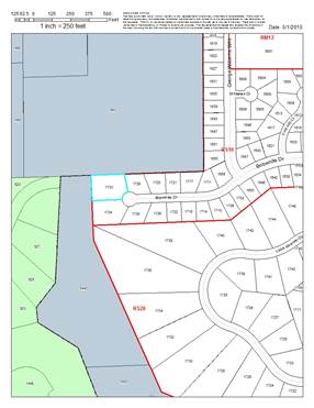
PF-15-00248: Final Plat for The
Reserve at Alvamar No. 4, a residential subdivision containing approximately
.903 acres, located at 1733 Bobwhite Drive and associated easements. Submitted
by LandPlan Engineering, for Christopher M. and Amanda M. Storm, property
owners of record.
ADMINISTRATIVE
DETERMINATION: The Planning Director approves the above-described Final
Plat based upon the certification in the body of this report with no
conditions.
KEY POINTS:
·
The property is zoned RS10 (Single-Dwelling Residential)
District. A Preliminary Plat (PP-15-00114), was approved by the Planning
Commission at their May 18, 2015 meeting.
SUBDIVISION CITATIONS TO
CONSIDER
This application is being
reviewed under the Subdivision Regulations for Lawrence and Unincorporated
Douglas County, effective Jan 1, 2007 as amended Jan 10, 2012.
ASSOCIATED CASES
·
PP-12-39-00: Preliminary Plat: The Reserve at Alvamar No. 3.
·
PF-03-06-01: Final Plat:
The Reserve at Alvamar No. 3 (Intersection of Bob White Dr. and George Williams
Way).
·
PP-15-00114: Preliminary
Plat: The Reserve at Alvamar No. 4.
·
FP-15-00249: Floodplain permit: In
Review.
OTHER ACTION REQUIRED
·
Placement of Final Plat on the City Commission agenda for
acceptance of dedications and vacations as shown on the Final Plat.
·
Recording of Final Plat with the Douglas County Register of Deeds
Office.
·
Application and release of Building Permit prior to development.
(The building permits will require review by the Fire Code Official to insure
the driveway is constructed to accommodate Fire Protection vehicles.)
PLANNING DIRECTOR
CERTIFICATION (Section 20-809(m)
The Final Plat conforms to the
content requirements of Section 20-809(m) of the Subdivision Regulations and is
consistent with the Preliminary Plat (PP-15-00114) approved by the Planning
Commission on May 18, 2015.
The Planning Director hereby
approves the Final Plat and certifies that the Final Plat:
a) Conforms to the Preliminary Plat previously approved by the
Planning Commission.
The Final Plat
conforms to the approved Preliminary Plat noted above.
b) Satisfies
any conditions of approval imposed by the Planning Commission.
The Planning
Commission approved the Preliminary Plat subject to conditions on May 18, 2015.
All of the conditions were in regard to site elements unrelated to platting and
have been met.
c) Includes
the same proposed dedications subject to minor technical adjustments as
described in Section 20-809(m)(2)(i)(a) through (d).
The Final Plat contains the same
dedications as the Preliminary Plat as follows:
·
Existing 10’ utility easements along the north and west boundary
of the property, as well as the utility easement along the street frontage of
Lot 1 and Tract A are to remain.
·
Drainage channels will be placed in the east portion of Lot 1 and
east portion of Tract A located in the designated drainage easement.
·
A drainage easement will be vacated and realigned to 10’ on the
eastern portion of the property. The vacation of this easement will be placed
on the City Commission meeting agenda on June 23, 2015.
·
The existing 50’ drainage easement to remain within Tract A.
d) Represents
a plat for which all required public improvements have been completed or for
which adequate guarantee of improvements has been provided.
Public
Improvement plans for utility main extensions and the construction of Bobwhite
Drive are already complete as per City approval prior to recording of this
Final Plat. A DSSA is required and has been submitted by the applicant and has
been approved by the Utilities Department for the utility service extensions to
Lot 1. Utility service to the lot will take place with development of a future
Single-Dwelling structure.
e) Is
otherwise consistent with the requirements of the Subdivision Regulations for a
Final Plat.
The Final Plat
is consistent with the requirements of the Subdivision Regulations.
STAFF REVIEW
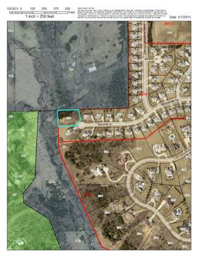
This property is located at the
west end of Bobwhite Drive, a City street. It is encumbered by the regulatory
floodplain but is not within the environs of a registered historic property.
The property is currently vacant. This plat will divide the tract into a lot
that will accommodate a single-dwelling structure and a tract that will retain
the existing drainage easement and contain the
regulatory floodplain. The intent is to create a buildable lot for a
single-dwelling structure and create a tract that will accommodate the
regulatory floodplain and drainage easement.
|
|
|
|
Figure 1a. Zoning in the
area. Subject property is outlined.
|
Figure 1b. Land use in
the area.
|
ACCESS
The resulting lot will take
access from Bobwhite Drive. The lot will have approximately 42 ft of frontage.
An important aspect of
subdivision design is insuring adequate access for Fire/Medical vehicles to the
structures. In order to create a buildable lot, a driveway must be installed
over the proposed drainage easement and drainage channel. This will result in a
long access driveway, which may exceed Fire Code distance requirements.
Appropriate fire access will be established with the review of a building permit for the future structure.
EASEMENTS AND RIGHTS-OF-WAY
The following easements are
provided on the plat:
·
Existing 10’ utility easements along the north and west boundary
of the property, as well as the utility easement along the street frontage of
Lot 1 and Tract A are to remain.
·
Drainage channels will be placed in the east portion of Lot 1 and
east portion of Tract A located in the designated drainage easement.
·
A drainage easement will be vacated and realigned to 10’ on the
eastern portion of the property. The vacation of this easement will be placed
on the City Commission meeting agenda on June 23, 2015.
·
The existing 50’ drainage easement to remain within Tract A.
Bobwhite Drive right-of-way width
is 60 ft. The subject property is located on the west side of a cul-de-sac at
the end of Bobwhite Dr. The cul-de-sac dimension is 100 ft. This final plat
does not propose any changes in right-of-way.
UTILITIES
A water main is located along the
frontage of the lot and tract and a service line will be located such that it
can serve Lot 1 from this line.
Sanitary sewer service will be
extended from the south to serve the new lot. The sanitary sewer main shown on
the plat in the utility easement along the south side of the tract will be
tapped for service and the service line will be routed through Tract A to the
lot. City Code requires the public main to touch each lot.
A variance has been requested from section 19-214(B) of the
city code which does not permit a private sanitary sewer service line to cross
any public right-of-way or drainage easement. This request was approved by the
City Manager on May 22, 2015.
MASTER STREET TREE PLAN
Street trees are required by Code
at a ratio of 1 tree per 40 ft of lot frontage. The property has 70 ft of
frontage along Bobwhite Drive which will require 2 street trees. One street
tree will be located in Lot 1 and one street tree will be located in Tract A. A
total of 2 street trees are listed in the Master Street Tree Plan.
CONCLUSION
The final plat
will divide and reconfigure the existing tract into one lot and one tract to
allow for the development of one new Detached Dwelling. With the noted
conditions, the final plat is in conformance with the standards and
requirements of the Subdivision Regulations and the Development Code.