|
PLANNING COMMISSION REPORT Regular Agenda -Public Hearing Item |
ITEM NO. 5B: PRELIMINARY DEVELOPMENT PLAN; .80 ACRES; 1043 INDIANA ST (LBZ)
PDP-7-1-11: Consider a Preliminary Development Plan to relocate the Varsity House and development of a Multi-Dwelling Structure, located at 1043 Indiana Street. Submitted by Paul Werner Architects, for Triple T LLC, property owner of record.
|
STAFF RECOMMENDATION:
Staff recommends approval of the following waiver and reduction: 1. Reduction of the front yard setback to 7’ on the north 50’ of the property.
Staff recommends approval of the Preliminary Development Plan for 1043 Indiana Street based on the findings presented in the staff report and forwarding it to the City Commission with a recommendation for approval subject to the following conditions:
ALTERNATE RECOMMENDATION If following the public hearing, the Planning Commission determines there are too many outstanding issues, the following alternate recommendation is provided:
The applicant will provide the necessary documents to complete the staff review. Staff will review the plans and make a final recommendation to the Planning Commission at the next Planning Commission meeting. |
|
Reason for Request: |
Development of a multi-dwelling residential project.
|
|
|
Attachments:
KEY POINTS · The property is located in the Oread Neighborhood Plan area. · The property is located in the environs of the Oread Historic District and the Michael D. Greenlee House, National Register of Historic Places. |
||
|
FACTORS TO CONSIDER · Conformance with the purpose of Planned Developments (Section 20-701, Development Code). · Compliance with Development Code. · Conformance with Horizon 2020. · Conformance with the Oread Neighborhood Plan · Conformance with Subdivision Regulations.
|
||
|
ASSOCIATED CASES/OTHER ACTION REQUIRED Cases requiring action · City Commission approval of Preliminary Development Plan. · Submittal of a Final Development Plan for approval and recordation at the Douglas County Register of Deeds Office. · Submittal and approval of public improvement plans. · Z-7-18-11 U-KU to RM32PD · DR-4-49-11 Design Review for 1043 Indiana Street · Submittal and approval of final plat.
PLANS AND STUDIES REQUIRED · Traffic Study – Received and accepted by staff. · Downstream Sanitary Sewer Analysis – Received and accepted by staff. · Drainage Study – Not submitted · Commercial Design Guidelines – Not applicable to this project.
|
||
|
PUBLIC COMMENT RECEIVED PRIOR TO PRINTING None received to date
|
||
|
General information |
||
|
Current Zoning and Land Use: |
U-KU (University-Kansas University) District, vacant structure and parking lot |
|
|
Surrounding Zoning and Land Use: |
North: RM32, multi-family, apartments South: RM32, multi-family, apartments East: U-KU, parking structure and University residence halls West: RM32, multi-family, apartments
|
|
Site Summary:
The request is for a single phase, multi-dwelling apartment building located on the west side of the 1000 block of Indiana Street. The project includes 5 1-bedroom apartments, 41 2-bedroom apartments, 4 3-bedroom apartments, a congregate residence with 6 bedrooms, a club room, 11,169 sf of public open space, and two levels of underground parking.
· Waiver 1. Reduction in the required front yard setback from 25’ to 7’ along the east property line. The majority of the structure is located 18’ from the east property line, but the relocated structure is only 7’ from the east property line. (The structure is 19’ from the property line but the substantial front porch is located 7’ from the property line.) The applicant has provided an analysis of the setbacks in the block to determine if the proposed setback is eligible for the exception identified in 20-602(e)(1). The average setback for this side of the street is 16.5’. This section of the code would allow the project to comply with the average front setback of the existing buildings. However, the reduction to 7’ is greater than the average allowed. Staff supports this waiver request as the majority of the building is behind the average setback and the reduced setback for the moved structure will help accentuate the structure as part of the development.
STAFF ANALYSIS
The property is located in the 1000 block of Indiana Street, lots 7-12 of Block 13 of Lane’s Second Addition to the City of Lawrence. Access to the development will be taken from Indiana Street and from the alley located mid block between Indiana Street and Mississippi Street. The subject property will be bounded by residential development to the west, north and south and with a parking structure located to the east.
The development proposal is for a Planned Residential Development containing the relocated Varsity House, approximately 3,800 sf, and a new apartment building of approximately 69,728 sf. The Varsity House will be utilized as a six bedroom congregate residence and will be relocated to what is now Lot 7. The apartment structure will contain a mix of one, two, and three bedroom units for a total of 50 units. Total units for the development will be 51 units.
The proposed Preliminary Development Plan for Varsity House to be located at 1043 Indiana Street has been evaluated based upon findings of fact and conclusions per Section 20-1304(d)(9) of the Development Code for the City of Lawrence, requiring consideration of the following nine items:
1) The Preliminary Development Plan’s consistency with the Comprehensive Plan of the City.
Staff finds that the proposal is in conformance with the comprehensive plan. Chapter Five – Residential Land Use identifies as the second strategy infill residential development. The fifth strategy for Residential Development identifies “The character and appearance of existing residential neighborhoods should be protected and enhanced. Infill development, rehabilitation or reconstruction should reflect architectural qualities and styles of existing neighborhoods.” The proposed project does reflect the architectural qualities and style elements of the existing neighborhood. The overall size of the proposed structure is atypical for the area, but other large apartment complexes do exist in the area.
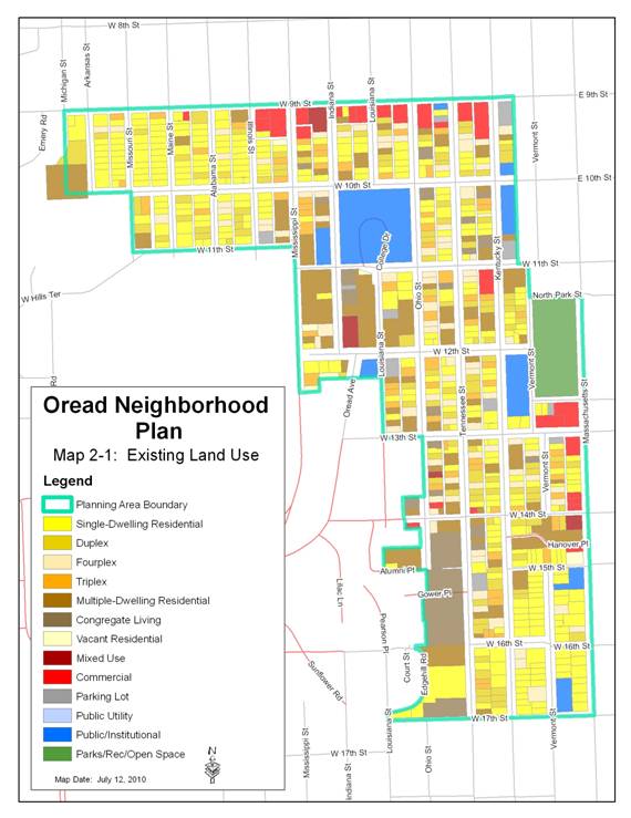
The Comprehensive Plan recommends that Development Proposals be reviewed for compatibility with existing land uses, including any neighborhood plan. (Policy 4.1, page 5-17) The subject property lies within the boundary of The Oread Neighborhood Plan that was adopted by the Lawrence City Commission on September 21, 2010. The Oread Neighborhood Plan (Chapter 14 – Specific Plans, Oread Neighborhood Plan) identifies this area on the Future Land Use map as High Density Residential.
The Oread Neighborhood Plan identifies goals, policies and implementation strategies for the area with outlines for future land uses and a long-term guide for urban development and redevelopment. According to the plan,
3.1.1 Goal 1 – Land Use
Maintain a variety of housing types to provide a balance in the diversity of people living in the neighborhood while maintaining strong neighborhood scale commercial areas.
3.1.1.1 Land Use Policies
E. New development should respect the historic integrity of the neighborhood.
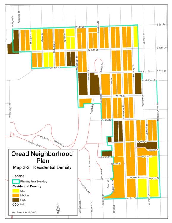
The future land use map for the Oread Neighborhood Plan identifies areas that are recommended for “High-Density Residential”. The intent of the high-density residential use is to allow for compact residential development at a density of more than 16 units per acre. The proposed project will utilize the density calculation identified in 20-701(f)(2)(ii). Using this calculated density, the proposed density of the project is 30.8 units per acre – high density.
The Oread Neighborhood Plan also identifies overlay districts for the plan area. District 2 (which includes the subject property) is designated to be a High-Density Overlay District that should develop and redevelop as high-density and mixed use. There are currently no overlay districts in place and no local design standards for new construction in this area.
The proposed project seeks to respect the historic integrity of the neighborhood by utilizing design techniques that attempt to reduce the overall scale and bulk of the new structure and using compatible materials and forms to help integrate the new structure into the neighborhood.
The Oread Neighborhood Plan also identifies goals, policies and implementation strategies for preservation.
3.1.2 Goal 2 - Preservation
Preserve and improve the character of the neighborhood by encouraging the preservation of existing historic structures and features and by supporting infill development that is compatible with the surrounding neighborhood.
3.1.2.1 Preservation Policies
A. Continue the preservation and protection of historic resources in the neighborhood.
B. Infill structures should be compatible with the massing, scale, and bulk of the historic structures in the surrounding area.
The proposed project does not preserve the existing historic structure on site in its original location. The proposed project will, however, rehabilitate the existing structure and move it to the north end of the site as opposed to demolishing the structure.
The proposed project is not compatible with the massing, scale, and bulk of the historic structures in the surrounding area. However, directly across the street from this proposed development is the parking structure for the multi-story residence halls that are adjacent to the east.
Staff Finding – The proposed development generally complies with the land use provisions found in Horizon 2020 and the Oread Neighborhood Plan. The proposed development may not comply with the preservation policies identified in the Oread Neighborhood Plan.
2) Preliminary Development Plan’s consistency with the Planned Development standards of Section 20-701 including the statement of purpose. (The statement of purpose of planned unit developments is found in Section 20-701(a) of the Development Code]
The purpose statement includes the following:
a) Ensure development that is consistent with the comprehensive plan. As discussed previously, the proposed development’s use, high density residential, is consistent with the comprehensive plan and the adopted plan for the area. The moving of the historic structure and the proposed one structure development may not meet the intent of the preservation and infill design characteristics defined in the Oread Neighborhood Plan.
b) Ensure that development can be conveniently, efficiently and economically served by existing and planned utilities and services.
The proposed infill development will utilize the existing public and private utilities that have been determined to be sufficient for the project. However, the City Stormwater Engineer indicated that the drainage study has not been submitted or approved for this project.
c) Allow design flexibility which results in greater public benefits than could be achieved using conventional zoning district regulations.
This area could develop as a conventional RM32 District. The benefit of requiring development through the planned development process is the ability to address the design of the site and the impact of the project on the existing features and neighborhood character at the preliminary plat stage (Preliminary Development Plan) and conserve as many of the character defining features as possible. An additional benefit for this project is the calculated density the PDP allows. This calculated density allows the applicant and the community the advantage of a higher residential density located adjacent to the University of Kansas.
d) Preserve environmental and historic resources.
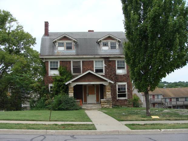
The existing structure located at 1043 Indiana Street was built in 1908 for Professor William Christian Hoad, a distinguished professor of Civil Engineering. Hoad was Assistant Professor, Associate Professor, and Professor of Civil Engineering and head of that department at the University of Kansas between 1900 and 1912. Hoad was also the Chief Engineer for the Kansas State Board of Public Health from 1907-1912. In this position, Hoad advised more than 200 Kansas cities and towns on public sanitation and initiated the 1907 law of sewage standards. Later, Hoad became the Professor of Municipal and Sanitary Engineering at the University of Michigan from 1912-1944. The structure located at 1043 Indiana Street is also significant for its architecture. The architectural style of the structure is a vernacular interpretation of the Shingle Style and the Dutch Colonial Revival style with some Craftsman style detailing. This type of architecture is not common in Lawrence with only a few examples still extant. While the structure located at 1043 Indiana Street is not currently listed in any historic register, it has been identified as eligible for listing in the National Register of Historic Places by the State Historic Preservation Office. Moving historic structures is not recommended by the National Park Service of the State Historic Preservation Office as it removes the structure from its historic context and creates an artifact without environs. The proposed project will move the existing structure and destroy its existing context. The applicant proposes the moving of the structure as a compromise from an earlier proposal to demolish the structure. The current proposal to move the structure will preserve some of the existing structure but will not preserve the structure and its context. (See attached historic resources report.)
|
|
|
Existing structure located at 1043 Indiana Street |
e) Promote attractive and functional residential, nonresidential, and mixed-use developments that are compatible with the character of the surrounding area.
The proposed development will provide an attractive and functional residential development. The applicant has worked with staff and the Architectural Review Committee of the Historic Resources Commission to identify design techniques to help make the structure more compatible with the historic character of the area. While the overall massing, bulk and scale of the project is large, the design details make this an attractive addition to the area.
Section 20-701(d) states that all of the standards of the Development Code apply to development within a PD District except as expressly authorized by regulations of Section 20-701.
The Minimum District Size identified in Section 20-701(c) is ½ acre. The proposed development meets this standard at 0.80 acre.
Section 20-701(f) identifies the Standards Eligible for Modification for the planned development. The Planning Commission shall recommend and the City Commission shall approve, a list of uses allowed in a Planned Development at the time of the preliminary approval. The only uses proposed for this development are residential multi-dwelling uses. The mix of one, two, and three bedroom dwelling units and the proposed congregate residence are all allowed in the base district RM32. The only other use will be the accessory use of a club house for the residences of the complex. Staff recommends the list of approved uses be the base district approved uses for the RM32 District.
The proposed development will be encompassing platted lots 7-12 of Lane’s Second Addition to the City of Lawrence. Because the development will be one large structure that crosses over all of the platted lot lines, and because the applicant is using setbacks as though this is one lot, Staff has determined that the property should be replatted into one lot. The replat of these six lots into one lot will aid the development to meet certain criteria established for utilities. This preliminary development plan should be used as the preliminary plat for the replatting process.
One of the advantages of the Planned Development for residential development, particularly infill development that is supported by the Comprehensive Plan, is the ability to modify the residential density by using the Density Calculation identified in Section 20-701(f)(3)(ii).
(ii) Density Calculation
For the purpose of calculating Net Density in Multi-Dwelling Structures, a studio or 1-bedroom unit shall count as .4 Dwelling Unit, a 2-bedroom shall count as .6 Dwelling Unit, a 3-bedroom unit shall count as .8 Dwelling Unit, and 4 or more bedroom units shall count as 1 Dwelling Unit. Minimum outdoor area, as required in Article 20-601(a), shall be met based on the total calculated Dwelling Unit count and not the actual number of Dwelling Units.
For this project, the applicant has identified
|
Dwelling Unit Types |
Actual # of Dwelling Units |
Calculated # of Dwelling Units |
# of Bedrooms |
Req. Outdoor Area (square feet) (Calc du * 50 sf) |
|
4 3-bedroom units (.8) |
4 |
4 * .8 = 3.2 |
4 * 3 = 12 |
3 * 50 = 150 sf |
|
41 2-bedroom units (.6) |
41 |
41 * .6 = 24.6 |
41 * 2 = 82 |
24.6 * 50 = 1,230 sf |
|
5 1-bedroom units (.4) |
5 |
5 * .4 = 2 |
5 * 1 = 5 |
2 * 50 = 100 sf |
|
1 Congregate Residence 6 bed rooms |
1 |
1 |
6 |
1 * 50 = 50 sf |
The calculated density of the project is 30.8 units per acre. The actual density for the project is 63 units per acre. The calculated density allows the actual number of bedrooms to be reflected in the open space and density requirements.
The minimum setback standards of the base district may be reduced by the City Commission provided that all exterior walls of detached buildings shall be separated by a minimum distance of 10 feet according to Section 20-701(f)(4). The applicant’s proposal meets all of the setback requirements of the base district and the 10’ separation of buildings except for the front yard setback. The applicant is requesting a reduction in front yard setback from 25’ to 7’ along the east property line. The majority of the structure is located 18’ from the east property line, but the relocated structure is only 7’ from the east property line. (The structure is 19’ from the property line but the substantial front porch, 18’ X 11’, is located 7’ from the property line.) The applicant has provided an analysis of the setbacks in the block to determine if the proposed setback is eligible for the exception identified in 20-602(e)(1). The average setback for this side of the street is 16.5’. This section of the code would allow the project to comply with the average front setback of the existing buildings. However, the reduction to 7’ is greater than the average allowed. Staff supports this waiver request as the majority of the building is behind the average setback and the reduced setback for the moved structure will help accentuate the structure as part of the development.
The proposed development contains a large four story structure with an undetermined height. Staff does not have current elevations that identify the height of the structure and cannot determine if a waiver is required for the overall height of the proposed development. The height limitation for the base RM32 district is 45’. In addition, the plan proposes retaining walls at the perimeter of the parking garage. Height has not been noted, therefore staff cannot determine if setback variances from the Board of Zoning Appeals may be necessary.
Balconies above the second story of a multi-dwelling unit building are prohibited along the exterior of a Planned Development unless the building setback is increased to at least double the required minimum setback and landscaping is enhanced with two or more of the following features: a minimum 4’ berm, a solid screening fence (6’ minimum Height) or a masonry wall (6’ minimum Height). This provision shall apply only to those exterior sides of a Planned Development that are adjacent to RS zoning or to detached Dwelling Units. The proposed project is adjacent to RM32 and U-KU districts and is not adjacent to detached dwelling units.
The parking for this proposed development is all located on site and underground. As such, it is not required to meet the landscaping requirements of the code. The proposed project is required to have 106 parking spaces with 5 accessible spaces. The total provided in the two level underground parking areas is 115 with five accessible spaces for a total of 120 spaces. These spaces are distributed between the two levels and are accessible through interior elevators. Bicycle parking is also provided at 1 per four spaces for a total of 28 spaces.
Planned Developments shall include at least 20% of the total site area as Common Open Space. 50% of the Common Open Space shall be developed as Recreational Open Space unless environmentally sensitive lands are present. Common open space identified on the drawing for this development plan is located on the ground floor with 9,869 sf and on the fourth floor as 1,300 sf for a total of 11,169. This meets the requirement of 20% of the total site area. However, the application does not identify where this open space is and what areas are identified as recreational open space.
Additional Requirements and standards for the planned development include the following:
Unified control – Two parcels are identified for the proposed project site. The owner of lots 7,8, and 9 is Thomas Fritzel and the owner of lots 10,11, and 12 is Triple T LLC. The applicant should verify that the proposed project site is under a single entity’s control.
Street access – The TIS for this project indicates that it will not generate 100 or more average daily trips. Therefore, access to a local street is compliant.
Sidewalks – 5’ sidewalks are required on Indiana Street and 11th Street. These sidewalks are shown on the plan.
Landscaping - The Landscaping and Screening standards of Article 10 apply to Planned Developments. In addition, any part of the development area not used for Buildings, Structures, Parking, Streets, or Accessways shall be landscaped with a sufficient mixture of grass, vegetative Ground Cover, trees, and Shrubs, except those areas designated to be preserved with natural vegetation.
Preservation of natural features – there are no identified natural features on the development site.
The proposed development, as conditioned, meets the standards for a Planned Development in Article 701, with waivers or modifications being requested. However, the applicant must provide additional information before Staff can verify compliance with all standards in the Development Code. The proposed development meets the minimum area requirement for a PD district. The requested modification will not negatively impact any nearby development or property owners.
Staff Finding – The proposed Preliminary Development Plan is substantially consistent with the Statement of Purpose of Planned Development. The proposed Preliminary Development Plan, as conditioned, is consistent with the standards of Section 20-701 of the Development Code with the exception of the front yard setback, and the applicant has requested a modification from the City Commission and a waiver from the Planning Commission from this standard.
3) The nature and extent of the common open space in the Planned Development.
The Development Code requires that a minimum of 20% of the site must be designated as common open space and of that 50% must be utilized as open recreation space. The plan identifies 35,153 sf of total land space with 9, 869 sf of public open space. This exceeds the 20% required space. The plan does not identify the 50% recreation space.
Staff Finding – The proposed Preliminary Development Plan provides common open space which exceeds that required by Code. The plan must designate the area that is being set aside as Common Open Space. The plan must designate the area that is being set aside as recreation space.
4) The reliability of the proposals for maintenance and conservation of the common open space.
A note placed on the Preliminary Development Plan addresses this issue.
Staff Finding – A note on the plan insures protection of the common open space.
5) The adequacy or inadequacy of the amount and function of the common open space in terms of the densities and dwelling types proposed in the plan.
The density of the entire site is 63 units per acre but the calculated density is 30.8 units per acre. The planned development may use the calculated density to determine the required amount of open space. The dwelling types are a mixture of one, two, and three bedroom units with one congregate six bedroom unit. The Development Code requires 50 sq. ft. of outdoor area that can be used for recreational purposes for each dwelling unit in a conventional RM32 District. The Code states that the required outdoor areas serves as an alternative to a large rear setback and is an important aspect in addressing the livability of a residential structure on a small lot. The development plan proposes 51 dwelling units. The Development Code would require 2,550 sq. ft., (51 x 50 sq. ft) of outdoor area to mitigate the small lot size in a conventional RM32 Zoning District. This development is being designed as a planned development and is required to have 20% of the site as common open space. The calculated density would require 1,530 sf of open space. 9, 869 sf of public open space is shown on the plan. The majority of this space is located in the front yard. Section 20-602(g)(2)(iii) does not permit area within the required front setback to be used for the required outdoor area. The plan also identifies a public open space on the fourth floor. Initial plans indicated that this was a type of recreation area. Final plans have not been submitted at this time.
Staff Finding – The amount and function of the common open space is adequate based on the overall density and the calculated density for residential uses. The dwelling types are an apartment building which will contain 50 dwelling units and the Varsity House that will contain a congregate residence with six occupants. The amount of open space being provided exceeds that required by the Development Code for the conventional RM32 District.
6) Whether the Preliminary Development Plan makes adequate provisions for public services, provides adequate control over vehicular traffic, and furthers the amenities of light and air, recreation and visual enjoyment.
The development is designed to utilize the existing public services with the exception of the storm water system. The applicant is working with the Stormwater Engineer to identify the public improvements that will be required for this portion of the project. A drainage study has not been submitted, reviewed, or approved. The underground parking provides adequate control over vehicular traffic on site. The large amount of common open space will provide ample light and air. There will be several opportunities for recreational enjoyment on the site. A club house area will be located on the fourth floor which will also provide a recreation area.
Staff Finding –The Preliminary Development Plan has made adequate provisions for public services and provides adequate control over vehicular traffic through limited access points. The plan furthers the amenities of light and air, recreation and visual enjoyment through the provision of common open space and open recreation space. A drainage study is required and should be submitted, reviewed and approved prior to the submission of the Final Development Plan.
7) Whether the plan will measurable and adversely impact development or conservation of the neighborhood area by:
a) doubling or more the traffic generated by the neighborhood;
The project includes the reconstruction of the alley between 10th and 11th Streets and the removal of the historic brick that currently exists in the alley. The proposed parking garage will have two access points on the new alley and one access point on Indiana Street. The TIS indicated that the development will generate less than 100 trips during the peak hours and does not warrant further study at this time.
b) proposing housing types, building heights or building massings that are incompatible with the established neighborhood pattern; or
The housing type and massing are not compatible with the established historic neighborhood pattern. The proposed structure is, however, compatible with the large apartment complexes that have been developed in the area since the 1970’s. Most of the residences in the area are two to two and a half stories. This structure is the equivalent to four stories. The only structures of this height in the area are the residence halls to the east and the Oread hotel to the south. The area is also mainly characterized with individual structures on individual lots. The proposed project is one large structure that sits on six platted lots. The existing structure that will be located to the north end of the project area is compatible with the size, scale, type and height of the overall character of the neighborhood.
c) increasing the residential density 34% or more above the density of adjacent residential properties.
The properties to the north, west, and south are zoned RM32 and the Oread Neighborhood Plan identifies this area as a mix of medium and high density with multi dwelling residential and congregate living being the dominate uses on the adjacent properties.
|
|
Subject Property |
Staff Finding –Staff has determined that the Preliminary Development Plan will not have measurable and adverse impact on the development or conservation of the neighborhood area. The density is similar to surrounding residential properties.
8) Whether potential adverse impacts have been mitigated to the maximum practical extent.
Potential adverse impacts to the historic character of the neighborhood by the size, bulk, mass and scale of the proposed new structure are possible. To mitigate these potential impacts, the applicant will relocate the existing structure to the north end of the development and has designed the new structure to have compatible materials and roof forms. The new structure will have projections in the main façade to create a rhythm affect that is suggestive of the historic development pattern of 50’ to 100’ lots.
Staff Finding –
The adverse impacts of the development will be addressed by architectural detailing that will help to minimize the bulk, mass and scale of the proposed new structure.
9) The sufficiency of the terms and conditions proposed to protect the interest of the public and the residents of the Planned Unit Development in the case of a plan that proposes development over a period of years.
Staff Finding- A phased development has not been proposed.
Staff Review and Conclusion
The project site is located in the Oread Neighborhood Plan area and is located in the environs of the Oread Historic District and the Michael D. Greenlee House, National Register of Historic Places. The proposed Preliminary Development Plan conforms to the anticipated land use for this area as stated in the Comprehensive Plan and the Oread Neighborhood Plan. The development will provide infill development for four currently vacant lots and will redevelop the two lots now encumbered by the existing house. Infill development is encouraged in the Comprehensive Plan and the Oread Neighborhood Plan. The applicant chooses to develop the southernmost area of the project site with the new construction of the large apartment structure. This allows the applicant the most advantageous construction staging for the underground parking area, the new structure, and the new foundation for the existing structure. As an alternative to demolishing the existing structure, the applicant proposes to move the existing structure to the north end of the project area. This area is adjacent to structures that have a similar form and mass. The Historic Resources Commission (HRC) will review this project at their meeting on August 18, 2011 to determine if moving the structure and the proposed new development will encroach upon, damage or destroy the environs of the Oread Historic District and the Michael D. Greenlee House. This determination will be made using the Standards and Guidelines for Evaluating the Effect of Projects on Environs as prescribed by the State Preservation Law 75-2724, as amended and K.A.R. 118-3-1—118-3-16.
While the HRC will make a determination based on the State Preservation Law, the Planning Commission must make a recommendation for the project based on the Comprehensive Plan including the Oread Neighborhood Plan. Both of these documents address infill development, preservation, and the importance of neighborhood character.
CONCLUSION:
Staff recommends approval of this proposed Preliminary Development Plan with the noted conditions.