![]()
LAWRENCE HISTORIC RESOURCES COMMISSION
ITEM NO. 3: DR-04-49-11, DR-7-103-11, PDP-7-1-11
STAFF REPORT
A. SUMMARY
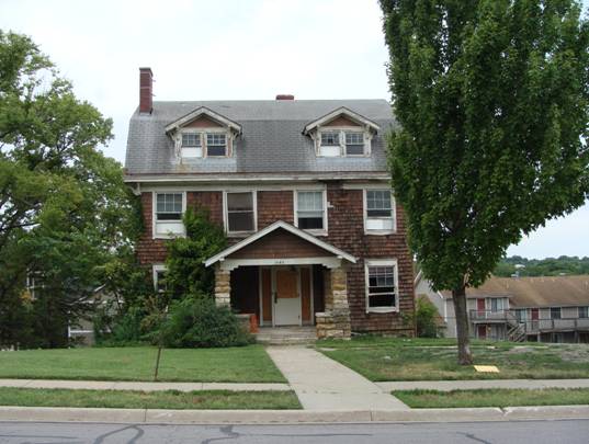
DR-04-49-11 DR-4-49-11, DR-7-103-11, PDP-7-1-11 1043 Indiana; Relocation and New Construction, Rezoning, and Development Plan; Certified Local Government Review. The property is in the environs of the Oread Historic District, National and Kansas Register of Historic Places. Submitted by Paul Werner Architects for Triple T LLC, property owner of record.
B. PROJECT DESCRIPTION
The applicant is requesting to move the existing historic structure located at 1043 Indiana Street to the north end of the vacant lots and incorporate the structure into a design for a multi-unit apartment building. Currently the property is zoned U-KU and is vacant. The applicant is requesting to rezone the property to RM32PD. THE APPLICANT SUBMITTED REVISED RENDERINGS AUGUST 10, 2011. IT IS ANTICIPATED THAT REVISED ELEVATIONS WILL BE SUBMITTED PRIOR TO THE MEETING.
|
|
|
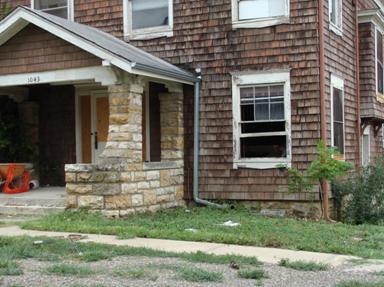
1043 Indiana Street on August 10, 2011 |
C. STANDARD FOR REVIEW
For Certified Local Government Review of projects within the environs of listed properties, the Historic Resources Commission has typically used the Standards and Guidelines for Evaluating the Effect of Projects on Environs to evaluate the proposed project. Therefore, the following standards apply to the proposed project:
1. The character of a historic property’s environs should be retained and preserved. The removal or alteration of distinctive buildings, structures, landscape features, spatial relationships, etc. that characterize the environs should be avoided.
2. The environs of a property should be used as it has historically been used or allow the inclusion of new uses that require minimal change to the environs’ distinctive materials, features, and spatial relationships.
4. Demolition of character-defining buildings, structures, landscape features, etc. in a historic property’s environs should be avoided. When the severity of deterioration requires removal within the environs, compatible reconstruction shall occur.
6. New additions, exterior alterations, infill construction, or related new construction should not destroy character-defining features or spatial relationships that characterize the environs of a property. The new work shall be compatible with the historic materials, character-defining features, size, scale and proportion, and massing of the environs.
|
ADDITIONS Recommended The scale of additions should not dominate the existing design patterns that characterize the environs of a listed property.
Additions should follow and/or be compatible with the patterns of setback, design, style, etc. that characterize the environs of the listed property.
Additions should be of the same material and/or compatible with the existing structure. |
Not Recommended Additions that dominate the existing structure and/or the environs of the listed property.
Additions that destroy relationships between character-defining features of the listed property’s environs.
Additions that are not compatible and/or typical of the patters, design, style etc. already established in the environs of a listed property.
Additions that obstruct important views and vistas for or to the listed property. |
|
PARKING Recommended When possible, maintain the parking patterns that characterize the environs of a listed property.
When new parking areas are required, design them to be consistent with the character of the environs and to intrude as little as possible.
|
Not Recommended Wholesale modification of traditional, character-defining parking patterns.
Creation of new parking areas that are incompatible and/or inconsistent with the parking patterns that characterize the environs. |
|
NEW / INFILL CONSTRUCTION Recommended New construction should relate to the setback, size, form, patterns, textures, materials and color of the features that characterize the environs of the listed property.
Where there are inconsistent setbacks or varied patterns, the new construction should fall within the range of typical setbacks and patterns in the environs of the listed property. |
Not Recommended New construction that is inconsistent and/or incompatible with the character of the environs of the listed property.
New construction that destroys existing relationships within the environs of a listed property.
New construction that dominates the environs.
New construction that obstructs views or vistas from or to the listed property. |
|
ZONING Recommended Maintain zoning that continues the histories land use in the environs of a listed property.
When rezoning is required within the environs of a listed property, the impact of the rezoning should be considered and steps taken to mitigate adverse effects.
When replatting is necessary, all subsequent new construction should be compatible with the environs in relationship to the setbacks, form, size, scale massing, etc.
|
Not Recommended Rezoning to allow development that is incompatible and/or inconsistent with the character of the environs.
Speculative or spot zoning without a well-defined use for the property that is compatible with the environs.
Any rezoning without design documents indicating the compatibility of the proposed new use, addition, and/or infill construction.
Replatting to facilitate new construction that is incompatible and/or inconsistent with the character of the environs of a listed property. |
D. STAFF ANALYSIS
HISTORY
For a full history of the structure located at 1043 Indiana, please visit http://www.lawrenceks.org/planning/documents/hrcagendaJuly11Full.pdf.
The structure located at 1043 Indiana Street was constructed in 1908.The architect for the structure has not been verified, but available information indicates the structure was designed by William Alexander Griffith or Harriet Tanner. The architectural style of the structure is a vernacular interpretation of an amalgamation of the Shingle Style and the Dutch Colonial Revival style with some Craftsman style detailing.
The structure located at 1043 Indiana Street was built for Professor William Christian Hoad, a distinguished professor of Civil Engineering. WC Hoad was born in Lecompton, KS on January 11, 1874 and died in 1962. Hoad was Assistant Professor, Associate Professor, and Professor of Civil Engineering and head of that department at the University of Kansas between 1900 and 1912. Hoad was also the Chief Engineer for the Kansas State Board of Public Health from 1907-1912. In this position, Hoad advised more than 200 Kansas cities and towns on public sanitation and initiated the 1907 law of sewage standards. Later, Hoad became the Professor of Municipal and Sanitary Engineering at the University of Michigan from 1912-1944.
1043 Indiana Street was converted to fraternity use by 1920. The demand for housing in Lawrence after WWII was perhaps even greater than in other areas because of the significant increase in enrollment at the University of Kansas. By 1950 KU had purchased the property and used it to house various departments. It was most notably known as the residence hall for varsity football players during the 1950s called Jock’s Niche.
As part of the South of Memorial Stadium Survey, Hernly and Associates requested a preliminary determination of eligibility for the National Register of Historic Places from the State Historic Preservation Office for 1043 Indiana Street. The National Register Coordinator responded to the request (see attached) and agreed with Hernly’s assessment that the structure is potentially eligible for inclusion in the National Register of Historic Places – either as part of a potential historic district or individually. The SHPO was of the opinion 1043 Indiana Street is individually eligible under Criterion C for its architecture and perhaps under Criterion A for its social history.
ENVIRONS
“Environs,” as defined by the Standards and Guidelines for Evaluating the Effect of Projects on Environs, means the historic property’s associated surroundings and the elements or conditions which serve to characterize a specific place, neighborhood, district, or area. In an environs review the objective is to determine the impact of a proposed project on a listed property and its environs.
Like the treatments for historic properties, guidance for environs review begins with the identification of the character-defining features of the environs, its historic and current character, and what must be retained in order to preserve that character. The character of a listed property’s environs may be defined by form; exterior materials such as masonry, wood or metal; exterior features and elements such as roofs, porches, windows or construction details; as well as size, scale and proportion, massing, spatial relationships, etc.
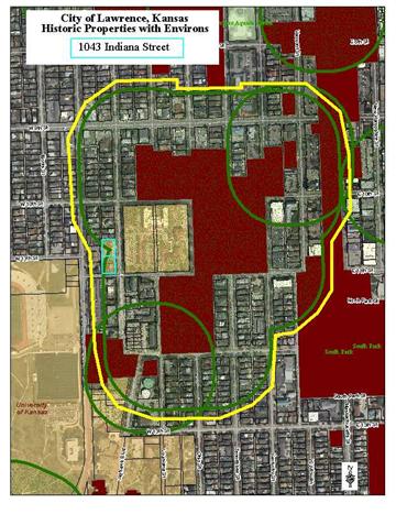
The property located at 1043 Indiana Street is located in the environs of the Oread Historic District, National Register of Historic Places. (The property directly to the north, identified on the City GIS system as 1000 Blk #1 is located in the environs of the Michael D. Greenlee House at 947 Louisiana Street as well as the Oread Historic District, National Register of Historic Places.) Historically, this area of the environs of the Oread Historic District developed with a combination of large houses on multiple lots and standard size houses on single lots. The 1918 Sanborn Fire Insurance Map shows that 1043 Indiana was a Fraternity and the lot to the north was vacant. Old College in the center of what is labeled University Park is directly to the east where the housing pattern appears more developed with most lots supporting structure by 1918. In 1918 it also appears that the area to the north of the 1000 Block of Indiana and Old College had developed with a mix of smaller and moderate size dwellings. To the west of the 1000 Block of Indiana Street, Mississippi Street appears to be developing with moderate size houses on individual lots. The alley is used for accessory access with accompanying structures. Interestingly, several of the structures are identified as “auto” on the 1918 map.
The National Register Nomination for the Oread Historic District defines why the area was nominated and accepted for listing. The neighborhood is significant for its contribution to the community planning and development of Lawrence, for having architecture that is representative of the period of development and for its association with significant people in Lawrence and the world of architecture. The period of significant is 1863-1929. The materials commonly found in the district are limestone, concrete, brick, wood, stone and asbestos. Setback and lot size are also a common feature. According to the Kansas Historic Society, “environs means the historic property’s associated surroundings”. Environs do change over time; however, the purpose of environs review in accordance with the State Preservation Law is to insulate the historic property or district from encroachment of inappropriate development.
The size of the dwelling units as noted on the Sanborn maps varies from 1 to 2 ½ with Old College being the dominant structure in the area. Typical lot sizes are the platted 50’ lot with some lot and ½ and a few 100’ double lots. Setbacks vary in the area, but all clearly have a front yard, side yards and a rear yard. The structures facing Indiana Street in the 1000 block appear to be placed closer to the street, possibly because of the topography of the area. The historic materials identified for the area are predominately wood frame structures with wood sheathing but brick is also used as a building material in the environs. Historically, roofs had some pitch and were often simple gabled or hipped forms. 1043 Indiana is fairly unique with its gambrel roof form. Porches are clearly a dominate feature for the environs and are shown on almost all of the dwellings noted on the Sanborn maps. As noted above, automobiles are part of the historic environs of this area as identified by the “auto” accessory structures located on the alley.
The structure located at 1043 Indiana Street is not currently listed in the Kansas or National Register of Historic Places, but as noted above, the structure is eligible for listing and would be eligible for the financial incentives for rehabilitation associated with listing. The subject structure is located in the outermost area of the notification boundary for the Oread Historic District. There is a line of site, although limited by topography, from the listed property, the Oread Historic District.
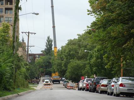
Looking north on Indiana from 10th Street
MOVING THE HISTORIC STRUCTURE
As presented, the plan of moving the historic structure does not appear to meet the Standards and Guidelines for Evaluating the Effect of Projects on Environs, specifically standards
1. The character of a historic property’s environs should be retained and preserved. The removal or alteration of distinctive buildings, structures, landscape features, spatial relationships, etc. that characterize the environs should be avoided.
The applicant proposes the rehabilitation of the existing structure located at 1043 Indiana. As part of the rehabilitation, the structure will be moved to the north end of Lot 7. (The new apartment complex will be constructed on Lots 7-12.) As part of the move, the addition, basement, and chimney will be lost. The chimney can be rebuilt; and the applicant proposes to use the stone from the foundation to face the foundation at the new location. The existing rear (west) addition of the structure is in poor condition and is causing some damage to the original structure. Staff is in agreement with the applicant that this addition should be removed or replaced.
The National Park Service has very stringent guidelines on moving historic structures and their ability to maintain or achieve listing in the National Register. The applicant has requested a determination from the SHPO regarding whether the structure located at 1043 Indiana Street would remain eligible for listing if it is moved to the north of the development property. The SHPO (see attached) has responded that the structure would not be eligible for listing in the National Register and listing in the Register of Historic Kansas Places would require the applicant to work with the SHPO on the move and might not achieve register listing because of the loss of integrity associated with the move. According to the National Register publication How to Apply the National Register Criteria for Evaluation,
The National Register criteria limit the consideration of moved properties because significance is embodied in locations and settings as well as in the properties themselves. Moving a property destroys the relationships between the property and its surroundings and destroys associations with historic events and persons. A move may also cause the loss of historic features such as landscaping, foundations, and chimneys, as well as loss of the potential for associated archeological deposits.
One of the basic purposes of the National Register is to encourage the preservation of historic properties as living parts of their communities. In keeping with this purpose, it is not usual to list artificial groupings of buildings that have been created for purposes of interpretation, protection, or maintenance. Moving buildings to such a grouping destroys the integrity of location and setting, and can create a false sense of historic development.
The National Register criteria for evaluation highlight the importance of a structure’s location and setting. While the history of the structure located at 1043 Indiana Street is significant, it does not enter into the evaluation of the move of the structure under State Preservation Law as part of this development project. The question for the HRC is: will the move of the structure and the subsequent development encroach upon, damage, or destroy the environs of the Oread Historic District and the Michael D. Greenlee House. The National Register information on evaluation is relevant in that it shows the importance of location and setting for historic properties. While moving the structure to the north, both to save it and to group it with “like” buildings is preferable to demolition; staff is concerned about the possible creation of a false sense of streetscape and development of the block, as well as the loss of the association of the structure with the prominent corner lot.
 In the application
materials, the applicant identifies the reason for proceeding with a plan to
move the structure is that it ultimately makes the most sense for the building.
Keeping the structure where it is or moving it slightly to the south to
maintain its presence on the corner would require moving the house two times,
once to rebuild the foundation and again to put the house back on the new
foundation. This plan also eliminates the ability for parking underneath. Moving
the structure to the north will cause it to be moved only once. It will also provide
the opportunity to reuse the foundation materials to face the new foundation
and include underground parking under the new foundation.
In the application
materials, the applicant identifies the reason for proceeding with a plan to
move the structure is that it ultimately makes the most sense for the building.
Keeping the structure where it is or moving it slightly to the south to
maintain its presence on the corner would require moving the house two times,
once to rebuild the foundation and again to put the house back on the new
foundation. This plan also eliminates the ability for parking underneath. Moving
the structure to the north will cause it to be moved only once. It will also provide
the opportunity to reuse the foundation materials to face the new foundation
and include underground parking under the new foundation.
![]() It is the
opinion of staff that moving the structure located at 1043 Indiana will
encroach upon, damage and destroy the environs of the Oread Historic District.
Staff does note that the western edge of the environs of the Oread District has
already been damaged by modern infill redevelopment. What developed as a single
family neighborhood has been altered. However, according to the Oread
Neighborhood Plan, 31% of the acres are still used for single family dwelling.
It is the
opinion of staff that moving the structure located at 1043 Indiana will
encroach upon, damage and destroy the environs of the Oread Historic District.
Staff does note that the western edge of the environs of the Oread District has
already been damaged by modern infill redevelopment. What developed as a single
family neighborhood has been altered. However, according to the Oread
Neighborhood Plan, 31% of the acres are still used for single family dwelling.
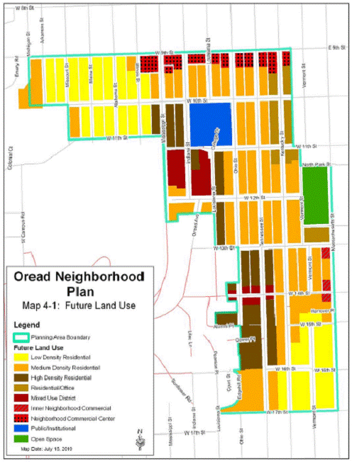
The map to the left shows the district and its environs (outlined in yellow). As noted by the map, the environs encompasses a much larger area than just the 1000 block of Indiana. It is important to consider the environs as a whole. To further destroy the environs with the loss of this significant structure and its associated location and setting does not meet the applicable standards.
There are options available to the applicant to avoid this determination that the project does not meet the standards and will encroach upon, damage, or destroy the environs of the Oread Historic District. The structure at 1043 Indiana could be rehabilitated on its current site and incorporated into a new apartment development. The western portion of Lots 11 and 12 could be used for the new development while maintaining the green space and existing structure as a focal point for the development. This project could be a great asset to the community by blending the historic character of the environs and the existing structure with the new development.
Staff is of the opinion the structure located at 1043 Indiana Street is a character defining feature of the environs of the Oread Historic District. Reasons the structure is character defining include the prominent location of the structure on two lots, architectural style, and continuance of the historic patterns of the neighborhood including but not limited to setbacks, green space, and building materials. As mentioned above, the move of the structure will alter not only the building location, but also the structure by removal of the basement, chimney, and addition. Using the Standards and Guidelines for Evaluating the Effect of Projects on Environs, it is staff’s opinion that while preferable to demolition, the moving of the structure does not meet the intent of Standard 1.
1. The character of a historic property’s environs should be retained and preserved. The removal or alteration of distinctive buildings, structures, landscape features, spatial relationships, etc. that characterize the environs should be avoided.
It is the opinion of staff that the proposal of moving the historic and potentially eligible structure at 1043 Indiana Street does encroach, damage or destroy the environs of the Oread Historic District and the Michael Greenlee House at 947 Louisiana Street and does not meet the Standards and Guidelines for Evaluating the Effect of Projects on Environs. In accordance with the Standards and Guidelines for Evaluating the Effect of Projects on Environs, the standard of evaluation, staff recommends the Commission deny the proposed project.
Staff additionally recommends that the applicant secure the building from further damage and intrusion and to prevent public harm. There are many broken windows and ways to enter the structure without permission.
If the members of the HRC rule that moving 1043 Indiana does NOT encroach, damage or destroy the environs, the following is the review of the proposed new infill construction:
NEW CONSTRUCTION
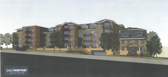
The applicant proposes to construct a new apartment complex on Lots 7-12 Block 13 Lane’s Second Addition. As of August 15, 2011, complete architectural drawings and elevations that correspond with the submitted renderings have not been received by the Planning Department.
As presented, the plan does not appear to meet the Standards and Guidelines for Evaluating the Effect of Projects on Environs, specifically standards
2. The environs of a property should be used as it has historically been used or allow the inclusion of new uses that require minimal change to the environs’ distinctive materials, features, and spatial relationships.
6. New additions, exterior alterations, infill construction, or related new construction should not destroy character-defining features or spatial relationships that characterize the environs of a property. The new work shall be compatible with the historic materials, character-defining features, size, scale and proportion, and massing of the environs.
Standard #2
Standard #2 states, “The environs of a property should be used as it has historically been used or allow the inclusion of new uses that require minimal change to the environs’ distinctive materials, features, and spatial relationships.”
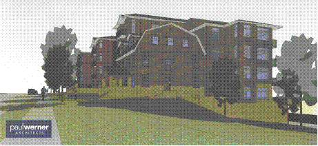
![]() In the Oread
Neighborhood Plan, the 1000 block of Indiana is planned as high density residential
development. The rezoning of this property to RM32 and the accompanying
building fit with the long-term plan set forth in the Oread Neighborhood Plan.
The use and density is not the problem for this project.
In the Oread
Neighborhood Plan, the 1000 block of Indiana is planned as high density residential
development. The rezoning of this property to RM32 and the accompanying
building fit with the long-term plan set forth in the Oread Neighborhood Plan.
The use and density is not the problem for this project.
In the Oread District, parking structures are not common and are not a historic use. For this project, the underground parking consists of two levels that are not connected to each other. Level 1 has access from Indiana Street. Level 2 has access from the alleyway off 11th Street. Both entries have a metal gate restricting access to residents. The west elevation has two levels of openings for the garage levels, which carry to the north and south elevations. The openings will have a green screen covering. While underground parking structures are not common, they are less intrusive to the environs of listed properties. Staff prefers underground parking to surface lots. The proposed materials and design for the parking structure portion of this project, particularly the entrance with the large retaining wall off of Indiana Street, appear to emphasize the existence of the underground parking as opposed to making the parking structure appear minimal.
Though the higher density use has been mentioned in long term planning, the change in lots 7-12 would be more than “minimal”, as pertains to spatial relationships in the Standards. As further discussed below, the materials and features are less affected by the change.
Standard #6
This review is based on the HRC’s approval to move the historic structure. Doing so eliminates #6a, “New additions, exterior alterations, infill construction, or related new construction should not destroy character-defining features or spatial relationships that characterize the environs of a property.”
The following considers #6b, “The new work shall be compatible with the historic materials, character-defining features, size, scale and proportion, and massing of the environs.”
Compliance with standards:
 The
applicant has worked diligently with the Architectural Review Committee to minimize
the impact of the proposed structure to the environs through the use of
building materials, roof forms, and a main façade that has variation in depth.
The proposed structure incorporates features that are found in the historic
neighborhood and the environs of the Oread Historic District and the Greenlee
House. There are sections that are setback from the front façade presenting an
undulating building. The roofline shares characteristics of those found in the
environs with the choice of a pyramidal roof and
dormers. The chosen materials are similar to those typically used in the
environs. The ground floor is covered in rough stone and the upper stories
alternate between wood shingles, cement lap siding and brick.
The
applicant has worked diligently with the Architectural Review Committee to minimize
the impact of the proposed structure to the environs through the use of
building materials, roof forms, and a main façade that has variation in depth.
The proposed structure incorporates features that are found in the historic
neighborhood and the environs of the Oread Historic District and the Greenlee
House. There are sections that are setback from the front façade presenting an
undulating building. The roofline shares characteristics of those found in the
environs with the choice of a pyramidal roof and
dormers. The chosen materials are similar to those typically used in the
environs. The ground floor is covered in rough stone and the upper stories
alternate between wood shingles, cement lap siding and brick.
Staff has concerns about the overuse of the rusticated stone. Within the environs of the Oread Historic District stone is typically used only for basement materials and accent (there are small vernacular structures of stone in the area). Staff would suggest limiting the height of the rough stone so it does not dominate the pedestrian level, as it appears in the renderings. As seen in the photo, stone is only used on the porch and basement, just above ground level. Staff recommends keeping this pattern throughout the overall project design.
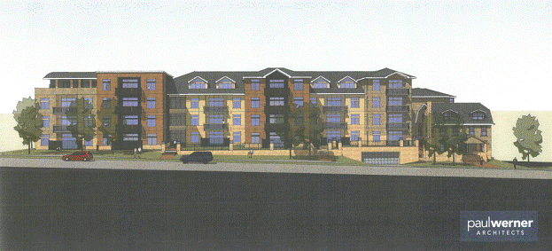
The north elevation best illustrates how the new construction will relate to the historic structure. It shows new construction that works to relate to the moved structure and its surroundings. The various rooflines on the proposed structure are similar to other dwellings in the environs. The infill structure tries to not tower over the historic structure and steps down to relate to its neighbors. This is a large apartment building in an area that has previously only seen small apartment buildings 2-3 stories tall.
North Elevation
Issues to address:
The typical rhythm and development pattern of the area is single structures on single or double lots. The proposed renderings address the feature of the environs by breaking up the façade with recessed glass entryways. In the north elevation above, it does read as separated buildings. Staff would still like to see the building further broken up with more green space in the 50 to 100 foot pattern of the environs.
On all sides of the façade are balconies with railings of perforated aluminum and painted steel. Balconies are not common in the environs. The free standing structures typically have front porches and back patios. Occasionally there will be a second floor balcony/porch where a sleeping porch would have been. Even then, those porches are made of stone and wood. The materials portrayed in the renderings do not match those in the neighborhood. Staff is of the opinion that, though not consistent with the environs, the inclusion of balconies in the proposed design increases the residential feel of the project.
The windows on the proposed building don’t read as residential windows. The casement window with a horizontal crossbar on the top third of the windows does not fit the environs where most windows would be double hung. Additionally, the windows in the new construction are larger than most in the residential environs.
CONCLUSION
Infill construction in historic neighborhoods is very difficult. One has to avoid creating a false history or creating something that does not relate to its surroundings. Preservation is not meant to stop the march of time, but to engage the best of the past and present to create responsible design. The proposed infill project, though not perfect has made great strides to relate to its surroundings. The choice of materials and the way the façade and roofline have been broken up helps the building fit in the environs. However, the architectural detailing, while aiding to minimize the impact of the large structure, cannot correct the overall size, mass and scale issues of the project.
E. STAFF RECOMMENDATION
Proposed Project of New Construction and Moving the Existing Structure – DR-04-49-11 PDP-7-1-11
In accordance with the Standards and Guidelines for Evaluating the Effect of Projects on Environs, the standard of evaluation, staff recommends the Commission deny the proposed project and make the determination that the proposed project does encroach upon, damage, or destroy the environs of one or more listed historic properties. Specifically, the project does not meet the following standards:
1. The character of a historic property’s environs should be retained and preserved. The removal or alteration of distinctive buildings, structures, landscape features, spatial relationships, etc. that characterize the environs should be avoided.
2. The environs of a property should be used as it has historically been used or allow the inclusion of new uses that require minimal change to the environs’ distinctive materials, features, and spatial relationships.
4. Demolition of character-defining buildings, structures, landscape features, etc. in a historic property’s environs should be avoided. When the severity of deterioration requires removal within the environs, compatible reconstruction shall occur.
6. New additions, exterior alterations, infill construction, or related new construction should not destroy character-defining features or spatial relationships that characterize the environs of a property. The new work shall be compatible with the historic materials, character-defining features, size, scale and proportion, and massing of the environs.
ZONING DR-7-103-11
In accordance with the Standards and Guidelines for Evaluating the Effect of Projects on Environs, the standard of evaluation, staff recommends the Commission approve the proposed project and make the determination that the proposed project does not encroach upon, damage, or destroy the environs of one or more listed historic properties with the following conditions:
- Any changes to the approved plans should be resubmitted to the Historic Resources Commission prior to the commencement of any related work.