|
PLANNING COMMISSION REPORT NON-PUBLIC HEARING ITEM |
PC Staff Report
9/26/11
|
ITEM NO 3b:
|
PRELIMINARY PLAT; Inverness Park Plaza Addition No. 5, a replat of Lot 1, Block 1, Inverness Park Plaza Addition No. 1. |
|
PP-7-7-11: Consider a Preliminary Plat for a Replat of Lot 1, Block 1, Inverness Park Plaza Addition No. 1, for a two lot commercial development, located at 3900 W 24th Place. Submitted by Landplan Engineering, for Corporate Holdings II, LLC, property owner of record Hy-Vee, Inc contract purchaser.
|
|
|
STAFF RECOMMENDATION: Staff recommends approval of the Preliminary Plat of Inverness Park Plaza Addition No. 5, a replat of Lot 1, Block 1, Inverness Park Plaza Addition No. 1 and forwarding it to the City Commission for consideration of acceptance of easements and rights-of-way; subject to the following condition:
1. Provision of a revised Preliminary Plat to show the vacated easement along Crossgate Drive and the 10’ pedestrian easement with dimensions. |
|
Applicant’s Reason for Request: to accommodate proposed commercial development.
KEY POINTS
· Preliminary plat proposes re-division of single lot into two lots.
· Development is intended for commercial development.
· Plat includes request to allow direct access to Crossgate Drive.
SUBDIVISION CITATIONS TO CONSIDER
· This application is being reviewed under the Subdivision Regulations for Lawrence and Unincorporated Douglas County, effective Jan 1, 2007.
· Section 20-810(a)(2)(i) requires subdivisions to comply with all applicable zoning district standards.
ASSOCIATED CASES
· Z-7-21-11; RSO to CN2.
· SUP-7-4-11; Gas and Fuel Sales, Food & Beverage Sales and accessory Car Wash (Cleaning).
· PF-7-4-11; Final Plat submitted concurrently with Preliminary Plat.
OTHER ACTION REQUIRED
· City Commission acceptance of easements and rights-of-way as shown on the Preliminary Plat.
· Submission and approval of applicable public improvement plans.
· Final Plat administrative review, approval, and recording at Register of Deeds Office.
· Building permits prior to construction activity.
PLANS AND STUDIES REQUIRED
· Traffic Study –Study provided.
· Downstream Sanitary Sewer Analysis – Study submitted and accepted.
· Drainage Study – A drainage study is not required for this project because downstream flooding is confined to the regulatory floodplain. [Stormwater Management Criteria Section 1.6.E.2.a].
· Retail Market Study – Not required for development less than 50,000 SF.
PUBLIC COMMENT RECEIVED PRIOR TO PRINTING
· None to date
ATTACHMENTS
· Preliminary Plat
|
Current Zoning and Land Use: |
RSO (Single-Dwelling Residential-Office) District; undeveloped land. [Proposed rezoning to CN2-Z-07-21-11].
|
|
Surrounding Zoning and Land Use:
|
RM15 (Multi-Dwelling Residential) District) to the west; Remington Square – [Proposed rezoning to RM24; Z-8-12-10].
RM12 (Multi-Dwelling Residential) District to the north; Existing apartment development known as Parkway 4000.
PUD (Alvamar Planned Unit Development) to the northeast; existing apartment development.
RM24 (Multi-Dwelling Residential) District to the east; existing apartment development known as Lorimar Apartments.
RSO (Single-Dwelling Residential) District to the south; undeveloped lot. |
SITE SUMMARY
Total area: 3.324 acres
Lot 1: 2.73 acres
Lot 2: .594 acres
Request includes proposal to remove access restriction to Crossgate Drive and dedicate an interior access easement. No additional right-of-way is proposed by the applicant. However, a right-turn lane is proposed along southbound Crossgate Drive in the existing right-of-way. This improvement would widen the street and relocate the public sidewalk to a pedestrian easement.
STAFF REVIEW
The Preliminary Plat shows a proposed division of a single lot into two separate lots both adjacent to public right-of-way. Access to the lots is intended to be shared via the use of an internal access drive (easement). The property is located on the southwest corner of Clinton Parkway and Crossgate Drive. The property is bordered on the north by Clinton Parkway, an arterial street, on the east by Crossgate Drive, a collector street, and on the south by W 24th Place, a local street. The original plat included an access restriction that prohibits direct access to Crossgate Drive and Clinton Parkway.
Zoning and Land Use
The property is currently undeveloped. The purpose of the proposed zoning change and the Preliminary Plat is to create commercial lots for development. Specifically, development of a gas convenience store with car wash is proposed. The west side of the property is encumbered by the regulatory floodplain. As such a local floodplain development permit will be required for development of this property. The applicant has been advised of this requirement. The permit is an administrative review item and does not require Planning Commission action.
Streets and Access
- This revised Preliminary Plat retains the existing grid street formation originally established for the area.
- Clinton Parkway is an existing arterial street. Direct access to this street is not proposed.
- Crossgate Drive is an existing collector street.
- W24th Place is an existing local street.
- The project includes the construction of a right-turn lane southbound from Clinton Parkway to the site. This requires relocating the public sidewalk to an easement for a portion of the site.
The previous approval included a plat restriction that prohibits direct access from lots to the abutting arterial and collector streets. Approval of this request would modify that provision and allow for an access drive to Crossgate Drive. A traffic study was provided by the applicant. This study is required as part of the Subdivision Plat and Special Use Permit application process. The study identifies the level of service of some parts of the Clinton Parkway/Crossgate Drive intersection as “D” indicating that there are current delays. The plan concludes that the overall consequence of the development is a minimal change to the existing level of service at the intersection. The abutting streets were designed to accommodate the existing and projected traffic in terms of volume.
The proposed Driveway intersection is located 160’ from the north property line and approximately 215’ south of the south curbline of Clinton Parkway. The Development Code establishes minimum spacing standards for driveways from signalized intersections. All driveways intersecting a collector street shall be separated at least 300’ from a signalized intersection and 250’ from other non-signalized intersections (section 20-915 (e)(2)). In this specific application the driveway would be located within the functional area of both the signal at Clinton Parkway and Crossgate Drive and the roundabout intersection of Crossgate Drive and W 24th Place. The proposed driveway intersection is intended to optimize the spacing between the two intersections along this segment of Clinton Parkway.
The Development Code grants authority to the City Engineer to waive the spacing requirements. Such actions must be reported to the Planning Commission. If the Planning commission approves a break in the access restriction for Crossgate Drive the City Engineer is prepared to address the waiver request.
Discussion Item
The impact of removing the access restriction to Crossgate Drive and allowing either full access or some form of restricted access for the property is a significant issue to be considered.
Crossgate Drive is a collector street. A collector street is defined in Section 20-815 (d) of the Subdivision Regulations, as:
Street, Collector: A collector street provides for land access and traffic circulation within and between residential neighborhoods and commercial and industrial areas. They distribute traffic movements from these areas to the arterial streets. Collector streets do not typically accommodate long through trips and are not continuous for long distances.
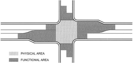
The applicant’s traffic study submitted for the Preliminary Plat addresses the basic requirements for the subdivision. The study assessed the impact on the roadway and the need for specific improvements that would result from the proposed development. The study identified intersection functional areas where driveway intersections onto Crossgate Drive are undesirable as they interfere with the safe and efficient operations of the intersections. The figure below highlights the areas that require special consideration. The proposed access is located outside of the “functional area” noted in the study so that it should not interfere with the signal operations.
|
Area for
proposed driveway outside of physical and functional areas of
intersection. |
The new access is shown more than 200’ south of the Clinton Parkway curb line. The study, however, does not discuss access conflict points related to specific turn movements. Left turn movements are the most critical consideration of access design because of the accident potential. Right turn movements, properly designed with deceleration and turn lanes are less critical.
From a transportation system management perspective, the ideal condition for the protection of the road network is to retain the access restriction on Crossgate and access the site from W 24th Place. This preliminary plat application represents a request for full access allowing all legal turn movements (right in/right out and left in/left out) entering and exiting the site. Full access allows all right and left turn movements into and out of the site. Alternatives to full access include from the least desirable to the most desirable:
1. Allow ¾ access restriction (allows right in, right out, and left out, but not left in movements). Requires a median on Crossgate Drive.
2. Allow Right In/Right Out access (does not allow any left turn movements). Requires a median on Crossgate Drive.
3. Allow Right In Only.
4. Retain access restriction (no driveway cut to Crossgate Drive)
The attached diagrams show the various options for full access and restricted access as well as the impact on the neighborhood.
City Staff recognizes the change in land use designation with the initial approval of the Inverness Park District Plan. Staff supports the removal of the current plat restriction to allow limited access from and to Crossgate Drive. Staff believes that the most efficient and least conflicted access to accommodate the use is a right-in/right-out movement and construction of an extended center median on Crossgate Drive. This would minimize the additional conflict points generated by the proposed uses on Crossgate Drive, but would permit full access at 24th Place, allowing vehicles to move west or east to the intersection at Inverness Drive or Crossgate Drive and then to turn either north or south from there. While a right-in/right-out access point creates the least traffic conflict points, the City Engineer would accept a ¾ access point for the uses currently requested in the accompanying SUP application as a compromise to the applicant’s request for full access on Crossgate Drive. Procedurally, any waiver must be reported to the Planning Commission and any party aggrieved may appeal the action of the City Engineer within 14 days of the Planning Commission meeting at which the item appears on the agenda.
Utilities and Infrastructure
The property currently has access to public sewer and water service. Infrastructure planning previously completed anticipated development of this property. The existing sanitary sewer main does not extend to touch proposed Lot 2. Extension of the main will be required to serve both lots. A new utility easement is proposed to accommodate the extended sanitary sewer line.
Easements and Rights-of-way
This request does not alter the width of the right-of-way but does include a right turn lane on the southbound leg of Crossgate Drive. The plat has been revised to provide a pedestrian easement to accommodate the relocated sidewalk along Crossgate Drive. The existing 15’ utility easement parallel to Crossgate Drive is not needed and would conflict with the placement of street trees. The easement will be vacated and replaced with a 10’ pedestrian/utility easement along Crossgate Drive.
Summary
The proposed plat complies with the design standards of the Subdivision Regulations with the exception of the driveway separation from a signalized and non-signalized intersection. Approval of the proposed Preliminary Plat includes lifting access control to Crossgate Drive in order to allow the City Engineer to make a determination on waiving the driveway spacing standards for the proposed and future uses.
STAFF RECOMMENDATION
This Preliminary Plat conforms to the standards and requirements of the subdivision regulations and the land use plans for the area as noted in the body of the staff report. Staff recommends approval of the Preliminary Plat.