|
PLANNING COMMISSION REPORT Regular Agenda – Non Public Hearing Item |
|
ITEM NO. 14A ANNEXATION OF 69 ACRES; SOUTHWEST CORNER OF N 1800 ROAD AND E 1000 ROAD (SLD)
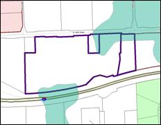
A-3-1-11: Consider an annexation request for approximately 69 acres, located on the south side of N 1800 Rd (Farmers Turnpike) and between the extended alignments of E 900 Rd and E 950 Rd. Submitted by Steven Rothwell, Timothy W. and Lani S. Rothwell, for Timothy Rothwell, Wilber C. Rothwell, and Donald Kenna Rothwell, property owners of record.
|
|
|
STAFF RECOMMENDATION:
Staff recommends that the Planning Commission forward a recommendation to the County Commission that they find that the annexation will not hinder or prevent the proper growth and development of the area or that of any other incorporated city located within the Douglas County and that the annexation is compatible with Horizon 2020 and the K-10 and Farmer’s Turnpike Plan and;
Staff recommends that the Planning Commission recommend approval and forward the recommendation to the City Commission for the approval of the requested annexation of approximately 69 acres located on the south side of N 1800 Road (Farmer’s Turnpike) and between the extended alignments of E 900 Road and E 950 Road subject to the following conditions:
1. Building permits may be issued for the property if the City of Lawrence reasonably determines that either City water or City sanitary sewer service is not required to serve the use or uses on the property, the uses being those that can be served by rural water or on-site sanitary sewer management systems (including, but not limited to sewage storage tanks). 2. The applicant shall execute an agreement not to protest the future annexation of any adjacent rights of way or roadway easements. |
|
|
Reason for Request: |
“This property is in the urban growth area of Lawrence. It is designated for industrial uses in Horizon 2020 and the K-10/Farmer’s Turnpike Plan. It is adjacent to a large tract of land with industrial zoning and is bounded by Kansas Turnpike, the Farmer’s Turnpike, and a recently annexed property with industrial zoning, making it an excellent location for an industrial site. |
KEY POINTS
· April 5, 2011, City Commission received annexation request.
o Requests more than 10 acres are referred to the Planning Commission for a recommendation.
· This request includes approximately 69 acres to allow for industrial development.
· The property is located within the Lawrence Urban Growth Area.
· This request is accompanied by a rezoning request for IG (Z-3-8-11).
COMPREHENSIVE PLAN FACTORS TO CONSIDER
· Horizon 2020 – Chapter 4, Growth Management
· Horizon 2020 – Chapter 7, Industrial Development
· Horizon 2020 – Chapter 8 Transportation
· Horizon 2020 – Chapter 14 Specific Plans
· Sector Plan – K-10 and Farmer’s Turnpike Plan
ASSOCIATED CASES OR OTHER ACTION REQUIRED
· After City Commission receives the Planning Commission’s recommendation concerning the annexation request, City Commission may consider passing a resolution requesting the Douglas County Board of County Commissioners make a finding pursuant to state statute that, “the annexation will not hinder or prevent the proper growth and development of the area or that of any other incorporated city located within the county.”
· The Board of County Commission will consider the City’s request to make the necessary findings, if appropriate and notify the City of its decision.
· Adoption by City Commission of an ordinance annexing the property.
· Notice to Rural Water District No. 6 of the City’s intent to annex.
o City Commission authorized the City Manager to provide notice of the City’s intent to annex the land to Rural Water District No. 6 on April 12, 2011.
o Notice mailed to RWD No. 6 on April 21, 2011.
· Approval by City Commission and publication of Z-3-8-11 (A-1 to IG).
· Subdivision approval required as a pre-development step.
· Site plan approval required as a pre-development step.
PLANS AND STUDIES REQUIRED
· Traffic Study – Not required at this time.
· Downstream Sanitary Sewer Analysis – Not required at this time. End user required for analysis
· Drainage Study – Not required at this time.
· Retail Market Study – Not required at this time.
ATTACHMENTS
· Area map
· Memo to City Commission – annexation referral
· Staff memo regarding notice to Rural Water District No. 6
· Land use map – K-10 and Farmer’s Turnpike Sector Plan
PUBLIC COMMENT RECEIVED PRIOR TO PRINTING
· Phone call from area property owners requesting additional information regarding the proposed request and development plans for the area.
EXISTING CONDITIONS
|
Current Zoning and Land Use: |
County A (Agricultural) District; existing agricultural fields and rural residences.
|
|
Surrounding Zoning and Land Use: |
To the north; A (Agricultural) District; existing agricultural fields and residences.
To the northwest; IG (General Industrial) District with use restrictions; undeveloped land.
|
|
To the south: A (Agricultural) District; I-70 highway and existing agricultural fields and residences south of highway.
To the southeast; A-1 (Suburban Home Residential) District; Oak Ridge Estates Subdivision. Includes developed and undeveloped residential lots and Morningstar Christian Church.
|
|
|
To the east; IG (Industrial General) District; existing agricultural field.
|
|
|
To the west; A (Agricultural) District; existing agricultural fields and residences. |
Site Summary
Gross Area: 69 acres
Area Requested for Annexation: 69 acres
Urban Growth Area: Service Area 4 as identified in Horizon 2020.
Project Summary:
This request is for industrial development. Annexation is a pre-development step.
Annexation Procedure
Kansas Law [12-519 et seq.] provides for annexation by ordinance of the City Commission. Lawrence City policy requires the Lawrence-Douglas County Metropolitan Planning Commission to review and make recommendations on all annexation requests in excess of ten acres. Upon annexation, the property is required to be rezoned to a compatible City zoning district. This request is accompanied by a rezoning application for IG. Annexation is a separate and distinct action from that of the rezoning consideration.
Because this property is not adjacent to the city “proper” it is considered an “island” annexation. Additional requirements for this type of annexation include County Commission consideration and determination that the proposed annexation, “will not hinder or prevent the proper growth and development of the area or that of any other incorporated city located within the county.” This action is required prior to the passage and publication of an ordinance by the City annexing the property. Additionally, notice of the City’s intent to annex the land, along with its plan for the provision of water service to the land being annexed is required to be sent to the Rural Water District serving the property not less than 60 days prior to the effective date of an annexation ordinance.
The subject properties are currently served by Rural Water District No. 6. Kansas Statutes require the city to purchase the property, facilities, and improvements, if any, of the district if the City designates a different water supplier to the land proposed to be annexed. The possibility exists that the site will continue to be served by Rural Water District No. 6 or another water supplier prior to the City of Lawrence extending city water service to the site.
The City of Lawrence Administrative Annexation Policy (AP-74) requires that the costs associated with compensation to a Rural Water District be paid to the City by the annexation applicant for Rural Water District facilities serving the property to be annexed.
General Location and Site Characteristics:
The property is located on the south side of N 1800 Road (Farmer’s Turnpike). The property is bounded along the south side by the I-70 Kansas Turnpike. The property is adjacent to another island annexation parcel along the east property line.
· The property includes a rural residence on each of the three parcels that makes up the combined 69 acres.
· The area is currently farmed and includes an area with vegetation along the low lying drainage areas of the site.
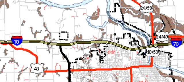
· The property is located within the existing Lawrence Urban Growth Area and approximately 1/2 mile east of the Lecompton-K-10/I-70 interchange.
The property is currently zoned county A (Agricultural). This same zoning is located on the south side of the Kansas Turnpike. A platted residential subdivision and an existing church are located south of the Turnpike, southeast of the proposed annexation. Scattered rural residences can also be found along the County roads in the vicinity of the property.
The property slopes from the east and the west toward a low lying area through the central wooded portion of the 69 acres. The average slope across the proposed annexation is less than 6 %. There no regulatory floodplain that encumbers the proposed annexation.
Horizon 2020 recognizes the importance of high-quality agricultural land and that it is a finite resource. Within Douglas County the soils classified as Class I and II are referred to as the capability class (Chapter 7 Horizon 2020.) This site includes a portion of Class II soils along the south side of N 1800 Road along the eastern portion of the property and an area along the south property line on the western portion of the property. This annexation request includes approximately 7.8 acres of Class II soils on the subject property.
|
|
|
Locations of sites of 20 acres or more with Class I and II soils in Douglas County. Subject area shown with arrow. |


While the subject property contains Class II soils, the soils are isolated and in small amounts relative to areas where significant contiguous amounts exist in Douglas County, such as are found in Grant Township. When weighing the goal of protection of Class II soils for this specific location against the transportation system and the criteria that supports industrial land use, the property is well suited for industrial development.
Infrastructure and Utility Extensions
This section of the report addresses the existing and future utility infrastructure serving this site. This property is located in the unincorporated area of Douglas County. Development of the property requires extension of municipal City services or development of an interim service plan.
Sanitary Sewer
Sanitary sewer is not currently extended to this property. Such extension is necessary to support urban development. Details regarding the end user or users are required to assess downstream impacts on the utility. A specific development proposal has not been submitted.
The city is engaged in updating the Wastewater Master Plan. This study is not yet complete. Basic land use was provided to the Utility Department for the study based on the recently adopted K-10 and Farmer’s Turnpike Plan. Anticipated uses include industrial development. This broad land use designation does not necessarily convey a specific amount of generated wastewater because data is use specific.
|
|
Items for consideration of public sanitary sewer service include the following: · City initiated master plan update anticipated completion of study by end of 2011 · Option for single user vs. multiple users o Waive code standards to accommodate rural type development for temporary time period. This would allow some type of on-site treatment. The method of disposal would depend on the amount to be managed. o Coordination with the County Health Department and or KDHE regarding on-site management options.
|
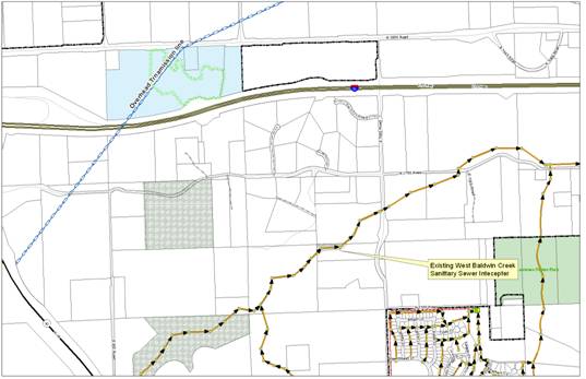
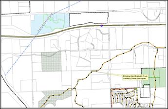 Proximity to Sanitary Sewer
While an interim plan may be feasible for a single user, such a plan may not be appropriate for multiple users. A specific study of the watershed will be required to assess impacts on the current municipal system and evaluate designated capital improvement projects that may be affected by development. Extensions of sanitary sewer mains are required for urban development. Approval of sanitary sewer public improvement plans are typically a requirement of the subdivision process.
Water
Extensions of water mains and adequate fire flow are required for urban development. Existing urban service is over one mile from the subject property. Rural Water District No. 6 has a facility located along N 1800 Road. Rural Water District No. 1 has a line located along N 1750 Road to the south of the property. (See page 2-7 K-10 and Farmer’s Turnpike Plan)
The City’s plan for providing water service to the properties is to permit Rural Water District No. 6 to provide water service to the annexed area. The City could amend its current contract with Rural Water District No. 6 to supply the rural water district with additional water, if the rural water district deems it necessary for it to provide the 69 acres of land with adequate water. If Rural Water District No. 6 is unwilling to supply the property with water at the service level required by the property owner, or if the City and District cannot agree to a contract for the provision of additional water from the City, the City will designate a different water supplier. Rural Water District No. 1 may be amenable to supplying water to the area proposed to be annexed.
|
|
· Option for single user vs. multiple users. · Quality of service for long run with single user. · Synergy of development required to generate sufficient demand for service and to maintain quality. o Waive code standards to accommodate rural type development for temporary time period. This would allow a rural water district to provide service to the annexed area. Amend current contract to assure available quantity of water available for development. This could include modifications to the existing agreements between the rural water district and the city regarding water supply |
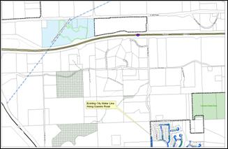 Proximity to City Water
While an interim plan may be feasible for a single user, such a plan may not be appropriate for multiple users. A specific study of the water demand will be required to assess impacts on the current municipal system and evaluate designated capital improvement projects that may be affected by future development. Extensions of water mains are required for urban development. Approval of water line public improvement plans are typically a requirement of the subdivision process.
Stormwater
The property includes natural drainage ways across the property that flows generally from the north to the south. Regional detention is recommended for each watershed as areas develop. No such plan has been developed for this area at this time. Approval of stormwater public improvement plans are typically a requirement of the subdivision process.
Items for consideration of stormwater management include the following:
· Regional Detention with development application.
· Easements for stormwater conveyance.
· Submission of a drainage study to assess the downstream impact.
· Assessment of the drainage structure at I-70 on the south side of the property.
Public Rights-of-way
This segment of N 1800 Road is also a designated principal arterial street. This designation will impact dedication of rights-of-way, access, and spacing with future development applications. The property is located within the vicinity of the I-70/K-10 interchange. Transportation 2030 identifies N 1800 Road as a Lawrence minor gateway. As such, special attention will be merited during the development phases of the property to assure compliance with applicable design standards. Width of right-of-way along with necessary access control and geometric improvement considerations are typically assessed as part of the subdivision and site plan development processes.
Items for consideration of public streets and roads include the following:
· Future improvements to I-70 within existing right-of-way.
· Road Maintenance N 1800 Road, including snow removal.
· Geometric improvements with development.
· Access control with development.
· Dedication of ROW with subdivision platting process.
· Submission and review of a traffic impact study.
Development of the area would include an assessment of roadway improvements abutting the property. Dual naming of such boundary line roads, maintaining both county and city names, for addressing purposes may be necessary for those properties outside of the annexation boundary.
No additional right-of-way needs are anticipated by the Kansas Turnpike Authority for future widening projects in this area. Additional review will be provided with subdivision plats and site plans for the property in the future.
Internal circulation and access to the abutting road and properties will need to be addressed with a specific development proposal. A traffic impact study will be required to evaluate proposed access options, separation requirements, geometric improvements, and similar items both internally and as development relates to the surrounding road network. No direct access is permitted to arterial roads, per the Land Development Code, unless the City Engineer grants a waiver from this requirement which would be necessary given that the property is bounded by a designated arterial road. A specific development plan has not been submitted to assess the full scope of transportation issues for this property. Street intersection spacing will be critical as the area develops and should be designed initially for best efficiency.
Emergency Responses Services
Key services include 911, fire protection, and police protection. The site is currently served by the County-wide 911 emergency medical response. Building addressing and street naming, as well as coordination of services between the City, County, and township providers, will be required and continuously reviewed throughout the development process.
Fire protection will depend on the proposed use, construction type, and available fire suppression systems for the site. Fire protection is also related to the availability of a municipal supply of water or some type of on-site storage device, to meet a minimum threshold. Similar requests to the east and northwest of this site proposed an on-site water tower to aid in fire protection. This same method could be considered depending on the end user of this site. Assessment of services and fire protection will be required as part of a specific development proposal. Limited services to the site may limit future development in terms of size or intensity dependent upon the end user or users of the site.
Items for consideration of emergency responses include the following:
· Adequate fire protection.
· Single user vs. multiple users.
Private utilities (Electric, gas, phone, etc)
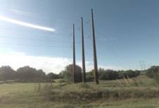
Electric, phone and gas extensions will be made to this property as it develops. Specific development proposals are needed to determine service requirements for a specific user. Utility providers have been made aware of the proposed request. Westar provided the following comments during the review: Only 1-phase service exists in this area. The closest 3-phase line is 1.5 miles east of E 950 Road. If this is a large industrial user, depending on load, upgrade to the 3-phase line (bigger wires) may be needed which would then be 2.5 miles east of E 950 Road. Generally the property can be served by private utility providers. A large transmission line extends from the southwest to the northeast through this area.
|
|

School facilities
The property is located in the Perry Lecompton school district (USD 343). The school district has been advised of this request.
COMPREHENSIVE PLAN:
Several chapters of Horizon 2020 are applicable to this review. These include Growth Management, Industrial and Employment-Related Land Use, and Transportation. Additionally, the property is within the boundary of the K-10 and Farmer’s Turnpike Plan.
Horizon 2020 – Chapter 4 Growth Management
Per map 3-1 in Chapter 3 of Horizon 2020, the General Plan Overview, and outlined in Chapter 4, Growth Management, the property is located within the Lawrence Urban Growth Area. Specific land uses for the area are identified in the K-10 and Farmer’s Turnpike Plan. Growth management policies address the need to evaluate the development with respect to the provision of services, protection of topographic and drainage features, and applicable land use criteria. Horizon 2020 gives priority to properties that abut existing city limits and to voluntary annexation.
Horizon 2020 allows for the initiation of development within Service Areas, 2, 3, and 4 prior to the full build-out of Service Area 1 when wastewater capacity is clearly available; a plan for interim development for the provision of rights-of-way and easements is complete; and when comparable build-out of Service Area 1 has been addressed.
- The property does not abut existing city limits except that it is adjacent to another island annexation along the east property line.
- This request is within the Urban Growth Area and represents a voluntary request.
- Urban services are not currently available to this site.
Horizon 2020 also gives priority to developments that are consistent with adopted utility plans. General policies related to growth management address the need to evaluate the proposed development with respect to the provision of services, protection of topographic and drainage features and with respect to land use criteria. Additional detail is needed to assess these elements including a sanitary sewer impact study, service delivery plan for water and other utility extensions and public services such as fire protection. Additional information is needed regarding the extension of any interior street network to service this property. Reasonable options exist to address all of these elements as development progresses.
Horizon 2020 – Chapter 7 Industrial and Employment-Related Land Use
Existing: A key strategy related to industrial development states:
Increase community involvement in economic development activities, by partnering with the local business community and area educational institutions to bring new technology and investment to the region for the purpose of meeting the economic development job growth goal of securing twenty thousand new jobs in Douglas County by 2020.
Approval of this request facilitates opportunities for industrial development consistent with adopted plans.
Chapter 7 includes a discussion of industrial development for the I-70/K-10 area. The adopted K-10 and Farmer’s Turnpike Plan has been amended into Horizon 2020 and includes the area as a future industrial site. A key strategy in Horizon 2020 supports the development and increase in the number and diversity of jobs for the entire community (Douglas County as a whole).
Chapter 7 brings together the importance of the natural environment and a diversified economy as a tool for development consideration. A feature of the plan states:
Encourage site availability, site improvements, and community amenities which best respond to the market demands for industrial and business development while maintaining the community objectives for the type and quality of such development.
Specific location criteria are included in Chapter 7. The plan has been updated to reflect the changes affected by the adoption of the K-10 and Farmer’s Turnpike Plan. The proposed annexation request is located within the revised I-70/ K-10 description for new industrial areas.
The proposed request complies with the locational requirements outlined in Chapter 7 including location within the UGA, feasible access to highway networks, and adequate size of land, outside of the regulatory floodplain and has an average slope of less than 6%.
Horizon 2020 – Chapter 8 Transportation
The transportation chapter provides goals and policies related to development. This chapter recognizes the relationship of transportation to land use planning. The plan acknowledges the importance of pedestrian and bicycle access as modes of transportation. Multi-modal transportation (rail and air), as well as ground transportation, are design elements considered with development applications. More detail about transit recommendations is contained in Transportation 2030. A key feature of both plans is the balancing of land use, transportation, and environmental needs. N 1800 Road is a designated gateway. This will necessitate additional review as part of the plat and site plan process to assure quality development consistent with plan recommendations.
Goals addressing multi-use trails, sidewalks, and alternative modes of transportation will be implemented with specific development proposals. The requirements for traffic impact studies at the site specific level and the larger planning area are needed to identify necessary capital improvements to serve the surrounding area as it develops. Assessment of land use will both predict and prescribe appropriate types of access needs.
Detailed plans are needed to implement transportation goals and policies listed in Horizon 2020. The proximity of the property to highways and arterial streets provide opportunities to develop the property with higher intensity uses that both need and can be served by excellent access.
- The Transportation Plan notes long-term plans for widening I-70 from 4 lanes to 6 within the existing right-of-way.
K-10 and Farmer’s Turnpike Plan
This sector plan was adopted and published in 2009. The plan includes the subject property and designates the area as suitable for industrial development. Goals and policies of the plan support development that promotes additional employment opportunities and tax base expansion. The plan recommends development to urban densities while taking care to respect and protect the natural features currently in place in the area as a whole.
Industrial development is intended for, “moderate to high-impact uses including large scale or specialized industrial uses geared toward utilizing K-10 Highway and I-70 for materials transportation.”
Policies for development specifically address property along N 1800 Road. The plan states: Structures along N 1800 Road (Farmer’s Turnpike) should present a front face to N 1800 Road to add to the high quality aesthetics encouraged in the gateway.
The plan further addresses gateway treatments, access, and circulation depending on the traffic generated and the size of land involved in a development proposal. These criteria will be further evaluated with future development applications for a specific user.
Summary Finding of Comprehensive Plan Review: This request is consistent with recommendations regarding future industrial development in the area. This request is consistent with recommendations that development occur within designated urban growth areas. The lack of available sewer and water service limits development opportunities for the property in the immediate future unless specific agreements for alternate service can be made.
DISCUSSION OF LAND USE AND REQUEST:
Annexation is an initial step of the development process. It is clear that development will be limited by the services available to support an end user. Additional agreements and approval must be executed regarding water supply and wastewater disposal.
Horizon 2020 supports a definitive approach that utility services and major street improvements should be in place prior to development. Significant municipal utilities must be extended to serve this area to support urban development.
Growth management is defined in Horizon 2020 as the primary tool for ensuring timely and orderly growth. This tool includes establishment of an Urban Growth Area, service delivery areas and specific annexation policies. It is expected that the service delivery areas defined in Horizon 2020 will be revised following consideration of the water and wastewater master plans update that have been engaged for the community.
Annexation Policy No. 1 states that the, “City of Lawrence will actively seek voluntary annexation of land within the Urban Growth Area as development is proposed.” The subject property is not immediately contiguous to existing main portions of the city limits. Contiguity, as recommended per Annexation Policy No. 2, is provided in that this property is adjacent to property annexed to the east. The Comprehensive Plan supports a proactive annexation plan that ensures adequate facilities and services. The Plan specifically recommends annexation of “areas which are needed to complete sewer or water line extensions for a closed (looped) system” per Growth Management Goal 3, Policy 3.2.a. The proposed request is inconsistent with this recommendation for annexation. Progressive annexation from existing boundaries northward is needed to fully comply with this recommendation. It should be recognized that some industrial uses can exist without City infrastructure and that adequate urban facilities and services could be provided if deemed necessary and if made a priority by the governing body.
The subject property is located within City of Lawrence Urban Growth Area. Horizon 2020 supports the provision of adequate facilities and services or assurances of adequate facilities in connection with development. Public and private utilities must be extended and/or upgraded to serve this area. Sanitary sewer, water, off-site stormwater, and roadway improvements need to be identified and planned for extension and improvement for both the short term and long term delivery.
It is important to note that other policies, mostly contained in Chapter 7 (Industrial and Employment-Related Land Use) support the subject site as a key industrial site in the City’s future. Staff recognizes that while it will take time and effort to provide utility and other infrastructure to the general area, there is opportunity to plan for and permit some amount of development in the area so that any new construction meets the City’s code requirements. This ensures that when the area does develop to urban densities, it more seamlessly fits into the urban pattern. The I-70 interchange and surrounding area will be an important economic generator for the region and planning today for its eventual build-out is appropriate and valuable.
CONCLUSION
Horizon 2020 and the K-10 and Farmer’s Turnpike Plan address land uses, infrastructure, transportation and other development opportunities for the area. Weighing all the policies, Horizon 2020 and the K-10 and Farmer’s Turnpike Plan support this request.
The development of the subject property requires consideration of adequate timing of providing the necessary infrastructure for basic utilities such as water and wastewater. Development of an interim plan for services, such as continued use of rural water and on-site wastewater disposal, would be required to serve development in the short term and is feasible and prudent for certain industrial uses. Such a plan should be tied directly to specific uses for development to mitigate potential harm to the surrounding area and to assure that adequate provisions are provided for integrating the development into the ultimate system when appropriate. This interim proposal may be sufficient to support a single user. Such a system will need to be assessed for multiple users.
Staff recommends that the Planning Commission forward a recommendation to the County Commission that they find that the annexation will not hinder or prevent the proper growth and development of the area or that of any other incorporated city located within the Douglas County and that the annexation is compatible with Horizon 2020 and the K-10 and Farmer’s Turnpike Plan and;
Staff recommends that the Planning Commission recommend approval and forward the recommendation to the City Commission for the approval of the requested annexation of approximately 69 acres located on the south side of N 1800 Road (Farmer’s Turnpike) and between the extended alignments of E 900 Road and E 950 Road subject to the following conditions:
1. Building permits may be issued for the property if the City of Lawrence reasonably determines that either City water or City sanitary sewer service is not required to serve the use or uses on the property, the uses being those that can be served by rural water or on-site sanitary sewer management systems (including, but not limited to sewage storage tanks).
2. The applicant shall execute an agreement not to protest the future annexation of any adjacent rights of way or roadway easements.