PLANNING COMMISSION REPORT
Regular Agenda – Public Hearing Item
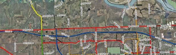
ITEM NO. 6B: A-1 TO IG; 51.13 ACRES; SOUTH OF N 1800 ROAD & WEST OF E 1000 ROAD (SLD)
Z-9-13-10: Consider a request to rezone approximately 51.13 acres from County A-1 (Suburban Home Residential) to City IG (General Industrial), located on the southwest corner of N 1800 Road (Farmer’s Turnpike) and E 1000 Road (Queens Extended). Submitted by Venture Properties, Inc., property owner of record.
|
STAFF RECOMMENDATION: Staff recommends approval of the rezoning request for 51.13 acres from County A-1 (Suburban Home Residential) to City IG (General Industrial) District and forwarding it to the City Commission with a recommendation for approval based on the findings of fact found in the body of the staff report. |
Applicant’s reason for request: “This site is designated for industrial land use in Horizon 2020 and the K-10 & Farmer’s Turnpike Plan that have been adopted by the Lawrence City Commission and the Douglas County Commission. This site has recently been reviewed by the City and county staff and a potential industrial user very favorably.”
KEY POINTS
· Sector plan identifies property as suitable for industrial development.
· The property has immediate access to an improved arterial streets and close proximity to the I-70/K-10 Lecompton Interchange.
· Annexation of property requires designation of a suitable city zoning district.
ATTACHMENTS
· Area map.
· Table of uses.
GOLDEN FACTORS TO CONSIDER
CHARACTER OF THE AREA
· The area is primarily rural/agriculture in nature, but within close proximity to 155 acres of IG zoned property.
CONFORMANCE WITH HORIZON 2020
· The proposed request is consistent with land use recommendations found in Horizon 2020 and the K-10 and Farmer’s Turnpike Plan.
ASSOCIATED CASES/OTHER ACTION REQUIRED
· Approval and publication of annexation ordinance (A-9-3-10).
· Subdivision approval required as a pre-development step.
· Site plan approval required as a pre-development step.
PUBLIC COMMENT RECEIVED PRIOR TO PRINTING
· Phone call requesting information regarding proposed use of property.
Project Summary:
This property includes 51.13 acres as a single parcel. The property has frontage along the abutting County roads. The proposed request is for rezoning the property to IG (General Industrial).
GENERAL INFORMATION
|
Current Zoning and Land Use: |
County A-1 (Suburban Home Residential) District; existing agricultural field.
|
|
Surrounding Zoning and Land Use: |
To the north; A (Agricultural) District; existing farms and residences.
|
|
|
To the south; A-1 (Suburban Home Residential) District; Oak Ridge Estates Subdivision. Includes developed and undeveloped residential lots and Morningstar Christian Church.
|
|
|
To the east; A (Agricultural) District; existing field.
|
|
|
To the west; A (Agricultural) District; existing field and residences. |
I. ZONING AND LAND USES OF SURROUNDING PROPERTIES
Staff Finding -- The surrounding property is predominantly zoned A (Agricultural). The area south of I-70 is zoned A-1 Suburban Home Residential. Development of the A-1 area includes single family homes and a church. Agriculture is the primary land use in the area. N 1800 Road (Farmer’s Turnpike) and the I-70 Kansas Turnpike are located along the north and south property lines.
II. CHARACTER OF THE AREA
Applicant’s Response: “The neighborhood is presently rural in land use, surrounded by arterial streets and planned for more intense uses. It is transitional. It is west of a major industrial area. It is located at the intersection of two arterial roads (Farmer’s Turnpike and Queens Road.)”
This area includes agriculture and rural residences. The area also contains the corridor of I-70, an interstate highway, and N 1800 Road, Farmer’s Turnpike, which is classified a principal arterial on the Major Thoroughfares Map. The site is .5 miles from a 155 acre site that has recently been rezoned to IG and annexed into the City.
Staff Finding -- This area is currently rural and contains farmland, rural residences, a 155 acre IG zoned property, and is in close proximity to a major transportation corridor.
III. SUITABILITY OF SUBJECT PROPERTY FOR THE USES TO WHICH IT HAS BEEN RESTRICTED
Applicant’s Response: “The property is currently suitable to agricultural; but the development of the industrial to the west, the major roads that surround this site and the need for industrially zoned property makes this site less suitable for continued agricultural use.”
The request is to rezone the property to the IG Zoning District which permits industrial uses such as manufacturing and warehousing uses. The property is currently zoned A-1 (Suburban Home Residential) District which permits residential development, when subdivided. This property is separated from the developing residential subdivision to the south by the Kansas Turnpike (I-70 Highway). The property is not currently platted for residential subdivision.
The property is within the boundary of the K-10 and Farmer’s Turnpike Plan and within an area designated for future industrial development.
Staff Finding -- The property, as zoned, would allow for continued agricultural uses or development of suburban home residences. Approval of the request will convey the intent of future land use development as industrial and prevent unintended development conflicts.
IV. LENGTH OF TIME SUBJECT PROPERTY HAS REMAINED VACANT AS ZONED
Applicant’s Response: “It is not vacant as zoned. It has been agricultural since before any zoning was adopted.”
The property is currently undeveloped. The property was rezoned from A to A-1 in 2000 for residential development. A resolution was published in the spring of 2001 officially amending the county zoning map (Z-09-35-00; A to A-1; 50.96 acres [Resolution 01-11]).
Staff Finding – The property is undeveloped. It is being used for agricultural purposes.
V. EXTENT TO WHICH REMOVAL OF RESTRICTIONS WILL DETRIMENTALLY AFFECT NEARBY PROPERTY
Applicant’s Response: “The property is surrounded by two primary arterial streets on the east and north and by an interstate highway on the south and planned industrial property on the west. It will have no detrimental affects on those properties.”
Upon annexation the County A-1 (Suburban Home Residential) District would not be appropriate. The property must be rezoned to a City of Lawrence zoning district. Zoning provides notice to prospective property owners of intended development.
The rezoning would permit the development of industrial uses permitted in the IG. The property is bounded on three sides by significant thoroughfares. It is isolated from development to the south by the I-70 highway. The highway is a large barrier that separates the developing residential uses from the proposed industrial use.
Approval of the request will require compliance with the Land Development Code with regard to building setback, screening and stormwater standards as well as lighting. These standards are more rigorous then the corresponding county regulations. Development impact will be more fully mitigated than if developed as a county industrial zone. There is no specific development plan for the property at this time.
Approval of the request is consistent with recommended land use plans for the area. Approval will facilitate development consistent with recommendations for industrial development. A comparable residential zoning (County A-1 to City RS) would allow residential development contrary to planned industrial development causing land use conflicts that can be difficult to resolve or mitigate in the future.
Staff Finding – Approval of the request will provide notice, by mapping, of the intended land use for the area. Approval will limit the amount of future residential development in the immediate vicinity thus reducing the opportunity for development conflicts in the future. Annexation and zoning provide more regulatory control than currently exists in the County.
VI. RELATIVE GAIN TO THE PUBLIC HEALTH, SAFETY AND WELFARE BY THE DESTRUCTION OF THE VALUE OF THE PETITIONER’S PROPERTY AS COMPARED TO THE HARDSHIP IMPOSED UPON THE INDIVIDUAL LANDOWNERS
Applicant’s Response: “The public will see its long range plan for the area implemented and much needed industrially zoned property added to our inventory and identified as such before the planned residential uses in this area are implemented.”
Evaluation of these criteria includes weighing the benefits the denial of the rezoning request would provide for the public versus the hardship the denial would impose on the owner of the subject property. Benefits are measured based on the anticipated impacts of the rezoning request on the public health, safety and welfare.
If the rezoning request were denied, the area would remain in agricultural land uses or could be developed with residential homes permitted in the A-1 District. Denial of the rezoning request would maintain the permitted uses as established for the A-1 District during an interim period only. Denial of the rezoning request would defer the implementation of planned development to the future.
Staff Finding – Approval of this request assumes approval of annexation. As zoned, the site does not conform to the recommended land use for industrial development identified in the K-10 and Farmer’s Turnpike Plan. Approval of the request will provide additional opportunities for industrial development adding to the city’s economic tax base.
VII. CONFORMANCE WITH THE COMPREHENSIVE PLAN
Applicant’s Response: “It is consistent with the goals of Horizon 2020 and with the specific goals of the K-10 & Farmer’s Turnpike Plan. It is near another IG site of 155 acres.
Both Horizon 2020 and the K-10 and Farmer’s Turnpike Plan address development in this area. A key feature of Chapter 7 of Horizon 2020 intends to: “encourage site improvements, and community amenities which best respond to the market demands for industrial and business development while maintaining the community objectives for the type and quality of such development.” The chapter also defines various types of industrial uses. A specific development application has not been submitted.
Principal strategies of Chapter 7 include identification, development and maintenance of industrial and employment related areas. The property included in this request was identified in the K-10 and Farmer’s Turnpike Plan as suitable for industrial development. Annexation and zoning are necessary steps required to develop the property with urban uses and services. Recent amendments to the plan include identification of 540 acres of industrial and office/research uses as identified in the K-10 and Farmer’s Turnpike Plan[1].
A key strategy related to industrial development states:
- Increase community involvement in economic development activities, by partnering with the local business community and area educational institutions to bring new technology and investment to the region for the purpose of meeting the economic development job growth goal of securing twenty thousand new jobs in Douglas County by 2020.
Approval of this request facilitates opportunities for industrial development consistent with adopted plans.
The locational criteria for industrial development are not altered by changes to Chapter 7. This site meets several of the criteria specifically noted in Horizon 2020:
|
Location Criteria |
Finding |
|
Have feasible access to Federal and State transportation networks. |
This site is approximately 1 mile from the nearest interchange on I-70. |
|
Be of adequate parcel size, generally over 40 acres. |
This Site is approximately 51 acres. |
|
Lie primarily outside of the regulatory floodplain. |
This site is not encumbered by regulatory floodplain. |
|
Have minimal average slopes. |
Slopes across this site are less than 6%. |
Horizon 2020 speaks to preservation of high-quality agricultural land. The north portion of this property along N 1800 Road and an area in the central portion of the site include class II soils, but no class I soils. While the subject property contains class II soils, the soils are isolated and exist in a strip pattern and in small amounts relative to areas where significant contiguous amounts exist in Douglas County, such as are found in Grant Township. When weighing the goal of protection of class II soils for this specific location against the transportation system and the criteria that supports industrial land use, the property is well suited for industrial development.
The reader should refer to the annexation report (A-9-3-10) for a complete discussion of available services to the site. Depending on the specific use for the site interim plans may be needed to serve the property. As discussed in the annexation report, this property is located in the Lawrence Urban Growth Area.
The adopted K-10 and Farmer’s Turnpike Plan designates the area along N 1800 Road between E 1000 and E 900 as suitable for Office/Research (north of N 1800 Road) and Industrial (south of N 1800 Road). The intent of the industrial use is described in section 3.2.1.8 of the area plan as follows:
“…to allow for moderate to high-impact uses including large scale or specialized industrial uses geared toward utilizing K-10 Highway and I-70 for materials transportation.”
Staff Finding -- The proposed rezoning request conforms with Horizon 2020 policies related to industrial development. Further, the proposed request conforms with the land use recommendations of the K-10 and Farmer’s Turnpike Plan.
STAFF REVIEW
A specific development proposal has not been submitted with this request. The subject property is located on the south side of N 1800 Road and north of I-70 on the east side of E 1000 Road. Approximately 51 acres are being requested to be rezoned from the A-1 (Suburban Home Residential) to the IG (General Industrial) District. The site is also located in proximity to the Lecompton/I-70 Interchange.
The 155 acres located to the northwest of this property began the implementation of the K-10 and Farmer’s Turnpike Plan. Staff recognizes that industrial development typically includes a lengthy timeframe. Horizon 2020 acknowledges the need for industrial development for job growth. The plan encourages adequate site availability. Approval of the rezoning allows additional opportunities to market and development industrial projects.
If this request is approved, additional development standards including platting, site planning, and compliance with applicable design guidelines will be considered with future development applications.
|
X |
||
|
Subject property to K-10/I-70 Interchange: approximately 1 mile
|
CONCLUSION
This staff report reviews the proposed location for its compliance with the Comprehensive Plan, the Golden Factors, and compatibility with surrounding development. The development proposal meets the locational criteria required for approval. The rezoning request is compliant with recommendations in Horizon 2020 and K-10 and Farmer’s Turnpike Plan.