DEVELOPMENT CODE OF THE CITY OF LAWRENCE, KANSAS, TEXT AMENDMENTS TA-12-27-07, JUNE 22, 2010 EDITION
Amending Sections
20-701, 20-702, 20-1101, 20-1701
OF THE CODE OF THE CITY OF LAWRENCE, KANSAS

Incorporated By Reference Pursuant to K.S.A. 12-3009, et seq. K.S.A. 12-3301 et seq. and the Home Rule Authority of the City
Approved by the Governing Body of the City of Lawrence, Kansas on
________, 2010
Ordinance No. 8304
First Reading: _____________________, 2009
Second Reading: ______________________, 2009
Date of Publication: ______________________, 2009
Article 7. Planned Developments
|
20-701 |
PD, Planned Development Overlay District |
|
20-702 |
Cluster Housing Projects |
|
20-703 |
Open Space Standards in Cluster and Planned Developments |
20-701 Planned Development overlay district
(a) Purpose
The PD, Planned Development regulations are intended to:
(1) ensure development that is consistent with the Comprehensive Plan;
(2) ensure that development can be conveniently, efficiently and economically served by existing and planned utilities and services;
(3) allow design flexibility that results in greater public benefits than could be achieved using conventional Zoning District regulations;
(4) preserve environmental and historic resources; and
(5) promote attractive and functional residential, nonresidential, and mixed-use developments that are compatible with the character of the surrounding area.
(b) Procedure
PDs shall be reviewed and approved in accordance with the procedures of Section 20-1304.
(c) Developer’s Statement of Intent
Each PD application shall include a comparison of the proposed development with the standards of the Base District and the otherwise applicable standards of this Development Code. Applications shall also include a Statement by the applicant describing how the proposed development provides greater benefits to the City than would a development carried out in accordance with otherwise applicable Development Code standards.
(d) Effect of Other Development Code Standards
Except as expressly authorized by the regulations of this section and approved as part of a PD plan (in accordance with the procedures of Section 20-1304), all of the standards of this Development Code apply to development within a PD District.
(e) Minimum District Size
Minimum area for a PD district shall be five acres.
(f) Standards Eligible for Modification
As a condition of approval, the Planning Commission or City Commission may designate by ordinance or as a note on the face of the development plan, any specific use, Structure or Building Type which shall be restricted and excluded as part of the Planned Development Overlay District. The City Commission may modify the following standards during the PD approval process. Standards not listed are not eligible for modification.
(1) Allowed Uses
The Planning Commission shall recommend, and the City Commission shall approve, a list of uses allowed in a PD at the time of PD preliminary approval. Regardless of the fact that the approved uses may be determined by reference to a Base District, the list of approved uses shall be incorporated into and made a condition of the PD approval. The City Commission may approve only uses that are allowed in the Base District, provided that:
(i) PDs in Single-Dwelling and Multi-Dwelling (RS and RM) Districts may include land area for commercial uses at a ratio of up to 50 square feet of land area per Dwelling Unit.
(ii) commercial uses, in addition to those otherwise permitted by right, may be approved in a PD in an RS or RM District, if the PD includes a minimum area of 10 acres or more than 100 Dwelling Units.
(2) Lot Size
The minimum Lot size standards of the Base District may be reduced by the City Commission, provided that Lot sizes shall be adequate to safely accommodate all proposed Buildings and site features.
(3) Residential Density
The City Commission may increase the maximum Net Density beyond that of the Base District by up to 25% if the City Commission determines that such an increase is warranted to support the public benefit likely to result from the proposed development.
(4) Setbacks
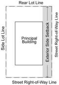
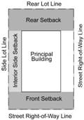
The minimum Setback standards of the Base District may be reduced by the City Commission, provided that:
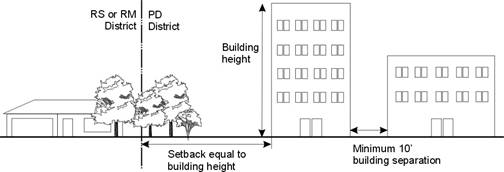
(i) Buildings located within the PD, and along any District boundary that is adjacent to RS and or RM Zoning Districts shall be Setback a distance at least equal to the Height of the proposed Building; and
(ii) All exterior walls of detached Buildings shall be separated by a minimum distance of 10 feet.
(iii) Balconies shall not be located along peripheral site Setbacks adjacent to RS zoned properties unless privacy Screening and Landscaping is included in the design.
(g) Height
The City Commission may increase maximum Height limits of the Base District if the Commission determines that such an increase is warranted to support the public benefit likely to result from the proposed development. Height increases shall be permitted only for Buildings set back from the boundary of the PD by the Height of the proposed Building plus 25 feet, so that the primary impact of the increased Height is on property within the PD.
(h) Balconies
Balconies above the second Story of a multi-Dwelling Unit Building are prohibited along the exterior of a Planned Development unless the Building Setback is increased to at least double the required minimum Setback and Landscaping is enhanced with two or more of the following features: a minimum 4’ Berm, a solid Screening fence (6’ minimum Height) or a masonry wall (6’ minimum Height). This provision shall apply only to those exterior sides of a Planned Development that are adjacent to RS zoning or to detached Dwelling Units.
(i) Parking and Loading
The City Commission may decrease the number of off-Street Parking and loading spaces required. Parking and loading areas shall comply with all otherwise applicable design standards.
(j) Buffer Areas
Development within 60 feet of the peripheral boundary of the PD shall be limited to the following:
(1) use category, Heights, Setbacks and minimum Lot sizes permitted in the Zoning District immediately adjoining the proposed PD on the date of preliminary development plan approval of the PD; and
(2) a landscaped buffer, including a Berm (minimum 4’ in Height), a masonry wall (minimum of 6’ in Height) or a fence (minimum 6’ in Height).
(k) Common Open Space
(1) Amount Required
The PD shall include at least the amount
of Common Open Space computed using one of the
following formulas, whichever produces the largest number:
(i)
(20%)
of the total area included in the PD; or
(ii) 300 square feet for each proposed Dwelling Unit in the PD.
20% of the total site area as Common Open Space. Environmentally sensitive lands, if present, shall be protected and included within the Common Open Space. 50% of the Common Open Space shall be developed as Recreational Open Space unless environmentally sensitive lands are present, in which case the amount of Recreational Open Space may be reduced to no less than 5% and no more than 10% of the Common Open Space, with the intent being to preserve all or as much environmentally sensitive lands as possible in their natural state.
(2)
Recreational Open Space
At least one-half of
the proposed Common Open Space shall be
suitable for use as and proposed for development as Recreational
Open Space.
(3)
Natural Open Space
To the maximum extent
practicable, the following types of lands shall be included in the Common Open Space as Natural
Open Space. To the extent that it is not practicable to include all of
such areas in the Common Open Space, the order
of types of lands included in this list shall be considered a priority list,
with the first item being the most important, the last being the least
important:
(i)
Floodway,
based on a 100-year storm;
(ii) Floodplain outside the
floodway, based on a 100-year storm;
(iii) Jurisdictional Wetlands;
(iv) Stream
Corridors;
(v) Stand of
Mature Trees
or individually significant mature trees;
(vi) Prominent
Geographic Features with Rocky Outcroppings; and
(vii) Archeological and
Historic Sites
(4) General Provisions
See Section 20-703 for General Provisions applicable to Open Space in a PD or Cluster Development.
(l) Additional Requirements and Standards
(1) Unified Control
No application for a PD will be accepted or approved unless all of the property included in the application is under unified Ownership or a single entity’s control.
(2) Street Access
PDs that will generate 100 or more average daily trips (based on traffic generation estimates of the Institute of Transportation Engineers’ Trip Generation Manual, 7th edition, or subsequent edition, or based on local estimates provided by the City) shall have Access to an Arterial Street using a Frontage or rear Access road or by taking direct Access to a Collector Street.
Individual residential Building Lot shall not take direct Access to an Arterial Street or a non-Residential Collector Street. Each individual residential Lot shall have Frontage on a public or Private Street that has been constructed to the Public Street standards of the City.
(3) Sidewalks
Sidewalks built to City specifications shall be built along both sides of all public and Private Streets. On Local Streets, sidewalks shall be at least 5 feet in width; on all other Streets sidewalks shall be at least 6 feet in width.
(4) Landscaping
The Landscaping and Screening standards of Article 10 apply to PDs. In addition, any part of the development area not used for Buildings, Structures, Parking, Streets, or Accessways shall be landscaped with a sufficient mixture of grass, vegetative Ground Cover, trees, and Shrubs, except those areas designated to be preserved with natural vegetation.
(5) Preservation of Natural Features
Mature stands of trees or individually significant mature trees, vegetative cover, watercourses and other natural site features shall be preserved to the greatest extent possible. At a minimum the common open space provisions in this section and the standards of Article 10 apply.
(6) Zoning Map
Approved PDs shall be identified on the Official Zoning District Map.
(7) Additional Conditions
The Planning Commission may recommend, and the City Commission may impose, other reasonable conditions and standards, as deemed necessary to ensure consistency with the purposes of this section and those of this Development Code. Such conditions may include limitations on the types of uses, Structures or Building Types to be allowed in the PD. When such conditions are imposed, an application will not be deemed approved until the applicant has complied with all of the conditions of approval.
(m) Additional Standards for PD’s with Residential and Nonresidential Uses
In PDs containing both residential and nonresidential uses, the nonresidential uses shall be designed, located, and oriented on the site so that such uses are directly accessible to residents of the PD. For the purposes of this Section, directly accessible shall mean pedestrian/Bicycle and automobile Access by way of improved sidewalks or paths and Streets that do not involve leaving the PD or using a major Thoroughfare. “Directly accessible” does not necessarily mean that nonresidential uses need to be located in a particular location but that the siting of such uses considers the accessibility of the residential component of the PD to the nonresidential use.
20-702 cluster housing projects
(a) Purpose
The cluster housing regulations of this section have several potential public benefits. They:
(1) provide flexible development options where the standard Lot and Block pattern is not practical because of physical constraints;
(2) promote the preservation of open space and natural areas;
(3) allow for grouping of development on a portion of the site while using the entire site area to calculate Density of the Base District.
(4) support reductions in development costs.
(b) General
(1) A Cluster Housing Project is a subdivision containing five (5) or more detached Dwellings each on its own Lot with some or all of the Lots reduced below required minimum Lot Area and width requirements, but where the overall project complies with the maximum Density standard of the Base District. Cluster Housing Projects require that planning for Lots and the locations of houses on the Lots be done at the same time. Because the allowable Building Envelope of each house is predetermined, greater flexibility in development standards is possible while assuring that the single-Dwelling character of the Zoning District is maintained.
(2) Under the cluster housing option, a subdivision can contain no more Lots than would otherwise be allowed for a conventional subdivision in the same Zoning District, but the individual Lots within the development can be smaller than required in a conventional subdivision. Smaller Lot sizes within a Cluster Housing Project are required to be offset by a corresponding increase in Common Open Space.
(c) Where Allowed; Procedure
Cluster Housing Projects are allowed by right in all residential Zoning Districts and in the CN1 District, as provided below.
(1) In RS Districts and the CN1 District, Cluster Housing Projects shall not include more than 35Dwelling Units. Larger projects in said Districts are subject to the Planned Development regulations of Section 20-701 and shall be reviewed and approved in accordance with the procedures of Section 20-1304.
(2) Cluster Housing Projects allowed by-right will be evaluated for compliance with applicable regulations and reviewed and approved in accordance with the subdivision procedures of Article 8 review process.
(d) Lot Area and Lot Width Requirements
There are no minimum Lot Area or Lot Width requirements for Cluster Housing Projects. Lots shall be adequate to meet all applicable standards of this Development Code.
(e) Housing Types
Detached Dwelling Units on individual Lots are the only type of housing allowed in a Cluster Housing Project. The proposed Building Envelope for all houses shall be shown on the subdivision plat with enough detail so that compliance with required Density and Dimensional Standards can be determined.
(f) Setbacks
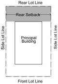
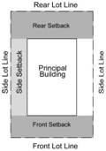
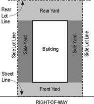
(1) A Setback equal to the minimum Front Setback of the Base District shall be provided along the entire perimeter of the Cluster Housing Project that is adjacent to any Street or right-of-way.
(2) A Setback equal to the minimum Rear Setback of the Base District shall be provided along the entire perimeter of the Cluster Housing Project that is not adjacent to any Street or right-of-way.
(3) Within the project, the distance between houses shall be at least 10 feet (to be measured in accordance with the Setback measurement provisions of Section 20-602(e)).
(g) Building Coverage
The Building coverage standards of the Base District do not apply to each individual Lot, but the total Building coverage of all Lots (in aggregate) may not exceed the maximum Building coverage standard of the Base District.
(h) Outdoor Area
The required minimum outdoor area standard per Dwelling Units of 240 Sq. Ft. shall be on each Lot.
(i) Common Open Space
(1) Amount Required
The Cluster Housing Project shall include at
least 10% of the total site area as
Common Open Space. the amount of Common
Open Space computed using whichever of the following formulas produces
the largest number:
(i)
The
total area resulting from the sum of the following: the difference between the
minimum Lot Area required for the Base District and the actual Lot
Area proposed for each Lot in the
Cluster Development; or
(ii) Ten percent (10%) of
the total site area included in the Cluster Housing Project.
Environmentally sensitive lands, if present, shall be protected and included within the Common Open Space. 30% of the Common Open Space shall be developed as Recreational Open Space, unless environmentally sensitive lands are present, in which case the amount of Recreational Open Space may be reduced to no less than 5% and no more than 10% of the Common Open Space, with the intent being to preserve all or as much environmentally sensitive lands as possible in their natural state.
(2)
Recreational Open Space
At least one-third of the proposed Common Open Space shall be suitable for use as and
proposed for development as Recreational Open Space.
(3)
Natural Open Space
To the maximum extent practicable, the
following types of lands shall be included in the Common
Open Space as Natural Open Space. To
the extent that it is not practicable to include all of such areas in the Common Open Space, the order of types of lands
included in this list shall be considered a priority list, with the first item
being the most important, the last being the least important and so on:
(i)
floodway,
based on a 100-year storm;
(ii)
Floodplain Outside The Floodway, based on a 100-year storm;
(iii)
jurisdictional
Wetlands;
(iv) Stream
Corridor;
(v) significant Stand of Mature Trees or individually significant
mature trees;
(vi) Prominent
Geographic Features with Rocky Outcroppings; and
(vii) archeological and
historic sites.
(4) General Provisions
See Section 20-703 for General Provisions applicable to Open Space in a Planned Development or Cluster Housing Project.
20-703 open space standards in cluster and Planned Developments
(a) Preservation Required
The Open Space land shall be preserved and maintained solely for the purposes specified in this Section and in such a manner as may be acceptable to the City Commission The method for accomplishing such preservation and maintenance of Open Space land shall be limited to one of the following:
(1) establishment of a mandatory-membership homeowner’s association to own and maintain the land in common for the Open Space purposes intended; or
(2) transfer of the land to a conservation trust or an institution, person, organization or other conservation-oriented entity together with the requisite requirements for maintenance of the land for the Open Space purposes intended; or
(3) dedication of the land to the City with executed deed restrictions that the City is party to, which ensure the land shall remain as dedicated open space, subject to City Commission acceptance of such dedication.
(b) Execution of Instruments
The City Commission shall require the Owner Developer
or Owner of the Open Space land to execute,
acknowledge and file at the Register of Deeds office such maps and documents
as, in the opinion of the Director of Legal Services, will effectively create a
trust, Easement or covenant running with the
land, for the benefit of the abutting Dwelling Unit Owner property owners in the development and of the City, which:
(1) will be binding on all future Owners of the Open Space land;
(2) will not be affected by any subsequent changes in zoning;
(3)
may
be enforced by adjoining property Owner property owners in the development or the City by
appropriate action in court for damage or equitable relief;
(4) will be perpetual;
(5) will assure appropriate maintenance of the Open Space land to the satisfaction of the City Commission;
(6) shall provide that if maintenance, preservation and/or use of the Open Space land no longer complies with the provisions of the trust, Easement or covenant, the City may take all necessary actions to effect compliance and assess the costs against the Owner in default;
(7)
shall
provide that such trust, Easement or covenant
may not be modified, altered, amended or changed without written approval of
the City Commission, and all beneficiary property Owners in the PD PUD or Cluster Housing Project development except in the case of
City-owned land in which case deed restrictions shall be binding.
Article 11. general development standards
|
20-1101 |
Protection Standards for Residential Districts |
|
20-1102 |
Intersection Visibility |
|
20-1103 |
Outdoor Lighting |
|
20-1104 |
Performance Agreements; Guarantees |
|
20-1105 |
Sidewalks |
|
20-1106 |
Agreement Not to Protest Formation of a Benefit District |
|
20-1107 |
Retail Market Impact Analysis |
|
20-1108 |
General Development Standards for Mixed Use(MU) Districts |
20-1101 Protection Standards for Residential Districts
(a) Design and Operational Compatibility Standards—Discretionary Approvals
As a condition of approval of any Special Use Permit, Map Amendment, site plan or other discretionary approval of any multi-Family use or nonresidential use located within 500 feet of any less intensive residential district, the City Commission, Planning Director, Planning Commission or other review body may impose conditions that exceed the minimum requirements of this Chapter and that, in the opinion of the review body, are necessary to reduce or minimize any potentially adverse impacts on residential property, including, but not necessarily limited to, the following:
(1) location on a site of activities that generate potential adverse impacts on adjacent uses, such as noises and glare;
(2) placement and buffering of trash receptacles;
(3) location of loading and delivery areas;
(4) lighting location, intensity, and hours of illumination;
(5) placement and illumination of outdoor vending machines, telephones, and similar outdoor services and activities;
(6) additional Landscaping and buffering;
(7) Height restrictions to preserve light and privacy and views of significant features as viewed from public property and rights-of-way;
(8) preservation of natural lighting and solar Access;
(9) ventilation and control of odors and fumes; and
(10) paving or other surface treatment for dust control.
(b) Height Limit on Projects Adjoining Certain Residential Zoning Districts
See Section 20-701(g) for Height limits in the PD district.
(c) Balconies of a multi-Dwelling Unit Building
Balconies above the second Story of a multi-Dwelling Unit Building are prohibited along the exterior of a RM development unless the Building Setback is increased to at least double the required minimum Setback and Landscaping is enhanced with two or more of the following features: a minimum 4’ Berm, a solid Screening fence (6’ minimum height) or a masonry wall (6’ minimum height). This provision shall apply only to those exterior sides of a Planned Development that are adjacent to RS zoning or to detached Dwelling Units.
(d) Implementation of
Sensitive Land
Standards
for Environmentally Sensitive Lands
(1)
Applicability
of Environmental Design Standards – Generally
The provisions of
this Article regarding environmental protection for sensitive lands shall apply
to all construction and development in all RS and RM Districts, with the exception of individually platted lots for
single or duplex dwellings which were platted prior to (the effective date of
this Text Amendment). except
as expressly exempted in this paragraph.
(2)
Applicability
of Environmental Design Standards – Effect on Development Type Environmentally
Sensitive Lands
(i)
Principal
Protected Areas.
If a significant
portion 500 sq ft or more of
a proposed development, as specified in this sub-section (d), consists
of lands falling in the following categories, any proposed development may
proceed only in accordance with the processes allowed by this sub-paragraph
section. The lands affected by this
section shall include the following lands, are listed below in a priority order for
protection:
a.
Regulatory Floodways, based on 100
year storm designated on the FEMA
Flood Insurance Rate Map for Douglas County and identified on the City GIS
Baseline Environmentally Sensitive Areas Map;
b.
Floodplain outside the Floodway, Regulatory Floodway Fringe, designated on the FEMA
Flood Insurance Rate Map for Douglas County based on 100 year
storm and identified on the City GIS
Baseline Environmentally Sensitive Areas Map;
c. Jurisdictional Wetlands, as determined by the Army Corps of Engineers;
d. Stream Corridors as defined in this Code and identified on the City GIS Baseline Environmentally Sensitive Areas Map;
e.
Stands of Mature Trees or Individually Significant Mature Trees;
as defined in this Code and identified on the
City GIS Baseline Environmentally Sensitive Areas Map; and
f.
Prominent Geographic Features with Rocky Outcroppings; and
f. Archaeological and Historic Sites listed on local, state, or federal registers.
(i) Determination of Development Land Area
In determining whether a portion of a proposed development consists of sensitive lands, all contiguous lands under the same Ownership or control shall be considered. Lands owned or controlled by a partnership, trust or corporation under the same effective control shall be considered, along with lands owned directly by the applicant and lands under option to the applicant or a partnership, trust or corporation under the effective control of the applicant.
(3) Procedures to be Followed
(i) Platted Lots—Amount Required
For all types of developments, required protection of environmentally sensitive lands shall be limited to a maximum protection area of 20% of the total land area. The protected environmentally sensitive lands shall be set aside as private Common Open Space or dedicated to the City as parkland or open space. Incentives for protection of environmentally sensitive lands in amounts above 20% of the total land area are included in Section 20-1101(f).
Development on a
platted Lot or Parcel
including more than 500 square feet of sensitive lands shall require submission
of a Sensitive Areas Site Plan [see Section 20-1101(e)], which shall be
consolidated with any other required site plan submitted. The development
shall be subject to any conditions related to the sensitive lands included in
approval of the subdivision or any Planned Development
application including the platted Lot(s).
(ii) Land not Previously
Subdivided
Development Process
Development on land not
previously subdivided and including which
contains more than 500 square feet of sensitive lands shall follow
the procedures required by this paragraph: require submission of a Sensitive Areas Site Plan [see Section
20-1101(f)], and may proceed through one of the following processes:
a. Site Planning. Development on properties containing more than 500 square feet of environmentally sensitive lands shall require submission of a Sensitive Areas Site Plan [see Section 20-1101(f)], which may be consolidated with any other required site plan submitted, but will be, in any event, required prior to approval of a development proposal. The plan shall clearly delineate the environmentally sensitive lands to be protected and shall include information regarding protection measures and maintenance.
b. Platting. Environmentally sensitive lands to be protected shall be located within tracts and/or easements. Information regarding ownership and maintenance responsibility of the tract or easement, as well as protection measures, shall be included on the preliminary and final plat.
c. Planned Development. Development standards in Section 20-701 apply. Environmentally sensitive lands to be protected shall be included within the Common Open Space.
d. Cluster Housing Project. Development standards in Section 20-702 apply. Environmentally sensitive lands to be protected shall be included within the Common Open Space.
1.
If
less than five percent (5%) of the land area consists of sensitive lands, the
property may be developed through a conventional subdivision, a cluster
subdivision or a Planned Development;
2.
If
five percent (5%) or more of the land area but less than 15% of the land area
consists of sensitive lands, the property may be developed through a cluster
subdivision or a Planned Development, but may
not be otherwise subdivided or developed;
3.
If
15% or more of the land area consists of sensitive lands, the property may be
developed only through a Planned Development.
(3)….Applicability of
Environmental Design Standards – Effect on Development Plan for Sensitive Lands
(i)
Dedication
Where the following types of lands are
included in a proposed development, such lands shall be included in any land
dedicated to the City as part of any required Open Space dedication, in the
priority order set forth in this paragraph, up to the required land dedication
for the development:
a.
Floodways, based on 100 year storm;
b.
Floodplain outside the Floodway,
based on 100 year storm;
c.
Jurisdictional
Wetlands;
d.
Stream Corridors;
e.
Stand of Mature Trees or individually significant mature trees;
f.
Prominent Geographic Features with Rocky Outcroppings; and
g.
Archaeological
and Historic Sites.
(ii) Private Open Space
Where the following types of lands are
included in a proposed development and will not be dedicated to the City, such
lands shall be included in required Open Space for the development, in the
priority order set forth in this paragraph, up to one-half the required Open
Space for the development, with the remaining one-half of the Open Space to be
suitable for active recreation:
a.
Floodways;
b.
Floodplains outside the Floodway,
based on 100 year storm;
c.
Jurisdictional
Wetlands;
d.
Stream Corridors;
e.
Stand of Mature Trees or Individually Significant Mature Trees;
f.
Prominent Geographic Features with Rocky Outcroppings; and
g.
Archaeological
and Historic Sites.
(iii) Other
Where the following types of lands are
included in a proposed development and will not be dedicated to the City or
included in private Open Space, the development plan shall be arranged so that
every proposed Lot has a Building Envelope meeting the other design standards
of this Code without encroaching on the designated sensitive lands:
a.
Floodways;
b.
Floodplain outside the Floodway,
based on 100 year storm;
c.
Jurisdictional
Wetlands;
d.
Stream Corridors;
e.
Stand of Mature Trees or Individually Significant Mature Trees;
f.
Prominent Geographic Features with Rocky Outcroppings; and
g.
Archaeological
and Historic Sites.
(4)
Applicability
of Environmental Design Standards – Effect on Development Intensity or
Density
Where the following
types of lands listed in Section
201101(d)(2)(i) are included in a proposed development, that
land, or a portion of that land, may be included in determining the
allowable Density or intensity of development and the allowable density, calculated on the total
land area, may be transferred to other developable portions of the property.
, in accordance with the following table. The percentage appearing
in a cell at the intersection of a type of sensitive land and its proposed
disposition shall be multiplied by the land area of that site to determine the
land area which may be considered in the computation of the allowed Density or intensity of development:
|
|
|
|
|
|
|
|
|
|
|
|
|
|
|
|
|
|
|
|
|
|
|
|
|
|
|
|
|
|
|
|
(e) Density Bonus Incentives for Protection of Additional Lands
Density bonuses are available to encourage the protection of environmentally sensitive lands in a greater amount than required.
(1). Applicability
A development shall qualify for a density bonus if environmentally sensitive lands noted in this Section are committed for preservation either through designation as a tract, through a conservation or landscape easement, or dedication to the City in addition to the area required in Section 20-1101(d)(3)(a) with the following exceptions or additions:
(i) The density bonus incentives do not apply to the protection of regulatory floodway above the amount required in this Section.
(ii) Slopes of 25% or greater may be included in the environmentally sensitive lands for the density bonus incentives, provided the required area being protected with features listed in Section 20-1101(d)(2)(i) equals or exceeds 20% of the total developable area.
(iii) Native prairie remnants may be included in the environmentally sensitive lands for the purpose of these incentives. The protection of any amount of native prairie remnant qualifies for the density bonus incentives, regardless of what amounts of other environmentally sensitive lands have been protected. If native prairie remnants are protected, the density bonus is calculated per Table 1 and 2 in Section 20-1101(e) as if the 20% of developable area has been protected.
(2) Approval Criteria
(i) In addition to these regulations, development on properties with certain environmentally sensitive lands, such as jurisdictional wetlands, may be restricted by state or federal regulations.
(ii) In order for a density bonus to be approved, City planning staff must determine that utilities and infrastructure are available to serve the additional density proposed and the design of the development does not negatively impact adjacent properties.
(iii) Land offered for dedication shall be subject to approval by the Governing Body.
(3) Density Bonus -- Increase in Number of Dwelling Units.
(i) Determination of Base Density.
The Base Density, the number of dwelling units which can be developed on a property, will be determined from a ‘concept plat’ or sketch plan provided by the applicant which shows the basic street layout and rights-of-way, the areas necessary for stormwater detention (based on an approved conceptual drainage study), the 20% of the site which is being protected with environmentally sensitive lands, and proposed lot layout in conformance with density and dimensional standards in Section 20-601.
(ii) Determination of Density Bonus.
If the density bonus meets the criteria noted in Section 20-1101(e)(1), the density bonus to be applied to the base density shall be calculated using the proportions in Table 1.
a. The density may exceed the Density Cap in multi-dwelling districts.
b. The density may equal but may not exceed the Density Cap for single-family and duplex districts.
c. Density Caps set by the Comprehensive Plan are noted in Table 2.
|
20-1101(e) TABLE 1 Density Bonus—Increase in number of dwelling units |
||||
|
% of property that is protected |
% increase in Dwelling Units |
|
% of property that is protected |
% increase in Dwelling Units |
|
21 |
1 |
31 |
11 |
|
|
22 |
2 |
32 |
12 |
|
|
23 |
3 |
33 |
13 |
|
|
24 |
4 |
34 |
14 |
|
|
25 |
5 |
35 |
15 |
|
|
26 |
6 |
36 |
16 |
|
|
27 |
7 |
37 |
17 |
|
|
28 |
8 |
38 |
18 |
|
|
29 |
9 |
39 |
19 |
|
|
30 |
10 |
40 |
20 |
|
|
20-1101(e) TABLE 2 Density Cap per Zoning District |
|||
|
Comprehensive Plan Designation |
Density Cap Horizon 2020 (du/acre) |
Zoning District |
Max. Density per Code (du/acre) |
|
Very-low density: single dwelling |
1 |
RS40 |
1.09 |
|
Low-density: single dwelling |
2-6 |
RS20 |
2.18 |
|
RS10 |
4.26 |
||
|
RS7 |
6.22 |
||
|
Medium density: single dwelling |
7-15 |
RS5 |
8.7 |
|
RS3 |
14.52 |
||
|
RSO |
14.52 |
||
|
Medium density: multi dwelling |
7-15
|
RM12, |
12 |
|
RM12D, |
12 |
||
|
RM15 |
15 |
||
|
High-density: multi-dwelling |
16-21 du / acre |
RM24, |
24 du / acre |
|
|
RM32 |
32 du / acre |
|
(iii) Standards Adjustment
a. In single-dwelling and duplex-dwelling zoning districts, it may be necessary to reduce the lot area and/or lot width requirements to permit the allowable density. These modifications may be made to the minimum degree necessary to accommodate the allowable density.
b. In multi-dwelling districts, it may be necessary to increase the height limitation, in addition to adjustments to the lot area and/or lot width requirements, to permit the allowable density. These modifications may be made to the minimum degree necessary to accommodate the allowable density.
(3). Density Bonus -- Increase in Developable Square Footage.
This bonus permits the construction of larger structures, and/or the addition of more impervious surface on a lot, rather than an increase in the number of dwelling units. The proportions listed in Table 3 apply to the increase in developable square footage. Each 1% of protected environmentally sensitive lands protected above that required by Code results in a 1% increase in the building or impervious surface coverage up to a maximum of 40%. (In no case shall the building coverage or impervious surface coverage exceed 90% of the lot).
|
20-1101(e)-TABLE 3 Density Bonus — Increase in Developable Area |
||||||
|
Zoning District |
Maximum Building Coverage (%) |
Maximum Impervious Coverage (%) |
Min Outdoor Area per Dwelling (sq ft) |
Int Side Setback (ft) |
Front Setback (ft) |
Rear setback (ft) Single frontage / double frontage |
|
RS40 |
15 |
25 |
-- |
20 |
25 |
30/35 |
|
RS20 |
30 |
50 |
-- |
20 |
25 |
30/35 |
|
RS10 |
40 |
70 |
-- |
10 |
25 |
30/25 |
|
RS7 |
45 |
70 |
-- |
5 |
25 |
30/25 |
|
RS5 |
50 |
75 |
240 |
5 |
20 |
20/25 |
|
RS3 |
50 |
75 |
150 |
5 |
15 |
20/25 |
|
RSO |
50 |
75 |
-- |
5 |
25 |
20/25 |
|
RM12D |
50 |
75 |
50 |
5 |
25 |
20/25 |
|
RM12 |
50 |
75 |
50 |
5 |
25 |
20/25 |
|
RMO |
50 |
75 |
50 |
5 |
25 |
20/25 |
|
RM15 |
50 |
75 |
50 |
5 |
25 |
25/25 |
|
RM24 |
50 |
75 |
50 |
5 |
25 |
20/25 |
|
RM32 |
60 |
80 |
50 |
5 |
25 |
20/25 |
|
* |
1% increase
|
1% increase
|
1% decrease
|
Adjusted as needed --not less than 5 |
Adjust as needed—not less than 15 |
Adjust as needed—not less than 15 |
*for each 1% protection above the required 20% (to maximum of 40% )
(iv) Standards Adjustment
In some cases the minimum outdoor area or setbacks may need to be reduced to accommodate the additional building or impervious surface coverage. This reduction may be made to the minimum degree necessary to accommodate the additional building or impervious surface coverage.
(e)(f) Sensitive Areas Site Plan Required
Prior to development on tracts or
portions of tracts of land where containing more than 500 square feet of environmentally
sensitive lands features
listed in Section 20-1101(d)(2)(i)specified
above exist, a sSensitive
aAreas sSite pPlan shall first be submitted to and
approved by the City in accordance with the requirements of Site Plan Review, Section
20-1305 including the public notice
procedures of Section 20-1305(g). This application process
may occur as part of a Planned Development
overlay zoning and/or subdivision review.
(1) Sensitive Areas Site Plan Contents
The Sensitive Areas Site Plan must be prepared in accordance with the requirements in Section 20-1305(f) with the exception that a Sensitive Areas Site Plan is not required to be completed by an engineer, architect or other qualified professional. In addition to the contents noted in Section 20-1305(f), the site plan shall:
(i) Clearly delineate the property boundaries.
(ii) Clearly delineate the boundaries of the environmentally sensitive lands listed in Section 20-1101(d)(2)(i).
(iii) Designate protected lands per the priority order in Section 20-1101(d)(2)(i).
(iv) Provide information on the ownership and maintenance responsibility for the protected lands.
(v) Provide information on the methods to be used to protect environmentally sensitive lands, both during construction and after.
(f)(g) Drainage Easements
All express drainage Easements dedicated, purchased or otherwise granted to the City in writing are governed by the standards of this section. No person may construct, maintain, or allow any natural or non-natural Structures or vegetative barriers (including but not limited to trees, Shrubbery, Berms, fences, and walls) upon drainage Easements that the Director of Public Works finds impedes, detains, retains, or otherwise interferes with the drainage of stormwater regardless of the source of stormwater.
(g)(h) Administration and Enforcement of Drainage Easements
The Director of Public Works may enter upon the drainage Easement, at any time and without notice, to inspect the drainage Easement.
(4) If the Director of Public Works finds that any natural or non-natural Structure or vegetative barrier impedes, detains, retains, or otherwise interferes with the drainage of stormwater, the Director of Public Works shall issue a notice to the Landowner to abate that condition within 30 days or such longer time period as the Director of Public Works deems appropriate. Within 14 days of the mailing of the notice to abate, the Landowner may request a hearing before the City Commission. If the Landowner requests a hearing, the City Commission shall determine the appropriateness of the order to abate, make findings as are appropriate, and order any necessary action as appropriate. The time period set by the Director of Public Works to abate the nuisance shall be stayed from the date the notice is filed until the City Commission has acted on the appeal. If the abatement is not completed within the time frame allowed by the notice to abate, including the period of time a stay is in effect, if any, or by the direction of the City Commission, the Director of Public Works will proceed with the abatement action. Pursuant to K.S.A. 12-6a17, the Director of Public Works shall order collection of the cost of this abatement upon the Landowner.
(5) This section does not create liability upon the City or its employees regarding the creation, dedication, inspection and maintenance of drainage Easements.
|
20-1701 |
General Terms |
|
20-1702 |
Use Categories in General |
|
20-1703 |
Adaptive Reuse of Designated Historic Property |
|
20-1704 |
Adaptive Reuse of Greek Housing |
|
20-1705 |
Agricultural Sales |
|
20-1706 |
Agricultural Services |
|
20-1707 |
Agriculture |
|
20-1708 |
Agriculture, Animal |
|
20-1709 |
Agriculture, Crop |
|
20-1710 |
Animal Services |
|
20-1711 |
Big Box |
|
20-1712 |
Building Maintenance Services |
|
20-1713 |
Business Equipment Sales and Services |
|
20-1714 |
Business Support Services |
|
20-1715 |
Commercial Node |
|
20-1716 |
Communication Service Establishments |
|
20-1717 |
Community Facilities |
|
20-1718 |
Construction Sales and Services |
|
20-1719 |
Cultural Exhibits and Libraries |
|
20-1720 |
Day Care |
|
20-1721 |
Detention |
|
20-1722 |
Dwelling, Attached |
|
20-1723 |
Dwelling, Detached |
|
20-1724 |
Eating and Drinking Establishments |
|
20-1725 |
Entertainment and Spectator Sports |
|
20-1726 |
Explosive Storage |
|
20-1727 |
Financial, Insurance and Real Estate (F.I.R.E.) Services |
|
20-1728 |
Food and Beverage Retail Sales |
|
20-1729 |
Funeral and Interment Services |
|
20-1730 |
Gasoline and Fuel Sales |
|
20-1731 |
Group Living |
|
20-1732 |
Health Care Office; Health Care Clinic |
|
20-1733 |
Hospital |
|
20-1734 |
Household Living |
|
20-1735 |
Industrial, General |
|
20-1736 |
Industrial, Intensive |
|
20-1737 |
Laundry Service |
|
20-1738 |
Lodge, Fraternal and Civic Assembly |
|
20-1739 |
Manufacturing and Production, Limited |
|
20-1740 |
Manufacturing and Production, Technological |
|
20-1741 |
Medical Facilities, (Health Center, Clinic, Hospital) |
|
20-1742 |
Mining |
|
20-1743 |
Mobile Home Park |
|
20-1744 |
Office, Administrative and Professional |
|
20-1745 |
Outpatient Care Facilities |
|
20-1746 |
Parking Facilities |
|
20-1747 |
Parking Lot |
|
20-1748 |
Personal Convenience Services |
|
20-1749 |
Personal Improvement Services |
|
20-1750 |
Postal & Parcel Services |
|
20-1751 |
Public Safety |
|
20-1752 |
Recycling Facilities |
|
20-1753 |
Religious Assembly |
|
20-1754 |
Repair Services, Consumer |
|
20-1755 |
Recreational Facilities |
|
20-1756 |
Research Services |
|
20-1757 |
Retail Sales and Service |
|
20-1758 |
Retail Sales, General |
|
20-1759 |
School |
|
20-1760 |
Scrap and Salvage Operations |
|
20-1761 |
Sexually Oriented Businesses |
|
20-1762 |
Sports and Recreation, Participant |
|
20-1763 |
Transient Habitation |
|
20-1764 |
Utilities and Services, Major |
|
20-1765 |
Utilities, Minor |
|
20-1766 |
Vehicle Sales and Service |
|
20-1767 |
Wholesale, Storage, and Distribution |
|
20-1768 20-1769 |
Telecommunications Facilities Institutional Use |
20-1701 General terms
|
Term |
Definition |
|
Access |
A way or means of approach to provide vehicular or pedestrian physical entrance to a property. |
|
Access, Cross |
A service drive providing vehicular Access between two or more contiguous sites so the driver need not enter the public Street system. |
|
Access Management |
The process of managing Access to land development while preserving the regional flow of traffic in terms of safety, capacity and speed. |
|
Accessory Dwelling Unit |
A Dwelling Unit that is incidental to and located on the same Lot as the Principal Building or use, when the Principal Building or use is a Dwelling. |
|
Accessory Structure |
A subordinate Structure, the use of which is clearly incidental to, or customarily found in connection with, and located on the same Lot as the Principal Building or use. |
|
Accessory Use |
A use that is clearly incidental to, customarily found in connection with, and (except in the case of off-Street Parking Space) located on the same Lot as the Principal Use to which it is related. |
|
Accessway , also Access Drive |
Any Driveway, Street, turnout or other means of providing for the movement of vehicles to or from the public roadway system. |
|
Adult Care Home |
See Group Home |
|
Agent (of Owner or Applicant) |
Any person who can show certified written proof that he or she is acting for the Landowner or applicant. |
|
Airport/Lawrence Municipal Airport |
The location from which take-offs and landings may be made by any manned aircraft, excluding free balloons, within the corporate limits of the City of Lawrence, Kansas. |
|
Airport Hazard |
Any Structure or tree or use of land that obstructs the airspace required for the flight of aircraft in landing or taking off at any Airport or is otherwise hazardous to such landing or taking off of aircraft. |
|
Alley |
A public or private way not more than 20 feet wide primarily designed to serve as a secondary means of Access to abutting property. |
|
Antenna |
Any system of wires, poles, rods, reflecting discs or similar devices used for the reception or transmission of electromagnetic waves which system is attached to an Antenna support Structure or attached to the exterior of any Building. The term includes devices having active elements extending in any direction, and directional beam-type arrays having elements carried by and disposed from a generally horizontal boom which may be mounted upon and rotated through a vertical mast, tower or other Antenna support Structure. |
|
Antenna, Receive-Only |
An Antenna capable of receiving but not transmitting electromagnetic waves, including Satellite Dishes. |
|
Antenna, Amateur Radio |
An Antenna owned and utilized by an FCC-licensed amateur radio operator or a citizens band radio Antenna. |
|
Arterial |
A Street classified as an Arterial in the Lawrence/Douglas County MPO Transportation Plan, as amended. |
|
Arterial Street, Minor |
A Street which is anticipated to have 2-4 travel lanes designed for speeds ranging from 30-45 mph and which is defined specifically as such on the Major Thoroughfares Map of the City. |
|
Arterial Street, Principal |
A Street which is anticipated to have 4-6 travel lanes designed for speeds ranging from 30-45 mph and which is defined specifically as such on the Major Thoroughfares Map of the City. |
|
Assisted Living |
Building or group of Buildings containing Dwellings designed for occupancy by persons 55 years or older where the Dwelling Units are independent but include special support services such as central dining and limited medical or nursing care. |
|
Basement |
Any floor level below the first Story in a Building, except that a floor level in a Building having only one floor level shall be classified as a Basement unless such floor level qualifies as a first Story as defined herein. |
|
Base Density |
The number of dwelling units that can be developed on a subject property, rather than the number of dwelling units that are permitted for the zoning district. Base density is the number of dwelling units that can be developed given the size of the parcel, the area required for street rights-of-way or infrastructure, the density and dimensional standards of Section 20-601(a), the environmental protection standards, as well as topographical or other features unique to the property. |
|
Base District |
Any Zoning District delineated on the Official Zoning District Map under the terms and provisions of this Development Code, as amended, for which regulations governing the area, use of Buildings, or use of land, and other regulations relating to the development or maintenance of existing uses or Structures, are uniform; but not including Overlay Zoning Districts. |
|
Base District, Special Purpose |
A District established to accommodate a narrow or special set of uses or for special purposes. The use of this term in the Development Code applies to Districts beyond the conventional residential, commercial, industrial and agricultural districts. Examples include government and public institutional uses, open space uses, hospital use, planned unit developments that pre-date the Effective Date of this Development Code or newly annexed urban reserve areas. |
|
Berm |
An earthen mound at least two feet (2’) above existing Grade designed to provide visual interest, Screen undesirable views and/or decrease noise. |
|
Bicycle |
A two-wheeled vehicle for human transportation, powered only by energy transferred from the operator's feet to the drive wheel. |
|
Bicycle- Parking Space |
An area whose minimum dimensions are two feet by six feet or two feet by four feet for upright storage. |
|
Big Box |
See Retail Establishment, Large. |
|
Block |
A Parcel of land entirely surrounded by public Streets, highways, railroad rights-of-way, public walks, parks or green strips, or drainage channels or a combination thereof. |
|
Block Face |
That portion of a Block or Tract of land facing the same side of a single Street and lying between the closest intersecting Streets. |
|
Boarding House |
A Dwelling or part thereof where meals and/or lodging are provided for compensation for one (1) or more persons, not transient guests, and where there are not more than 12 sleeping rooms, nor sleeping space for more than 24 people. |
|
Bufferyard |
A combination of physical space and vertical elements, such as plants, Berms, fences, or walls, the purpose of which is to separate and Screen changes in land uses from each other. |
|
Build-to-Line (minimum Building setback) |
An imaginary line on which the front of a Building or Structure must be located or built and which is measured as a distance from a public right-of-way. |
|
Building |
Any Structure having a roof supported by columns or walls, used or intended to be used for the shelter or enclosure of persons, animals, or property. When such a Structure is divided into separate parts by one or more walls unpierced by doors, windows, or similar openings and extending from the ground up, each part is deemed a separate Building, except as regards minimum Side Setback requirements as herein provided. |
|
Building Envelope |
The three-dimensional space on a Lot on which a Structure can be erected consistent with existing regulations, including those governing maximum Height and bulk and the Setback lines applicable to that Lot consistent with the underlying Zoning District, or as modified pursuant to a Variance, a site review, or prior City approval. |
|
Building Frontage |
That portion of a Building or Structure that is adjacent to or faces the Public Frontage. |
|
Building, Principal |
A Building in which is conducted the Principal Use of the Building site on which it is situated. In any residential District, any Dwelling shall be deemed to be the Principal Building on the site on which the same is located. |
|
Building Type (also referred to as housing type) |
A residential Structure defined by the number of Dwelling Units contained within. |
|
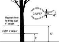
Caliper |
The American Association of Nurserymen standard for trunk measurement of nursery stock, as measured at six (6) inches above the ground for trees up to and including four-inch Caliper size, and as measured at 12 inches above the ground for larger sizes.
|
|
City Regulations |
Provisions of the Lawrence City Code or other provisions located in ordinances adopted by the City. |
|
Clear Zone |
An area designated within the Public Frontage of a Mixed Use Project which reserves space for a sidewalk. The Clear Zone shall be clear of any obstruction to a minimum height of eight (8) above grade. |
|
Cross Access Agreement |
A document signed and acknowledged by Owner of two or more adjoining pieces of property establishing Easements, licenses or other continuing rights for Access across one property to one or more other properties. |
|
Collector Street |
A Street which is anticipated to have two (2) travel lanes designed for speeds ranging from 25-35mph and which serves a collecting function by distributing traffic between local neighborhood Streets and Arterial Streets. |
|
Collector Street, Minor |
See Collector, Residential |
|
Collector Street, Residential |
Residential collector is a special category of collector street characterized by lower speeds & the residential nature of land uses along the corridor. Bicycle & pedestrian facilities are strongly recommended for residential collectors. Various traffic-calming treatments may be used to reduce travel speeds. Residential collector streets with adjacent residential land uses should be limited to two lanes. These streets can serve as a connector street between local streets and the thoroughfare system. |
|
Collector Street System |
A system of one (1) or more Collector Streets that allow traffic to be distributed to at least two (2) Arterial Streets. |
|
Common Open Space |
|
|
Comprehensive Plan also Comprehensive Land Use Plan |
The Lawrence/Douglas County Comprehensive Plan, also known as “Horizon 2020,” and any other applicable plans adopted by the Lawrence/Douglas County Metropolitan Planning Commission, as amended or superceded by adoption of a replacement plan from time to time. |
|
Conservation Easement |
A non-possessory interest of a holder in real property imposing limitations or affirmative obligations, the purposes of which include retaining or protecting natural, scenic or open-space values of real property, assuring its availability for agricultural, forest, recreational or open-space use, protecting natural resources, maintaining or enhancing air or water quality, or preserving the historical, architectural, archaeological or cultural aspects of real property. In case of any conflict between this definition and K.S.A. §58-3810, as it may be amended from time to time, the amended statute shall control and shall be used in the construction and interpretation of this Development Code. |
|
Deciduous |
A tree or Shrub with foliage that is shed annually. |
|
Deferred Item |
An item that has been deferred from a published agenda by the Planning Director, Planning Commission or the City Commission (City or County Commission), or by the applicant. |
|
Density |
A measure of the number ofDwelling Units contained within a given area of land, typically expressed as units per acre. |
|
Density Bonus: |
An incentive-based tool that permits property owners to increase the maximum allowable development on a property in exchange for helping the community achieve public policy goals, such as protection of environmentally sensitive areas. |
|
Density Cap: |
Maximum density levels set by the Comprehensive Plan. Low-density (6 dwelling units per acre); medium density (15 dwelling units per acre) and high density (24 dwelling units per acre). |
|
Density, Gross |
The numerical value obtained by dividing the total number ofDwelling Units in a development by the total area of land upon which theDwelling Units are proposed to be located, including rights-of-way of publicly dedicated Streets. |
|
Density, Net |
The numerical value obtained by dividing the total number ofDwelling Units in a development by the area of the actual Tract of land upon which theDwelling Units are proposed to be located, excluding rights-of-way of publicly dedicated Streets. |
|
Designated Transit Route |
Any bus route identified on the route map published by the Lawrence Transit System or KU on Wheels transit system. |
|
Development Activity |
Any human-made change to Premises, including but not limited to: (a) the erection, conversion, expansion, reconstruction, renovation, movement or Structural Alteration, or partial or total demolition of Buildings and Structures; (b) the subdivision of land; (c) changing the use of land, or Buildings or Structures on land; or (d) mining, dredging, filling, grading, paving, excavation, drilling, or Landscaping of land or bodies of water on land. |
|
Development Project, Major (Ord. 8465) |
Any development proposing the following:
a. Any Development Activity on a site that is vacant or otherwise undeveloped; or
b. Any Significant Development Project on a site that contains existing development, defined as:
1. Any modification to a site that alters Parking Areas, drive aisles, or impacts on-site pedestrian and vehicular circulation and traffic patterns that the Planning Director determines to be significant in terms of impacting adjacent roads or adjacent properties; or
2. In the IG zoning district, the construction of one or more Building(s) or building additions that contain a Gross Floor Area of fifty percent (50%) or more of the Gross Floor Area of existing Building(s); or
3. In any zoning district other than IG, the construction of one or more Building(s) or building additions that contain a Gross Floor Area of twenty percent (20%) or more of the Gross Floor Area of existing Building(s); or
4. Separate incremental Building additions below 50% for IG zoning and 20% for all other zoning districts of the Gross Floor Area of existing Building(s) if the aggregate effect of such Development Activity over a period of 24 consecutive months would trigger the 50% (for IG) or 20% (for all other zoning districts) threshold; or
5. The installation or addition of more than 50% for IG zoning and 20% for all other zoning districts of existing Impervious Surface coverage.
|
|
Development Project, Minor (Ord. 8465) |
Any development proposing the minor modification of a site, as determined by the Planning Director, which does not meet the criteria for a Standard or Major Development Project, or the proposed change in use to a less intensive use on a site which has an approved site plan on file with the Planning Office. Only sites which have an existing approved site plan on file which reflects existing site conditions are eligible for review as a Minor Development Project.
|
|
Development Project, Standard (Ord. 8465) |
a. For any property containing existing development which does not have an approved site plan on file with the Planning Office and which does not meet the criteria for a Major Development Project, any development proposing the following shall be considered a Standard Development Project:
1. a change in use to a less intensive use and where physical modifications to the site, excluding interior Building modifications, are proposed; or
2. A change in use to a more intensive use regardless of whether modifications to the site are proposed; or
3. the substantial modification of a site, defined as:
a. The construction of any new Building(s) on the site; or b. The construction of any Building addition that contains a Gross Floor Area of ten percent (10%) or more of the Gross Floor Area of existing Building(s); or c. Separate incremental Building additions below ten percent (10%) of the Gross Floor Area of existing buildings if the aggregate effect of such Development Activity over a period of 24 months would trigger the 10% threshold; or d. The addition of Impervious Surface coverage that exceeds 10% of what exists; or e. Any modification determined by the Planning Director to be substantial.
b. For property which does have an approved site plan on file with the Planning Office and which does not meet the criteria for a Major Development Project, any development proposing the following shall be considered a Standard Development Project:
1. any change in use of a site to a more intensive use regardless of whether modifications to the site are proposed; or
2. any modification of a site which meets the following criteria or proposes the following:
a. A modification to a site which alters the Parking Area, drive aisles, or on-site pedestrian and vehicular circulation and traffic patterns with impacts to the interior of the site; or b. A development, redevelopment, or modifications to the exterior style, design or material type of a Structure that is subject to the Commercial Design Standards; or c. An outdoor dining or hospitality use in the CD and CN1 Zoning Districts and any outdoor dining use located in any other Zoning District that would result in an increase of the number of Parking Spaces required; or d. In the IG zoning district, the construction of one or more new Building(s) or building additions that contain a Gross Floor Area of less than fifty percent (50%) of the Gross Floor Area of existing Building(s); or e. In any zoning district other than IG, the construction of one or more new Building(s) or building additions that contain a Gross Floor Area of less than twenty percent (20%) of the Gross Floor Area of existing Building(s); or f. In the IG zoning district, the installation or addition of less than fifty percent (50%) of existing Impervious Surface coverage; or g. In any zoning district other than IG, the installation or addition of less than twenty percent (20%) of existing Impervious Surface coverage; or h. Any modification to an approved site plan on file with the Planning Office which proposes an adjustment to the total land area of the site plan, if determined necessary by the Planning Director.
|
|
Development Zone, Primary |
Land area in a Mixed Use development designated at time of rezoning to the Mixed Use District and reserved for the most intense development proposed for the mixed use development. |
|
Development Zone, Secondary |
Land area in a Mixed Use development designated at time of rezoning to the Mixed Use District and reserved for less intense development than the Primary Development Zone, but more intense development than the Tertiary Development Zone. The Secondary Development Zone may serve as a transitional zone within a larger Mixed Use Development. |
|
Development Zone, Tertiary |
Land area in a Mixed Use development designated at time of rezoning to the Mixed Use District and reserved for the least intense development proposed for the mixed use development. |
|
Dependent Living Facility |
See Extended Care Facility |
|
Director, Planning |
See Planning Director |
|
Distance Between Structures |
The shortest horizontal distance measured between the vertical walls of two Structures as herein defined perpendicular to an axis, all points along which are midway between the vertical walls. |
|
District, Zoning |
A portion of the territory of the City of Lawrence within which certain uniform regulations and requirements or various combinations thereof apply under the provisions of this Chapter. |
|
Dormitory |
A Building occupied as the more-or-less temporary abiding place of individuals who are lodged with or without meals and in which there are more than eight (8) sleeping rooms or 16 sleeping accommodations. As such the rooms are let on a weekly or monthly basis or for greater period of time and are not available to the general public on a nightly basis as distinguished from a hotel. Ingress to and egress from all rooms is made through an inside lobby or office supervised by a person in charge at all hours. General kitchen and eating facilities may be provided for the primary use of the occupants of the Building, provided that the main entrance to these facilities is from within the Building. |
|
Drip Line |
An imaginary ground line around a tree that defines the limits of the tree canopy. |
|
Driveway |
A private drive or way providing Access for vehicles to a single Lot or facility. |
|
Driveway, Joint-Use |
A privately-owned Driveway that provides Access to 2 or more Lots in a commercial or industrial Development, such as in a shopping center (without Lots) or a business or industrial park. |
|
Driveway, Shared |
A single Driveway serving two or more adjoining Lots. |
|
Driveway Apron (or Approach) |
The Driveway area or approach located between the sidewalk and the curb. When there is no sidewalk, the apron or approach shall be defined as extending a minimum of six (6) feet from the back of the curb toward the Lot Line. |
|
Dwelling |
A Building or portion thereof designed or used exclusively as the residence or sleeping place of one or more persons, but not including a tent, trailer, or Mobile Home. |
|
Dwelling Unit |
One room, or a suite of two or more rooms, designed for or used by one Family or Housekeeping Unit for living and sleeping purposes and having only one kitchen or kitchenette. |
|
Easement |
A grant by a property Owner to the use of land by the public, a corporation, or persons for specific purposes such as the construction of utilities, drainageways, pedestrian Access, and roadways. |
|
Effective Date |
The date the ordinance adopting this Development Code takes effect. |
|
Elderhostel |
A Building occupied as the more-or-less temporary abiding place of individuals who are either: 1) participating in a travel-study program for senior citizens offered by a university or college; or 2) participating in a visiting faculty program at a university or college. These individuals are lodged with or without meals. These Buildings typically contain more than eight (8) sleeping rooms or 16 sleeping accommodations. The rooms are let on a weekly or monthly basis or for greater period of time, but are not available to the general public on a nightly basis, as distinguished from a hotel. Ingress to and egress from all rooms is made through an inside lobby or office supervised by a person in charge at all hours. General kitchen and eating facilities may be provided for the primary use of the occupants of the Building, provided that the main entrance to these facilities is from within the Building. |
|
Evergreen (Coniferous) Tree |
An Evergreen Tree, usually of pine, spruce or juniper genus, bearing cones and generally used for its Screening qualities. A Coniferous Tree may be considered a Shade Tree if it is at least five (5) feet in Height when planted and reaches a mature Height of at least 20 feet. |
|
Extended Care Facility (Dependent Living or Nursing Care Facility), General |
A long term facility or a distinct part of an institution occupied by nine (9) or more persons with a disability who require the provision of health care services under medical supervision for twenty-four (24) or more consecutive hours and who need not be related by blood or marriage. An Extended Care Facility must be licensed by one (1) or more of the following regulatory agencies of the State: Department of Social and Healing Arts, Behavioral Sciences Regulatory Board, State Board of Healing Arts, or Kansas Department on Aging. Disability means, with respect to a person: (a) a physical or mental impairment which substantially limits one (1) or more of such person’s major life activities; (b) a record of having such impairment; or (c) being regarded as having such impairment. Such term does not include current illegal use or addiction to a controlled substance, as defined in Sec. 102 of the Controlled Substance Act (21U.S.C.802). Extended Care Facilities include facilities for the provision of skilled nursing care, hospice care and similar services. |
|
Extended Care Facility (Dependent Living or Nursing Care Facility), Limited |
A long term facility or a distinct part of an institution occupied by not more than ten (10) persons, including eight (8) or fewer persons with a disability who need not be related by blood or marriage, and who require the provision of health care services under medical supervision for twenty-four (24) or more consecutive hours, and also not to be occupied by more than two (2) staff residents who need not be related by blood or marriage to each other or to other residents of the home. An Extended Care Facility must be licensed by one (1) or more of the following regulatory agencies of the State: Department of Social and Healing Arts, Behavioral Sciences Regulatory Board, State Board of Healing Arts, or Kansas Department on Aging. Disability means, with respect to a person: (a) a physical or mental impairment which substantially limits one (1) or more of such person’s major life activities; (b) a record of having such impairment; or (c) being regarded as having such impairment. Such term does not include current illegal use or addiction to a controlled substance, as defined in Sec. 102 of the Controlled Substance Act (21U.S.C.802). Extended Care Facilities include facilities for the provision of skilled nursing care, hospice care and similar services. |
|
Extended Stay Lodging |
A Building, including a single-Family residence, or group of Buildings providing living and sleeping accommodations for short-term occupancy, typically three (3) months or less. Bed & Breakfasts, hotels and motels are not considered extended stay facilities, although hotels and motels may provide this service. Extended stay facilities using single-Family Dwellings are not considered rental housing and are not subject to the rental licensing provisions of the City. |
|
Exterior Storage
|
Outdoor storage of any and all materials related to the principal use of the Lot or site, not including areas for special events, temporary outdoor events or seasonal events, transient merchant sales areas, or any other outdoor area dedicated to the sale of retail goods, regardless of the proprietor. Outdoor storage and sales areas, open to the public and in which transactions may occur are not considered Exterior Storage areas. |
|
Facade |
Exterior face (side) of a Building which is the architectural front, sometimes distinguished by elaboration or architectural or ornamental details. |
|
Family |
(1) A person living alone; (2) two or more persons related by blood, marriage, or legal adoption; (3) in an RS Zoning District, a group of not more than three persons not related by blood or marriage, living together as a single Housekeeping Unit in aDwelling Unit, as distinguished from a group occupying a Dormitory, Boarding House, lodging house, motel, hotel, fraternity house or sorority house; or (4) in a Zoning District other than RS, a group of not more than four persons not related by blood or marriage, living together as a single Housekeeping Unit in aDwelling Unit, as distinguished from a group occupying a Dormitory, Boarding House, lodging house, motel, hotel, fraternity house or sorority house. |
|
Floodplain |
The land inundated by a flood of a given magnitude as determined by the Flood Insurance Study or by an approved Hydrologic & Hydraulic Study. |
|
Floor Area |
The sum of the horizontal areas of each floor of a Building, measured from the interior faces of the exterior walls or from the centerline of walls separating two Buildings. |
|
Floor Area, Gross |
The sum of the horizontal areas of the several stories of a Building, measured from the exterior faces of exterior walls, or in the case of a common wall separating two Buildings, from the centerline of such common wall. |
|
Floor Area, Net |
The horizontal area of a floor or several floors of a Building or Structure; excluding those areas not directly devoted to the principal or Accessory Use of the Building or Structure, such as storage areas or stairwells, measured from the exterior faces of exterior or interior walls. |
|
Floor Area Ratio (F.A.R.) |
The sum of the horizontal areas of the several floors inside the exterior walls (excluding basements) of a Building or a portion thereof divided by the Lot Area. |
|
Foot-candle |
A unit of measurement referring to the illumination incident to a single point. One (1) Foot-Candle is equal to one (1) lumen uniformly distributed over an area of one (1) square foot. |
|
Frontage |
All the property on one side of a Thoroughfare between two intersecting Thoroughfares (crossing or terminating), or if the Thoroughfare is Dead-Ended, then all of the property abutting on one side between an intersecting Thoroughfare and the Dead-End. |
|
Frontage Road, Private |
Any thoroughfare that is not publicly owned and maintained and that is parallel and adjacent to any Lot Frontage as defined above. |
|
Grade |
The lowest point of elevation of the finished surface of the ground, paving or sidewalk within the area between the Building and the Lot Line or, when the Lot Line is more than 5 feet from the Building, between the Building and a line five feet from the Building. |
|
Greek Housing |
A group living Structure occupied by a university approved fraternity or sorority, certified by the Panhellenic Association or Intrafraternity Council at KU. Residential occupancy by the majority of residences primarily follows the academic calendar for fall and spring semesters each year. |
|
Ground Cover |
Living Landscape Materials or living low-growing plants other than turf grasses, installed in such a manner so as to provide a continuous cover of the ground surface and which, upon maturity, normally reach an average maximum Height of not greater than 24 inches. |
|
Ground Floor |
A level of Building floor which is located not more than 2 feet below nor 6 feet above finished Grade. |
|
Group Home (or Adult Care Home), General
|
Any Dwelling occupied by 11 or more persons, including eight (8) or more persons with a disability who need not be related by blood or marriage and staff residents who need not be related by blood or marriage to each other or to other residents of the home. The Dwelling is licensed by one (1) or more of the following regulatory agencies of the State: Dept. of Social and Healing Arts, Behavioral Sciences Regulatory Board, or State Board of Healing Arts. Disability means, with respect to a person: (a) a physical or mental impairment which substantially limits one (1) or more of such person’s major life activities; (b) a record of having such impairment; or (c) being regarded as having such impairment. Such term does not include current illegal use or addiction to a controlled substance, as defined in Sec. 102 of the Controlled Substance Act (21U.S.C.802). A Special Use Permit is required before operation of the home can begin. |
|
Group Home (or Adult Care Home), Limited
|
Any Dwelling occupied by not more than ten (10) persons, including eight (8) or fewer persons with a disability who need not be related by blood or marriage and not to exceed two (2) staff residents who need not be related by blood or marriage to each other or to other residents of the home. The Dwelling is licensed by one (1) or more of the following regulatory agencies of the State: Dept. of Social and Healing Arts, Behavioral Sciences Regulatory Board, or State Board of Healing Arts. Disability means, with respect to a person: (a) a physical or mental impairment which substantially limits one (1) or more of such person’s major life activities; (b) a record of having such impairment; or (c) being regarded as having such impairment. Such term does not include current illegal use or addiction to a controlled substance, as defined in Sec. 102 of the Controlled Substance Act (21U.S.C.802). |
|
Growing or Planting Season |
From the beginning of March to the end of June and from the beginning of September to the beginning of December. |
|
Height (Building) |
Refers to the vertical distance from the finished Grade, or base flood elevation where applicable, to the highest point of the coping of: a flat roof, the deck line of a mansard roof, or the average Height of the highest gable of a pitch or hip roof. |
|
Historic Resources Commission (HRC) |
The Commission established by Sections 22-201 – 22-205, part of the Conservation of Historic Resources of the Code of the City of Lawrence |
|
Home Occupation |
An Accessory Use that complies with the provisions of Section 20-537. |
|
Housekeeping Unit |
A suite of one or more rooms having separate cooking facilities, used as the domicile or home of one Family. |
|
Housing for the Elderly |
See Assisted Living or Extended Care Facility |
|
HRC |
See Historic Resources Commission |
|
Hydrologic and Hydraulic Study |
See Hydrologic and Hydraulic Study definition in Section 20-1205 |
|
Impervious Surface |
That portion of developed property which contains hard-surfaced areas (primed and sealed AB3, asphalt, concrete and Buildings) which either prevent or retard the entry of water into the soil material. |
|
Inactive File |
An application, either complete or incomplete, which has had no new information submitted within a period of twelve (12) or more months. New information within this context shall be information that responds to a request for additional information or that provides additional information essential to completing a review of the request in response to the land use review criteria, retail market information, or traffic impact analysis. |
|
Infrastructure |
Those man-made Structures which serve the common needs of the populations, such as: potable water systems, wastewater disposal systems, solid waste disposal sites or retention areas, storm drainage systems, electric, gas or other utilities, bridges, roadways, Bicycle paths or trails, pedestrian sidewalks, paths or trails and transit stops. |
|
Jurisdictional Wetland |
Wetlands which are regulated by Section 404 of the Clean Water Act and are under the regulatory jurisdiction of the Army Corps of Engineers (Corps) and the Environmental Protection Agency (EPA). |
|
Landowner |
See Owner |
|
Landscaped Peninsula |
A concrete curbed planting area typically found in Parking Lots to provide areas for trees and Shrubs between Parking Spaces and along the terminus of single and double Parking aisles. |
|
Landscape Material |
Such living material as trees, Shrubs, Ground Cover/vines, turf grasses, and non-living material such as: rocks, pebbles, sand, bark, brick pavers, earthen mounds (excluding pavement), and/or other items of a decorative or embellishing nature such as: fountains, pools, walls, fencing, sculpture, etc. |
|
Landscaping |
Any combination of living plants such as trees, Shrubs, plants, vegetative Ground Cover or turf grasses. May include structural features such as walkways, fences, benches, works of art, reflective pools, fountains or the like. Landscaping shall also include irrigation systems, Mulches, topsoil use, soil preparation, re-vegetation or the preservation, protection and replacement of trees. |
|
Licensed Premises |
A Premises where alcoholic liquor or cereal malt beverages, or both, by the individual drink as defined by K.S.A. Chapter 41, and amendments thereto, is served or provided for consumption or use on the Premises with or without charge. This term shall include drinking establishments, Class A Private Clubs, Class B Private Clubs, and cereal malt beverage retailers, all as defined by K.S.A. Chapter 41, and amendments thereto and City Regulations. |
|
Light Court |
An area within the Public Frontage in a Mixed Use development adjacent to the Building Frontage which provides a means of outdoor light to reach an underground level of a Structure. It may also provide a means of emergency exit from the Structure but shall not serve as a primary entrance or exit to the Structure. |
|
Light Truck |
A truck or other motor vehicle, one ton or less in rated capacity, with a single rear axle and single pair of rear wheels. |
|
Livestock |
Any animal customarily kept for producing food or fiber. |
|
Local Street |
A Street which is anticipated to have two (2) travel lanes at desirable speeds of up to 30mph and which provides Access to abutting property and primarily serves local traffic. |
|
Local Street System |
A system of two (2) or more Local Streets that allow traffic to be distributed throughout a neighborhood. |
|
Lot |
A contiguous Parcel or Tract of land located within a single Block fronting on a dedicated public Street that is occupied or utilized, or designated to be occupied, developed, or utilized, as a unit under single Ownership or control. A Lot may or may not coincide with a Lot shown on the official tax maps or on any recorded subdivision or deed. |
|
Lot Area |
The total horizontal area within the Lot Lines of a Lot. |
|
Lot Frontage |
See Frontage |
|
Lot, Corner |
A Lot abutting upon two or more Streets at their intersection, or upon two parts of the same Street, such Streets or part of the same Street forming an angle of more than 45° and of less than 135°. The point of intersection of the Street Lines is the corner. Any portion of a Corner Lot that is more than 100 feet from the point of intersection of the two Street Lines or the two tangents of the same Street shall not be considered a Corner Lot.
|
|
Lot, Through |
A Lot abutting two Streets, not at their intersection. Any Lot meeting the definition of Corner Lot shall not be considered a Through Lot; any Lot abutting two Streets and not meeting the definition of a Corner Lot shall be considered a Through Lot.
|
|
Lot Depth |
The mean horizontal distance between the Front Lot Line and Rear Lot Line of a Lot. |
|
Lot Line |
A boundary of a Lot. |
|
Lot Line, Exterior Side |
A Side Lot Line separating a Lot from a Street other than an Alley. |
|
Lot Line, Front |
The Street Line at the front of a Lot. On Corner Lots, the Landowner may choose either Street Frontage as the Front Lot Line. |
|
Lot Line, Rear |
The Lot Line opposite and most distant from, and parallel or closest to being parallel to, the Front Lot Line. A triangular Lot has no Rear Lot Line. |
|
Lot Line, Side |
A Lot Line that is not a Front Lot Line or Rear Lot Line. |
|
Lot Width |
Lot Width is the distance between Side Lot Lines measured at the point of the required Front Setback or chord thereof. |
|
Manufactured Home |
Any Structure that is manufactured to the standards embodied in the National Manufactured Home Construction and Safety Standards (generally know as the HUD Code) established in 1976 pursuant to 42 U.S.C. Sec. 5403, but does not comply with the standards and provisions of Section 20-513. |
|
Manufactured Home, Residential-Design |
Any Structure that is manufactured to the standards embodied in the National Manufactured Home Construction and Safety Standards (generally know as the HUD Code) established in 1976 pursuant to 42 U.S.C. Sec. 5403 and that also complies with the standards and provisions of Section 20-513. (Ord. 8098) |
|
Massing |
The size and shape of Structure(s) individually and their arrangements relative to other Structure(s). |
|
Mature Trees, Stand of |
An
area of ½ acre (21,780 sq ft) or more located on the ‘development land area’, per Section 20-1101(d)(2)(ii) or on other contiguous residentially zoned properties |
|
Minimum Elevation of Building Opening |
The minimum elevation above sea level at which a Building located in the Floodplain may have a door, window, or other opening. |
|
Mixed Use |
The development of a Lot, Tract or Parcel of land, Building or Structure with two (2) or more different uses including, but not limited to: residential, office, retail, public uses, personal service or entertainment uses, designed, planned and constructed as a unit. |
|
Mixed Use Structure, Horizontal |
A Building or Structure containing both nonresidential and residential uses distributed horizontally throughout the Structure. |
|
Mixed Use Structure, Vertical |
A Building or Structure, a minimum of two stories in height, containing both nonresidential and residential uses distributed vertically throughout the Structure. |
|
Mobile Home |
Any vehicle or similar portable Structure having no foundation other than wheels or jacks or skirtings and so designed or constructed as to permit occupancy for Dwelling or sleeping purposes. Mobile Home includes any Structure that otherwise meets this description, but that was not subject to the National Manufactured Home Construction and Safety Standards (generally known as the HUD Code), established in 1976 pursuant to 42 U.S.C. Sec. 5403, at the time it was manufactured. Mobile Homes are considered to be Dwelling Units only when they are parked in a Mobile Home Park. |
|
Moderately-Priced Dwelling Unit |
A Dwelling Unit marketed and reserved for occupancy by a household whose income is equal to or less than 80% of the City of Lawrence’s median household income, as defined by the most current U.S. Department of Housing and Urban Development (HUD) guidelines. |
|
Mulch |
Non-living organic material customarily used to retard soil erosion and retain moisture. |
|
Native Prairie Remnants: |
Prairie areas that have remained relatively untouched on undeveloped, untilled portions of properties are ‘native prairies’. Native prairie remnants will be confirmed by the Kansas Biological Survey, or a consulting firm with local expertise in these habitats, as areas that have remained primarily a mixture of native grasses interspersed with native flowering plants. (These areas have not been planted, but are original prairies). A list of approved consulting firms for prairie determination is available in the Planning Office.
|
|
Natural Drainageway |
Natural rivers, streams, channels, creeks or other areas that naturally convey Stormwater runoff or portions thereof that have not been channelized and which is unaltered and retains a predominantly natural character. |
|
Natural Open Space |
Common Open Space that includes undisturbed natural resources, such as Floodplains, Wetlands, steep slopes, and Woodlands. |
|
Nodal Development Plan |
A land use plan for all four corners of an intersection that applies to the redevelopment of existing commercial center areas or new commercial development for neighborhood, community or regional commercial centers, as described in Horizon 2020, and is designed to avoid continuous lineal and shallow Lot Depth developments along Street corridors through the use of natural and man-made physical characteristics to create logical terminus points for the Node. |
|
Node |
An identifiable grouping of uses subsidiary and dependent upon a larger urban grouping of similar related uses. |
|
Non-encroachable Area |
That portion of a Lot or development set aside for enjoyment of the natural features or sensitive areas contained within it that cannot be encroached upon by Building or Development Activity, excluding encroachment for common maintenance needs of the land, its vegetation, natural stream beds, etc. |
|
Nursing Care Facility |
See Extended Care Facility |
|
Official Zoning District Map |
A map or maps outlining the various Zoning District boundaries of the City of Lawrence, Kansas. |
|
Open Porch |
A roofed space attached to a Building on one side and open on the three remaining sides. |
|
Open Use of Land |
A use that does not involve improvements other than grading, drainage, fencing, surfacing, signs, utilities, or Accessory Structures. Open uses of land include, but are not limited to, auction yards, auto wrecking yards, junk and salvage yards, dumps, sale yards, storage yards and race tracks. |
|
Ornamental Tree |
A Deciduous tree possessing qualities such as flowers, fruit, attractive foliage, bark or shape, with a mature Height generally under 40 feet. |
|
Outdoor Use Zone |
An area designated for outdoor use by a nonresidential or residential tenant within the Public Frontage in a Mixed Use development. At ground level, Outdoor Use Zones may include sidewalk dining, sidewalk sales, product demonstrations or any use accessory and incidental to a permitted nonresidential use in the Mixed Use District. Outdoor Use Zones may also include upper level uses such as balconies or terraces as well as Building-mounted signs. |
|
Overlay Zoning District (or Overlay Zoning District) |
Any Zoning District included in this Development Code with the word “overlay” in its title. The Overlay Zoning District regulations are found in Article 3 of this Development Code. |
|
Owner |
An individual, association, partnership or corporation having legal or equitable title to land other than legal title held only for the purpose of security. For the purpose of notice, the Owner may be determined using the latest Douglas County Appraiser’s assessment roll. |
|
Parcel |
A Lot or contiguous tracts owned and recorded as the property of the same persons or controlled by a single entity. |
|
Parking Access |
Any public or private area, under or outside a Building or Structure, designed and used for parking motor vehicles including parking Lots, garages, private Driveways and legally designated areas of public Streets. |
|
Parking Area |
An area devoted to off-Street Parking of vehicles on any one Lot for public or private use. |
|
Parking Space |
A space for the parking of a motor vehicle or Bicycle within a public or private Parking Area. Typically Parking Spaces for private uses are located off the public right-of-way. |
|
Peak Hour |
The four (4) highest contiguous 15-minute traffic volume periods. |
|
Pedestrian Scale (human scale) |
Means the proportional relationship between the dimensions of a Building or Building element, Street, outdoor space or Streetscape element and the average dimensions of the human body, taking into account the perceptions and walking speed of a typical pedestrian. |
|
Planned Development |
Developments processed and considered in accordance with the procedures specified in the Planned Development Overlay Zoning District provisions of Sec. 20-701 and in the Cluster Housing Projects provisions of Sec. 20-702. Generally, an area of land controlled by the Landowner to be developed as a single entity, commonly pursuant to an Overlay Zoning District, for a number of Dwelling Units, office uses, commercial uses, or combination thereof, if any, wherein a development plan detailing the proposed development and adjacent areas directly impacted thereby is reviewed and approved by the appropriate decision maker. In approving the development plan, the decision maker may simultaneously modify specified standards of the Base District. |
|
Planning Commission |
The Lawrence-Douglas County Metropolitan Planning Commission established by City Ordinance 3951/ County Resolution 69-8 on March 24th, 1969. |
|
Planning Director |
The Director of the Lawrence-Douglas County Metropolitan Planning Commission or her or his designee. |
|
Premises |
A Lot, together with all Buildings and Structures thereon. |
|
Principal Building |
See Building, Principal |
|
Principal Use |
The primary purpose for which land or a Structure is utilized, based in part on the amount of Floor Area devoted to each identifiable use. The main use of the land or Structures as distinguished from a secondary or Accessory Use. |
|
|
|
|
Public Frontage |
The publicly-owned layer between the Lot line or Street Line and the edge of the vehicular lanes. The public frontage may include sidewalks, street planters, trees and other vegetated landscaping, benches, lamp posts, and other street furniture. |
|
Public Frontage, Primary |
The Public Frontage along a designated Primary Development Zone. Primary Public Frontages are commonly associated with pedestrian-oriented urban commercial and retail areas in Mixed Use settings. They are commonly served by or are accessible to public transit and may contain medium to high residential densities and Vertical Mixed Use Structures. Primary Public Frontages are designed to accommodate heavy pedestrian traffic, street vendors and sidewalk dining and typically consist of a sidewalk or clear area paved from the back of curb of the Thoroughfare to the Building Frontage or Right-of-way line, reserving space for street furniture. |
|
Public Frontage, Secondary |
The Public Frontage along a designated Secondary Development Zone. Secondary Public Frontages are commonly associated with pedestrian-oriented Thoroughfares and Mixed Use settings. They are designed to accommodate moderate amounts of pedestrian traffic and typically consist of a sidewalk or clear area adjacent to the Building Frontage or Right-of-way line, reserving space for street furniture, and a landscaped strip with street trees between the back of curb of the Thoroughfare and the sidewalk or clear area. |
|
Public Frontage, Tertiary |
The Public Frontage along a designated Tertiary Development Zone. Tertiary Public Frontages are commonly associated with pedestrian-friendly Thoroughfares in lower intensity mixed residential settings, consisting of a 5’ wide sidewalk and street trees. Tertiary Public Frontages are designed to accommodate pedestrians who seek to walk to a nearby destination. |
|
Recreational Open Space |
Common Open Space that is improved and set aside, dedicated, or reserved for recreational facilities such as swimming pools, play equipment for children, ball fields, ball courts, and picnic tables. |
|
Recyclable Materials |
Reusable materials including but not limited to metals, glass, plastic, paper and yard waste, which are intended for remanufacture or reconstitution for the purpose of using the altered form. Recyclable Materials do not include refuse or hazardous materials. Recyclable Materials may include used motor oil collected and transported in accordance with environmental and sanitation codes. |
|
Registered Neighborhood Association |
A neighborhood or local interest group that represents a defined area of the City and that has registered with the Planning Director in accordance with the applicable registration procedures of the Planning Director. |
|
Regulatory Flood |
See Base Flood definition in Article 12. |
|
Regulatory Floodplain |
See Floodplain definition in Article 12. |
|
Regulatory Floodway |
See Floodway definition in Article 12. |
|
Regulatory Floodway Fringe |
See Floodway Fringe definition in Article 12. |
|
Residential Collector |
See Collector, Residential |
|
Residential-Design Manufactured Home |
See Manufactured Home, Residential-Design |
|
Retail Establishment, Large |
An establishment engaged in retail sales, where the aggregate of retail uses within a Building is 100,000 or more gross square feet of Floor Area that may or may not include ancillary uses with internal Access from the Principal Use Building. |
|
Retail Establishment, Medium |
An establishment engaged in retail sales, provided the aggregate of retail uses within a Building is less than 100,000 gross square feet of Floor Area. |
|
Retail Establishment, Specialty |
An establishment engaged in retail sales where new or used goods or secondhand personal property is offered for sale to the general public by a multitude of individual vendors, usually from compartmentalized spaces within a Building. A specialty retail sales establishment shall not exceed 100,000 gross square feet of Floor Area and may have an unlimited number of individual vendors within it. |
|
Root System Zone |
A subsurface area designated within the Public Frontage in a Mixed Use development. Such zones shall reserve space for the root system of street trees and landscaping planted in the Street Tree & Furniture Zone. |
|
Sadomasochistic Practices |
Flagellation or torture by or upon a person clothed or naked, or the condition of being fettered, bound, or otherwise physically restrained on the part of one so clothed or naked. |
|
Satellite Dish |
A dish Antenna, with ancillary communications equipment, whose purpose is to receive communication or other signals from orbiting satellites and other extraterrestrial sources and carry them into the interior of a Building. |
|
Scale |
A quantitative measure of the relative Height and Massing of Structure(s) Building(s) and spaces. |
|
Screen or Screening |
A method of visually shielding, obscuring, or providing spatial separation of an abutting or nearby use or Structure from another by fencing, walls, Berms, or densely planted vegetation, or other means approved by the Planning Director. |
|
Setback |
The minimum horizontal distance by which any Building or Structure must be separated from a street right-of-way or Lot line. (See also 20-602(e)) |
|
Setback, Front |
The Setback required between a Building and the Front Lot Line.
|
|
Setback, Rear |
The Setback required between a Building and the Rear Lot Line.
|
|
Setback, Side |
The Setback required between a Building and the Side Lot Line.
|
|
Setback, Side (Exterior) |
The Setback required between a Building and the Exterior Side Lot Line.
|
|
Setback, Side (Interior) |
The Setback required between a Building and the Interior Side Lot Line.
|
|
Sexually Oriented Media |
Magazines, books, videotapes, movies, slides, CD-ROMs or other devices used to record computer images, or other media that are distinguished or characterized by their emphasis on matter depicting, describing or relating to Specified Sexual Activities or Specified Anatomical Areas. |
|
Sexually Oriented Novelties |
Instruments, devices or paraphernalia either designed as representations of human genital organs or female breasts, or designed or marketed primarily for use to stimulate human genital organs. |
|
Shade Tree |
Usually a Deciduous tree, rarely an Evergreen; planted primarily for its high crown of foliage or overhead Canopy. |
|
Shared Parking |
Development and use of Parking Areas on two (2) or more separate properties for joint use by the businesses or Owner of these properties. |
|
Shrub |
A Deciduous, Broadleaf, or Evergreen plant, smaller than an Ornamental Tree and larger than Ground Cover, consisting of multiple stems from the ground or small branches near the ground, which attains a Height of 24 inches. |
|
Significant Development Project |
1. Any modification to a site that alters Parking Areas, drive aisles, or impacts on-site pedestrian and vehicular circulation and traffic patterns that the Planning Director determines to be significant in terms of impacting adjacent roads or adjacent properties; or
2. In the IG zoning district, the construction of one or more Building(s) or building additions that contain a Gross Floor Area of fifty percent (50%) or more of the Gross Floor Area of existing Building(s); or
3. In any zoning district other than IG, the construction of one or more Building(s) or building additions that contain a Gross Floor Area of twenty percent (20%) or more of the Gross Floor Area of existing Building(s); or
4. Separate incremental Building additions below 50% for IG zoning and 20% for all other zoning districts of the Gross Floor Area of existing Buildings if the aggregate effect of such Development Activity over a period of 24 consecutive months would trigger the 50% (for IG) or 20% (for all other zoning districts) threshold; or
5. The installation or addition of more than 50% for IG zoning and 20% for all other zoning districts of existing Impervious Surface coverage.
|
|
Slip Road |
A road which provides access to and runs a course parallel to an Arterial Street or other limited access street or highway. Slip Roads are commonly used along boulevards to provide access to adjacent properties, on-street parking, and to buffer high-speed traffic lanes from pedestrian areas. Slip roads may also be known as access roads. |
|
Special Purpose Base District |
See Base District, Special Purpose |
|
Specified Anatomical Areas |
(1) Less than completely and opaquely covered: human genitals, pubic region, buttock and female breast below a point immediately above the top of the areola; and (2) human male genitals in a discernibly turgid State, even if completely and opaquely covered. |
|
Specified Sexual Activities |
Human genitals in a State of sexual stimulation or arousal or acts of human masturbation, sexual intercourse or sodomy or fondling or other erotic touching of human genitals, pubic region, buttock or female breast. |
|
Story |
That portion of a Building included between the upper surface of any floor and the upper surface of the floor next above, except that the topmost Story shall be that portion of a Building included between the upper surface of the topmost floor and the ceiling or roof above. If the finished floor level directly above a Basement or unused under-floor space is more than six (6) feet above Grade as defined herein for more than 50% of the total perimeter or is more than 12 feet above Grade as defined herein at any such point, or unused under-floor space shall be considered a Story. |
|
Stream Corridor |
A
strip of land 100 feet wide, of which the centerline shall be the centerline
of a stream that is not |
|
Street, Arterial |
Arterial Streets are the highest level of Street classification, generally providing for longer distance trips with relatively high traffic volumes and high speeds for the context. Principal Arterials permit traffic flow through the urban area and between major destinations. Minor Arterials collect and distribute traffic from principal Arterials and expressway to Streets of lower classification, and, in some cases, allow traffic to directly Access destinations. |
|
Street, Collector |
A Collector Street provides for land Access and traffic circulation within and between residential neighborhoods and commercial and industrial areas. They distribute traffic movements from these areas to the Arterial Streets. Collectors do not typically accommodate long through trips and are not continuous for long distances. |
|
Street, Cul-de-sac |
A Street having only one outlet and being permanently terminated by a vehicle Turnaround at the other end. |
|
Street, Dead-End |
A Street having only one outlet and which does not benefit from a Turnaround at its end. |
|
Street, Expressway |
Any divided Street or highway with no Access from Abutting property and which has either separated or at-Grade Access from other public Streets and highways. |
|
Street, Freeway |
Any divided Street or highway with complete Access Control and Grade separated interchanges with all other public Streets and highways. |
|
Street, Limited Local |
A Local Street providing Access to not more than eight Abutting single-Family residential Lots. |
|
Street, Local |
Local Streets provide direct Access to adjacent land uses. Direct Access from a Local Street to an Arterial Street should be discouraged. |
|
Street, Marginal Access |
A Street that is generally parallel and adjacent to an Arterial Street or other limited-Access Street and that is designated to provide direct Access to adjacent property. Marginal Access Streets are commonly known as “Frontage Roads.” |
|
Street, Private |
Any tract of land or access easement set aside to provide vehicular Access within a Planned Development that is not dedicated or intended to be dedicated to the City and is not maintained by the City. Owners of a private street may choose to gate access to this type of street from the general public. |
|
Street, Public |
A way for vehicular traffic, whether designated as a local, collector, arterial, freeway or other designation, which is improved to City standards, dedicated for general public use, and maintained by the City. The term shall also include alleys. |
|
Street, Ultimate Design |
The Street design that is based on the planned carrying capacity of the roadway consistent with its functional classification on the Major Thoroughfares Maps in the Comprehensive Plan. |
|
Street Line |
The line separating the Street right-of-way from the abutting property. |
|
Street Tree and Furniture Zone |
An area designated within the Public Frontage in a Mixed Use development. Such zones shall reserve space for street trees and other landscaping as well as street furniture including, but not limited to benches, street lights and transit stops. |
|
Streetscape |
The built and planned elements of a street that define the street’s character. |
|
Structural Alteration |
Any change in the supporting or structural members of a Building, including but not limited to bearing walls, columns, beams or girders, or any substantial change in the roof, exterior walls, or Building openings. |
|
Structure |
A Building or anything constructed that requires permanent location on the ground or attachment to something having a permanent location on the ground, including but not limited to fences, signs, billboards, and Mobile Homes. |
|
Subsurface Utility Zone |
A subsurface area designated within the Public Frontage in a Mixed Use development. Such zones shall reserve space for public utilities. |
|
Thoroughfare |
Any public right-of-way that provides a public means of Access to abutting property. |
|
Tract (of land) |
An area, Parcel, site, piece of land or property that is the subject of a development application or restriction. |
|
Transitional Use |
A permitted use or Structure that, by nature or level and scale of activity, acts as a transition or buffer between two (2) or more incompatible uses. |
|
Tree Protection |
Means the measures taken, such as temporary fencing and the use of tree wells, to protect existing trees from damage or loss during and after construction projects. |
|
Trip Generation |
The total number of vehicle trip ends produced by a specific land use or activity. |
|
Unnecessary Hardship |
The condition resulting from application of these regulations when viewing the property in its environment that is so unreasonable as to become an arbitrary and capricious interference with the basic right of private property ownership, or convincing proof exists that it is impossible to use the property for a conforming use, or sufficient factors exist to constitute a hardship that would in effect deprive the Owner of their property without compensation. Mere financial loss or the loss of a potential financial advantage does not constitute Unnecessary Hardship. |
|
Vertical Mixed Use Structure |
See Mixed Use Structure, Vertical |
|
|
|
|
Woodlands |
Natural hardwood forests, whether or not actively forested. |
|
Working Days |
Monday through Friday, 8AM to 5PM excluding city holidays |
|
Yard |
Any Open Space located on the same Lot with a Building, unoccupied and unobstructed from the ground up, except for accessory Buildings, or such projections as are expressly permitted by these regulations. “Yard” refers to the actual open area that exists between a Building and a Lot Line, as opposed to the Required Yard or open area (referred to as a “Setback”)
|
|
Yard, Front |
A space extending the full width of a Lot between any Building and the Front Lot Line and measured perpendicular to the Building at the closest point to the Front Lot Line. |
|
Yard, Rear |
A space extending the full width of a Lot between the Principal Building and the Rear Lot Line and measured perpendicular to the Building at the closest point to the Rear Lot Line. |
|
Yard, Required |
The unobstructed Open Space measured from a point on a Principal Building to the Lot Line from the ground upward, within which no Structure shall be located, except as permitted by this Development Code. It is the three-dimensional equivalent of the required Setbacks for every Lot. |
|
Yard, Side |
A space lying between the side line of the Lot and the nearest line of the Principal Building and extending from the Front Yard to the Rear Yard, or in the absence of either of such front or Rear Yards, to the front or Rear Lot Lines. Side-yard widths shall be measured perpendicular to the side Lot Lines of the Lot. |
|
Zoning District |
A portion of the territory of the City of Lawrence within which certain uniform regulations and requirements or various combinations thereof apply under the provisions of this Chapter. |