![]() CHAPTER SEVEN
CHAPTER SEVEN
INDUSTRIAL AND EMPLOYMENT-RELATED LAND USE
![]()
Over time, the City of Lawrence and portions of unincorporated Douglas County have experienced business and industrial development and growth. In recent years, this growth and development has taken the form of new industrial and business development, as well as expansion of existing industries and businesses. As Douglas County continues to grow, and with more residents expected to commute outside of the community for employment, there is a recognized need that more industrial and business development is necessary to provide local job opportunities. Of particular interest to the community is the attraction of industries and employment-related uses that are based in biosciences, agriculture and natural resources, technology, and telecommunications.
Both Douglas County and the City of Lawrence consider a healthy natural environment, a diversified economy, and a fiscally stable government as being interdependent and further recognize that new industrial and employment-related land uses contribute to the local tax base and the creation of a full-service community where residents can live and work. Douglas County and the City of Lawrence are in the unique position of being able to fulfill this vision by tying into the needs and services related to the various University of Kansas research programs and technological developments. It is also recognized that growth in the greater Kansas City and Topeka metropolitan areas indicate the potential for substantial new future job opportunities and industrial development within Douglas County.
The ECO2 Commission presented their report to both the City and County Commissions in 2007 that develops a long term plan of a public/private partnership for the advancement of industrial/business parks and open space preservation in Douglas County. This Comprehensive Plan, in conjunction with the ECO2 report, provides a methodology to weigh specific criteria to identify and recommend a number of new business and industrial development locations in the City of Lawrence and unincorporated Douglas County.
While industrial land uses and employment-related land uses share some similar characteristics, such as the need for large areas of land and the ability to provide employment opportunities, they also each have distinct characteristics, such as locational requirements within the community in terms of compatibility with other land uses, as well as co-locational criteria with the specific types of services/industries provided. For this reason, this chapter has been divided into two sections. The first section deals with industrial land uses and the second section deals with employment-related land uses.
STRATEGIES: INDUSTRIAL AND EMPLOYMENT-RELATED LAND USE
The principal strategies for the identification, development, and maintenance of industrial and employment-related areas are:
• Increase the number and diversity of jobs available to the citizens of Douglas County to stabilize the future employment base and generate additional wealth in the community.
• Identify an adequate amount of available land in a number of locations in Douglas County to meet diverse industrial and business related development needs.
• Increase community involvement in economic development activities, by partnering with the local business community and area educational institutions to bring new technology and investment to the region for the purpose of meeting the economic development job growth goal of securing twenty thousand new jobs in Douglas County by 2020.
• Protect, enhance, and retain existing industrial-related land use areas serving the community.
• Continue to address the needs of existing businesses and industries to ensure their retention in the community and to help facilitate expansion plans of those businesses and industries for the future.
• Encourage site availability, site improvements, and community amenities which best respond to the market demands for industrial and business development while maintaining the community objectives for the type and quality of such development.
• Encourage bicycle, pedestrian and public transit access from neighborhoods to industrial and business employment centers.
• Minimize impacts to the natural environment in the identification of new industrial and business development areas or in the redevelopment of existing areas. Whenever possible, industrial and business development should encourage the retention of open space to serve a variety of purposes, including stormwater management, preservation of wildlife habitat and ecological functions, recreational opportunities, and reduction of visual impacts on surrounding areas.
• As new areas evolve, encourage development proposals to employ sound site planning and design principles. Interfacings with surrounding properties and neighborhoods are also encouraged to minimize negative impacts and employ appropriate and compatible industrial and business activities.
1. INDUSTRIAL LAND USE
INDUSTRIAL LAND USE CATEGORIES
Industrial development in Douglas County has taken on many shapes and forms in the past. This Comprehensive Plan recognizes this variety in development and establishes the following categories of industrial-related land use:
n Warehouse and Distribution - an area generally characterized by businesses involved in the warehousing and distribution of wholesale goods and supplies.
n Industrial - an area generally characterized by business activities that include manufacturing, assembly, processing, and similar operations.
n Work-live Campus-type Center – an area that is a campus-like setting with a mix of uses that are compatible which may include industrial, business, retail commercial and residential developments. These areas will be held to a higher standard of design that accents and complements the natural environment and provides a comfortable environment for a live-work relationship where pedestrian activity is planned for and encouraged.
n Industrial/Business/Research Park - an area generally characterized by a predominance of office, office research, warehouse and distribution, and/or industrial business activities that typically encompass a large area of land and are designed in a “campus” setting.
LAWRENCE - EXISTING INDUSTRIAL AREAS
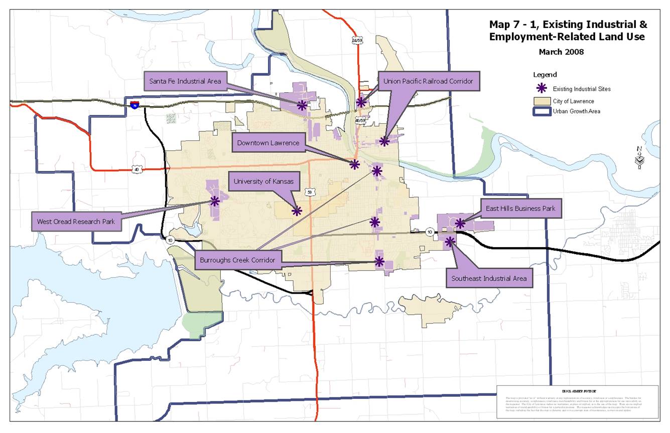
The City of Lawrence has several major industrial areas providing employment opportunities to the community. These larger areas include: 1) Santa Fe Industrial Area; 2) East Hills Business Park; 3) Santa Fe Railroad corridor; 4) Union Pacific Railroad corridor; 5) Lawrence Municipal Airport; and 6) Southeast Industrial Area. A description and plan recommendations for these areas are discussed below. In addition to these primary industrial areas, the City of Lawrence also has a number of smaller industrial locations throughout the city. While not specifically addressed in this section, these smaller industrial areas play an important role in the overall industrial and business development composition of the community as a whole. Refer to Map 7-1, Map of Existing Industrial and Employment-Related Land Uses.
· Santa Fe Industrial Area
The Santa Fe Industrial Area, located north of the Kansas Turnpike/I-70 and south of the Kansas River in north central Lawrence, has developed as a large warehouse and distribution location. This Comprehensive Plan recommends an expanded role for this area in the future. The area north of Lakeview Road may alternately develop with more traditional industrial uses. It is also recommended that as additional industrial-related uses develop, impacts on nearby residential development along Riverridge Road will need to be minimized. Additionally, street improvements may be needed and land use transition areas are recommended to protect residential uses in the area.
· East Hills Business Park
East Hills Business Park is located on the eastern edge of Lawrence on the north side of Kansas Highway 10. Planned and developed in the late 1980s and early 1990s, this is one of the community’s first true industrial park developments. As this area reaches capacity, the closure of the Farmland Industries site (immediately to the west) makes expansion of East Hills Business Park a possibility and should be closely examined for such a purpose. East Hills Business Park serves as the eastern gateway to the community and the City should continue to examine future development plans for this area to ensure they reflect the image and quality the community seeks in gateway development.
· Burroughs Creek Corridor
The Burroughs Creek Corridor (the former Santa Fe Railroad Corridor) stretches from East 31st Street to the Kansas River in East Lawrence and includes a south and north segment. Parts of the corridor area offer smaller land parcels and provides opportunities for small business owners to coexist with neighboring residential uses. Future development of this area should be in accordance with the Burroughs Creek Corridor Plan.
· Union Pacific Railroad Corridor
The Union Pacific Railroad Corridor serves North Lawrence and has historically been the site of a variety of industrial uses. Industrial development patterns along the corridor are somewhat fragmented with interspersed residential and commercial land uses. Many industrially zoned sites have been developed with residential structures or represent vacant lots originally divided for residential purposes. This corridor may also offer opportunities for small business owners to establish smaller industrial operations within the community.
New development and redevelopment in the area should be encouraged to improve the appearance and image of the area. In general, Locust Street, Maple Street, and Lincoln Street west of North 7th Street should continue to serve as industrial collector streets in the neighborhood. Efforts to discourage non-residential traffic in other parts of the neighborhood are highly encouraged. It is also recommended that consolidation of industrial sites occur whenever possible to remove those residential and incompatible commercial uses located within predominantly industrial development land use patterns in a concentrated effort to minimize those impacts and conflicts between incompatible land uses. When the industrial usage of a particular property ceases and is no longer practical, it is recommended those properties be converted to residential and/or neighborhood commercial uses.
LAWRENCE - NEW INDUSTRIAL AREAS
This chapter sets out goals and policies to guide present and future industrial and employment development within Douglas County. A key part of the chapter is deciding where Industrial and Employment related development should be located. To assist in the identification of general locations throughout the City of Lawrence, its Urban Growth Area, and unincorporated Douglas County appropriate for industrial and employment park development, there are some basic locational criteria characteristics that should be considered. The following criteria strike a balance between industrial user needs and community interests, as well as being aligned with criteria developed through the ECO2 process.
Locational Criteria for Industrial Developments
A given site, whether located within City limits, in the UGA, or in unincorporated areas of Douglas County, should substantially meet the following general locational criteria:
§ have feasible access to Federal and State transportation networks;
§ be of adequate parcel size, generally over forty acres;
§ lie primarily outside of the regulatory floodplain;
§ have minimal average slopes.
After identifying a general location for potential industrial and employment park development, further site analysis and environmental suitability should be conducted considering site-specific criteria. Sites should substantially meet the following specific criteria on a site plan or development plan level:
§ preserve environmentally sensitive areas, including vegetative cover and wildlife habitat, to act as buffers and site amenities;
§ encourage natural stormwater management, including locations that permit direct discharge to the floodplain;
§ have available and adequate utilities, infrastructure and services (i.e. police and fire protection) for the proposed use;
§ be compatible with existing and future zoning/land use patterns, including the use of appropriate buffers between land uses;
§ be annexed before development if adjacent to municipal boundaries.
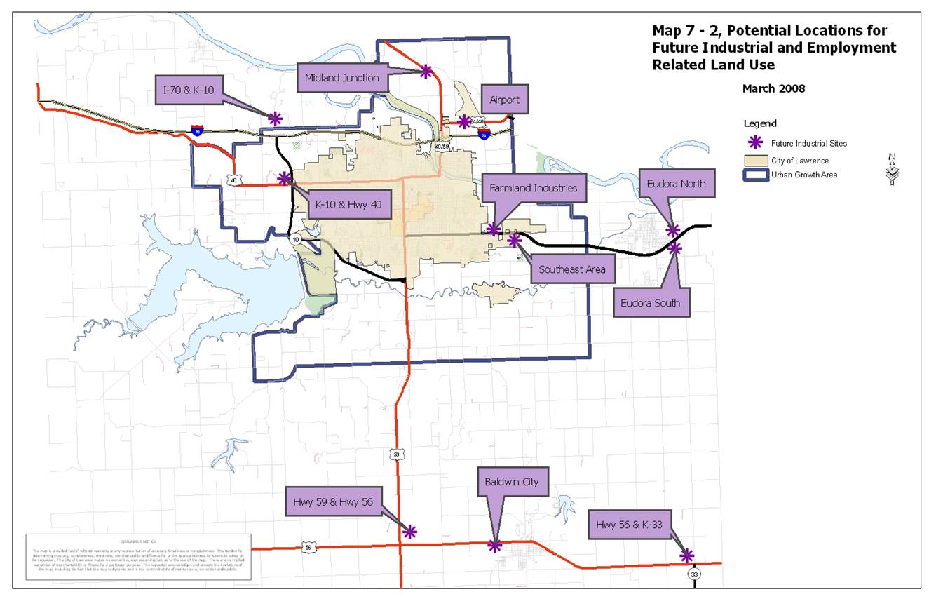
Initial applications for site considerations should first be weighted against the general locational criteria, and then against the specific criteria as individual proposals move through the development process. A non-exclusive list of sites that substantially meet the general criteria are illustrated in Map 7-2, Map of Potential Locations for Future Industrial and Employment Related Land Use, and are detailed in descriptions below. Locations initiated through the planning process that are not on Map 7-2 will be weighted against the general locational criteria above.
Individual Site Analysis:
· Farmland Industries
Transportation: State Highway and Rail access
Parcel Size: 275+ acres
Floodplain: None
Slope: Mostly minimal (0-3%) with some 3-7% and higher
Generally this area is located north of K-10, west of East Hills Business Park, south of N 1500 Road, and west of E 1575 Road. While the entire site contains roughly 400+ acres, the proposed Farmland Industries Redevelopment Plan, currently working through the approval process, identifies approximately 275 acres of land for industrial uses. The site has access to K-10 Highway, as well as possible future connections to East Hills Business Park. In addition the site has direct access to rail lines that exist on the north end of the property. The site lies outside of the 100-year floodplain and is generally covered by minimal (0-3%) slopes, with a few areas having 3-7% and higher slopes. Portions of the site pose some challenges related to environmental clean-up from the prior use that needs to be addressed before re-development, but would be a good site for Warehouse and Distribution, Office Research and Industrial uses, especially when combined in a collaborative park setting.
· Southeast Area
Transportation: State Highway access
Parcel Size: 200+ acres (with an additional 30 identified for Warehouse)
Floodplain: None
Slope: Minimal (0-3%)
The Southeast Industrial Area is located on the south side of East 23rd Street/Kansas Highway 10, south of East Hills Business Park. This area consists of general industrial land uses and it is anticipated this area will experience increased industrial development as noted in the Southeast Area Plan. That plan recommends less intense Industrial uses, such as Warehouse and Distribution and Office Research for approximately 30 acres south of N 1360 Road between E 1700 Road and E 1750 Road. The plan recommends more intense industrial uses for the roughly 200 acres for the area northwest of the intersection of 25th Terrace and Franklin Road, the area east of Franklin Road, north of E. 25th Street and N. 1360 Road, west of E. 1750 Road (Noria Road), and south of E. 23rd Street/K-10 Highway and the area north and south of Franklin Park Circle. Like East Hills Business Park, the Southeast Industrial Area will serve as the eastern gateway to the community. This site has access to Kansas Highway 10 and lies outside of the 100-year floodplain. The area is generally covered by minimal (0-3%) slopes.
· Airport
Transportation: Federal Interstate, State Highway, Air access
Parcel Size: 230+ acres
Floodplain: Approximately 10% of those 230 acres
Slope: Minimal; 0-3%
The Lawrence Municipal Airport, located in North Lawrence along US-24/40/59, is a newly developing industrial area of the community. Aviation enterprises are present and there is the potential for additional aviation and related enterprises. Currently, the airport is an island surrounded by some county industrial land use, but mostly agricultural land uses. As development continues to occur in neighboring Leavenworth County, the US-24/40/59 corridor will become a major thoroughfare. As the City begins initiating long-range planning activities for improved municipal services to and stormwater management within this area, development pressures will increase for this area. It is recommended by this Comprehensive Plan that annexation be a part of any industrial development proposed for this area. As this area evolves into a community gateway, development proposals are also encouraged to employ sound site planning and design principles to make this area an attractive one. Interfacings with surrounding properties and neighborhoods are also encouraged to minimize negative impacts and employ appropriate and compatible industrial and business activities.
The area around the Lawrence Municipal Airport best suited for industrial development generally lies southwest of the airport and North of I-70 and encompasses roughly 230 acres. This site has access to I-70, Highways 24 and 40, and the Lawrence Municipal Airport. The majority of the site lies outside of the regulatory floodplain; however, this site has unique challenges related to stormwater management that would need to be addressed during the development process. Slopes in this area are minimal (0-3%).
· I-70 and K-10
Transportation: Federal Interstate and State Highway access
Parcel Size: 150 acres, with possibility of more
Floodplain: None
Slope: Mainly 0-3%
The I-70 and K-10 area lies generally north of N 1800 Road (Farmer’s Turnpike) near the intersection of Kansas Highway 10 and I-70. The proposed area contains roughly 150 acres with the potential for more land to be identified for industrial and employment related land use through the long-range planning process. The area contains land of minimal slope (0-3%) and also lies outside of the 100-year floodplain. This area substantially meets the general locational criteria and will be an important future economic development area for the Lawrence community because of its prime location near the I-70 interchange, which also acts as the primary access point for the City of Lecompton. It may be possible to develop the site to a limited extent prior to the availability of urban services; however, intense development should wait until such time that the land is annexed and urban services are able to be provided. Over time, as this area develops, it will serve as a gateway to the City of Lawrence and would best be suited for Warehouse and Distribution uses, Industrial uses, Work-live Campus type centers and Industrial/Business/Research parks.
· K-10 and Highway 40
Transportation: State Highways (access to Federal Interstate within 2 miles)
Parcel Size: 300 Acres (split north and south of Highway 40)
Floodplain: None
Slope: Mainly 0-3%, with some 3-7%
This area generally lies to the west of K-10 Highway on both the north and south sides of Highway 40 and is detailed in the West 6th Street/K-10 Nodal Plan. The area contains approximately 300 acres and lies outside of the 100-year floodplain. The area is located adjacent to both Highway 40 and K-10 Highway, as well as being in close proximity to I-70. The site has mostly minimal slopes (0-3%) with some 3-7% slopes. Over time, as this area develops, it will serve as a gateway to the City of Lawrence and would be best suited for Warehouse and Distribution uses, Industrial uses, Work-live Campus type centers and Industrial/Business/Research parks.
· Eudora North & Eudora South
Areas have been generally identified on the east side of Eudora, both north and south of K-10 Highway that would be appropriate for Industrial development. It is recommended that Eudora annex both areas prior to development.
· Baldwin City
The Comprehensive Plan already identifies that a general area to the west of the current Baldwin City limits would be ideal for industrial development at such time that the City of Baldwin is able to provide utilities to the site. Baldwin City is currently in the process of drafting and adopting a comprehensive plan and therefore any decisions regarding specific locations for this site should wait until that process is complete.
· Highway 56 and Highway 59
The Comprehensive Plan identifies that a general area near the proposed intersection of Highways 56 and 59 would be ideal for industrial development in the future. It may be possible to develop the site to a limited extent prior to the availability of urban services; however, intense development should wait until such time that urban services are able to be provided.
· Midland Junction
This area generally lies near the intersection of N 2000 Road and Highway 24/59 north of Lawrence. While the area is located within the Urban Growth Area for the City of Lawrence, development is not anticipated for more than 30 years. This area is located in proximity to transportation networks and meets the general location criteria making it ideal for industrial development in the future. Intense development should wait until such time that urban services are able to be provided, and transportation infrastructure is upgraded to ensure safe access.
· Highway 56 and K-33
The Comprehensive Plan identifies that a general area near the intersection of Highways 56 and K-33 would be ideal for industrial development in the future due to its proximity to the proposed Gardner Intermodal Facility. It may be possible to develop the site to a limited extent prior to the availability of urban services; however, intense development should wait until such time that urban services are able to be provided.
The preservation of high-quality agricultural land, which has been recognized as a finite resource that is important to the regional economy, is of important value to the community. High-quality agricultural land is generally defined as available land that has good soil quality and an produces high yields of crops. Within Douglas County these are capability class (non-irrigated) 1 and 2, as identified by the National Resources Conservation Service.
Future Industrial and Employment land use sites not included on Map 7-2, Potential Locations for Future Industrial and Employment Related Development, should balance the agricultural significance on the site against the need for industrial and employment related development.
2. EMPLOYMENT-RELATED LAND USE
EMPLOYMENT-RELATED LAND USE CATEGORIES
Employment-related and business park development in Douglas County has taken on many shapes and forms in the past. This Comprehensive Plan recognizes this variety in development and establishes the following categories of employment-related land use:
n Office - an area generally characterized by a predominance of professional offices and service uses that are typically located in commercial areas.
n Office Research - an area generally characterized by businesses involved in technology, research, and scientific-related activities, although it may also include traditional light industrial uses, such as manufacturing or assembly.
n Work-live Campus-type Center – an area that is a campus-like setting with a mix of uses that are compatible which may include industrial, business, retail commercial and residential developments. These areas will be held to a higher standard of design that accents and complements the natural environment and provides a comfortable environment for a live-work relationship where pedestrian activity is planned for and encouraged.
n Industrial/Business/Research Park - an area generally characterized by a predominance of office, office research, warehouse and distribution, and/or industrial business activities that typically encompass a large area of land and are designed in a “campus” setting.
LAWRENCE - EXISTING EMPLOYMENT-RELATED AREAS
The City of Lawrence has several business areas providing employment opportunities to the community. Three of the larger areas include: 1) the University of Kansas; 2) downtown Lawrence; and 3) Oread West Research Park. A description and plan recommendations for these areas are discussed below. In addition to these primary employment-related areas, the City of Lawrence also has a number of smaller business locations throughout the city. While not specifically addressed in this section, these smaller business centers play an important role in the overall employment and business development composition of the community as a whole. Refer to Map 7-1, Map of Existing Industrial and Employment-Related Land Uses.
· The University of Kansas
The University of Kansas, with its main campus on the east side and its west campus on the west side of US-59/Iowa Street, serves as a major employment center for the City of Lawrence and Douglas County. As the university continues to grow and expand its research and technological abilities, opportunities for new and expanded related industrial and business development are a possibility and highly encouraged.
· Downtown Lawrence
Downtown Lawrence encompasses a significant number of non-retail employees and geographically represents a major employment area for the community as well. A substantial number of office and service employees are located in this area. The development of new major office employment centers within the community needs to be evaluated to determine the potential effect on downtown Lawrence. A critical assessment should be made to determine that such proposed development will not have a significant negative impact on the Downtown.
· Oread West Research Park
The Oread West Research Park, located at the intersection of Wakarusa Drive and Bob Billings Parkway (formerly West 15th Street) in West Lawrence, is one of the City's newest employment areas offering a high-quality development setting. Although this area has experienced continued development, vacant land still exists and this Comprehensive Plan recommends continued emphasis on office and research use for this area. The location has strong potential for new technology-related industries and should be the focus of an "industrial cluster" as described in the Economic Development element. This park has ties to the University of Kansas and a continued partnership in technological and research-based industrial and business opportunities is encouraged.
LAWRENCE - NEW EMPLOYMENT-RELATED AREAS
This Comprehensive Plan recognizes the need for smaller scale business development opportunities. The following discussion relates to the office and office/research uses of the employment-related land use classifications mentioned earlier.
· Office
New office uses will generally be restricted to existing areas of the city, or new areas that are appropriately identified on future land use maps. Future office uses should only locate in new industrial areas in partnership with office research areas, so that office uses independent of industrial uses do not take up valuable industrial land.
It is desirable that a mix of uses be established for these areas in a planned and unified manner. Like other locations visible from major street corridors, development of these areas should express a high quality living and working environment. Consideration of good site planning and design principles that minimize unnecessary impacts to surrounding neighborhoods and promote compatible land use activities and appropriate neighborhood connections and interfacings are encouraged for any development proposed for this area.
· Office Research
Office research uses have been recommended as an appropriate land use activity at gateways into the community. Developments occurring at gateways to the community are required to be of high-quality design and visual character utilizing best management practices for site planning and design. Such developments are intended to promote an integrated and contextual design approach that minimizes unnecessary impacts, such as noise, odor, glare, or other similar intrusions to the community and surrounding neighborhoods.
For information related to Work-Live Campus-type Centers and Industrial/Business/Research Park refer to the text in Section 1 - Industrial Land Use for recommendations relating to this type of land use.
INDUSTRIAL AND EMPLOYMENT-RELATED LAND USE GOALS AND POLICIES
|
Guidelines and incentives are needed to allow for the retention and expansion of development in established industrial and employment-related areas of the City of Lawrence and unincorporated Douglas County. |
GOAL 1: Development in Established Industrial and Employment-Related Areas
Encourage the retention, redevelopment and expansion of established industrial and employment-related areas.
Policy 1.1: Retain Established Development and Encourage New Development in Existing Industrial and Employment-Related Areas
a. Work with the Lawrence Chamber of Commerce to actively market undeveloped sites in a manner which will stabilize long-term development patterns.
b. Encourage parcel consolidation to provide infill sites for redevelopment and expansion opportunities.
c. Provide incentives for expansion of existing facilities and redevelopment of vacant facilities and/or land.
Policy 1.2: Ensure Compatibility of Development
a. Establish design guidelines and standards for redevelopment of existing sites and facilities to ensure high quality development.
b. Encourage best management practices for site planning and design that include, but are not limited to, building placement and orientation, vehicular and pedestrian circulation patterns, open space, landscaping, lighting, stormwater management, and interfacings with adjacent neighborhoods and development, and appropriate accommodation of the design to the site’s natural features.
c. Encourage building design techniques that include, but are not limited to, the consideration of facade and exterior wall articulation, materials and colors, rooflines, entryways, signage, and energy and resource conservation.
Policy 1.3: Concentrate Industrial and Employment-Related Development
a. Maintain an appropriate supply of industrially zoned land so that site choices are available and infrastructure expansion can occur in an efficient and orderly manner.
b. Services to existing industrial and employment-related areas should be improved and upgraded as required to support redevelopment opportunities. Overall stormwater management, vehicular and pedestrian access, water and wastewater abilities, and site maintenance should be undertaken where necessary. Encourage partnerships for redevelopment and improvements.
Policy 1.4: Provide Opportunities for Limited Industrial and Employment-Related Development in the Unincorporated Areas of Douglas County
Encourage redevelopment and limited expansion of existing industrial and employment-related areas where specific criteria (p. 7-5) can be met.
|
Guidelines are needed to provide direction on
how much, where and at what scale industrial and employment |
GOAL 2: Criteria for Location of New Industrial and Employment-Related Development
Provide industrial and employment-related areas to meet the economic needs of the community.
Policy 2.1: Utilize Locational Criteria for All Industrial and Employment-Related Development
1. A given site, whether located within City limits, in the UGA, or in unincorporated areas of Douglas County, should substantially meet the following general locational criteria:
a. have feasible access to Federal and State transportation networks;
b. be of adequate parcel size, generally over forty acres;
c. lie primarily outside of the regulatory floodplain;
d. have minimal average slopes.
2. After identifying a general location for potential industrial and employment park development, further site analysis and environmental suitability should be conducted considering site-specific criteria. Sites should substantially meet the following specific criteria on a site plan or development plan level:
a. preserve environmentally sensitive areas, including vegetative cover and wildlife habitat, to act as buffers and site amenities;
b. encourage natural stormwater management, including locations that permit direct discharge to the floodplain;
c. have available and adequate utilities, infrastructure and services for the proposed use;
d. be compatible with existing and future zoning/land use patterns, including the use of appropriate buffers between land uses;
e. be annexed before development if adjacent to municipal boundaries.
f. Utilize the following general locational criteria in reviewing industrial and employment-related development request.
Policy 2.2: Review Public Incentive Requests for Compliance with City Adopted Policies
Review public incentive requests to ensure compliance with city adopted policies.
Policy 2.3: Adhere to Designated Land Uses
a. Locate the development of planned industrial, office research and warehouse distribution facilities in accordance with the general locational criteria listed on p. 7-5. Additionally, sites that meet those criteria are identified on Map 7-2. Require annexation of sites that are adjacent to the City of Lawrence limits.
b. Designate new industrial, office research and warehouse distribution areas to support job creation. Ensure that new industrial, office research and warehouse distribution developments are concentrated in areas with similar compatible uses.
c. Large-scale industrial and employment-related development should be located in planned parks to help ensure coordination of circulation systems, lot configuration, site layout [building, parking and access facilities], and environmental amenities.
Policy 2.4: Maintain an Inventory of Industrial and Employment-Related Land Uses and Develop a Method to Monitor Related Growth
a. Maintain a methodology for site selection that takes into consideration industrial users needs and the best interests of the community.
b. Identify and plan for an appropriate supply of industrially zoned land.
c. Develop a technique to monitor the aggregate size of industrial and employment-related developments within the community.
Policy 2.5: Ensure Compatibility of Development
a. Establish design guidelines and standards for new industrial and employment-related development.
b. Encourage best management practices for site planning and design that include, but are not limited to, the consideration of natural site features, building placement and orientation, vehicular and pedestrian circulation patterns, open space, landscaping, lighting, stormwater management, and interfacings with adjacent neighborhoods and development.
c. Encourage building design techniques that include, but are not limited to, the consideration of facade and exterior wall articulation, materials and colors, rooflines, entryways, signage, and energy and resource conservation.
d. Major entrances into industrial and business parks should be identified by attractive "gateway" features. Gateways should include special signage, landscaping and accent lighting, and/or a common sculptural feature and should be located outside the public street rights-of-way.
e. Access to individual building sites within industrial and business parks should be from an internal circulation system. Site access from peripheral arterial and collector streets should be limited to major entrances serving the overall development area. However, industrial users on large lots that are significant generators of traffic may directly access arterial roads if the size of the site is such that it allows internal circulation without the necessity of constructing local roads to direct that circulation to the arterial road. Such access shall be based on sound traffic engineering principles and shall be properly controlled with appropriate signalization and turn lanes. Industrial and employment-related traffic and related conditions should not adversely affect other nearby land use areas.
|
Guidelines are needed to allow for compatible transition from industrial and employment-related development to other less intensive land uses. This framework is needed both in existing areas and new development areas. |
GOAL 3: Compatible Transition from Industrial and Employment-Related Development to Less Intensive Uses
Ensure a compatible transition between industrial and employment-related developments and less intensive land uses.
Policy 3.1: Use Appropriate Transitional Methods
a. Encourage industrial, office research and warehouse distribution facilities to have a positive impact on neighboring land uses through the use of natural area separations, broad landscaped yards or other means of buffering.
b. New industrial, office research and warehouse distribution facilities should be designed and developed so that offices, showrooms, and similar uses occupy high-visibility locations around park peripheries.
c. Less compatible development should be located to the interior of industrial and employment-related development sites or adjacent to arterial streets rather than adjacent or in close proximity to residential neighborhoods or incompatible commercial uses. A use may be considered less compatible because of height, massing, parking, and light, noise, traffic generation or hours of operation.
d. Compatible transition and appropriate interfacings from industrial and employment-related development to less intensive land uses should consider:
1. Site Orientation
a. Site design should be oriented toward major streets.
b. Site access should be from collector or access/frontage streets to arterials. However, industrial users on large lots that are significant generators of traffic may directly access arterial roads if the size of the site is such that it allows internal circulation without the necessity of constructing local roads to direct that circulation to the arterial road. Such access shall be based on sound traffic engineering principles and shall be properly controlled with appropriate signalization and turn lanes.
c. Streets which are designed with elements to provide visual or physical buffering may be used as boundaries between industrial and employment-related development and commercial or higher-density residential land uses.
d. Encourage the consolidation of access and driveways serving two or more uses within the industrial/business park development.
2. Building Relationships
a. A back-to-back relationship is preferable between industrial-related and residential uses, and may require substantial screening to provide compatibility. A front-to-front relationship is encouraged for all non-residential uses.
b. Industrial and employment-related buildings and parking areas should have greater setbacks than the required setbacks of abutting residential uses.
c. The height and massing of industrial and employment-related buildings and accessory structures should be oriented away from residential neighborhoods to avoid creating a negative visual effect. Industrial building height and massing should be complementary and reflect the residential architecture and neighborhood character when adjacent to such development.
3. Land Features
a. Retain mature trees, natural vegetation, natural and environmentally sensitive areas to naturally separate industrial and employment-related developments from residential land uses.
b. Use existing topography to naturally separate industrial and employment-related developments and other less intensive land uses.
4. Screening and Landscaping
a. Encourage the creative and extensive use of landscaping and berming techniques for effective buffering between differing intensities of land uses.
b. Fences shall not be used as a sole method of providing screening and buffering. Where fencing is proposed, additional landscaping may be required to soften the monotonous effect of a fenceline.
c. Encourage the use of existing vegetation, such as stands of mature trees, and other natural site features into the landscape design as natural buffers or focal points.
d. Use high quality materials in the construction of screening and landscaping to decrease long-term maintenance costs. Quality of site landscaping shall mirror the quality of the overall development.
e. Unsightly views and light trespass should be screened from neighboring properties and the public right-of-way. Building materials or structures incompatible with the image of a high-quality development, such as chain-link fences, outdoor storage facilities, etc., should not be the means of screening areas visible from public streets or adjacent parcels.
5. Lighting
Any lighting used to illuminate parking areas, signs or structures shall be placed to deflect light away from any adjoining property or from public streets through fixture type, height and location.
Policy 3.2: Consideration of Transitional Uses
a. Consider low-intensity commercial or office development as a transition between industrial and employment-related development and low-density residential neighborhoods. The low-intensity commercial or office development should include:
1. Design elements such as: height, massing, and scale compatible with the surrounding low-density residential uses;
2. Site design compatible with surrounding residential neighborhoods with consideration given to extensive screening, building and parking orientation, and preservation of natural site amenities; and
3. Site access provided from arterial, collector or access/frontage streets and traffic directed away from surrounding residential areas.
b. Encourage the integration of higher-density residential development through compatible design with industrial and employment-related developments and the surrounding low-density residential neighborhoods. Compatible design includes proper building transition and buffers.
c. Utilize medium- or high-intensity recreational facilities as a transitional use to lesser-intensity uses. Encourage the joint use of parking facilities to serve the recreational uses.
d. Incorporate open spaces and natural site features as a transitional use between industrial and employment-related development and low-density residential development.
Policy 3.3: Consider Image and Appearance in Site Layout
a. Establish design guidelines and standards for new industrial and employment-related development.
b. Encourage best management practices for site planning and design that include, but are not limited to, the consideration of natural site features, building placement and orientation, vehicular and pedestrian circulation patterns, open space, landscaping, lighting, stormwater management, and interfacings with adjacent neighborhoods and development.
c. Encourage building design techniques that include, but are not limited to, the consideration of facade and exterior wall articulation, materials and colors, rooflines, entryways, signage, and energy and resource conservation.
|
Traffic impacts continue to be a major concern in industrial and employment-related developments, with much of the concern related to ensuring safe and efficient access and circulation within and around industrial and employment-related areas. |
GOAL 4: Transportation Considerations
Promote a multi-modal transportation system which provides or improves access and circulation within and adjacent to industrial and employment-related areas.
Policy 4.1: Level of Service
Permit the expansion of existing or construction of new industrial and employment-related development in areas where the additional traffic generated by such development would result in an acceptable Level of Service.
Policy 4.2: Evaluate Traffic Impacts
An evaluation of the traffic impacts of a development on the surrounding area should consider the existing and projected traffic conditions and their impact on the existing transportation system and should be based on planned improvements which are identified in the Capital Improvement Plan (CIP), the Comprehensive Plan, or the Long-Range Transportation Plan. The Capital Improvement Plan, the Comprehensive Plan, and the Long-Range Transportation Plan shall be updated periodically to recognize changes in priorities and to add new projects with designated priorities.
Policy 4.3: Vehicular Circulation and Access
a. Require, wherever possible, vehicular circulation within compatible developments that allows internal access to adjacent industrial and employment-related buildings and developments.
b. Prohibit direct vehicular access from industrial and employment-related developments to local residential streets. Industrial and employment-related traffic through residential areas is strongly discouraged.
c. Limit the principal access for industrial and employment-related centers to arterial, collector or access/frontage roads. Industrial users on large lots that are significant generators of traffic may directly access arterial roads if the size of the site is such that it allows internal circulation without the necessity of constructing local roads to direct that circulation to the arterial road. Such access shall be based on sound traffic engineering principles and shall be properly controlled with appropriate signalization and turn lanes.
d. Adequate ingress and egress from industrial and employment-related centers should strive to provide a minimum of two access points.
e. Encourage shared access between adjacent industrial and employment-related developments. Plan for coordinated traffic circulation within and adjacent to proposed development areas.
Policy 4.4: Pedestrian Access and Circulation
a. Provide sidewalks on both sides of all streets (public and private).
b. Provide safe, convenient pedestrian access from parking areas and avoid pedestrian and vehicular conflicts within these industrial and employment-related developments.
c. Include bicycle access, or the potential for such access, within industrial and employment-related developments, between major employment areas within the community, and with the community’s overall bicycle network.
d. Strongly consider public transit facilities and pedestrian-related facilities as a requirement of industrial and business park development.
e. Encourage public transit.
Policy 4.5: Parking and Loading
a. Develop parking areas in convenient locations to support industrial and employment-related traffic.
b. Identify potential parking areas which will serve mass transit and carpooling.
c. Ensure adequate loading space, within a building or a side or rear yard, in such a way that all storage, standing and maneuvering of trucks will take place solely on private property and be screened or buffered from adjacent lower-intensity uses.
This page intentionally left blank
Appendices for supplemental reports
This page intentionally left blank.