|
PLANNING COMMISSION REPORT Regular Agenda - Public Hearing Item |
|
ITEM NO. 13 A TO IG; 155 ACRES; I70/K10 BUSINESS PARK (SLD)
Z-04-09-08: A request to rezone approximately 155 acres from A to IG. The property is located on the NW Corner of N 1800 Rd & E 900 Rd; I70/K10 Business Park. Submitted by Steven Schwada, agent for Stonewall Farms LLC; JDS Kansas LC; Pert LC; Penny J Tuckel; Axrom LLC; Venture Realty Corporation; Arco Sales Corporation; Venture Properties Inc; Industrial Square Corp; JDSS Limited Company; Radol LC; Tuckel Russell L JR; Northland Ventures LC; and Oread LC, property owners of record.
|
|
STAFF RECOMMENDATION: Staff recommends approval of the request to rezone approximately 154.9 acres, from A (Agricultural) to IG (General Industrial) based on the findings presented in the staff report and forwarding it to the City Commission with a recommendation for approval.
Subject to the following conditions:
|
|
Reason for Request: |
Following the Planning Commission’s December 17, 2007 recommendation for approval of this tract to County Zoning I-2, City Staff requested annexation into the City, the owners agreed and the Planning Commission on March 26, 2008 recommended annexation. Annexation requires a zoning designation. This request fulfills that requirement. |
|
KEY POINTS · The property is subject to annexation. · The subject property is located within 3 miles of the cities of Lawrence and Lecompton. · The property has immediate access and proximity to improved arterial street and highway network (N 1800/Farmer’s Turnpike and I-70/K10 Lecompton Interchange). · Previous land use requests for county industrial zoning and annexation have been positively recommended by the Planning Commission. · The County Commission made a finding on May 14, 2008 that the proposed annexation of the subject property will not hinder or prevent the proper growth and development of the area, or that of any other incorporated city located within the County. · The City Commission directed staff on 6/17/08 to prepare an ordinance for approval of the requested annexation. · Draft Chapter 7, Horizon 2020 supports industrial use in this area and has been recommended for adoption by the Planning Commission. · Draft K-10 & Farmer’s Turnpike Plan has been initiated and supports industrial use in this area. · Transportation 2030 was recently adopted and took into account industrial use in this area. |
|
|
|
ASSOCIATED CASES/OTHER ACTION REQUIRED
|
|
PUBLIC COMMENT RECEIVED PRIOR TO PRINTING · Oscar C. “Bud” Nation, 811 N. 1710 Road, letter dated May 30, 2008.
|
|
ATTACHMENTS · Page Map · Existing Industrial Areas Pre 2006 zoning · Existing Industrial Areas current zoning · Industrial district comparison table · Definitions of industrial districts
|
Project Summary:
The subject property includes 16 separate parcels ranging from 5 acres to 23 acres, under a multiple ownership arrangement, with frontage to abutting County roads. The proposed request is for rezoning the property to IG for industrial uses. A summary of the industrial district is attached comparing the three different industrial districts in the code. Per Section 20-1303 of the Development Code the following criteria for evaluation shall include the following factors:
1. CONFORMANCE WITH THE COMPREHENSIVE PLAN
Applicant’s Response:
”On December 17, 2007 the Planning Commission found that an industrial site on this tract was in conformance with the Comprehensive Plan.”
The Plan establishes the Urban Growth Area for the City of Lawrence and supports development within that area in a planned manner with attention to annexation and the availability of urban services and infrastructure – specifically water and wastewater treatment service.
Map 3-1 shows the subject property as being located in the Rural Area, outside of the Urban Growth Area.
Chapter 6 of Horizon 2020 indicates a future auto related center located at the I-10/K10 interchange –in Map 6-1. This general location is south of the subject property. Recommended location criteria for such uses is identified as locations at the intersection of two state or federally designated highways and specifically designates the intersection of I-70 and K-10 as a potential for a new Auto-Related Center. These locations are also identified as “gateways” into the City” and as such “shall be closely scrutinized for architectural appearance, landscaping, signage, etc.” Page 6-6
Goal 3: Criteria for Location of Industrial or Employment-Related Development.
The purpose of this goal is to set “guidelines to provide direction on how much, where and at what scale industrial or employment development is appropriate for the market it is intended to serve.” (Page 7-11)
Specific policies of this section “encourage industrial development in the UGA’s.” (Policy 3.1 (a)); “Development shall have internal site access” (Policy 3.1 (b)); and Ensure such developments are concentrated in areas with similar compatible uses” (Policy 3.1(c)).
Policy 3.1 (e) lists the criteria for evaluating locations:
- Limit development to designated areas as indicated on the Future Land Use Map and/or Sector Area Plan Maps.
- Encourage the formation of unified light industrial corridors through infill development of existing industrial areas.
- Promote the assembling of small tracts to form larger, more cohesive parcels, encouraging well-planned and orderly clusters of industrial development.
- Light industrial development should be located on arterial streets.
- Encourage industrial development to locate on sites having minimal slope to avoid substantial disruption of natural drainage and vegetation.
- Retain stands of mature trees, natural vegetation and environmentally sensitive areas to act as natural buffers between developments and as site amenities within developments.
The subject property is adjacent to a hard surface arterial road on the south side and local roads on the north and east side. Access is intended to provide a primary way into an industrial site with interior circulation for individual lot access. The subject property benefits from the location and proximity to the Lecompton Interchange with I-17/K10 highways.
Other policies address site design issues such as building orientation and screening that would need to be evaluated with a specific development proposal in concert with the Development Regulations of the City of Lawrence. Detailed plans for the development of the subject property are required to accommodate transition of the subject property into the City compliant with minimum stormwater, access management, and utility service standards.
Horizon 2020 – Chapter 7 Industrial and Employment-Related Land Use
Existing: The existing Chapter 7 of Horizon 2020 does not include the general area of the subject property as a future industrial site. The plan supports the development and increase in the number and diversity of jobs for the entire community (Douglas County as a whole) and as such is a key strategy of the existing chapter. The chapter, as currently adopted, does not support industrial use in this location.
Horizon 2020 – Draft Chapter 7 Industrial and Employment-Related Land Use
Draft: The revised Chapter 7, considered by the Planning Commission on March 26, 2008 was recommended for approval. The City Commission considered the proposed language on June 10, 2008 and deferred the proposed comprehensive plan text amendment. The revised chapter brings together the importance of the natural environment and a diversified economy as a tool for development considerations. A key feature of the draft plan is to: encourage site improvements, and community amenities which best respond to the market demands for industrial and business development while maintaining the community objectives for the type and quality of such development. The chapter also defines various types of industrial uses. A specific development application has not been submitted, but preliminary discussions of a warehouse and distribution use have been presented to city staff and others.
The draft Chapter 7 provides location criteria for new industrial areas and includes 150 acres identified I-70 and K-10. The plan specifically states:
|
I-70 and K-10
Transportation: Federal Interstate and State Highway access Parcel Size: 150 acres, with possibility of more Floodplain: None Slope: Mainly 0-3%
The I-70 and K-10 area lies generally north of N 1800 Road (Farmer’s Turnpike) near the intersection of Kansas Highway 10 and I-70. The proposed area contains roughly 150 acres with the potential for more land to be identified for industrial and employment related land use through the long-range planning process. The area contains land of minimal slope (0-3%) and also lies outside of the 100-year floodplain. This area substantially meets the general locational criteria and will be an important future economic development area for the Lawrence community because of its prime location near the I-70 interchange, which also acts as the primary access point for the City of Lecompton. It may be possible to develop the site to a limited extent prior to the availability of urban services; however, intense development should wait until such time that the land is annexed and urban services are able to be provided. Over time, as this area develops, it will serve as a gateway to the City of Lawrence and would best be suited for Warehouse and Distribution uses, Industrial uses, Work-live Campus type centers and Industrial/Business/Research parks. |
Staff Finding – As noted in the previous staff report related to the recent request to rezone to a county zoning district, many policies of Horizon 2020 do not support this request given its location outside of the Urban Growth Area and the lack of urban infrastructure available to the property. However, the Planning staff, under direction of the governing bodies of the county and city, is actively working to update the elements of the comprehensive plan that lend support to this request. The draft Chapter 7 supports the subject property for industrial development and a sector plan was initiated by the Planning Commission that, in its draft form, supports industrial and employment based land uses.
Finding by PC on December 17, 2008, as adopted from applicant’s submitted findings:
Horizon 2020 identifies several strategies for the development and maintenance of industrial areas. Horizon 2020, at page 7-1, states:
The principal Comprehensive Plan strategies for the development and maintenance of industrial areas are:
· Strive to increase the number and diversity of jobs available to citizens of Douglas County, with the intent of stabilizing the future employment base and generate additional wealth in the community. This strategy requires the community to make available an adequate amount of land in a number of locations to meet diverse development needs. The plan designates and encourages the development of a number of employment areas.
· Increase the community’s involvement in economic development in order to secure a job growth goal of 20,000 total new jobs in Douglas County by the year 2020. The plan encourages the continued cooperation of the local business community and area educational institutions to bring new technology and investment to the community.
· Recognize the need to protect, enhance and retain existing industrially related land use areas serving the community.
· Continue to address the needs of existing local employers and industrialists to ensure their retention and to facilitate expansion plans for the future.
· Work with developers and industrialists to make available sites, improvements and amenities which best respond to the market demands while meeting community objectives for the type and quality of development.
· Provide employment locations in various parts of the community and encourage bicycle and pedestrian access improvements to employment centers from community neighborhoods.
Horizon 2020 recommends (not requires) that industrial areas be annexed into the City of Lawrence. Douglas County's Home Occupations regulations were initiated to stop the proliferation of small industrial type home occupations throughout the county. These small businesses have started in individuals' driveways and barns because the individuals needed a low cost/low overhead opportunity to start a new business. Many of these businesses and other similar start-up businesses need industrial sites in the unincorporated areas of the County that are close to major transportation routes and that are not too expensive. These young, home grown enterprises need industrial sites such as those that will be offered at the subject property. This proposed business park will provide diversity in the 5 types of business/industrial parks the community can offer. There is no similar business park in Douglas County now. On the other hand, we have no large site to show to a prospective warehouse distributor such as Target that has as good access to all major transportation routes without traveling through residential areas of Lawrence. Because of our proximity to both Topeka and Kansas City, this is an ideal location with immediate and direct access to K-10 and I-70. From this location, one can get from the west side of Lawrence to the east side without having to use already overburdened city streets such as 23rd Street and Iowa, to gain access to U.S. 24 or 59, K-10 or I-70. Chapter 7, Goal 3 and the policies that support it are found on pp. 7-12 to 7-14.
Chapter 7, Goal 2 on Horizon 2020, pp. 7-9 to 7-11, and the policies that support it, provide the necessary safeguards to achieving a compatible transition from industrial/employment-related development of less intrusive uses. This goal and these policies should be applied to the site plan and plat that will follow the approval of the industrial zoning designation.
This application complies with the policies for the location of industrial or employment related development. It specifically complies with Horizon 2020, Policy 3.1, at page 121, which sets out the locational criteria for all industrial or employment-related development. The site is adjacent to the urban growth area and it is clear that the future land use map had not contemplated the rate of growth to the west of Lawrence and the need for an employment center in this part of Douglas County. The request meets the policies for good locational criteria. The access to each business will be from internal circulation, with shared direct access only onto an arterial (N. 1800 Road). (Policy 3.1(b)). The site is large enough to ensure that new industrial developments are concentrated in the area with similar compatible uses (Policy 3.1(c)). It will take approximately 10-25 years to fully develop this park. The site plan will ensure that the major entrances will be developed as gateways (Policy 3.1(d)). This will allow for well planned and orderly cluster development (Policy 3.1(e) (3)). It will be located on an arterial street (Policy 3.1(e) (4)). The site plan will avoid substantial disruption of drainage and will retain mature trees and natural vegetation as much as possible (Policy 3.1(e) (5) and (6)).
The subject property is also consistent with the following locational policies for designating industrial parks. It will be site planned as a planned industrial park that will support job creation for the next 10-20 years, while coordinating the circulation systems, lot configurations, site layouts and environmental amenities of the park (Policy 3.3).
The zoning of this tract will allow the County to have and maintain an appropriate supply of industrially zoned land so that site choices are available, in a diversity of areas, and infrastructure expansion can occur in an efficient and orderly manner. (Policy 3.4). Such a site would have allowed Douglas County to compete for a large warehouse distribution center that recently located in Topeka.
This unique location satisfies the major traffic impact concerns addressed by Horizon 2020 that accompany most industrial areas. The site will meet Chapter 7, Goal 4 Transportation Considerations set out on pp. 7-15 to 7-16. It will provide the best access and circulation within and adjacent to an industrial area that is possible in Douglas County (Goal 4). The anticipated levels of service on N. 1800 Road, K-10 and I-70 will not be negatively impacted by this industrial park (Policy 4.1). This site will neither permit direct vehicle access to local residential streets nor allow new industrial traffic through residential neighborhoods (Policy 4.3). This site will provide a minimum of two access points on an arterial road (Polices 4.4 and 4.5). The internal circulation will provide access to adjacent industrial buildings (Policy 4.6). The site plan will ensure safe pedestrian and bicycle access (Policies 4.7 and 4.8). The site is large enough to support adequate internal parking, truck loading and maneuvering areas (Policies 4.9 and 4.11).
Additionally, Horizon 2020, Chapter 12 - Economic Development Goals and Policies at pp. 12-1 to 12-10 are met with this application; which if granted, will provide for an additional location in which to increase job growth in Douglas County over the next 10-25 years, in a business park with unique access that will be developed privately. This application serves the purpose of increasing job growth, increasing the tax base and increasing livable wages (Goals 1, 2 and 3 on p. 12-1).
The fact that our population and housing have grown at a faster rate than our net job growth, requires us to increase the rate of job growth by expanding our economic development efforts. We need this additional business park as a way to attract new businesses to Douglas County locations, by meeting the market demand.
2. ZONING AND USE OF NEARBY PROPERTY, INLCUDING OVERLAY ZONING
|
Current Zoning and Land Use: A (Agricultural); undeveloped agricultural property |
|
Surrounding Zoning and Land Use: A (Agricultural) District; existing fields and crop land including rural residential homes located along existing County roads. |
The subject property is surrounded by agricultural zoning and uses. Other uses include homes on residential parcels adjacent to the existing county roads and interstate and state highways. Foley Excavation is located to the north of the subject property. This business has operated since prior to the 1966 zoning code and is designated as a legal non-conforming use. The subject property abuts N 1800 Road (Farmer’s Turnpike) a county principal arterial street. There are a total of 10 homes that face the subject property. Three parcels with existing residential homes are located to the south of the subject property. Farther to the south is Highway 70. The Highway interchange is located to south of the southwest corner of the subject property. Seven residential homes have driveways to E 900 Road or N 1850 Road that are across from the subject property.
Existing agricultural uses are designated as grassland (a pasture designation) by the County Appraiser’s Office. Areas to the far north are zoned A-1, a suburban home residential district, and are platted as Twin Ridge Heights Subdivision. A-1 zoning can also be found to the east and southeast of the subject property. (Refer to page map for zoning)
Staff Finding – The surrounding area is zoned A (Agricultural). Uses include pasture land and rural residential homes along the existing County roads. All of the properties surrounding the subject property are zoned A (Agricultural) District with a number of single-family homes developed on large tracts of land.
Finding by PC on December 17, 2008, as adopted from applicant’s submitted findings:
The present zoning of the surrounding properties to the east, west, north and south is
A (Agricultural) District with a few rural residences. This is typical of the agricultural and
residential zoning surrounding the other existing industrial parks in Douglas County, that are at or near the City's limits, such as; East Hills, Riverside, Anna Hope, Franklin Park, South Haskell, the airport and others. The surrounding uses are pasture, rural residential sites and some home occupations. The area is in transition from large farms to scattered rural residential and businesses on small lots near the City limits and adjacent to the urban growth area. The county roads to the north and east of the site are gravel. Pasture land adjoins the site to the west. The site is bounded on the south by N. 1800 Road. This road is a newly improved three lane arterial road that also serves the industrial areas 3.5 miles to the east (Riverside, Anna Hope). N. 1800 Road serves major truck traffic generators such as Lawrence Paper Co., Kansas Power and Light, Standard Brands, Classic Eagle Distribution, K-Mart Distribution, Berry Plastics, Reuter Organ, Heinz and others.
3. CHARACTER OF THE NEIGHBORHOOD
Applicant’s Response:
”Refer to December 17, 2007 Planning Commission findings.”
The neighborhood at present is dominated by agricultural uses and rural homes as well as a principal arterial street and interstate highway. N 1800 Road is an existing east/west thoroughfare for Douglas County. This road marks the north boundary of the Lawrence Urban Growth Area for this area. The subject property lies adjacent to but outside of the Urban Growth Area. Single-family homes are located across from the subject property on tracts of land that range from 2.2 acres to 99+ acres. This summary excludes the two parcels located to the east and the northeast because the structures are more than one-quarter mile distant from the subject property. Other uses include pasture and a home occupation for an excavating business that accommodates the storage of trucks and equipment associated with the home occupation.
Staff Finding –The character of the area is dominated by agricultural uses including rural residential home sites and a substantial road and highway network. Approval of the request and implementation of the sector plan will alter the character of the area. The application of the City Development Code protections will provide land use transition and buffer standards between adjoining land uses.
Finding by PC on December 17, 2008, as adopted from applicant’s submitted findings:
The subject property is located at the north side of the T-intersection of Kansas State Highway K-10 and newly improved County Road N. 1800 Road. It is approximately 1000 feet along an expressway (K-10) from the intersection of that expressway and an interstate highway (I-70). It is anticipated that truck traffic and most automobile traffic will leave the subject property and head south to K-10 and/or I-70. This extraordinary accessibility to the major roads surrounding Lawrence is unique in Douglas County.
The area is served by rural water, with a water tower and fire department across N. 1800 Road to the southwest. There is sufficient acreage on site to store any additional water that may be required. An on-site domestic wastewater lagoon will be retired and converted to building sites when city sewers are available. In the meantime, the lagoon will be regulated by the Kansas Department of Health and Environment (“KDHE”) and monitored by Douglas County. The owners will impose restrictive covenants as they have in other industrial developments and will limit the uses in the business park to non-polluting, non-objectionable uses.
4. PLANS FOR THE AREA OR NEIGHBORHOOD, AS REFLECTED IN ADOPTED AREA AND/OR SECTOR PLANS INCLUDING THE PROPERTY OR ADJOINING PROPERTY
The Planning Department and the community are actively involved in the development of a sector plan for the area. This plan will designate land uses for over 4,000 acres, much of which is within the current Urban Growth Area. The plan contemplates industrial development within the vicinity of the subject property to reflect the goals of Chapter 7 and the work of the Eco 2 committee’s recommendations.
The plan includes recommendations regarding land use transition that would be applicable along the north portion of the subject property to provide buffering between planned industrial development at the subject site and residential uses to the north. Ultimate plans include industrial uses to both the east and west thus the need for transition is reduced except that there are existing residential homes in the immediate area in the interim period of the plan.
Specific policy statements included in the draft plan state:
3.1.2.9 Transition Area (Page 3-4; Draft 5/23/08)
- The transition area shown on Map 3-1 should incorporate extraordinary buffers between industrial and residential uses in the form of landscape buffer yards to a minimum of double that required in the Land Development Code.
- All land uses within the identified transition area shall bare the burden providing the extra buffer.
- Transitions shall be incorporated into developments regardless of whether the abutting property is located within the city of Lawrence or unincorporated Douglas County.
3.2.1.8 Industrial (Page 3-10; Draft 5/23/08)
The intent of the industrial use is to allow for moderate to high-impact uses including large scale or specialized industrial uses geared toward utilizing K-10 Highway and I-70 for materials transportation.
Intensity: Medium-High
Applicable Area:
· Area generally between N 1800 Road (Farmer’s Turnpike) and N 1850 Road and E 800 Road and E 950 Road.
· Area between N 1800 Road (Farmer’s Turnpike) and I-70 and E 900 Road extended and E 950 Road extended.
Zoning Districts: IBP (Industrial and Business Park District) IL (Limited Industrial District), IG (General Industrial District), PD (Planned Development Overlay)
Primary Uses: Utility facilities, building maintenance services, fleet storage, business support services, construction sales and service, industrial facilities, wholesale, distribution, and storage, research services, manufacturing and production limited and technology
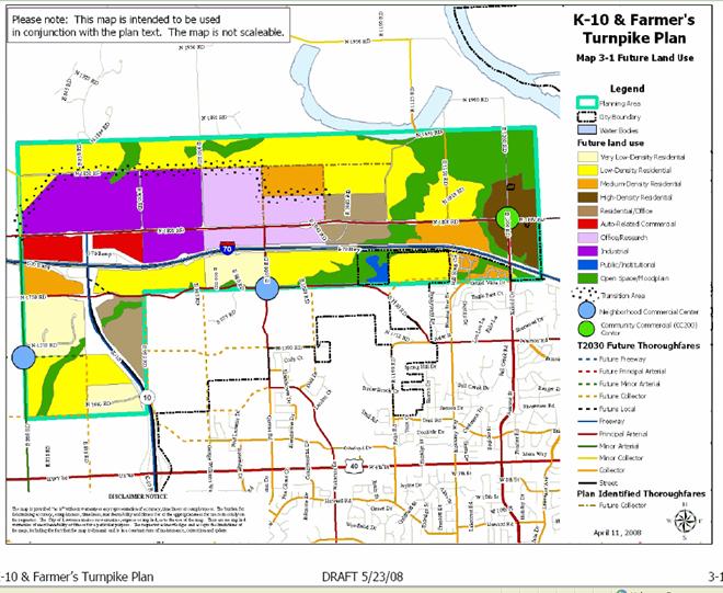
If approved, the subject property would be located within the area identified for industrial uses. Commercial uses are identified for the immediate intersection of I70 and K-10 south of the subject property. Prior to the development of the draft K-10 & Farmer’s Turnpike Plan, no specific neighborhood or area plan had been proposed for the area.
Staff Finding – The subject property complies with the draft sector plan as described. The draft plan reflects the goals of Chapter 7 and the Eco 2 committee to establish sites that would support industrial and employment based uses. However, it is fair to state that this draft plan has had little public input to date and is under consideration by the Planning Commission at this time.
5. SUITABILITY OF SUBJECT PROPERTY FOR THE USES TO WHICH IT HAS BEEN RESTRICTED UNDER THE EXISTING ZONING REGULATIONS
Applicant’s Response:
“Refer to December 17, 2007 Planning Commission findings.” Applicant’s Response from Z-10-37-07: “Continued growth of the City of Lawrence as well as its infrastructure suggests alternative uses are also appropriate for the subject property. Rural development to the north and city growth to the east and south position the property in an area of progressively less agricultural use.”
The subject property is used for pasture and there is no evidence to suggest that the property is not suitable for this use. However, the property is also suitable for industrial uses as outlined in draft Chapter 7 of Horizon 2020 given its location relative to the interstate, its topography, and its large size.
Staff Finding –The subject property is suitable for its present use and for moderate to high-impact uses including large scale or specialized industrial uses geared toward utilizing K-10 Highway and I-70 for materials transportation as stated in the draft K-10 & Farmer’s Turnpike Plan, page 3-10. The proximity of the subject property to transportation facilities is consistent with location criteria for intensive land uses that require convenient access such as industrial uses.
Finding by PC on December 17, 2008, as adopted from applicant’s submitted findings:
The subject property is currently zoned A (Agricultural) District. According to the Soil Survey of Douglas County, 1977, soils found on this property are generally classified as Martin-Sogan-Vinland. These soil types are typical of pasture land. The subject property has been and continues to be used for pasture. It is not suitable for cultivation of crops. It is suitable for building sites and can easily be modified to meet all percolation requirements for a wastewater lagoon regulated by KDHE. The proximity of the property to N. 1800 Road, K-10 and the K-10/I-70 interchange makes this property uniquely suited to serve businesses and industries with a need to access these major routes to distribute their goods and services. It is unlikely, given the developing pattern of small lot rural residential and ranchettes in the area, that larger tracts such as this one, will remain pasture land for very long. Given its location on the western edge of Lawrence and its direct access to the major county, state and interstate highways in Douglas County, it is uniquely suited for a business/industrial park. It is not yet surrounded by the rural residential development that exists to the north of this site.
6. LENGTH OF TIME SUBJECT PROPERTY HAS REMAINED VACANT AS ZONED
Applicant’s Response:
”Refer to December 17, 2007 Planning Commission findings.”
According to the Soil Survey of Douglas County, the soil found on the subject property is from the Martin-Sogan-Vinland Association, which is “Deep, moderately well drained, gently sloping to strongly sloping soils and shallow, sloping to moderately steep, somewhat excessively drained soils; on uplands.” The survey also indicates that about 55 percent of the acreage of this association is used for pasture, 35 percent for cultivated crops, and 10 percent for urban purposes and recreation. Livestock farming and general cash-grain farming are the main enterprises with wheat, soybeans, grain sorghum, and corn as the main crops. Staff understands that the subject property has been used for agricultural purposes since at least 1966, when County zoning regulations were adopted.
The subject property is predominantly vacant and is not served by urban services, which has and will restrict certain development opportunities at the property.
Staff Finding – The subject property is vacant except for a 110’ by 24’ utility storage shed that has been located on the south side of the property since 1956 according to Appraiser Office records.
Finding by PC on December 17, 2008, as adopted from applicant’s submitted findings:
This property has been zoned for agricultural uses since 1966 when the County adopted zoning regulations for the unincorporated areas of the County.
7. EXTENT TO WHICH APPROVING THE REZONING WILL DETRIMENTALLY AFFECT NEARBY PROPERTIES
Applicant’s Response:
“None is anticipated. Refer to December 17, 2007 Planning Commission findings.”
Approval of the proposed zoning will alter the character of the surrounding area by allowing for development of non-residential uses. Industrial development will result in increased traffic and light for the surrounding area, though N 1800 Rd currently carries large volumes of truck traffic. These attributes are typically considered to be undesirable to home owners. Development code protections such as building setbacks, densely landscaped buffer yards, and extraordinary peripheral setbacks can mitigate these impacts.
The impact of truck traffic can be mitigated with appropriate site design that will place access points only onto N 1800 Road, which will lead directly to I70.
Approval of the rezoning request will allow for a wide range of land uses of a higher traffic generating capacity than exists currently. Development of the site will require analysis of traffic and any necessary improvements such as deceleration lanes and or traffic lights depending on the proposed development.
Staff Finding – Impacts to nearby properties may include increased noise, light and truck traffic. Implementation of recommended plan polices and the development code standards are required to mitigate impacts to existing residential uses and to plan/accommodate future urbanization of the area.
Finding by PC on December 17, 2008, as adopted from applicant’s submitted findings:
Rezoning the subject property will not significantly affect the properties to the north, east or west, because the subject property is high and rolling and well screened with natural vegetation. N. 1850 Road, E. 900 Road and E. 800 Road are currently gravel roads on the north, east and west of the subject property. None of these roads will have direct access to the subject property. The site plan for this property will address buffering and screening of the businesses on the subject property and the preliminary plat for this site will restrict access from this tract to two drives on N. 1800 Road. The two rural residential properties south of the subject property between N. 1800 Road and I-70 are planned as commercial and residential in Transportation 2025. It is not anticipated that a business/industrial park would have a detrimental affect on any property on the south side of the arterial N. 1800 Road, but especially not on the planned commercial property.
8. THE GAIN, IF ANY, TO THE public health, safety and welfare due to the denial of the application, as compared to the hardship imposed upon the landowner, if any, as a result of denial of the application
Evaluation of this criterion includes weighing the benefits to the public versus the benefit of the owners of the subject property. Benefits are measured based on anticipated impacts of the rezoning request on the public health, safety, and welfare.
”Refer to December 17, 2007 Planning Commission findings.” Applicant’s Response from Z-10-37-07:“Currently undeveloped land will be improved and maintained as a result of the proposed change. Additionally, a growth in the County tax base as well as an increase in employment opportunity will be expected from new business development.”
Denying the application would maintain status quo for the neighborhood. If external impacts are mitigated through proper site design and code requirements, then impacts will be minimal and any gain to maintain status quo will be offset by the gain to the region by creating additional industrial sites properly located in the region.
Staff Finding – Approval of the requested zoning allows for a wide range of development options. Long term benefits identified are primarily the potential increase in tax base and industrial inventory and opportunities for development of employment related uses. If proper site planning techniques are implemented, the gain to the public health, safety and welfare to deny the application will be minimal and will be offset by the benefits to the region.
Finding by PC on December 17, 2008, as adopted from applicant’s submitted findings:
For many years, the City of Lawrence, Douglas County and the Chamber of Commerce have worked together and with a volunteer Chamber of Commerce task force known as ECO2 to preserve prime farm ground and open space while providing adequate industrial sites for new office, business and industrial parks. The subject property is not prime farm ground like the areas near the airport, East Hills Business Park or along the Wakarusa bottoms. This site is not in a flood plain or an environmentally sensitive area. It is large enough to be well planned and well screened from any nearby residences. Most business/industrial parks are zoned and planned next to rural scattered residences, rural land uses or residentially platted subdivisions. Most are on the edges of the city limits. They all need to be designated as industrially zoned long before they are actually used. Waiting for a user before obtaining a zoning designation is neither practical nor realistic. It is better to give future home purchasers ample notice of the industrial plans. This site is at a unique location with direct access to K-10 and immediate access to I-70. From K-10 there is direct, non-stop access to U.S. 40, Clinton Parkway and U.S. 59. There is no other location with such simple, direct and fast access to all of the major east-west and north-south highways that serve Douglas County. The site would be ideally suited for any business with a need to distribute goods and services across our city, county and region. It is also ideal for home grown small businesses that cannot operate as home occupations, but cannot afford higher priced, business zoned sites within the City limits. The opportunity to have this option for businesses seeking to relocate or locate in our county gives us an opportunity to attract more non-retail jobs, and to provide small and appropriate industrial sites for our own start-up businesses and former home occupations while providing an excellent location for a large industrial user such as a distribution center. Although the owner will suffer a hardship if it is required to wait another four years to gain approval of this as an industrial site, the greater hardship is to the public the next time a business considering a move to Lawrence cannot find a zoned site to locate on. The hardship is also to the owners of Category III type small businesses that can no longer be home occupations and that need small, affordable industrial sites to locate their businesses. The hardship will be felt by the County that presently has no small incubator size lots for new businesses that want a west side location in the County, not in the City. The County Zoning Regulations require site plan approval for industrial development. The site plan will address the buffering of proposed uses to minimize any potential negative affects.
9. OTHER – INFRASTRUCTURE ISSUES
The applicant represents that urban services, specifically municipal water and sanitary sewer service, are not needed. Development can be designed to meet minimum fire suppression standards required by the City Code. Without urban services development will be restricted. Development of the property for high water users will ultimately require sanitary sewer service and water. Water demands will be specific to the actual use. If permitted to develop without city water and sewer, plans will need to be developed to accommodate development with onsite sewer disposal and existing or expanded water supply. These elements become self limiting to development until such time as full services are available to the subject property.
Stormwater requirements will be applicable to the subject property and will be reviewed with future development applications including subdivision plat and site plan applications. This issue has been identified by the public as a concern related to existing surrounding land uses that rely on run off water to feed ponds and creeks for cattle.
10. Professional staff recommendation
Staff recommends approval based upon the findings of fact outlined above understanding that certain uses will be restricted until such time as City water and sanitary sewer service is available to the site.
STAFF REVIEW
The Development Code includes four specific industrial related zoning districts which are IBP (Industrial/Business Park District), IL (Limited Industrial), IG (General Industrial) and GPI (General Public and Institutional Use District). Determination of suitability requires an assessment of the purpose of the industrial districts. The chart below provides the basic comparison of the districts.
|
District |
Purpose |
|
The IBP, Industrial/Business Park District, is intended to provide space in attractive and appropriate locations for certain low-impact employment and manufacturing uses in a planned industrial/business park setting.
|
|
20-215 IL, Limited Industrial District
|
The IL, Limited Industrial District, is primarily intended to accommodate low-impact industrial, wholesale and warehouse operations that are employment-intensive and compatible with commercial land uses.
|
20-216 IG, General Industrial District |
The IG, General Industrial District, is primarily intended to accommodate moderate- and high-impact industrial uses, including large scale or specialized industrial operations requiring good transportation Access and public facilities and services. The District is generally incompatible with residential areas and low-intensity commercial areas.
|
20-218 GPI, General Public and Institutional Use District |
The GPI District is a Special Purpose Base District primarily intended to accommodate institutional uses occupying significant land areas but not appropriate for development in the H District or on property designated on the official zoning map as U. The District regulations are designed to offer the institution maximum flexibility for patterns of uses within the District while ensuring that uses and development patterns along the edges of the District are compatible with adjoining land uses.
|
The GPI district is generally suitable for public properties and is not designed or intended for private development. The proposed sector plan identifies the area as suitable for industrial uses that include the IG district. The IBP district is generally associated with office/research park uses and shown on the sector plan as being located east of E 950 road. The primary differences between the IL and IG districts are that the IL district allows a retail element prohibited in the IG district and the IG district accommodates uses with external impacts, such as noise, odors, and night illumination.
Staff supports IG zoning in this instance due to its prohibition of commercial uses and the flexibility it affords to attract employers. The sector plan supports industrial/employment uses over commercial uses at this site and rezoning to IG will bolster that concept.
Staff recommended denial of Z-10-23-07, the county rezoning request, based on adopted growth management policies in Horizon 2020. Since that recommendation, staff has been working under the direction of the Planning Commission and city and county governing bodies to update certain policies that lend support to industrial uses for this area.
The need for additional industrial sites to support continued economic development efforts for the City and County has become more evident in the four years since the previous request for industrial zoning on this site were initiated in the county. The property is located near major transportation routes within the county and has been identified as a long-term potential industrial location in the T2030 Future Land Use Map.
The Urban Growth Area was expanded in January 2004 following the adoption of the 2003 Water and Wastewater Master Plans. The UGA is defined as: the area contiguous to an existing urbanized area which appears reasonable to become urbanized within the bounds of the long-range plan. This area is subdivided into different service areas to represent areas which will logically be served by urban services within the near-term, intermediate and long-term horizons of the plan. The boundaries of service areas, as well as the overall boundary, should be evaluated on a regular and continuing basis as part of the Comprehensive Plan review. (Page G-3) Since this date, an update of the Industrial Chapter (Chapter 7) of Horizon 2020 has been in process and the sector plan has been initiated.
The cumulative effect of the recent planning efforts and governing body decisions lends strong support to the request for IG zoning at this site. The screening and buffering yard protection required of the Development Code along with the probability that industrial design guidelines will be established in the near future, make industrial development at this location more prudent in the City than in the unincorporated portion of the County.
CONCLUSION
For the reasons noted in this report, staff supports the rezoning request to IG with the conditions noted on the first page.