PLANNING COMMISSION REPORT
Regular Agenda – Public Hearing Item
PC Staff Report
04/21/08
ITEM NO. 6B:
Z-02-07B-08: A request to rezone a tract of land
approximately 20.92 acres from
|
1.
STAFF RECOMMENDATION: Staff recommends approval of the rezoning
request for 20.92 acres from UR (Urban Reserve) to RM15 (Multi-dwelling
Residential) District and forwarding it to the |
Applicant’s reason for request:
“This land is currently zoned
KEY POINTS
· This rezoning request is part of a development proposal which includes 6.99 acres of RM12 multi-dwelling development, 7.23 acres of Neighborhood Commercial Development and 5.669 acres of Commercial-Office Development.
· The property is currently unplatted and a Preliminary Plat [PP-10-09-07] was submitted concurrently with this rezoning request.
GOLDEN FACTORS TO CONSIDER
CHARACTER OF THE AREA
·
The area is primarily undeveloped, but
development proposals have been submitted and Preliminary Plans have been approved
for a Community Commercial Center (C400) to the west. A residential subdivision
has been platted to the west of the subject property which has not yet been
developed.
CONFORMANCE WITH HORIZON
2020
§
The proposed rezoning request from
ASSOCIATED CASES/OTHER ACTION REQUIRED
·
·
Planning Commission approval of associated
rezonings [Z-02-07A-08: 6.99 acres from
·
·
City
Commission acceptance of easements and rights-of-way on the Preliminary Plat.
·
Planning
Director approval of the Final Plat.
·
Submittal
and approval of Public Improvement Plans.
·
Recording
of the Final Plat with the
·
Submittal
and administrative review of site plan for multi-family development.
PUBLIC COMMENT RECEIVED PRIOR TO PRINTING
· No public comment has been received prior to printing this Staff Report.
GENERAL INFORMATION
|
Current Zoning and Land Use: |
|
|
Surrounding Zoning and Land Use: |
To the west: RM12D (Multi-dwelling Residential)
District which is limited to duplex development; This property has been
rezoned and platted as the Oregon Trail Addition but has not yet been
developed; and GPI (General Public and Institutional Use)
District; City Water Tower is planned for this location. To the east: RM12
(Multi-dwelling Residential) District; multi-dwelling residences; and, To the north: To the south: |
I. CONFORMANCE WITH THE COMPREHENSIVE PLAN
Applicant’s
Response:
“The Comprehensive Plan indicates that medium
density residential sites should,
‘….occupy transitional locations between single-family neighborhoods and
office/commercial areas.’ (p, 5-5) This proposed RM15 zoning complies by
providing the 7 to 15 dwelling units the Comprehensive Plan prescribes. This
requested zoning designation also provides the transition between commercial
uses to the south and the lower density residential uses to the north.”
The Comprehensive Plan defines residential developments with 7 to 15 units per acre as ‘medium density’. This land use category is recommended for development along major roadways, near high intensity activity areas, and when adjacent to natural amenities in the form of cluster development. Most of the recommended sites occupy transitional locations between single-family neighborhoods and office/commercial areas; or near large open space or natural areas. (pages 5-4 and 5-5).
Horizon 2020 recommends that development proposals be reviewed for compatibility with existing land uses. (Goal 1: Policy 1 Residential Land Use Goals and Policies for Medium- and Higher- Density Residential Land Use ) and that medium density developments be arranged in small clusters as transitions from more intensive land uses, or located at the intersection of major street/roads.
Staff Finding -- The rezoning requested conforms with several Horizon 2020 policies related to the location of medium--density residential development.
II. ZONING AND USE OF NEARBY PROPERTY, INCLUDING OVERLAY ZONING
Property to the west of the subject
property is zoned RM12D, for duplex development; GPI, for a City water tower;
and RS10, with a church. Property to the north had a development proposal for
single family and duplex residences and zonings of RS7 and RM12D approved. The
plat, Loges Addition, expired; therefore the zoning remains
Staff Finding -- The surrounding properties are zoned for residential purposes or have not yet been rezoned for urban development. The properties which have been zoned for multi-dwelling residential development are zoned for a density of 12 units per acre, either as multi-dwelling facilities or as duplex development.
III. CHARACTER OF THE NEIGHBORHOOD
Applicant’s response:
“The subject area is presently undeveloped or only partially developed.
The proposed RM15 zoning is surrounding by GPI and RM12D on the west, RM12 on
the north, RM12 and
The area is in transition at this
time, as several development proposals have been approved for nearby properties.
A City water tower is to be constructed on the property to the west. The area is near the intersection of the K10
Bypass and
Staff Finding -- The area contains
IV. PLANS FOR THE AREA OR NEIGHBORHOOD, AS REFLECTED IN ADOPTED AREA AND/OR
SECTOR PLANS INCLUDING THE PROPERTY OR ADJOINING PROPERTY
Northwest
Plan
The subject property is contained within the planning area of the Northwest Plan. The Plan included land within Sections 20, 21, 28, and 29 and the subject property is located in the southeastern portion of Section 29. The Northwest Area Plan recommends a mix of multi-family and office uses in this location The Northwest Plan also recommends a downward grading of land use intensity as development approaches the northern section lines of sections 28 and 29, where the presence of woods and slopes is greatest, and where a very-low density residential land use would best be applied. (figure 2)
“Further south, in the central portions of sections 28 and 29, conventional single family residential is planned. Multiple family residential land uses (duplex through multi-unit apartments) is primarily planned only in the southern portions of sections 28 and 29. Multiple family land use in the context of this plan should be limited to medium density, 15 dwelling units per acre, or lower. Multiple family adjacent to single family land use should be of the lowest density multifamily, such as duplex townhomes. (Page 6, Northwest Area Plan)
The medium density multi-family
use would serve as a transition from the recommended office/multi-family use on
W 6th or the requested commercial use and the lower density
residential development recommended to the north. Horizon 2020 recommends clustered developments of medium and higher
density residential development near high activity areas. The intersection of
Staff Finding -- The proposal is for multi-dwelling residential uses at a maximum density of 15 units per acre, which is recommended for the southern portion of Section 29 by the Northwest Plan. The size of the multi-family development is larger than others in the area, but would create a variety in lot size and development styles within the area.
V. SUITABILITY OF SUBJECT PROPERTY FOR THE USES TO WHICH IT HAS BEEN
RESTRICTED UNDER THE EXISTING ZONING REGULATIONS
Applicant’s Response:
“The existing
The
Staff Finding -- The property as zoned would allow for only
crop agriculture. Given the proximity to other residential development, Highway
40 or
VI. LENGTH OF TIME SUBJECT PROPERTY HAS REMAINED VACANT AS ZONED
Applicant’s Response:
“The
property has remained vacant with the
Staff Finding – The property has never been developed but has been used for agricultural purposes.
VII. EXTENT TO WHICH APPROVING THE REZONING WILL DETRIMENTALLY AFFECT
NEARBY PROPERTIES
Applicant’s response:
“Because adequately designed perimeter
streets will separate the subject land from nearby properties, and because the
outlying area is developed or developing in general conformance with the
Comprehensive Plan, surrounding properties will not be adversely affected by
approving the RM15 zoning for this site.”
The rezoning request would permit
multi-dwelling residential development north of
Staff Finding – The development will not create any detrimental impact to the nearby neighborhood by way of stormwater drainage, or traffic impacts with the installation of the required turn lanes.
VIII. THE GAIN, IF ANY, TO THE PUBLIC HEALTH, SAFETY AND WELFARE DUE TO
DENIAL OF THE APPLICATION, AS COMPARED TO THE HARDSHIP IMPOSED UPON THE
LANDOWNER, IF ANY, AS A RESULT OF THE DENIAL OF THE APPLICATION
Applicant’s Response:
“Increased housing alternatives and services, maintenance of presently
undeveloped property and the extension of infrastructure to the subject area
will also serve to increase tax revenues, benefiting public health, safety, and
welfare. Denial of the application would prohibit said benefit.”
Evaluation of these criteria includes weighing the benefits to the public versus the benefits of the owner of the subject property. Benefits are measured based on the anticipated impacts of the rezoning request on the public health, safety and welfare. If the rezoning request were not approved, the land would remain as agricultural crop-land, pending a revised development proposal. Approval of the rezoning request would provide the intial steps necessary for development. The requested rezoning is compatible with the zonings in the area with the surrounding zonings being low density single-dwelling and medium density multi-dwelling districts. However, the density being requested is higher than that of surrounding properties (15 units per acre compared to 12) and is for a larger area, which may impact the character of the neighborhood and result in higher levels of traffic through the neighborhood than would be generated with lower density development. Compatible transition from medium-density to lower-density residential land uses is recommended by Horizon 2020 and would be provided at the site planning stage. The Engineer has required turn lanes into the development to resolve any impacts associated with the increased traffic.
Staff Finding – Approval of this rezoning request would permit a medium-density development which is larger than other residential developments in the area, or approved in the area, to occur which may impact the surrounding neighborhood visually. Appropriate transitional methods and compatible design would be determined during the site planning phase. If the rezoning is approved turn lanes must be constructed which will reduce the impact of the additional traffic. Denial of this rezoning request would prohibit urban development at this time, pending a revised development proposal.
IX. PROFESSIONAL STAFF
RECOMMENDATION
Staff Review
The subject property is located
adjacent to property which has been zoned for multi-dwelling residential uses
and property which remains zoned
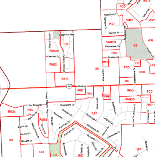
Figure 1 shows the residential zoning in the area, both existing and pending. The increase in density is indicated by the higher letter in the alphabet and the corresponding darker color.
![]() The
predominate residential zoning in the area at this time is the RS7 Zoning
District, which allows low density, single-dwelling residences. The red figures
in Figure 1 indicate approved Commercial development in the area, and
transitional medium density residential zoning has been approved adjacent to
these areas. The commercial area near the South Lawrence Trafficway is
surrounded by medium and higher densities zonings with the majority being RM12
Zoning and some RM12D (duplex only) districts and a cluster of RM24 Zoning
adjacent to the South Lawrence Trafficway, as recommended by the Northwest Plan.
The
predominate residential zoning in the area at this time is the RS7 Zoning
District, which allows low density, single-dwelling residences. The red figures
in Figure 1 indicate approved Commercial development in the area, and
transitional medium density residential zoning has been approved adjacent to
these areas. The commercial area near the South Lawrence Trafficway is
surrounded by medium and higher densities zonings with the majority being RM12
Zoning and some RM12D (duplex only) districts and a cluster of RM24 Zoning
adjacent to the South Lawrence Trafficway, as recommended by the Northwest Plan.
The Northwest Plan recommends ‘grading’ the density of development from
more intense along
A Rezoning application
[Z-10-25A-07] had previously been submitted for this property to rezone 27.90
acres from
The applicant reduced the size of the area being requested for rezoning to the RM15 District from 27.90 to 20.92 acres, a reduction of approximately 22%. An accompanying rezoning request has been submitted for the northern remainder of the property (6.98 acres) to be rezoned to the RM12 District.
Staff Finding -
Based on the compliance with the recommendations in the Northwest Plan and Horizon 2020 and the reduced area being requested for rezoning; Staff recommends approval of the rezoning request.
|
C*** C A A E D*** B B B A A A C C C E C C A |
||||||||||||||||||||||||||||||||||||||
|
Figure 1. Land uses in the area and variation in residential densities.
A Low density Single-dwelling Residential (RS7)
Low
density Multi-dwelling Residential (PD-The Links at
Medium Density Multi-dwelling limited to duplex development (RM12D)
C Medium Density Multi-dwelling. (RM12) C**** Associated Rezoning Request
D
E High Density Multi-dwelling (RM24) |


|
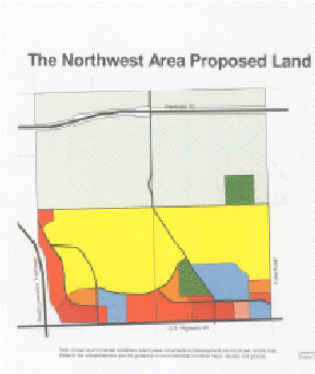
The Northwest Area Proposed Land Uses 28 29 21 20 |
||||||||||
|
Figure 2. Recommended land uses in the Northwest Area Plan and
Sections. Subject property is recommended for Office/multi-family mix. |


![]()