PLANNING COMMISSION REPORT
Regular Agenda – Public Hearing Item
PC Staff Report
ITEM NO. 6D :
Z-02-07D-08: A
request to rezone a tract of land approximately 5.669 acres from
|
STAFF RECOMMENDATION: Staff recommends denial of the rezoning
request for 5.669 acres from |
Applicant’s reason for request:
“This land is currently zoned
KEY POINTS
· This rezoning request is part of a development proposal for 1 lot, 24.21 acres, of multi-dwelling residential development; 2 lots, 7.23 acres of commercial development; and 3 lots, 5.669 acres of commercial-office development.
· The property is currently unplatted and a Preliminary Plat [PP-10-09-07] was submitted concurrently with this rezoning request.
GOLDEN FACTORS TO CONSIDER
CHARACTER OF THE AREA
·
The area is primarily undeveloped, but is in
transition as development proposals have been submitted for the areas at the
nearest intersections to the east and west and have been approved (preliminary
approval for the development to the west, final approval for the development to
the east).
CONFORMANCE WITH HORIZON 2020
§
The proposed rezoning request from
ASSOCIATED CASES/OTHER ACTION REQUIRED
·
·
·
·
City
Commission acceptance of easements and rights-of-way on the Preliminary Plat.
·
Planning
Director approval of the Final Plat.
·
Submittal
of Public Improvement Plans to Utilities and Public Works Departments.
·
Recording
of the Final Plat with the
·
Submittal
and administrative review of site plans for multi-family and commercial developments.
PUBLIC COMMENT RECEIVED PRIOR TO PRINTING
· No public comment has been received prior to printing this Staff Report.
GENERAL INFORMATION
|
Current Zoning and Land Use: |
|
|
Surrounding Zoning and Land Use: |
To the west: RS10 (Single-dwelling Residential)
District; a church; and GPI (General Public and Institutional
Use) District; a site plan for a City water tower has been approved. To the east: To the north: To the south: PRD (Planned Residential Development)
District; Multi-Dwelling development is currently under construction RS7 (Single-dwelling Residential
Development) District; undeveloped property which was platted as the Seventh
Day Adventist Church Addition. |
I. CONFORMANCE WITH THE
COMPREHENSIVE PLAN
Applicant’s Response:
“Horizon 2020, defines ‘office’ as ‘a
commercial area in which office and service uses predominate.’ (page 7-2) CO
zoning would allow offices to occur while at the same time allowing commercial
service uses for the offices and the surrounding neighborhoods.
This plan also complies with Horizon 2020
where it states, ‘Site access [should be] provided from arterial, collector or
access/frontage streets and traffic directed away from surrounding residential
areas.’ (age 7-11) This request conforms because it is located at the corners
of 6th (arterial) and Stoneridge (collector) and 6th and
The following statements are
recommendations from Horizon 2020
regarding Commercial Development and
New Commercial Areas
All new commercial and office development shall occur in accordance with the plan recommendations. New commercial, retail and related uses shall be developed as a node with shared parking areas, and common access drives.
Nodes shall be positioned and oriented to the primary street intersections where they are located, avoiding a ‘strip’ pattern as a result of extension of commercial uses along the streets from where the node originated.
Commercial nodes include other important community services and facilities, such as satellite post offices, police, fire and emergency services, religious facilities, community centers and other services and institutions. Inclusion of these uses assists the integration of the commercial area into the overall neighborhood, serving multiple communities and service needs in a single location, and creating physically distinctive use areas apart from traditional commercial areas. (page 6-20)
The uses which are listed as related
commercial uses for nodal development are uses which are permitted within the
CO District. The Comprehensive Plan recommends locating these uses within the
nodal development and discourages the strip development pattern being proposed.
Policy 2.5: Office, Research
and Semi-Public Development as Transitional Use
Encourage
using low-intensity office, research and semi-public development as a
transition between commercial development and low-density residential
neighborhood.
Commercial office uses are recommended for inclusion within commercial
nodal developments. Low-intensive offices are recommended as transitions
between commercial development and low-density residential neighborhoods. The
proposed office development would not serve as a transition, being located
between two medium-density residential neighborhoods on each side of
Policy 2.5 A(3) (Transitional Office
development shall include…)Site access provided from arterial, collector or
access streets, with traffic directed away from surrounding residential areas.
The proposed office development
proposes to take access from
Policy 3.4
Criteria for Neighborhood Commercial Centers(g), Locate office, public,
semi-public, parks and recreation or medium- and higher-density residential
developments on remaining corners of intersection to avoid excessive
concentrations of commercial traffic and unnecessary duplication of commercial
services. (page 6-32).
Office uses are recommended for location on
the other corners of a nodal development. In this situation office uses
extended linearly between two proposed nodal developments, creating a linear
commercial/commercial-office development pattern.
Staff Finding -- The proposed rezoning request is not in
compliance with Horizon 2020 policies
and recommendations for the following reasons:
§ the proposed development is designed as a linear strip development rather as a nodal development;
§ office uses are not proposed on the remaining corners of the nodal development or within the nodal development but are planned to extend between one proposed commercial node and another, creating a linear commercial/commercial-office development; and
§
commercial-office uses are being proposed as
transitional uses in an area where transition is not needed. (The proposed
commercial-office uses are located between medium-density multi-dwelling, residential
on the north side of
II.
ZONING
AND USE OF NEARBY PROPERTY, INCLUDING OVERLAY ZONING
Property adjacent to the subject property on the east, west and north are part of this development proposal. The property to the east and west has a CN2 Zoning request and the property to the north has multi-dwelling rezoning requests to the RM12 and RM15 Districts which are also being considered at the April Planning Commission meeting.
Property to the west of the property
within this development proposal is zoned GPI, for a City water tower; and
RS10, with a church. Property to the north had a development proposal for
single family and duplex residences and zonings of RS7 and RM12D approved. The
plat, Loges Addition, expired; therefore the zoning remains
Staff Finding -- The surrounding properties are zoned for residential purposes or have not yet been rezoned for urban development. The immediate area is mostly undeveloped with the exception of the St. Margaret’s Episcopal Church to the west and the Aberdeen Development, a medium density residential development which is under construction to the south. Construction of a City water tower is pending to the west. Commercial developments are proposed to the west and east.
III. CHARACTER OF THE NEIGHBORHOOD
Applicant’s response:
“The subject area is presently undeveloped or only partially developed.
The proposed CO zoning is surrounded by proposed CN2 to the west, proposed RM15
to the north, proposed CN2 to the east, and PRD and RS7 zoning to the south.
CO zoning will allow neighboring residents convenient pedestrian access
to offices and service uses, further benefited by numbers existing and/or
proposed sidewalks and recreation paths in and around the subject area.”
The area contains W 6th Street/Highway 40, which is designated as a principal arterial on the Major Thoroughfares Map; K-10 Bypass, which is designated as a freeway on the Major Thoroughfares Map; Queens Road, which is designated as a major collector on the Major Thoroughfares Map; and Wakarusa Drive, which is designated as a principal arterial on the Major Thoroughfares Map. The area is largely undeveloped at this time, but there are several development proposals pending which have had rezonings and Preliminary Development Plans approved. Figure 1 illustrates the location of existing and proposed commercial development in the area.
The immediate area contains
primarily residentially zoned property, or property which has not yet been rezoned
to an urban zoning district. The subject property is located between two
commercial nodes at the intersections of W 6th St and the K-10 Bypass
and W 6th St and Wakarusa Dr. Preliminary Development Plans for a
Staff Finding -- The subject property is located in a high traffic area along a principal arterial,
IV. PLANS FOR THE AREA OR NEIGHBORHOOD, AS REFLECTED IN ADOPTED AREA AND/OR
SECTOR PLANS INCLUDING THE PROPERTY OR ADJOINING PROPERTY
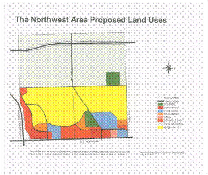
The Northwest Plan recommends a multi-family/office mixed development in this area on the future land use map (Figure 2).
Staff Finding -- The proposal is for commercial-office use in this
area, not for an office/multi-family mixed development as recommended in the Northwest Plan and therefore it is not compliant with plans which
have been adopted for the area.
V. SUITABILITY OF SUBJECT PROPERTY FOR THE USES TO WHICH IT HAS BEEN
RESTRICTED UNDER THE EXISTING ZONING REGULATIONS
Applicant’s Response:
“The existing
The
Staff Finding -- The
property as zoned would allow for only crop agriculture. Given the proximity to
Highway 40/W 6th Street and the K-10 Bypass, and the submittal of a
development proposal the zoning of
VI. LENGTH OF TIME SUBJECT PROPERTY HAS REMAINED VACANT AS ZONED
Applicant’s Response:
“The
property has remained vacant with the
Staff Finding – The property has never been developed but has been used for agricultural purposes.
VII. EXTENT TO WHICH APPROVING THE REZONING WILL DETRIMENTALLY AFFECT
NEARBY PROPERTIES
Applicant’s response:
“Because adequately designed perimeter
streets will separate the subject land from nearby properties, and because existing
and/or proposed pedestrian paths will allow convenient access, surrounding
properties will not be adversely affected by approving the CN2 zoning for this
site.”
The rezoning request would permit
commercial/office development in this area along
The Comprehensive Plan does not
recommend commercial office uses along
Staff Finding – The development could detrimentally impact nearby
properties through an increase in traffic generated from the proposed use and
the uses which are anticipated based on recommendations in Horizon 2020.
VIII. THE GAIN, IF ANY, TO THE PUBLIC HEALTH, SAFETY AND WELFARE DUE TO
DENIAL OF THE APPLICATION, AS COMPARED TO THE HARDSHIP IMPOSED UPON THE
LANDOWNER, IF ANY, AS A RESULT OF THE DENIAL OF THE APPLICATION
Applicant’s Response:
“The ability to provide necessary personal and neighborhood services to
a continually growing area populace (approx. 72 acres of multi-family and
approx. 41 acres of single-family with ¼ mile) will clearly benefit the public
health safety and welfare. Denial of the application would prohibit said
benefit”.
Evaluation of these criteria includes weighing the benefits to the public versus the benefits to the owner of the subject property. Benefits are measured based on the anticipated impacts of the rezoning request on the public health, safety and welfare. If the rezoning request were not approved, the land would remain undeveloped, pending a development proposal which is compliant with the recommendations of the Comprehensive Plan. Approval of the rezoning request may impact the public health, safety and welfare through the increased traffic volumes associated with strip commercial zonings.
Approval of commercial development in locations not anticipated by Horizon 2020 results in a departure from the long-range vision for the community and may result in strip commercial development. Departure from adopted plans reduces the ability of property owners to rely on plans when making property investments.
Staff Finding – If the
rezoning were not approved, the area could develop as recommended in Horizon 2020 and as anticipated by area
residents. The amount of traffic generated by the proposed commercial
development along
IX. PROFESSIONAL STAFF
RECOMMENDATION
Staff Review
An independent Retail Market Impact Analysis is required per Section 20-1107(a) of the Development Code for any proposed commercial development which could result in over 50,000 sq. ft. or more of additional floor area for retail businesses in the City. As the proposed rezoning and preliminary plat would create an area which could result in over 50,000 sq. ft. of retail floor area, a Retail Market Impact Analysis was required. The Retail Market Study that was submitted by the applicant has been reviewed by Staff. Staff is of the opinion that the Retail Market Study submitted satisfies the requirements of Section 20-1107 of the Development Code.
The location of the commercial and commercial office land use is not compliant with the recommendations in Horizon 2020 or the Northwest Plan. This area was planned as part of the Northwest Plan in 1997. The land use map (figure 2) shows that residential/office uses were recommended at this location. The text of the Northwest Area Plan provides the following statement regarding commercial development in this area:
“The plan reiterates the goal of Horizon
2020 to terminate the lineal (strip) commercial development along
![]() The
proposed rezoning does not comply with recommendations of Horizon 2020 or the Northwest Plan; therefore, Staff does
not support the rezoning request. Staff
would be supportive of a rezoning request that included a mix of multi-dwelling
residential and office, such as the RMO Zoning District.
The
proposed rezoning does not comply with recommendations of Horizon 2020 or the Northwest Plan; therefore, Staff does
not support the rezoning request. Staff
would be supportive of a rezoning request that included a mix of multi-dwelling
residential and office, such as the RMO Zoning District.
The CO District permits some commercial uses along with office uses, and does not permit residential uses, with the exception of group homes for 11 individuals or more. Uses that are permitted in the CO District in addition to office are listed below:
- Community, medical and recreational and facilities such as schools, postal & parcel service, public safety, and funeral & internment,
- Health care offices and extended care facilities,
- places of religious assembly,
- Veterinarian office or animal sales/grooming
- Quality restaurant and fast order food, without drive-in
- Various retail uses including business support, communications, food and beverage, mixed Media store, general retail sales,
- Research industrial facilities,
- Communications service establishment
Staff Finding
The proposed rezoning to the CO District is not compliant with the recommendations in the Comprehensive Plan or the Northwest Plan; therefore Staff recommends denial of the rezoning request. Staff would support a rezoning request that is in conformance with the recommendations in the area and comprehensive plan for a mixed office/multi-dwelling residential development, such as the RMO (Multi-Dwelling Residential-Office) District.
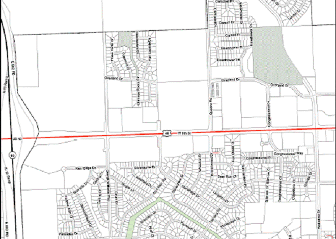
Bauer Farms PCD Westgate PCD CN* PCD Wal-Mart PCD Northgate PCD Mercato PCD![]()
![]()


![]()
Figure 1. General
locations of commercial development in the area. Mercato, Northgate and
Wal-Mart Preliminary Development Plans have been approved, and Colonial Northeast
(CN*) is an established commercial
center. Subject property outlined in BLUE.
County road Major street City park Commercial Institutional Multi-family Office Office/m.f. mix Rural Residential Single-family X Figure 2.
Land Use map from the Northwest Area
Plan. Subject property (shown with an X) is recommended for development
as Office / multi-family mix.