EXHIBIT A
MAP OF
REDEVELOPMENT DISTRICT
AND PROJECT
AREA
(Published in
RESOLUTION NO. 6757
A
RESOLUTION OF THE GOVERNING BODY OF THE CITY OF LAWRENCE,
KANSAS ESTABLISHING THE DATE AND TIME OF A PUBLIC HEARING REGARDING THE
ADOPTION OF A REDEVELOPMENT PROJECT PLAN PURSUANT TO K.S.A. 12-1770 ET SEQ.
_________________________________________________________________________
WHEREAS, the
City of Lawrence, Kansas (the “City”), by the adoption of
Ordinance No. 8234 February 19, 2008, created a redevelopment district (the
“Redevelopment District”) consisting of one redevelopment project area (the “Oread Project
Area”), all pursuant to K.S.A. 12-1770 et seq. as amended (the “Act”); and
WHEREAS, the City is considering the
adoption of a redevelopment project plan entitled “The Oread Redevelopment Tax
Increment Financing Project Redevelopment Project Plan” and dated February ___, 2008 (the “Project Plan”) which provides for the redevelopment of the Oread
Project Area within the Redevelopment District; and
WHEREAS, on February 25, 2008 the Planning Commission of the City made a finding that the Project Plan is consistent with the intent of the City’s comprehensive plan for the development of the City; and
WHEREAS,
a copy of the Project Plan has been delivered by the City to the Board of
County Commissioners of
NOW, THEREFORE, BE IT RESOLVED BY
THE GOVERNING BODY OF THE CITY OF
Section 1. Notice
is hereby given that a public hearing will be held by the City to consider the
adoption of the Project Plan on April 1, 2008
in the City Commission Chambers located in City Hall at
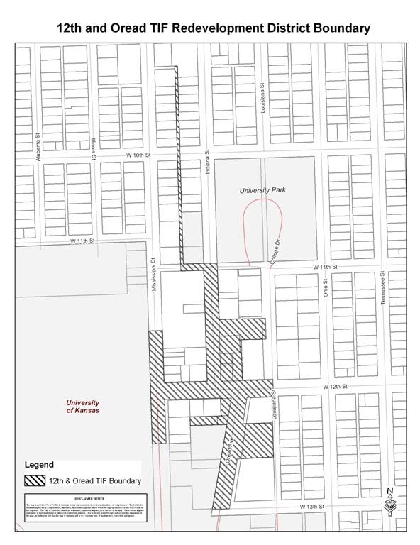
Section 2. The boundaries of the Redevelopment District are shown on Exhibit A attached hereto and incorporated herein. The Project Plan is for the redevelopment of the Oread Project Area, which is shown on Exhibit A and legally described on Exhibit B hereto.
Section 3. Copies of the Project Plan, including a summary of the
feasibility study, relocation assistance plan and financial guarantees of the
developer, and a description and map of the Redevelopment District and the Oread
Project Area are available for inspection during regular office hours in the
office of the City Clerk in City Hall, at
Section 4. The City Clerk shall send a copy of this Resolution via certified mail, return receipt requested, to the Board of County Commissioners of Douglas County, Kansas, to the Board of Education of Unified School District No. 497, and to each owner and occupant of land within the Oread Project Area. Such copies shall be sent not more than 10 days following the date of adoption of this Resolution. The City Clerk shall also cause this Resolution and all exhibits hereto, to be published once in the official city newspaper not less than one week nor more than two weeks preceding the date fixed for the public hearing.
ADOPTED by the Governing Body of the City of
[SEAL]
_______________________________________
Sue Hack, Mayor
Attest:
____________________________________
Frank S. Reeb, City Clerk
Approved as to form and legality:
Toni Ramirez Wheeler, Director of Legal
Services
MAP OF
REDEVELOPMENT DISTRICT
AND PROJECT
AREA
EXHIBIT B
LEGAL
DESCRIPTION OF REDEVELOPMENT DISTRICT
Beginning at the Intersection of
the Centerline of Louisiana Street and the South Right-of-way line of West 12th
Street (Hancock Street) in the Southeast Quarter (SE ¼) of Section 36, Township
12 South, Range 19 East of the Sixth Principal Meridian in the City of
Lawrence, Douglas County, Kansas; thence West on the South Right-of-way line of
West 12th Street (Hancock
Street) extended to the Northeast Corner of Lot 1, Block 3, Oread Addition;
thence continuing West on the South Right-of-way line of said West 12th
Street (Hancock Street) to the Northwest corner of Lot 1, Block 3, Oread
Addition; thence in a Southwesterly direction on the East Right-of-way line of
Oread Avenue to the Northwest corner of the South One-half (S ½) of Lot 2,
Block 3, Oread Addition; thence East on the North line of the South one-half (S
½) of said Lot 2 to the Northeast corner of the South One-half (S ½) of said
Lot 2; thence South on the East line of said Block 3 Oread Addition to the Southeast
corner of the North One-half (N ½) of Lot 4, Block 3 of Oread Addition; thence
West on the South line of the North One-half (N ½) of Lot 4, Block 3 of Oread
Addition to the Southwest corner of the North One-half (N ½) of Lot 4, Block 3
of Oread Addition and the East Right-of-way line of Oread Avenue; thence in a
Southwesterly direction on the East Right-of-way line of Oread Avenue to the
Southwest corner of Lot 6, of Oread Heights Addition, A Subdivision of Block 3,
Oread Addition; thence continuing in a Southwesterly direction on the East
Right-of-way line of Oread Avenue extended to the Centerline of 13th
Street (Lee Street); thence West on the Centerline of said 13th
Street (Lee Street) to the West Right-of-way line of Oread Avenue; thence in a
Northeasterly direction on the West Right-of-way line of Oread Avenue to the
Southeast corner of the North One-half (N ½) of Lot 2, Block 8 of Oread
Addition; thence West on the South line of the North One-half (N ½) of Lot 2,
Block 8 of Oread Addition to the Southwest corner of North One-half (N ½) of
Lot 2, Block 8 of Oread Addition; thence North on the West line of the North One-half (N ½) of Lot 2, Block 8 of
Oread Addition to the Southwest corner of Lot 1, Block 8 of Oread Addition;
thence East on the South line of Lot 1, Block 8 of Oread Addition 180 feet;
thence North parallel with the West line of Lot 1, Block 8 of Oread Addition to
the South Right-of-way line of 12th Street (Hancock Street); thence
West on the South Right-of-way line of 12th Street (Hancock Street)
to the Northwest corner of Lot 12, Block 8 of Oread Addition and the East
Right-of-way line of Mississippi Street; thence South on the East Right-of-way
line of Mississippi Street to the Southwest corner of the North One-half (N ½)
of Lot 10, Block 8 of Oread Addition; thence West on the South line of the
North One-half (N ½) of Lot 10, Block 8 of Oread Addition projected West, to
the West Right-of-way line of Mississippi Street; thence North on the West
Right-of-way line of Mississippi Street to the intersection of the North line
of Lot 9, Block 9 of Oread Addition projected West; thence East on the North
line of Lot 9, Block 9 of Oread Addition extended, to the Northwest corner of
Lot 9, Block 9 of Oread Addition and the East Right-of-way line of Mississippi
Street; thence South on the East Right-of-way line of Mississippi Street to the
Southwest corner of Lot 7, Block 9 Oread Addition, and the North Right-of-way
line of 12th Street (Hancock Street); thence East on the North
Right-of-way line of 12th Street (Hancock Street) to the Southeast
corner of Lot 6, Block 9 of Oread Addition and the West Right-of-way line of
Indiana Street; thence North on the West Right-of-way line of Indiana Street to
the Northeast corner of Lot 1, Block 9 of Oread Addition and the Southeast
corner of Lot 3, Block 14, Lane’s Second Addition; thence continuing North on
the West Right-of-way line of Indiana Street to the Northeast corner of Lot 1,
Block 14, Lane’s Second Addition and the South Right-of-way line of 11th
Street (Quincy Street); thence West on the South Right-of-way line of 11th
Street (Quincy Street) to the intersection of the East line of Lots 13 thru 24,
Block 13, Lane’s Second Addition projected South; thence North on the East line
of Lots 13 thru 24, Block 13, Lane’s Second Addition extended, to the Southeast
corner of Lot 13, Block 13, Lane’s Second Addition and the North Right-of-way
line of 11th Street (Quincy Street); thence North on the East line
of Lots 13 thru 24, Block 13, Lane’s Second Addition to the Northeast corner of
Lot 24, Block 13, Lane’s Second Addition and the South Right-of-way line of 10th
Street (Berkeley Street); thence continuing North on the East line of Lots 13
thru 24, Block 13, Lane’s Second Addition projected North to the Southeast
corner of Lot 15, Block 11 Lane’s Second Addition; thence North on the East
line of Lots 15 thru 23, Block 11, Lane’s Second Addition to the Northeast
corner of Lot 23, Block 11, Lane’s Second Addition; thence North on the East
line of Lots 15 thru 23, Block 11, Lane’s Second Addition projected North, to
the South line of Lot 3, Block 11, Lane’s Second Addition; thence East on the
South line of Lot 3, Block 11, Lane’s Second Addition to the intersection of
the West line of Lots 6 thru 14, Block
11, Lane’s Second Addition projected North; thence South on the West line of
Lots 6 thru 14, Block 11, Lane’s Second Addition extended, to the Northwest
corner of Lot 6, Block 11, Lane’s Second Addition; thence South on the West
line of Lots 6 thru 14, Block 11, Lane’s Second Addition to the Southwest
corner of Lot 14, Block 11, Lane’s Second Addition and the North Right-of-way
line of 10th Street (Berkeley Street); thence South on the West line
of Lots 6 thru 14, Block 11, Lane’s Second Addition extended, to the Northwest
corner of Lot 1, Block 13, Lane’s Second Addition, and the South Right-of-way
line of 10th Street (Berkeley Street); thence South on the West line
of Lots 1 thru 12, Block 13, Lane’s Second Addition to the Southwest corner of
Lot 12, Block 13 Lane’s Second Addition and the North Right-of-way line of 11th
Street (Quincy Street); thence East on the South line of Lot 12, Block 13,
Lane’s Second Addition and the North Right-of-way line of 11th
Street (Quincy Street) to the Southeast corner of Lot 12, Block 13 Lane’s
Second Addition; thence continuing East on the North Right-of-way line of 11th
Street (Quincy Street) extended to the Southwest corner of University Park
(Northeast corner of 11th Street (Quincy Street) and Indiana
Street); thence South on the East Right-of-way line of Indiana Street projected
North from Block 15, Lane’s Second Addition to the Northwest corner of Lot 6,
Block 15, Lane’s Second Addition; thence South on the
East Right-of-way line of Indiana Street to the Southwest corner of Lot 4,
Block 15, Lane’s Second Addition and the Northwest corner of Lot 12, Block 2,
Oread Addition; thence continuing South on the East Right-of-way line of
Indiana Street to the Northwest corner of the South 55 feet of Lot 10, Block 2,
Oread Addition; thence East on the North line of the South 55 feet of Lot 10,
Block 2, Oread Addition to the Northeast corner of the South 55 feet of Lot 10,
Block 2, Oread Addition and the Northwest corner of the South 55 feet of Lot 3,
Block 2, Oread Addition; thence continuing East on the North line of the South
55 feet of Lot 3, Block 2, Oread Addition to the Northeast corner of the South
55 feet of Lot 3, Block 2, Oread Addition; thence South on the East line of
Lots 3, and 4, Block 2, Oread Addition to the Southeast corner of the North 65
feet of Lot 4, Block 2, Oread Addition; thence West on the South line of the
North 65 feet of Lot 4, Block 2, Oread Addition to the Southwest corner of the
North 65 feet of Lot 4, Block 2 Oread Addition and the East line of Lots 9, 8,
and 7, Block 2, Oread Addition; thence South on the East line of Lots 9, 8 and
7, Block 2, Oread Addition to the Southeast corner of Lot 7, Block 2, Oread
Addition and the North Right-of-way line of 12th Street (Hancock
Street); thence East on the North Right-of-way line of 12th Street
(Hancock Street) to the Southeast corner of Lot 6, Block 2, Oread Addition;
thence continuing East on the North Right-of-way line of 12th Street
(Hancock Street) extended to the Centerline of Louisiana Street; thence South on
the Centerline of Louisiana Street to the Point of Beginning; Containing 8.51
Acres more or less all in the City of Lawrence, Douglas County, Kansas.
EXCERPT OF MINUTES OF A MEETING
OF THE GOVERNING BODY OF
HELD ON FEBRUARY 26, 2008
The
governing body met in regular session at the usual meeting place in the City,
at 6:35 p.m., the following members being present and participating, to-wit:
Absent:
The
Mayor declared that a quorum was present
and called the meeting to order.
*
* * * * * * * * * * * * *
(Other
Proceedings)
The
matter of calling a public hearing to establish the date and time of a public
hearing regarding the adoption of a redevelopment project plan within the City
came on for consideration and was discussed.
Commissioner ________________ presented and
moved the adoption of a Resolution entitled:
A RESOLUTION OF THE GOVERNING BODY OF THE CITY
OF LAWRENCE, KANSAS ESTABLISHING THE DATE
AND TIME OF A PUBLIC HEARING REGARDING THE ADOPTION OF A REDEVELOPMENT PROJECT
PLAN PURSUANT TO K.S.A. 12-1770 ET SEQ.
Commissioner ________________ seconded the
motion to adopt the Resolution.
Thereupon, the Resolution was read and considered, and, the question
being put to a roll call vote, the vote thereon was as follows:
Aye:
________________________________________________________________________.
Nay:
________________________________________________________________________.
The
Mayor declared the Resolution duly
adopted; the Clerk designating the same Resolution No. ______.
*
* * * * * * * * * * * * *
(Other
Proceedings)
[BALANCE
OF THIS PAGE INTENTIONALLY LEFT BLANK]
* * * * * * * * * * * *
* *
CERTIFICATE
I hereby certify that the foregoing
Excerpt of Minutes is a true and correct excerpt of the proceedings of the
governing body of the City of Lawrence, Kansas, held on the date stated therein, and
that the official minutes of such proceedings are on file in my office.
(SEAL)
Clerk
[CITY LETTERHEAD]
**[MUST BE SENT WITHIN 10 DAYS FOLLOWING DATE
RESOLUTION ADOPTED. SEND TO COUNTY, EACH
SCHOOL DISTRICT AND EACH PROPERTY OWNER AND OCCUPANT WITHIN THE PROPOSED TIF
DISTRICT.]**
VIA CERTIFIED MAIL, RETURN RECEIPT REQUESTED
DATE: February ___, 2008
TO: Board of County Commissioners of Douglas County, Kansas
Board of Education of
Unified
All property owners and users in the Oread Project Area
FROM:
Frank Reeb, City Clerk
RE: April 1, 2008 Public Hearing on Project Plan for Oread Project Area in the 12th & Oread Redevelopment District
On April 1, 2008, the City of Lawrence will hold a public hearing on the Project Plan for the Oread Project Area in the 12th & Oread Redevelopment District. Enclosed please find a notice of the public hearing.
Copies of the Project Plan are available for
inspection during regular office hours in the office of the City Clerk in City
Hall, at
CERTIFICATE OF
MAILING
I, Frank Reeb, City Clerk for the City of Lawrence, Kansas (the “City”), do hereby certify that on February 28, 2008, the City Clerk’s office a copy of Resolution No. ___________ calling a public hearing on the Project Plan for Oread Project Area in the 12th & Oread Redevelopment District, via certified mail to the Douglas County, Kansas Board of County Commissioners, the U.S.D. 497 Board of Education and via certified mail, return receipt requested, to each owner and occupant of land within the proposed redevelopment project area described in the resolution. Copies of the certified mail receipts are attached hereto.
Dated: _________________, 2008
_____________________________________
City Clerk