|
PLANNING
COMMISSION REPORT Regular Agenda
– Public Hearing Item |
PC Staff
Report
ITEM
NO. 2: RM24 TO RSO; 4.41 ACRES;
NORTH OF
Z-10-69-05: A request to rezone two tracts of land
totaling approximately 4.41 acres from RM24 (Multi-Dwelling Residential) to RSO
(Single-Dwelling Residential-Office) [Note: the request originally rezoned the
tracts from RM-2 (Multiple-Family Residential) District to RO-1B
(Residence-Office) District]. The property is generally described as being
located north of
|
STAFF
RECOMMENDATION: Staff
recommends approval of rezoning approximately 4.41 acres from the RM24 District
to the RSO District and forwarding it to the City Commission with a
recommendation for approval based on the findings of fact found in the body
of the staff report. |
|
|
Reasons for Request: |
To follow the recommendations of the HOP District Plan to zone property to
the current use based on the neighborhood association task force study and
recommendations. |
|
KEY
POINTS
|
|
GOLDEN
FACTORS TO CONSIDER CHARACTER OF THE AREA
CONFORMANCE WITH HORIZON 2020
|
|
ASSOCIATED CASES/OTHER ACTION REQUIRED All zoning case related to
the HOP District Plan Z-09-53-05 C-5 to RO-1A: 0.53 acre; southeast corner of Z-09-54-05 C-5 to RO-1; 0.34 acre; north of Z-09-55-05 RM-1 to RO-1;
0.35 acre; north of Z-09-56-05 RO-2 to O-1;
1.52 acres; south of W. 6th Street between Maine and Alabama Streets [1015 W.
6th Street] HOP Plan –published on 1/9/06 Z-09-57-05 RM-1 to RS-2;
2.11 acres; south of Z-10-67-05 RM-1 to RS-2; 2.15 acres north of Z-10-67-05A RM-2 to RS-2; 1.22 acres 1508, 1500 W. 5th Street; Z-10-68-05 C-5 to RM-2;
3.13 acres east of Z-10-70-05 RM-2 to RO-1A;
1.60 acres east of Z-10-71-05 RM-2 to RO-2;
2.27 acres north of Z-10-72-05 RM-3 to RM-2;
2.19 acres south of W. 7th Street, east of Wisconsin Street (1515
W. 7th Street) – MJL PC Denied 7-3; initiated RM-1 (approved
10-0) [see Z-12-81-05]. Z-10-73-05 RM-3 to RS-2;
.70 acres of a parcel north of the intersection of Z-10-74-05 C-5 to RO-1;
.84 acres at the northeast corner of Z-10-75-05A C-5 to RO-1A;
0.146 acre at the northwest corner of Z-10-75-05B C-5 to RO-1A;
2.02 acres at the northwest corner of Z-10-76-05 C-5 to RM-3;
3.0 acres at the southeast corner of Z-10-77-05 C-5 to RO-2;
.51 acres at the southwest corner of |
|
PUBLIC
COMMENT RECEIVED PRIOR TO PRINTING
|
|
GENERAL INFORMATION |
|
|
Current Zoning and Land Use: |
RM24 (Multi-Dwelling Residential) District;
south half of |
|
Surrounding Zoning and Land Use: |
CS (Commercial Strip) District to the
north; north half of the Eagles Club property, discount store, auto rental,
auto detail shop, motel. RS7 (Single-Dwelling Residential)
District to the south; Single-family homes. RM24 District to the west; apartment
complex RMO (Multi-Dwelling Residential-Office) District
to the east; duplex, 4-plex |
I. ZONING
AND LAND USES OF SURROUNDING PROPERTIES
The properties directly to the south are zoned RS7 and are developed with
large lot, single-family residential homes.
The properties to the north are zoned CS and are developed with
commercial uses (discount store, rental car, auto detaining, and a motel). The property to the west of the subject
properties is zoned RM24 and is developed with an apartment complex. The properties to the east of the subject
properties are zoned RMO and developed with a duplex and a 4-plex.
Staff Finding – The request is to rezone approximately 4.41 acres from the RM24 District
to the RSO District. The subject properties currently include the Eagles Club
building and a vacant lot. The areas surrounding the subject properties are
zoned CS, RM24, and RS7 Districts.
As part of the HOP District Plan recommendations, the
neighborhoods were to set up a task force to study the relationship of land use
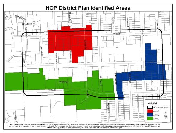
and zoning of the areas identified in the plan (see Map 1), which are included
in the particular neighborhood association, and located within the study area
of the HOP District Plan. The plan recommended that the zoning be
updated to reflect the current use. The
Hillcrest Neighborhood Association studied the area in green in the Map 1 for
consistency of land use with zoning. As
a result of this study and meeting with property owners, the task force
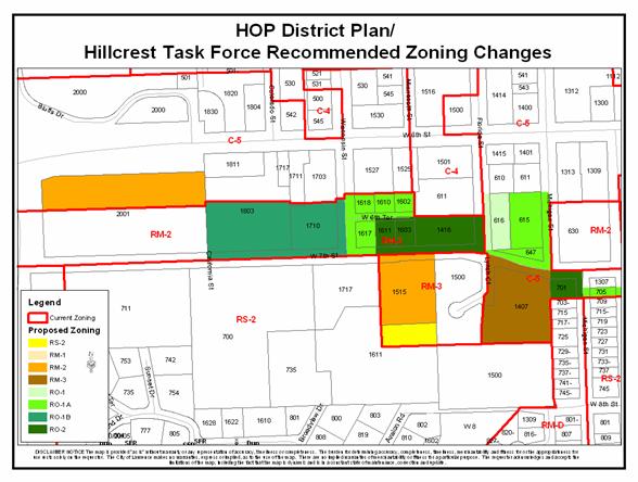
identified properties or portions of properties and recommended zonings as
shown on Map 2. The task force requested
the City Commission initiate the 10 rezonings, which contained 18 properties,
as part of the implementation of the HOP
District Plan. Today, 14 of the 18
properties have been rezoned.
Map 1
Map 2
II. CHARACTER OF THE AREA
Staff Finding – The area is characterized
by a variety of densities of residential and commercial uses. The parcels
directly surrounding the subject properties are zoned for commercial and
residential uses. The subject properties act as a transitional area between the
single-family residential uses along
III. SUITABILITY OF SUBJECT PROPERTY FOR THE
USES TO WHICH IT HAS BEEN RESTRICTED
The subject properties are currently zoned for multiple-family
residential use. According to the Land
Development Code, the RM24 District requires a minimum lot area of 6,000 square feet and allows
up to 24 dwelling units per acre for residential development. The general
purpose of the RM districts are intended “…to create, maintain and promote
higher density housing opportunities in areas with good transportation access”.
The request is to
rezone the subject properties to the RSO District, which requires a minimum lot
area of 5,000 square feet and allows up to 15 dwelling units per acre for residential
development and for the development of professional office uses. The primary purpose
of the RSO district is “…to accommodate low to medium intensity administrative
and professional offices that are compatible with the character of low and
medium-density residential neighborhoods. The District is also intended to be used as
a transitional Zoning District between higher intensity commercial areas and
residential neighborhoods.”
Staff Finding – Currently the western most of the two properties, the Eagles Club, is
split between the CS District and the RM24 District zonings. The north half of the property is zoned CS
District and the south half, which contains the structure, is zoned RM24
District. The vacant property on the east
side of this request is zoned entirely RM24 District. The RSO District zoning would allow development
and redevelopment of various community facility uses, residential development up
to 15 units per acre, and/or professional office uses, subject to any
additional applicable regulation in the Land
Development Code. The RSO District zoning
is more suitable based on its purpose statement than the RM24 zoning is for these
properties which form a transition between the
IV. LENGTH OF TIME SUBJECT PROPERTY HAS
REMAINED VACANT AS ZONED
Staff Finding - The north half of
the Eagles Club property was zoned C-5 District and the south half of the
Eagles Club property and the vacant property (
V. EXTENT TO WHICH REMOVAL OF RESTRICTIONS
WILL DETRIMENTALLY AFFECT NEARBY PROPERTY
Staff Finding –The RSO District
is more restrictive as far as the residential density permitted but additionally
permits professional office uses. The
proposed zoning would be an appropriate transition between the commercial development
along
VI.
RELATIVE GAIN TO THE PUBLIC HEALTH, SAFETY AND
WELFARE BY THE DESTRUCTION OF THE VALUE OF THE PETITIONER’S PROPERTY AS
COMPARED TO THE HARDSHIP IMPOSED UPON THE INDIVIDUAL LANDOWNERS
Evaluation of
this criterion includes weighing the benefits to the public versus the benefit
of the owners of the subject property. Benefits are measured based on
anticipated impacts of the rezoning request on the public health, safety, and
welfare.
Staff Finding – If the property
retains its RM24 District designation, there is the potential to redevelop with
a residential density of 24 units per acre in the form of multi-dwelling structures. The
proposed RSO District zoning will allow a maximum density of 15 dwelling
units per acre in the form of single-family, duplex, and attached dwellings
with the addition of administrative and professional office uses. The residential and office uses could be
combined into one structure providing a variety of uses on one lot. The proposed rezoning would allow the
creation of a reasonable transition of land uses that is not currently assured
by the existing zoning. The proposed
zoning does decrease the potential number of units but increases the permitted
uses.
Approval of the rezoning request will protect the public health, safety,
and welfare by ensuring that high-density residential uses and the associated traffic
will not filter into the neighborhood. The
low to medium-density multiple-family residential and office uses will maintain
an appropriate transition between the commercial and lower-density residential
uses and protect the abutting properties.
VII. CONFORMANCE WITH THE COMPREHENSIVE PLAN
The subject
property is located along the north side of
RESIDENTIAL LAND USE GOALS AND POLICIES
Low-Density Residential Land Use
GOAL 6: Compatible Transition from Low-Density
Residential Development to
Policy
6.2: Higher-Density Residential
development as Transitional Use (5- 20)
Medium-and Higher-Density Residential Land Use
GOAL 3:
Compatible Transition from Medium and Higher Density Residential Development
to both More Intensive and Less Intensive Land Uses (Page 5-25)
Policy
3.1: Use Appropriate Transitional
Methods (Page 5-25)
Policy
3.2: Medium-Density Residential
Development as Transitional Use (Page 5-26)
GOAL 2: Compatible
Transition from Commercial Development to Less Intensive Uses (Page 6-27)
Policy
2.5 Office, Research and Semi-Public Development as Transitional Use (Page 6-29)
Staff Finding – The rezoning conforms to several Horizon
2020 policies related to residential and commercial land uses and
transitions between more and less intensive land uses. The subject properties’
rezonings will allow for the development of appropriate transitions in the area
between the commercial uses along
STAFF REVIEW
The subject property is located on the
north side of
This rezoning request is the result of the
implementation of the HOP District Plan. The history on this issue dates back to 2004 when
the City Commission denied a site plan for apartments at
·
GOAL
1: Preserve and improve commercial urban
core and adjacent historical residential neighborhoods by encouraging
aesthetically appealing redevelopment through design standards.
-
Create
design guideline task force.
-
Establish
design guidelines (Commercial and/or Residential).
-
Create
overlay zone(s).
·
GOAL
2: Encourage redevelopment and support compatible mixed-use development.
-
Create
zoning task force.
-
Review
identified areas for land use and zoning.
-
Conduct
meetings with affected property owners (2-5).
-
Rezoning(s)
based on recommendations.
·
GOAL
3: Promote identification of the
district as a gateway to downtown and as a medical entryway for community medical
services.
-
Create
identification task force.
-
Contact
LHM representatives regarding signage.
-
Incorporate
streetscape items and pedestrian scale items into district
-
Promote
the district as a medical campus (Cooperation with the Chamber of Commerce).
After the approval of the plan, the neighborhood task forces and
planning staff worked together to begin the implementation of Goal 2. The task force from each neighborhood worked
to study the identified areas as shown in Map 1 and held property owner meetings.
In September 2005 the Old West Neighborhood task force requested initiation of
5 rezonings that included 16 properties.
In October 2005, both the Hillcrest and the Pinckney Neighborhood task
force requested initiation of rezonings.
Hillcrest requested 10 rezonings that included 16 properties or portions
of properties, and Pinckney requested 1 rezoning that included 7
properties. Total there were 16
rezonings initiated which included 39 properties or portions of
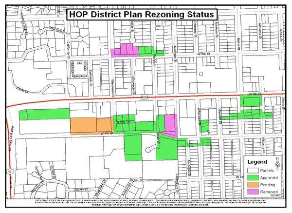
properties. Map 3 shows the status of
all of the initiated rezonings. There
are two of the rezonings that were split from the original request. The properties shown on Map 4 at the
northwest of the intersection of W. 7th and Michigan Streets (615,
639, 645, and 647 Michigan St.) were denied rezoning because it was felt that
the Land Development Code could offer
a retail/commercial mix district unavailable in the existing code at that time. These properties were to be revisited after
the adoption of the Land Development Code. The properties shown on Map 4 along
Map 3
Map 4
The subject properties
are the last of the original task force requests and the last step to complete Goal
2 of the recommendations. This request
was originally heard by the Planning Commission on