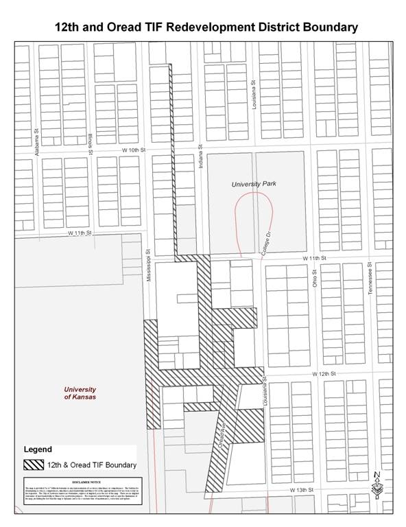
EXHIBIT A
MAP OF
REDEVELOPMENT DISTRICT
AND PROJECT
AREA
(Published in
ORDINANCE NO. 8234
AN ORDINANCE OF THE GOVERNING
BODY OF THE CITY OF LAWRENCE, KANSAS
MAKING FINDINGS AND ESTABLISHING A REDEVELOPMENT DISTRICT PURSUANT TO K.S.A.
12-1770 ET SEQ., AND AMENDMENTS THERETO.
WHEREAS, pursuant to the provisions of K.S.A. 12-1770 et seq., as amended (the “Act”), the City of Lawrence, Kansas (the “City”) is authorized to establish redevelopment districts within a defined area of the City which is found by the City to be a conservation area, and is therefore an “eligible area” as said term is defined in the Act; and
WHEREAS, the Governing Body adopted Resolution No. 6749 on January 8, 2008 calling for a public hearing considering the establishment of a redevelopment district to be held by the Governing Body on February 12, 2008; and
WHEREAS, notice of the public hearing was given as required by the Act; and
WHEREAS, the public hearing was held on February 12, 2008 and closed on the same day; and
NOW,
THEREFORE, BE IT ORDAINED BY THE GOVERNING BODY OF THE CITY OF
SECTION 1. The Governing Body hereby finds that the real property described in Exhibits A and B (the “Redevelopment District”) attached hereto is an eligible area for being designated as a redevelopment district pursuant to the Act because the real property is hereby found by the City to be a conservation area based on the determination by the City that:
(a) the Redevelopment District comprises less than 15% of the land area of the City;
(b) 50% or more of the structures in the Redevelopment District are at least 35 years old; and
(c) the Redevelopment District is not yet blighted, but may become blighted due to: (i) the existence of dilapidated and deteriorated structures, (ii) the presence of structures below minimum code standards and (iii) inadequate utilities and infrastructure.
SECTION 2. The Governing Body hereby finds that the conservation, development or redevelopment of the Redevelopment District is necessary to promote the general and economic welfare of the City.
SECTION 3. The Governing Body hereby establishes the Redevelopment District, which shall include One project area, all depicted on the map attached hereto as Exhibit A. The district plan is hereby approved, and consists of buildings and facilities to be constructed within the One project area, generally described as follows:
A multi-use structure consisting of
approximately 106 rooms and associated commercial spaces. These rooms include
approximately 92 hotel rooms and extended stay suites, and approximately 14
condominiums. The structure will include ancillary uses such as meeting and
conference rooms, banquet rooms, restaurant space, and bar space. Additional
commercial uses may consist of a bank, retail stores, and other similar
commercial uses allowed by the City of
SECTION 4. Severability.
If any section, clause, sentence, or phrase
of this ordinance is found to be unconstitutional or is otherwise held invalid
by any court of competent jurisdiction, it shall not affect the validity of any
remaining parts of this ordinance.
SECTION 5. This Ordinance shall take effect and be in force from and after its passage and publication as provided by law.
PASSED by the Governing Body this FEBRUARY 19, 2008.
SIGNED by the Mayor this FEBRUARY 19, 2008.
Sue Hack, Mayor
(SEAL)
Frank S. Reeb, City Clerk
APPROVED AS TO FORM AND LEGALITY:
Toni Ramirez Wheeler, Director of Legal
Services
EXHIBIT A
MAP OF
REDEVELOPMENT DISTRICT
AND PROJECT
AREA
EXHIBIT B
LEGAL
DESCRIPTION OF REDEVELOPMENT DISTRICT
Beginning at the Intersection of the Centerline of
Louisiana Street and the South Right-of-way line of West 12th Street
(Hancock Street) in the Southeast Quarter (SE ¼) of Section 36, Township 12
South, Range 19 East of the Sixth Principal Meridian in the City of Lawrence,
Douglas County, Kansas; thence West on the South Right-of-way line of West 12th Street (Hancock Street) extended to the
Northeast Corner of Lot 1, Block 3, Oread Addition; thence continuing West on
the South Right-of-way line of said West 12th Street (Hancock
Street) to the Northwest corner of Lot 1, Block 3, Oread Addition; thence in a
Southwesterly direction on the East Right-of-way line of Oread Avenue to the
Northwest corner of the South One-half (S ½) of Lot 2, Block 3, Oread Addition;
thence East on the North line of the South one-half (S ½) of said Lot 2 to the
Northeast corner of the South One-half (S ½) of said Lot 2; thence South on the
East line of said Block 3 Oread Addition to the Southeast corner of the North
One-half (N ½) of Lot 4, Block 3 of Oread Addition; thence West on the South
line of the North One-half (N ½) of Lot 4, Block 3 of Oread Addition to the
Southwest corner of the North One-half (N ½) of Lot 4, Block 3 of Oread
Addition and the East Right-of-way line of Oread Avenue; thence in a
Southwesterly direction on the East Right-of-way line of Oread Avenue to the
Southwest corner of Lot 6, of Oread Heights Addition, A Subdivision of Block 3,
Oread Addition; thence continuing in a Southwesterly direction on the East Right-of-way
line of Oread Avenue extended to the Centerline of 13th Street (Lee
Street); thence West on the Centerline of said 13th Street (Lee
Street) to the West Right-of-way line of Oread Avenue; thence in a
Northeasterly direction on the West Right-of-way line of Oread Avenue to the
Southeast corner of the North One-half (N ½) of Lot 2, Block 8 of Oread
Addition; thence West on the South line of the North One-half (N ½) of Lot 2,
Block 8 of Oread Addition to the Southwest corner of North One-half (N ½) of Lot
2, Block 8 of Oread Addition; thence North on the West line of the North One-half (N ½) of Lot 2, Block 8 of
Oread Addition to the Southwest corner of Lot 1, Block 8 of Oread Addition;
thence East on the South line of Lot 1, Block 8 of Oread Addition 180 feet;
thence North parallel with the West line of Lot 1, Block 8 of Oread Addition to
the South Right-of-way line of 12th Street (Hancock Street); thence
West on the South Right-of-way line of 12th Street (Hancock Street)
to the Northwest corner of Lot 12, Block 8 of Oread Addition and the East
Right-of-way line of Mississippi Street; thence South on the East Right-of-way
line of Mississippi Street to the Southwest corner of the North One-half (N ½)
of Lot 10, Block 8 of Oread Addition; thence West on the South line of the
North One-half (N ½) of Lot 10, Block 8 of Oread Addition projected West, to
the West Right-of-way line of Mississippi Street; thence North on the West
Right-of-way line of Mississippi Street to the intersection of the North line
of Lot 9, Block 9 of Oread Addition projected West; thence East on the North
line of Lot 9, Block 9 of Oread Addition extended, to the Northwest corner of
Lot 9, Block 9 of Oread Addition and the East Right-of-way line of Mississippi
Street; thence South on the East Right-of-way line of Mississippi Street to the
Southwest corner of Lot 7, Block 9 Oread Addition, and the North Right-of-way
line of 12th Street (Hancock Street); thence East on the North
Right-of-way line of 12th Street (Hancock Street) to the Southeast
corner of Lot 6, Block 9 of Oread Addition and the West Right-of-way line of
Indiana Street; thence North on the West Right-of-way line of Indiana Street to
the Northeast corner of Lot 1, Block 9 of Oread Addition and the Southeast
corner of Lot 3, Block 14, Lane’s Second Addition; thence continuing North on
the West Right-of-way line of Indiana Street to the Northeast corner of Lot 1,
Block 14, Lane’s Second Addition and the South Right-of-way line of 11th
Street (Quincy Street); thence West on the South Right-of-way line of 11th
Street (Quincy Street) to the intersection of the East line of Lots 13 thru 24,
Block 13, Lane’s Second Addition projected South; thence North on the East line
of Lots 13 thru 24, Block 13, Lane’s Second Addition extended, to the Southeast
corner of Lot 13, Block 13, Lane’s Second Addition and the North Right-of-way
line of 11th Street (Quincy Street); thence North on the East line
of Lots 13 thru 24, Block 13, Lane’s Second Addition to the Northeast corner of
Lot 24, Block 13, Lane’s Second Addition and the South Right-of-way line of 10th
Street (Berkeley Street); thence continuing North on the East line of Lots 13
thru 24, Block 13, Lane’s Second Addition projected North to the Southeast
corner of Lot 15, Block 11 Lane’s Second Addition; thence North on the East
line of Lots 15 thru 23, Block 11, Lane’s Second Addition to the Northeast
corner of Lot 23, Block 11, Lane’s Second Addition; thence North on the East
line of Lots 15 thru 23, Block 11, Lane’s Second Addition projected North, to
the South line of Lot 3, Block 11, Lane’s Second Addition; thence East on the
South line of Lot 3, Block 11, Lane’s Second Addition to the intersection of
the West line of Lots 6 thru 14, Block
11, Lane’s Second Addition projected North; thence South on the West line of
Lots 6 thru 14, Block 11, Lane’s Second Addition extended, to the Northwest
corner of Lot 6, Block 11, Lane’s Second Addition; thence South on the West
line of Lots 6 thru 14, Block 11, Lane’s Second Addition to the Southwest corner
of Lot 14, Block 11, Lane’s Second Addition and the North Right-of-way line of
10th Street (Berkeley Street); thence South on the West line of Lots
6 thru 14, Block 11, Lane’s Second Addition extended, to the Northwest corner
of Lot 1, Block 13, Lane’s Second Addition, and the South Right-of-way line of
10th Street (Berkeley Street); thence South on the West line of Lots
1 thru 12, Block 13, Lane’s Second Addition to the Southwest corner of Lot 12,
Block 13 Lane’s Second Addition and the North Right-of-way line of 11th
Street (Quincy Street); thence East on the South line of Lot 12, Block 13,
Lane’s Second Addition and the North Right-of-way line of 11th
Street (Quincy Street) to the Southeast corner of Lot 12, Block 13 Lane’s
Second Addition; thence continuing East on the North Right-of-way line of 11th
Street (Quincy Street) extended to the Southwest corner of University Park
(Northeast corner of 11th Street (Quincy Street) and Indiana
Street); thence South on the East Right-of-way line of Indiana Street projected
North from Block 15, Lane’s Second Addition to the Northwest corner of Lot 6,
Block 15, Lane’s Second Addition; thence South on the
East Right-of-way line of Indiana Street to the Southwest corner of Lot 4,
Block 15, Lane’s Second Addition and the Northwest corner of Lot 12, Block 2,
Oread Addition; thence continuing South on the East Right-of-way line of
Indiana Street to the Northwest corner of the South 55 feet of Lot 10, Block 2,
Oread Addition; thence East on the North line of the South 55 feet of Lot 10,
Block 2, Oread Addition to the Northeast corner of the South 55 feet of Lot 10,
Block 2, Oread Addition and the Northwest corner of the South 55 feet of Lot 3,
Block 2, Oread Addition; thence continuing East on the North line of the South
55 feet of Lot 3, Block 2, Oread Addition to the Northeast corner of the South
55 feet of Lot 3, Block 2, Oread Addition; thence South on the East line of
Lots 3, and 4, Block 2, Oread Addition to the Southeast corner of the North 65
feet of Lot 4, Block 2, Oread Addition; thence West on the South line of the
North 65 feet of Lot 4, Block 2, Oread Addition to the Southwest corner of the
North 65 feet of Lot 4, Block 2 Oread Addition and the East line of Lots 9, 8,
and 7, Block 2, Oread Addition; thence South on the East line of Lots 9, 8 and
7, Block 2, Oread Addition to the Southeast corner of Lot 7, Block 2, Oread
Addition and the North Right-of-way line of 12th Street (Hancock
Street); thence East on the North Right-of-way line of 12th Street
(Hancock Street) to the Southeast corner of Lot 6, Block 2, Oread Addition;
thence continuing East on the North Right-of-way line of 12th Street
(Hancock Street) extended to the Centerline of Louisiana Street; thence South
on the Centerline of Louisiana Street to the Point of Beginning; Containing 8.51
Acres more or less all in the City of Lawrence, Douglas County, Kansas.