PLANNING COMMISSION REPORT
Regular Agenda – Public Hearing Item
PC Staff
Report
ITEM NO. 4B : A TO RM12; 80 ACRES;
Z-11-28A-07: A
request to rezone a tract of land approximately 80 acres, from A (Agricultural)
to RM12 (Multi-Dwelling Residential). The property is located at the
intersection of
|
STAFF RECOMMENDATION: Staff recommends approval of the rezoning
request for 80 acres from A (Agricultural) to RM12 (Multi-dwelling
Residential) District and forwarding it to the 1. Maximum density is limited to 6 dwelling
units per acre. |
Applicant’s reason for request:
“Development of apartment community and golf course.”
KEY POINTS
· The intent of the applicant is to develop a low density multi-dwelling residential subdivision with golf course.
· The property is currently outside the City limits. An annexation request [A-11-07-07] was submitted concurrently with this rezoning request.
GOLDEN FACTORS TO CONSIDER
CHARACTER OF THE AREA
·
The area is agricultural in nature with
scattered rural residences with an established residential development to the
east. Development proposals are pending to the south, and the property adjacent
to the south property line has been platted as a residential subdivision but
has not yet been developed.
CONFORMANCE WITH HORIZON 2020
§
The proposed rezoning request from A to RM12 is
consistent with land use recommendations found in Horizon 2020.
ASSOCIATED CASES/OTHER ACTION REQUIRED
ANNEXATION
·
·
REZONING
·
·
·
DEVELOPMENT
·
·
·
Submittal
and Planning Director approval of Final Development Plan.
PLATTING
·
Planning
Director approval of the Final Plat.
·
Recording
of the Final Plat with the
PUBLIC COMMENT RECEIVED PRIOR TO PRINTING
· No public comment has been received prior to printing this Staff Report.
GENERAL INFORMATION
|
Current Zoning and Land Use: |
A (Agricultural) District; woodland and
row-crops. |
|
Surrounding Zoning and Land Use: |
To the north and west: A (Agricultural) District; land outside
the incorporated city limits with agricultural uses, woodland and scattered
rural residences. To the east: RS7
(Single-dwelling Residential) District, single family residences. PRD (Westwood Hills Planned Residential
Development); property has not yet been platted or developed. To the south: RM12D (Multi-dwelling Residential) and
RS7 (Single-dwelling Residential) Districts; platted subdivision which has
not yet been developed. |
I. ZONING AND LAND USES OF
SURROUNDING PROPERTIES
Staff Finding -- The surrounding properties to the east and south have been zoned and platted as residential developments, with the exception of a portion that is zoned UR (Urban Reserve) pending a development proposal. The surrounding properties to the north and west lie outside the city limits and are zoned and used for agricultural purposes with scattered rural residences.
II. CHARACTER OF THE AREA
The eastern and southern borders of the property are contiguous with the City limits. A platted residential subdivision is located directly to the south and development proposals are pending south of the subject property; however, the land is currently in woodland and agricultural uses. A residential neighborhood is located to the east. Land north and west of the subject property lie outside the City limit and remain agricultural in nature with scattered rural residences. The K-10 Bypass/W 6th Street intersection is in the area and is recommended in Horizon 2020 as a community commercial center (CC400). Development proposals are pending for commercial development in the area.
Staff Finding -- The area is currently rural in nature, containing wooded areas and agricultural land uses with the exception of the property to the east which contains a developed residential neighborhood. Land to the south has been platted and additional commercial and residential development activity is anticipated in the area to the southwest.
III. SUITABILITY OF SUBJECT PROPERTY FOR THE USES TO WHICH IT HAS BEEN
RESTRICTED
Applicant’s Response:
“The property and land configuration along
with school district make the property unsuitable for single family homes.”
The property is currently zoned A (Agricultural). Agricultural zoning allows for agricultural uses such as farms, truck gardens, nurseries, hospital or clinic for large or small animals, commercial dog kennel, commercial green house, commercial riding stable, grain storage structures, religious institution, college and school, country club and other similar uses. Per the County Zoning Ordinances, the purpose of the A District as “to provide for a full range of agricultural activities, including processing and sale of agricultural products raised on the premises…. and to prevent the untimely scattering of more dense urban development.” A request has been submitted for the annexation of the subject property. Agricultural uses are suitable for the area until a development proposal has been approved.
Staff Finding --
Agricultural uses on property that lies outside the City limits are suitable
until the property is annexed into the City and a development proposal has been
approved. At that time a more appropriate zoning district must be established.
The subject property will no longer be suitable for the agricultural uses to
which it is restricted.
IV. LENGTH OF TIME SUBJECT PROPERTY HAS REMAINED VACANT AS ZONED
Applicant’s Response:
“The
property has always been vacant.”
Staff Finding – The property has never been developed but has been used for agricultural purposes.
V. EXTENT TO WHICH REMOVAL OF RESTRICTIONS WILL DETRIMENTALLY AFFECT
NEARBY PROPERTY
Applicant’s response:
“The nearby properties will generally abut
golf course therefore, there should be no detrimental affect on the neighbors.”
The rezoning request would permit multi-dwelling residential development in this area. The detrimental effects of multi-dwelling development on adjacent single family development is typically that of increased traffic due to the higher density and the incompatibility of housing types with the proximity of multi-dwelling structures to single-dwelling residences. In this case, the development will have a density of 6 units per acre which is similar to the density of the typical single-dwelling residential zoning district, RS7. The RS7 District requires a minimum lot size of 7,000 sq. ft. In one acre it would be possible to have a gross density of 6.22 dwelling units. A note must be placed on the Preliminary Development Plan which limits the density of this development to 6 units per acre.
Staff Finding – The removal of restrictions will not detrimentally
affect the nearby property due to the limit on density. The density will be
similar to, or less than, the surrounding properties but the housing type will
be different. The use of the golf course to buffer the structures from the
adjacent residential properties will mitigate the impact of the different
housing types.
VI. RELATIVE GAIN TO THE PUBLIC HEALTH, SAFETY AND WELFARE BY THE
DESTRUCTION OF THE VALUE OF THE PETITIONER’S PROPERTY AS COMPARED TO THE
HARDSHIP IMPOSED UPON THE INDIVIDUAL LANDOWNERS
Applicant’s Response:
“The City will gain needed housing which will be mixed with abundant
green space. Denial of the application would take the owner’s economic interest
in the property and severely reduce that value.”
Evaluation of these criteria includes weighing the benefits to the public versus the benefits of the owner of the subject property. Benefits are measured based on the anticipated impacts of the rezoning request on the public health, safety and welfare. This area is recommended for low density housing in the future land use plan and the Northwest plan. The proposal will cluster the housing, while conserving open space and providing recreational space. The rezoning request would have no detrimental impact on the public health, safety and welfare. The requested rezoning, with the limit on density, is compatible with the zonings in the area.
If the rezoning were denied, the applicant would need to develop the property as a single-dwelling subdivision and the amount of open space being conserved would be greatly reduced and the recreational facility would not be possible.
Staff Finding – The rezoning would have a positive impact on the welfare, safety and order of the community by allowing a low-density residential development to be developed in such a way that wooded areas and natural features are preserved and a recreational amenity is provided.
VII. CONFORMANCE WITH THE
COMPREHENSIVE PLAN
Applicant’s Response:
“The plan conforms with the density
requirements of the Horizon 2020 plan.”
The rezoning request is for a zoning district which permits 12 dwelling units per acre; however the development proposal is for 6 units per acre. The RM12 Zoning District has been requested to allow the dwelling units to be concentrated, which will allow the preservation of natural features and open space.
Horizon 2020 (page 5-4) defines low-density residential
development as 6 or fewer dwelling units per acre. Horizon 2020 recommends that in general, new development
should be of a scale and character, including building type, the same as and
compatible with existing or planned homes in the immediate area. The proposed development will be a
low-density residential development; however the building type will not be the
same as the existing or planned homes in the immediate area. The development
proposal includes a golf-course to buffer the buildings from the adjacent
homes; thereby mitigating the effect of the larger buildings being proposed on
this development.
New large-scale, low-density,
single-family residential development is recommended to the west of the City with
land east of the SLT recommended to develop prior to development of land west
of the SLT. (page 5-4) Horizon
2020 speaks of low-density single-family residential development and of
medium- to high-density multi-family residential development; as it is assumed
that multi-dwelling developments would be of higher density. As this is a
unique low density residential development in that it contains multi-dwelling
structures rather than detached homes while maintaining a low-density, it is
compatible with this recommendation.
Policy 5.1 of the Residential
Chapter of Horizon 2020 recommends
that natural environmental features within residential areas be preserved and
protected. Policy 5.6 recommends that the design of subdivisions be integrated
to provide planned access to parks and open space. The design of this subdivision will
provide planned access to a recreational facility and open space and will allow
natural features to be preserved and protected.
A pedestrian access will be provided linking the City parkland adjacent
to the southern property line to the property to the north.
Staff Finding
The rezoning request is unique in that it is requesting a rezoning
district in order to allow the construction of multi-dwelling structures while
maintaining a density similar to that of the typical single-dwelling zoning
district, RS7. The rezoning request will allow the concentration of the housing
units while preserving open space, natural features and providing a
recreational facility. The multi-dwelling structures will be buffered from
adjacent properties with golf course and open space. The request is compatible
with the recommendations of Horizon 2020,
with the exception of the building structure type.
Area Plan
The Northwest Plan was approved by the
Land Use Goals of the Northwest Plan (page 8) recommend that a variety
of housing types and costs is encouraged in the southern part of sections 28
and 29 and single family residential is encouraged in the central and northern
parts. The Northwest Plan recommends a downward grading of land use intensity
as development approaches the northern section lines of sections 28 and 29,
where the presence of woods and slopes is greatest and where a very-low density
residential land use would best be applied. The plan is primarily concerned with
‘intensity’ of use and uses ‘density’ to gauge intensity. As the concept of a
‘low-density multi-dwelling’ residential land use was not considered at the
time, the plan references the typical ‘low-density single-family
residence’. The intent of the plan is to
limit the intensity of development and thereby reduce its impact on the natural
features and environment of the area.
The rezoning request complies with the intent of the plan by proposing
low-density, low intensity land uses in this area.
The Northwest Plan recommends parkland acquisition in sections 28 and
29 and a network of recreational pedestrian/bicycle trails be planned within
the area in conjunction with acquisition of additional parkland and open space.
The proposed development is setting aside approximately 42 acres as
open space. Wooded areas will be
preserved and the remainder is to be developed as a private golf course for
public use. A bike/rec path will be constructed on one side of the extension of
STAFF REVIEW
The subject property is adjacent to the City limits and is located to the north and west of platted residential subdivisions. The property contains several constraints to development, primarily steep slopes and heavily wooded areas. The applicant proposes to cluster the residential development which will require fewer streets through the area and will allow the conservation/protection of many of the natural features present on the property.
The uses being proposed with this development are multi-dwelling residences with associated recreational facilities including a pool, clubhouse, and golf course. A golf course is considered ‘passive recreation’ and is a permitted use in the RM12 District. A clubhouse and pool that is accessory to the development is also a permitted use. The use of the clubhouse must be restricted so it does not constitute a commercial use which is not permitted within the RM12 District or is used as a community facility, which requires a Special Use Permit in the RM12 District. The use of the clubhouse must be restricted to residents and their guests.
The City Utility Engineer indicated that the rezoning request would be dependent on the capacity of the Sanitary Sewer System in the area. The City Utilities Engineer reviewed the Downstream Sanitary Sewer Analysis and indicated that improvements being made to the sanitary sewer system in the area would provide capacity for this development.
Rezoning to the RM12 District would not be appropriate in this area, given the density of the surrounding areas and the recommendations of both Horizon 2020 and The Northwest Plan. However, rezoning to the RM12 District with the density limited to 6 dwelling units per acre, the additional protection provided by the Planned Development Standards and the buffering being provided by the golf course and open space, the rezoning request is compatible with surrounding development and is appropriate.
|
Proposed Development Area Sec. 29 |
||||
|
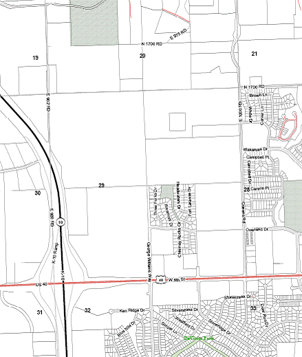
Figure 1. Location of subject property, outlined in red, within
Section 29. |