|
PLANNING COMMISSION REPORT SUMMARY Regular
Agenda -Public Hearing Item |
PDP-11-06-07: Preliminary Development Plan for The Links at
|
STAFF
RECOMMENDATION: Planning
Staff recommends approval of the requested waiver from the maximum height
limitation of 35 ft in the RM12 District in Section 20-601 of the Development
Code to permit the club house to be constructed with a maximum height of 41.6
ft. STAFF
RECOMMENDATION: Planning Staff
recommends approval of the requested waiver from the buffer area requirement
in Section 20-701(j) of the Development Code for the western property where
the adjacent property is located outside the City limits. STAFF
RECOMMENDATION: Planning Staff
recommends approval of the Links at Lawrence Preliminary Development Plan
based upon the findings of fact presented in the body of the Staff Report and
subject to the following conditions: 1.
Agreements not to protest the formation of a benefit
district must be executed by the applicant and provided to the Planning
Office before recording of the Final Development Plan for the following: a.
Street and sidewalk improvements for b.
Street and sidewalk improvements for c.
Geometric intersection improvements for d.
Intersection improvements, geometric and signalization,
for e.
Intersection improvements, geometric and signalization,
for 2.
Provision
of a revised Preliminary Development Plan with the following changes: a.
Note added to the General Notes on the Cover Sheet, Sheet
CO.0 to indicate that ‘The density of the development is limited to 6
dwelling units per acre per condition of approval of the RM12 Zoning
[Z-11-28A-07].’ b.
Remove waiver #2 on the Cover Sheet, Sheet CO.0, which
requests a waiver from the 800 ft block length Code requirement. This
requirement applies to local streets only. c.
Dimensions must be noted for the 6’ sidewalk on the east
side of the extension of George Williams Way and the 5’ sidewalk on the west
side of Queens Road. d.
Figures in the site summary table for bicycle parking must
be revised to correct the bicycle parking requirement for the Clubhouse from
‘1 per 10 auto spaces’ to ‘5 or 1 per4 auto spaces, whichever is greater’,
and the number of bicycle parking spaces required for the pool must be
corrected to read ‘3’ rather than ‘4’. e.
The pool
requires 2 f.
The 46.11
acres which is being designated as Common Open Space must be delineated on
the plan and noted in the legend. The legend should also indicate that the
31.32 acres containing the shaded golf areas and the pool area make up the
open recreation area. g.
A note must be placed on the Preliminary Development Plan
stating that prior to any construction activity the perimeter of the wooded
areas adjacent to the construction activity will be fenced at the drip line and
signage erected stating that any construction activity, grading, trenching or
storage is prohibited within the fenced area. h.
i.
Additional
landscaping must be shown on the plan to provide separation between the
parking modules, per Section 90-913(j). j.
Western
parking area, parallel with k.
Note added
stating that the use of the club house and pool is restricted to members only
or to residents of The Links at l.
Note added stating that the temporary easement for the
sanitary sewer interceptor will be 100’ during construction (30’ additional
on each side of the easement shown), and permanent easement will be 40’, as
shown. m.
The golf cart and pedestrian crossings shown across n.
Typical parking detail note on page CO.1 regarding
typical curbing must be revised to read ‘typical curbing’ rather than
‘typical curb or sidewalk’. o.
General note added stating that the horizontal separation
between all sanitary sewer lines and water lines is 10’ or more. p.
Note added to the plan stating that building permits can
not be obtained until streets are installed which are a minimum of 20’ wide
and have the first lift of asphalt. q.
Any approved waivers or modifications must be noted on
the face of the plan. r.
Note 23 on Landscaping plan, (Sheet L1.2) must be revised
to read ‘All parking areas are screened from street R.O.W. with a 10’ wide landscaping area containing
shade or ornamental trees at the rate
of 1 tree per 20 linear feet of parking area and coniferous shrubs
(Seagreen junipers) as shown and berming. Such berming shall be a minimum of
two feet in height. (new text is in bold print) s.
The t.
Parking detail on page CO.1 must be revised to show dimensions for u.
Access restrictions must be shown and noted on the Plan. The
area on Links Drive between the westernmost driveway and George Williams Way
must be marked with hatch marks to indicate ‘no access’ and Links Drive must
be marked with hatch marks to indicate ‘no access’ for 300’ from the Wakarusa
Drive / Queens Road intersection and a note added to the plan that no access
is permitted in these areas. v.
A General Note must be added stating that the City Engineer
approved the reduced driveway spacing of 270’ rather than the 300’ feet
required by Code at this location. w.
Dimensions must be shown between the two driveways being
provided on |
|
Reason for
Request: |
Proposed residential development with golf course. |
||
|
KEY POINTS ·
Environmentally
sensitive features including steep slopes and wooded areas are located on the
subject property. ·
Property
is currently outside the City limits and an annexation request has been
submitted. ·
A
modification is being requested from the ·
A
waiver is being requested from the 60’ buffer area requirement in Section 20-701(j)
along the west property line. ·
A waiver
was requested from the 800’ block length requirement in Section 20-810(c)(2)(i)
however this requirement applies only to local streets; therefore the waiver
is not necessary. |
|||
|
FACTORS TO CONSIDER ·
Conformance with the purpose of Planned
Developments (Section 20-701, Development Code). ·
Compliance with Development Code. ·
Conformance with Horizon 2020. ·
Conformance
with Subdivision Regulations. |
|||
|
ASSOCIATED
CASES/OTHER ACTION REQUIRED ANNEXATION ·
·
REZONING ·
·
DEVELOPMENT ·
·
Submittal and administrative approval of Final Development Plan. ·
Recording of Final Development Plan with the PLATTING ·
Submittal and administrative approval of Final Plat. ·
Public Improvement Plans submission to City Public Works and
Utilities Departments. ·
Recording of Final Plat with the |
|||
|
PUBLIC COMMENT RECEIVED PRIOR
TO PRINTING ·
None
received. |
|||
|
General information |
|
|
|
|
Current Zoning and Land Use: |
A (Agricultural) District; woodland and
row-crops. |
|
|
|
Surrounding Zoning: |
To the north and west: A (Agricultural) District; land outside the
incorporated city limits with agricultural uses, woodland and scattered rural
residences. To the east: RS7
(Single-dwelling Residential) District, single family residences. PRD (Westwood Hills Planned Residential
Development); property has not yet been platted or developed. To the south: RM12D (Multi-dwelling Residential) and RS7
(Single-dwelling Residential) Districts; platted subdivision which has not
yet been developed. |
|
|
|
Site
Summary |
|||
|
Lot
No. |
Area |
Building
area |
|
|
Block One |
50.62 acres (2,205,007
sq ft) |
31,600 sq ft |
1.4% |
|
Block Two |
22.10 acres (962,676 sq ft) |
16,000 sq ft |
1.7% |
|
Tract 1, Block Three |
.02
acres (871
sq ft) |
Un-buildable tract |
|
|
Total |
81.31
acres |
|
|
|
Open
Space Summary |
||||||
|
Total
Area |
Common
Open Space |
Open
Recreation Space |
||||
|
81.31 acres |
Area provided |
%
of site |
Minimum
Required |
Area provided |
% of site |
Minimum
Required |
|
46.11 acres |
56.7%
|
20%
of site 16.26
acres |
31.32 acres |
67.9% |
50% of common open space provided 23.1
acres |
|
|
Parking
Summary |
|||
|
Use |
Req.
per Sec 20-902 |
Required
Parking |
Parking
Provided |
|
Residential(800 bedrooms/ 480 dwelling units) |
1 vehicle space / bedroom + 1/10 units |
848 vehicle spaces |
848 vehicle spaces |
|
|
1 bike space/4 auto spaces |
212 bicycle spaces |
212 bicycle spaces |
|
|
2% of total - |
17 |
20 |
|
Club house (10,000 sq. ft.) |
1 vehicle space / 500 sq. ft. |
20 vehicle spaces |
20 vehicle spaces |
|
|
1 bike space/4 vehicle or 5; whichever is greater |
5 bicycle spaces |
5 bicycle spaces |
|
|
1 if 25 or fewer vehicle spaces |
1 |
1 |
|
Pool area (13,200 sq. ft) |
1 per 500 sq. ft. of activity area |
27 vehicle spaces |
27 vehicle spaces |
|
|
1 bike space / 10 auto spaces |
3 bicycle spaces |
5 bicycle spaces |
|
|
2 if between 26 and 50 vehicle spaces |
2 |
2, 1 ( van acc. ) |
|
Cart Barn 4800 sq. ft. (storage) |
No parking required |
|
|
|
TOTAL |
|
895 vehicle 20 220 bicycle |
895 vehicle 23 222 bicycle |
STAFF ANALYSIS
The property is located approximately ½ mile north of
The development proposal is for a Planned Residential Development
containing 40 multi-dwelling buildings with 12 dwelling units per building for
a total of 480 dwelling units. The buildings will be located primarily on the
more level eastern portion of the property and near the extension of
The proposed Preliminary Development Plan for The Links at Lawrence has
been evaluated based upon findings of fact and conclusions per Section 20-1304(d)(9)
of the Development Code for the City of Lawrence, requiring consideration of
the following nine items:
1) The Preliminary Development Plan’s consistency with the Comprehensive
Plan of the City.
The subject property is within the Baldwin Creek Drainage Basin, an
area in which Horizon 2020 recommends
development not be permitted until plans to extend sanitary sewer service to
the entire drainage basin have been developed.
The Department of Utilities currently has a project underway to design
and construct the West Baldwin Creek Sanitary Sewer Interceptor from pump
station PS45 located along the north edge of the Oregon Trail Addition north
and east through the subject property to the recently completed pump station
PS48. This project is as recommended in the 2003 Wastewater Master Plan and
Northwest Area Update to the Master Plan as part of the required infrastructure
to extend sanitary sewer service to the Baldwin Creek Watersheds.
The Comprehensive Plan recommends that new large-scale, low-density,
single-family residential development be located to the west of the city, with
the area east of the South Lawrence Trafficway being developed prior to the
area to the west. (page 5-4) The
proposed development is a large-scale, low-density residential development
which is proposing multi-dwelling rather than single-dwelling residences.
Policy 5.1 of the plan recommends that natural environmental features
within residential areas be preserved and protected. (page 5-19) The
Preliminary Development Plan clusters the dwelling units and parking areas so
they utilize approximately 35 acres leaving approximately 46 acres as common
open space which insures the protection of natural features and sensitive
lands.
The Comprehensive Plan recommends that Development Proposals be
reviewed for compatibility with existing land uses, including any neighborhood
plan. (Policy 4.1, page 5-17) The property lies within the boundary of The Northwest plan (1997). The Northwest
Plan recommends that residential uses vary from
Staff Finding – The proposed development complies with the
general land use provisions found in Horizon
2020 and the Northwest plan. A low-density
multi-dwelling development is unique and is being proposed here to allow for
the development of a golf course and the protection of open space and natural
features. The development does not conform strictly with the wording of the Northwest plan, but does comply with the
intent of providing low-density residential development further from
2) Preliminary Development Plan’s
consistency with the Planned Development standards of Section 20-701 including
the statement of purpose. (The statement of purpose of planned unit
developments is found in Section 20-701(a) of the Development Code]
The purpose statement includes the following:
a) Ensure
development that is consistent with the comprehensive plan. As discussed previously,
the development is consistent with the comprehensive plan and the adopted plan
for the area.
b) Ensure
that development can be conveniently, efficiently and economically served by
existing and planned utilities and services.
The City Utilities Department is implementing
a plan based on the 2003 Wastewater Master Plan which will provide sanitary
sewer service to the area. Timing of the development must coincide with the
completion of the infrastructure improvements.
Waterlines are located within the area, and the City Stormwater Engineer
indicated that the drainage study had been approved.
c) Allow
design flexibility which results in greater public benefits than could be
achieved using conventional zoning district regulations.
This area could develop as a conventional
RM12 District, however the Development Code requires that properties containing
substantial amounts of environmentally sensitive lands, as defined by Code,
must be developed as a Planned Development. Planned Developments require greater
amounts of common open space than conventional zoning districts. The benefit of
requiring development through the planned development process is the ability to
address the design of the site and the impact on the environmental features at
the preliminary plat stage (Preliminary Development Plan) and conserve as many
of the environmentally sensitive features as possible.
d) Preserve
environmental and historic resources.
There are no known historical resources in
this area. The environmental resources in the area are heavily wooded areas,
wooded slopes, and a tree lined stream. The plan concentrates development on
the more level areas which protecting the wooded slopes and many of the wooded
areas.
e) Promote
attractive and functional residential, nonresidential, and mixed-use
developments that are compatible with the character of the surrounding area.
More than 50% of the total land area is being
set aside as common open space. This large amount of open space coupled with
the protected wooded areas and the golf course landscaping will buffer the
apartment buildings from the surrounding single family homes. The buildings
will be set back from the property line, with the exception of along
The proposed development, as conditioned, meets the standards for a
Planned Development in Article 701, with waivers or modifications being
requested. The proposed development meets the minimum area requirement for a PD
district. The applicant is requesting that the
Section 20-701(j) requires that development within 60 feet of the
peripheral boundary of the PD be limited to use category, heights, setbacks and
minimum lot sizes permitted in the zoning district immediately adjoining the
proposed PD on the date of preliminary development plan approval and must
include a landscaped buffer. The
property to the west will be separated from the planned development by
Section 20-701(d) states that all of the standards of the Development
Code apply to development within a PD District except as expressly authorized
by regulations of Section 20-701. The minimum lot areas of Article 6 apply to
this development with the exception of the proposed Lot 1, Block Three which is
a remnant created by the curvature of Links Drive. This area must be designated
as Tract 1, Block Three rather than as a
|
|
|
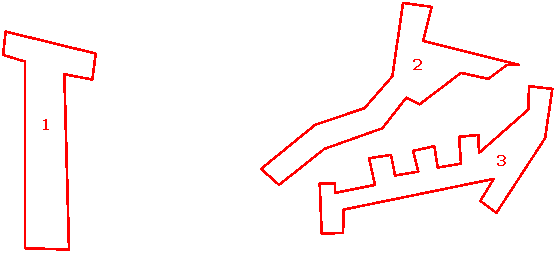
Figure 1. 3 main parking areas. |
The landscaping requirements of Article 10 apply to this development,
except as expressly authorized by Section 20-701. Article 20-1003 requires
interior parking lot landscaping for lots that are more than 150 ft deep. The parking lots in the planned development
are less than 150 ft deep, therefore the interior parking lot landscaping may
be waived. Section 20-913(j) of the Development Code requires that parking lots
with more than 220 parking spaces be divided into smaller parking modules
containing no more than 72 spaces. The plan must be revised to note the number
of parking spaces included in each parking module. The plan consists of 3
primary parking areas, each containing more than 220 parking spaces. (See
Figure 1) Parking Area 1 contains approximately 334 parking spaces, Parking
Area 2 contains approximately 237 parking spaces, and Parking Area 3 contains
approximately 296 parking spaces. Portions
of the parking areas have been broken into modules with fewer than 72 spaces;
however the north/south parking area in Parking Area 1 and the
easterly/westerly parking area in Parking Area 3 each contain more than 72
units. These parking areas must be broken into modules of 72 spaces or less,
similar to the other parking modules. All parking modules must provide adequate
landscaping on landscaped islands or peninsulas per Section 20-913(j) to reduce
the adverse visual impacts of large expanses of paving and to provide visual
separation between the modules.
The parking areas each have 2 access points onto the internal east/west
street. There is no access onto either
Section 20-915(iii) requires that driveways providing access to
collector streets shall be constructed so that the point of tangency of the
curb return radius closest to another driveway is at least 250 feet from the
perpendicular curb face of the intersecting driveway. The dimensions between the driveways being
provided along
Staff Finding – The proposed Preliminary Development Plan is
consistent with the Statement of Purpose of Planned Development. The proposed Preliminary Development Plan, as
conditioned, is consistent with the standards of Section 20-701 of the
Development Code with the exception of the proposed height of the club house, and
the required buffer along the western property line, and the applicant has
requested a modification from the
3) The nature and extent of the
common open space in the Planned Development.
Portions of the sensitive lands which include heavily wooded areas and
steep slopes will be protected and will provide common open space. The
applicant’s intent is to develop an apartment complex and golf course. The
applicant is proposing an accessory swimming pool and putt and chip area. The
golf course, swimming pool, and putt/chip area make up the open recreation
space, and are a part of the common open space.
46.11 acres, 56.7% of the site, is being set aside as common open space
and 31.32 acres, 67.9% of the common open space is being used as open
recreation. The Development Code requires that a minimum of 20% of the site
must be designated as common open space and of that 50% must be utilized as
open recreation space.
Staff Finding – The proposed Preliminary Development Plan will
provide common open space which exceeds that required by Code. The plan must
designate the area that is being set aside as Common Open Space. The plan shows
the areas where trees will be preserved by hatching and the areas which contain
the golf course as dark shaded areas. The 46.11 acres which is being designated
as Common Open Space must be delineated on the plan and noted in the legend.
The legend should indicate that the 31.32 acres made up of the shaded golf
areas and the pool area make up the open recreation area.
4) The reliability of the proposals for maintenance and conservation of
the common open space.
The plan notes that Lindsey Management will own and maintain the common
open space. The plan notes the areas to be conserved. A note must be placed on the Preliminary
Development Plan that prior to any construction activity occurring on the site,
the perimeter of the wooded areas adjacent to any construction activity will be
fenced at the drip line and signage erected which states that any construction
activity, grading, trenching or storage is prohibited within the fenced area.
Staff Finding –Lindsey Management will own and maintain the
common open space. A note must be placed on the plan to insure protection of
the common open space which contains environmentally sensitive features during
construction.
5) The adequacy or inadequacy
of the amount and function of the common open space in terms of the densities
and dwelling types proposed in the plan.
The density of the entire site is 6 units per acre; however, 38 acres
are being utilized for multi-dwelling residences which will be developed at a
density of approximately 12 units per acre. The Development Code requires 50
sq. ft. of outdoor area that can be used for recreational purposes for each dwelling
unit in a conventional RM12 District. The Code states that the required outdoor
areas serves as an alternative to a large rear setback and is an important
aspect in addressing the livability of a residential structure on a small
lot. The development plan proposes 800
dwelling units. The Development Code would require 40,000 sq. ft., (800 x 50
sq. ft) or nearly 1 acre, of outdoor area to mitigate the small lot size in a
conventional RM12 Zoning District. This development is being designed as a
planned development but the apartments are located on small lots, similar to the
conventional RM12 zoning district. Where 40,000 sq. ft. would adequately
mitigate the smaller lots, per Code, the Preliminary Development Plan provides
approximately 46 acres of common open space. Approximately 15 acres will remain
wooded and will provide a scenic, natural area for the site. The remainder,
approximately 31 acres, will be developed as a golf course, putt/chip area, and
a swimming pool which will provide recreational opportunities for residents.
Staff Finding – The amount and function of the common open
space is adequate based on the overall density and the actual density of the
areas developed for residential uses. The dwelling types are apartment
buildings which will contain 12 dwelling units apiece. The amount of open space
being provided exceeds that required by the Development Code to mitigate the
smaller lots in the conventional RM12 District.
6) Whether the Preliminary Development Plan makes adequate provisions
for public services, provides adequate control over vehicular traffic, and
furthers the amenities of light and air, recreation and visual enjoyment.
The Fire Code requires that fire hydrants be provided at 600’ intervals
along street frontage. The Preliminary Development Plan must be revised to show
fire hydrants at 600’ intervals, per the Fire Inspector’s approval. The Fire
Code was revised and new developments are required to have streets installed
prior to the issuance of building permits. The applicant met with City Staff
prior to the new Code being adopted and was told at that time that the
development could proceed under the previous standards. Fire access must be
provided to the site which is acceptable to the Fire Marshall prior to building
permits being issues. The Fire Marshall indicated that the first lift of the
asphalt on streets which are a minimum of 20 ft wide would provide acceptable
access.
The development is designed to further the amenities of light and air,
recreation and visual enjoyment. Wooded areas will be conserved to provide
visual enjoyment. The large amount of common open space will provide ample
light and air. There will be several opportunities for recreational enjoyment
on the site. The golf-course, putt/chip area, and swimming pool are part of the
common open space being provided as open recreational space. A club house will
be located near the pool, which will provide indoor recreation. A bike/rec path
will be installed on one side of
Staff Finding – The Preliminary Development Plan’s provisions
for Fire/Medical access have been approved by the Fire Marshall. The
Preliminary Development Plan has made adequate provisions for public services
and provides adequate control over vehicular traffic through limited access
points onto
7) Whether the plan will
measurable and adversely impact development or conservation of the neighborhood
area by:
a) doubling or more the traffic
generated by the neighborhood;
The City Transportation Planner indicated that the development would
increase the traffic in the neighborhood by more than double; but pointed out
that there is little development existing in the area. The residential area to
the east of
b) proposing housing types,
building heights or building massings that are incompatible with the
established neighborhood pattern; or
The housing types and massings are not compatible with the established
neighborhood pattern. Many of the residences in the area are two stories so the
height is not an issue. The houses located along
Property to the south has been platted as a residential subdivision. Links
Drive will separate the Links buildings from the residences to the south. South
of Links Drive will be residences, most of which face away from
The land to the west, across
Golf courses and open space abut the northern property line. The
buildings are located at least 160 ft into the interior of the site, behind the
golf course. The building type and massing should have minimal impact on the
existing rural residences or on future development to the north.
c) increasing the residential
density 34% or more above the density of adjacent residential properties.
The properties to the north and west are outside the city limit and are
zoned for agricultural uses. The property to the east is zoned for RS7
(Single-dwelling Residential) uses with a maximum density of 6.2 units per
acre. To the south is a platted subdivision, which has not yet been
constructed. The properties in this subdivision are zoned for RS7
(Single-dwelling Residential), RM12 (Multi-dwelling Residential) and RM12D
(Multi-dwelling Residential, duplex) uses. The densities to the south are a
maximum of 6.2 and 12 units per acre. The proposed density of the Links
development is 6 units per acre. The development will not increase the
residential density above the density of adjacent residential properties at
all.
Staff Finding –Staff has determined that the Preliminary
Development Plan will not have measurable and adverse impact on the development
or conservation of the neighborhood area. The density is less or similar to
surrounding residential properties and the buffering provided by the building
setbacks and the golf course will minimize any negative impacts the
multi-dwelling structures may have on adjacent properties.
8) Whether potential adverse
impacts have been mitigated to the maximum practical extent.
The parking areas location within the interior of the site should
prevent any glare or spill-over light onto adjacent properties. A photometric
plan will be required at the final development plan stage to insure there is no
adverse impact from the proposed exterior lighting. The recreational facilities are located in
the center of the site and should not impact the surrounding properties. The
golf course is listed as being private, for public use and use may be
determined by membership or on a ‘pay and play’ basis. To insure that the club house and pool remain accessory uses to
the apartment complex and do not become commercial facilities, a note must be
placed on the plan indicating that the club house and pool is open to members
only or to residents of The Links at
Staff Finding –
The adverse impacts of the development will be addressed with a
photometric plan to insure there is no spillover light, the location of the
recreational facilities in the center of the site insulates the noise and
activity from surrounding properties. The use of the golf course, club house
and pool may have an adverse effect on the neighborhood---depending on how it is
used; therefore a note restricting the use of the club house and pool to
residents, guests and members must be placed on the plan.
9) The sufficiency of the terms
and conditions proposed to protect the interest of the public and the residents
of the Planned Unit Development in the case of a plan that proposes development
over a period of years.
Staff Finding- A phased development has not been proposed.
Staff Review and Conclusion
The City Engineer indicated that
The proposed Preliminary Development Plan conforms to the anticipated
land use for this area as stated in the Comprehensive Plan, and Northwest plan and 6th & K-10/South Lawrence
Trafficway Nodal Plan . The development will conserve environmentally
sensitive lands while providing multi-dwelling residences at a density similar
to single-family units (6 units per acre). The topography of the site prohibits
the extension of
The applicant provided revised plans after the Staff Report had been
completed. Staff completed a preliminary review of the revised plans and
changed the conditions of approval to reflect the revisions made. When Staff
has completed a thorough review of the plans additional changes may be required
to the conditions of approval. Any additional changes to the conditions of
approval will be noted in a memorandum and included in the Communications
Packet at the Monday meeting.
Figure 1.
Intersection traffic conflict points comparison between direct and offset
drives.