|
PLANNING
COMMISSION REPORT SUMMARY REGULAR AGENDA - NON-PUBLIC HEARING ITEM |
PC Staff Report
|
ITEM
NO. 4A: ANNEXATION OF 81.13 ACRES; SUMMARY A-11-07-07: Annexation of approximately 81.13 acres located at the intersection
of |
|
|
Applicant’s Reason for Request: |
“Development
of 81.13 acres currently zoned Ag to allow for multi-family apartment complex
(480 units) with a private golf course open to the public.” |
|
KEY
POINTS ·
Subject property is located within Service Area 2
of the Urban Growth Area. ·
Request is accompanied by rezoning applications
and a preliminary development plan. |
|
|
COMPREHENSIVE
PLAN CONSIDERATION ·
Extension of public facilities and services are
required and are planned to serve this property, which is located in Service
Area 2 of the Urban Growth Area. ·
The proposal is compliant with the Comprehensive
Plan. |
|
|
ASSOCIATED CASES/OTHER ACTION REQUIRED ANNEXATION REZONINGS
DEVELOPMENT
PLANS
PLATTING
|
|
|
PUBLIC COMMENT RECEIVED PRIOR TO PRINTING ·
No public comment was received in the Planning
Office prior to printing this report. |
|
|
GENERAL INFORMATION |
||
|
Current Zoning and Land Use: |
A
(Agricultural) District;
Agricultural uses and woodland. |
|
|
Surrounding Zoning and Land Use: |
To the south: RM12D
(Multi-dwelling Residential) District, RS7 (Single-dwelling Residential)
District; Platted as the Oregon Trail Addition, not yet developed To the east: RS7
(Single-dwelling Residential) District; Single-dwelling residences. PRD-Westwood
Hills (Planned Residential Development) District; Zoned as part of the
Westwood Hills Planned Development, but property has not been platted nor has
a Final Development Plan been approved for this portion. Agricultural uses. To the north
and west: A
(Agricultural) District; Agricultural uses, wooded areas and scattered rural
residences. |
|
Site Summary
|
||
|
Gross Area: Gross Area being requested for
annexation: |
81.31 acres 81.31 acres |
|
|
Subject property is located within
Service Area 2 as defined in Horizon
2020. |
||
STAFF REVIEW
Annexation Procedure and
General Location:
The subject property is adjacent to the
northern city limits, west of
Site
Characteristics:
The subject property is bordered on the east
by
|
|
|
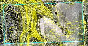
Figure 1. Contour map of subject property. |
|
|
|
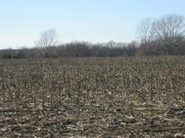
Figure 2. View west of |
Infrastructure
and Utility Extension:
Sanitary
Sewer: The Department of Utilities currently has a project underway
to design and construct the West Baldwin Creek Sanitary Sewer Interceptor from
pump station PS45 located along the north edge of the Oregon Trail Addition
north and east through the subject property to the recently completed pump
station PS48. This project is as recommended in the 2003 Wastewater Master Plan
and Northwest Area Update to the Master Plan as part of the required
infrastructure to extend sanitary sewer service to the Baldwin Creek
Watersheds. The location of this sewer line and easement has been established
and final design phase services are being negotiated. This extension of the
sanitary sewer system has been designed to accommodate development of the
subject tract. Note there is no sanitary sewer service available to this tract
until the completion of the West Baldwin Creek Interceptor project, but plans
are being implemented which will provide sanitary sewer service. While the
development will contain multi-dwelling residential units with the open space
proposed for the golf course the resulting density will be similar to that of
single-dwelling residential dwellings.
Waterlines: A waterline is
located east of
Private
Utilities: Electric, phone, and gas utilities will have to be extended to this
property and easements will be provided with the plat.
Aquilla has a 4” high pressure plastic gas
main on the north side of
Public
Right-of-Way: The development is adjacent to
COMPREHENSIVE
PLAN:
The focus of this
discussion will be the overall annexation as it relates to growth management
and residential development. The subject property is located within Service
Area 2 of the Urban Growth Area as shown in Map 3-1 of Horizon 2020. This area is anticipated for development in
the future, coincident with the improvements, construction and extension of
major utilities and streets.
Several goals and
policies are provided in Horizon 2020 related to development timing and are
found in Chapter 4, Growth Management. Growth management is defined as the
primary tool for ensuring timely and orderly growth. This tool includes
specific annexation policies and the establishment of an Urban Growth Area and
service delivery areas for the purpose of extending municipal utilities. “The growth management policies seek to
ensure that adequate facilities and services are provided or assured in
connection with development.” (Horizon
2020, page 4-1). The intent of the
Growth Management recommendations is to insure that infrastructure and utility
service is available to development and to coordinate development with the
timing of improvements. The City Utilities Engineer reviewed the Downstream
Sanitary Sewer Analysis and determined that improvements being made to the
sanitary sewer system in the area would provide capacity for this development,
but noted there is no sanitary sewer service available to this tract until the
completion of the West Baldwin Creek Interceptor project.
The City of
The Annexation
Policies listed on page 4-3 of Horizon
2020 states that
Horizon 2020 discusses Service Area 2 on Page 4-2 and
recommends that urban development not be allowed in the
Chapter Five –
The proposal complies with Horizon
2020 Growth Management recommendations and annexation policies.
Design and land use criteria
are considered and discussed in the related rezoning requests and Preliminary
Development Plan.
SUMMARY OF LAND USE AND REQUEST:
Annexation is being
requested to allow the development of low-density dwelling units with a golf
course and protected wooded areas. A
portion of the subject property is undeveloped woodland and the eastern portion
is in agricultural production. The property is zoned A (Agricultural) District.
Agricultural land uses, which include farm residences, are permitted in these
districts.
The property contains
a stream, a large wooded area and steep slopes. The development is proposed as
a Planned Development to protect the environmentally sensitive features on the
property. Rezoning requests to the RM12 (Multi-dwelling Residential) District
and the RM12-PD (Multi-dwelling Residential Planned Development) Overlay
District have been submitted for this property.
The Rural Water
District serving this area has no facilities on the property, so compensation
will not be necessary. The Utilities Department has developed and is
implementing a plan which will provide sanitary sewer service for the entire
Baldwin Creek Drainage Area, as recommended in H2020. The development of
the property must be timed to coordinate with the completion of the sanitary sewer
infrastructure improvements and with the installation of City standards roads
to access the development. The applicant must work with the City Engineer to
determine the time frame for the future improvements to