PLANNING COMMISSION REPORT
Regular Agenda – Public Hearing Item
PC Staff Report
12/17/07
ITEM NO. 3 : RS7 TO GPI; 50 ACRES; 1910, 2110, 2120 HARPER ST (MKM)
Z-11-29-07: A request to rezone a tract of land approximately 50 acres, from RS7 (Single-Dwelling Residential) to GPI (General Public & Institutional). The property is the Douglas County Fairgrounds, located at 1910, 2110, 2120 Harper Street. Submitted by Pam Madl, Assistant Douglas County Administrator, for Douglas County, property owner of record.
|
STAFF RECOMMENDATION: Staff recommends approval of the rezoning request [Z-10-29-07] for approximately 50 acres from RS7 (Single-dwelling Residential) District to GPI (General Public and Institutional Use) District and forwarding it to the City Commission with a recommendation for approval based on the findings of fact found in the body of the staff report. |
Applicant’s reason for request: “Change in zoning requirements for RS-7 Districts has required rezoning for this property in order to offer ‘entertainment and spectator sports’ on its premises.”
KEY POINTS
· The fairground was established in the early 1950s.
· The fairgrounds exhibit halls, arenas and carnival area are non-conforming uses subject to the restrictions in Article 15 of the Development Code.
GOLDEN FACTORS TO CONSIDER
CHARACTER OF THE AREA
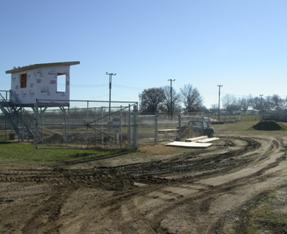
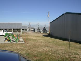
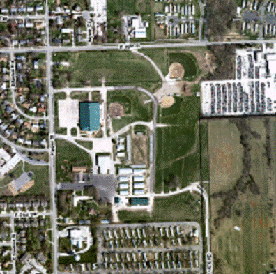
· The property, located at the southeast corner of the Harper Street / E 19th Street intersection contains the Douglas County Fairgrounds which includes some paved parking areas and enclosed buildings, such as the Douglas County Extension Office, 4-H Buildings and the Community Building. The remainder of the property contains graveled parking areas and open air structures for display of 4-H animals, rodeo/demolition derby grounds, carnival grounds, ball fields and other community events. There are a variety of land uses in the area with the majority being residential. There is an established single-family neighborhood and an elementary school across Harper St. to the west, and mobile home parks to both the north and south. Non-residential uses in the area include a church and the City animal shelter to the north, a school to the west, a fire/medical facility to the south, and an auto recycling/salvage facility and industrial property outside the city limits to the east. (See figures 1-3)
CONFORMANCE WITH HORIZON 2020
§ The proposed rezoning request from RS7 to GPI is consistent with land use recommendations found in Horizon 2020.
ASSOCIATED CASES/OTHER ACTION REQUIRED
§ Approval of rezoning request by the City Commission and publication of ordinance.
PUBLIC COMMENT RECEIVED PRIOR TO PRINTING
· No public comment has been received prior to the printing of this staff report.
GENERAL INFORMATION
|
Current Zoning and Land Use:
|
RS7 (Single-dwelling Residential) District; Douglas County Fairground
|
|
Surrounding Zoning and Land Use: |
To the north: RS7 (Single-dwelling Residential) District and PID (Planned Industrial Development) District; single-dwelling residences, church, mobile home park and animal shelter.
To the west: RS7 (Single-dwelling Residential) District and GPI (General Public and Institutional Use) district; established single-family neighborhood and elementary school.
To the south: GPI (General Public and Institutional Use) District and RS7 (Single-dwelling Residential) District; City fire/medical station and mobile home park.
To the east: IG (General Industrial) and property outside the city limits zoned I-1 (Limited Industrial District); Auto recycling/salvaging facility and unused property outside the city limits which was used previously as a chemical processing facility. |
1. CONFORMANCE WITH THE COMPREHENSIVE PLAN
Applicant’s Response:
“This request fits in with ‘Goal 2: Protect the existing Parks, Recreation and Open Space System’ in that it is necessary to rezone this property in order to protect it as an entertainment venue. The property needs to be zoned in such a way that ‘active recreation, entertainment, and spectator sports’ are permitted uses in order for the facility to be maintained and enhanced. (H2020, 9-14).”
Chapter Nine of Horizon 2020 provides strategies for park, recreation, open space areas and facilities. One strategy recommends that the community’s park, recreation, and open space system be developed and improved, building upon the existing system. (page 9-2) The Fairgrounds is an existing recreation facility which was established prior to the adoption of the 1966 Zoning Ordinance. The property was zoned RS-2 with the adoption of the Zoning Ordinance and the zoning converted to the RS7 with the adoption of the Development Code in 2006. A recreation facility such as the fairgrounds is not a permitted use in the RS7 District. The fairgrounds is currently a ‘non-conforming use’ as defined in Section 20-1502(a) “A nonconforming use is a land use that was legally established, but that is no longer allowed by the use regulations of the zoning district in which it is located.” There are limits on the amount of expansion permitted for non-conforming uses; therefore, it would not be possible to ‘continue to develop and improve’ the facility as recommended by Horizon 2020 under the current zoning.
Goal 2 of Chapter Nine (page 9-14) contains recommendations for the protection and enhancement of existing park, recreation and open space areas. As the applicant noted one recommendation is to maintain and enhance the existing facilities.
The Lawrence Future Land Use Map in Horizon 2020 (Map 3-2) indicates that this area is planned for ‘parks, recreation, and open space uses’.
Staff Finding -- Zoning the property GPI is in conformance with the recommendations of the comprehensive plan.
II. ZONING AND USE OF NEARBY PROPERTY, INCLUDING OVERLAY ZONING
Staff Finding -- There are a variety of zoning districts and land uses nearby. The majority of the surrounding property to the north, west and south is zoned RS7 (Single-dwelling Residential) District and contains detached single-family homes and two mobile home parks. Non-residential uses are located in all directions: to the north is a one-lot Planned Industrial District (PID) which contains the Lawrence Humane Society, the area animal shelter, and a church; to the south and west are properties zoned GPI (General Public and Institutional) District which contain a City fire/medical station and an elementary school, and to the east are industrially zoned properties (both within and outside the City limits) which contains a salvage yard and a chemical processing facility which is currently vacant.
III. CHARACTER OF THE AREA
The property is located on the eastern border of the City, with a portion of the eastern property line adjacent to property outside the incorporated city limits. The property is east of Harper Street and south of E 19th Street, which are both designated as ‘major collectors’ on the Major Thoroughfares Map. This is primarily a residential area with single-family detached homes and mobile home parks which also contains general public uses such as an elementary school, a fire/medical station and an animal shelter. This area is characterized by the integration of compatible uses including varying types of residences, school, church, fire/medical station, and a recreational facility. The fairground serves as a buffer between the area and the industrial uses to the east.
Staff Finding -- The area contains many components of a neighborhood: varying types of residences, a church, a school, a fire/medical station, light industrial, and a recreation/open space facility.
IV. PLANS FOR THE AREA OR NEIGHBORHOOD, AS REFLECTED IN ADOPTED AREA AND/OR SECTOR PLANS INCLUDING THE PROPERTY OR ADJOINING PROPERTY
This area has not been the subject of any area or sector plans. Plans for East Lawrence, East Lawrence Plan, Far East Lawrence Neighborhood Plan, BrookCreek Corridor Plan, and East Lawrence Revitalization Plan did not extend to this area. A Master Plan for the fairgrounds was provided and reviewed with the 1999 UPR. A revised Master Plan was provided with the site plan submitted for the addition of the Dreher Hall, 4-H building addition [SP-09-65-07].
Staff Finding -- No individual plans have been developed for this area to date. The use is compliant with the land use recommended in the Future Land Use Map in Horizon 2020.
V. SUITABILITY OF SUBJECT PROPERTY FOR THE USES TO WHICH IT HAS BEEN RESTRICTED UNDER THE EXISTING ZONING REGULATIONS
Applicant’s response:
“The property would continue to be used for the same uses for which it’s been operating.”
The subject property is zoned RS7 (Single-dwelling Residential) District. Section 20-1725 of the Development Code defines ‘Entertainment and Spectator Sports, General’ as the provision of cultural, entertainment, athletic, and other events to spectators. The use also includes events involving social or fraternal gatherings. Those uses which generate an attendance of 501 or more people, such as exhibition halls, field houses, stadiums and sports complexes are classified as ‘general’. Entertainment and Spectator Sports, General are not a permitted use in the RS7 District. The Fairgrounds is currently a ‘non-conforming use’ and subject to the restrictions in Article 15 of the Development Code.
Staff Finding -- The fairground is not a permitted use in the zoning district in which it is located; therefore the subject property is not suitable for the uses to which it has been restricted. The use is permitted in the GPI District with a Special Use Permit (SUP); therefore the rezoning to GPI would be appropriate.
VI. LENGTH OF TIME SUBJECT PROPERTY HAS REMAINED VACANT AS ZONED
Staff Finding – The property is currently developed with the Douglas County Fairgrounds. The fairgrounds were established in 1951 and the first buildings were constructed between 1951 and 1955.
VII. EXTENT TO WHICH APPROVING THE REZONING WILL DETRIMENTALLY AFFECT NEARBY PROPERTIES
Applicant’s response:
“The requested rezoning will not affect the existing use of the property and will not have any detrimental effect on nearby properties.”
The fairground is currently a non-conforming use in that it was legally established, but is not a permitted use in the 2006 Development Code. A non-conforming use is permitted to remain but there are restrictions on the expansion of the use, and if the structure were destroyed it would not be permitted to be rebuilt. The Fairgrounds is a community and neighborhood amenity. If the rezoning was not approved, limitations would be placed on the types of improvements and expansions which could be made to the facility. The fairgrounds is classified as a General Entertainment and Spectator Sports use in the GPI District for which rezoning is being requested. This use requires approval of a Special Use Permit in the GPI District, which includes a public hearing and approval by the City Commission. The rezoning would permit the fairgrounds to make improvements while protecting the interests of nearby property owners and residents through the Special Use Permit process.
Staff Finding – The rezoning would not detrimentally affect nearby properties. The rezoning would permit the fairgrounds to make improvements while protecting the interests of nearby property owners and residents through the Special Use Permit process.
VIII. RELATIVE GAIN TO THE PUBLIC HEALTH, SAFETY AND WELFARE BY THE DESTRUCTION OF THE VALUE OF THE PETITIONER’S PROPERTY AS COMPARED TO THE HARDSHIP IMPOSED UPON THE INDIVIDUAL LANDOWNERS
Applicant’s response:
“The public would gain in continuing to have use of the property for ‘entertainment and spectator sports’ throughout the year, and especially during the Douglas County Fair.”
Evaluation of these criteria includes weighing the benefits to the public versus the benefits of the owner of the subject property. Benefits are measured based on the anticipated impacts of the rezoning request on the public health, safety and welfare.
Staff Finding -- The benefit to the public health, safety and welfare would be to allow improvements to occur at the fairgrounds which would increase the usefulness and enjoyment of the site. Significant alterations to the site, if zoned GPI, would require a change to the Special Use Permit, which would include a public hearing for public input and would require City Commission approval. If the rezoning request were denied, any plans to expand the use which exceeded those permitted in Article 15 of the Development Code would not be possible without relocating the fairgrounds.
STAFF REVIEW
The subject property was developed with the Douglas County Fairgrounds between 1951 and 1955, prior to annexation and rezoning. The property was rezoned to the RS-2 (Single-family Residence) District in 1966 when the City adopted the 1966 Zoning Ordinance. Community Buildings were permitted under the 1966 Zoning Ordinance in residentially zoned districts through the Use Permitted upon Review (UPR) process. In 1999 a community building was approved for the Fairgrounds with a UPR. In 2006 the City adopted the Development Code which revised many features of the zoning ordinance, including the zoning districts and permitted uses. The zoning district designation converted from RS-2 to RS7 (Single-dwelling Residential) District. Per the Permitted Use Table in Article 4 of the Development Code, lodge, fraternal and civic assembly, such as the meeting buildings for the 4-H groups and active recreation uses such as the ball fields are permitted uses in the RS7 District requiring a Special Use Permit; however, the indoor and outdoor arena areas, exhibit areas and carnival grounds (Entertainment & Spectator Sports, General) are not permitted in the RS7 District.
Currently, the fairground is a non-conforming use. Article 15 of the Development Code regulates the amount of expansion possible for non-conforming uses and Section 20-1502(c)(2) states that when a building or structure containing a non-conforming use is damaged to the extent of more than 60% of its fair market value, the use may not be restored. Therefore, rezoning the subject property to the GPI District will not only provide a zoning district that accurately reflects the existing land use on the property, but will also allow for the structures housing the arenas and exhibit halls to be rebuilt if damaged and will make possible future improvements or expansions.
The Development Code requires that substantial alterations to the site be approved through the Special Use Permit Process, which includes a public hearing component and requires approval of the City Commission; thereby protecting the interests of the nearby residential properties.
|
|
|
Figure 1. Aerial of the fairgrounds and surrounding area. |

|
|
|
|
|
Figure 2. Rodeo / demolition derby arena |
Figure 3. Fairground animal shelters and exhibit areas. |