(Published in Lawrence Daily Journal-World on February ____, 2008)
RESOLUTION NO. 6749
A RESOLUTION OF THE GOVERNING BODY OF THE CITY OF LAWRENCE, KANSAS ESTABLISHING THE DATE AND TIME OF A PUBLIC HEARING REGARDING THE ESTABLISHMENT OF A REDEVELOPMENT DISTRICT PURSUANT TO K.S.A. 12-1770 ET SEQ. FOR THE 12TH & OREAD PROJECT
BE IT RESOLVED BY THE GOVERNING BODY OF THE CITY OF LAWRENCE, KANSAS:
Section 1. The City of Lawrence, Kansas (the “City”) is considering the establishment of a redevelopment district pursuant to K.S.A. 12-1770 et seq., as amended (the “Act”).
Section 2. Notice is hereby given that a public hearing will be held by the City to consider establishment of a redevelopment district on February 12, 2008 in the City Commission Chambers located in City Hall, 6 East 6th Street, commencing at 6:35 p.m..
Section 3. The proposed redevelopment district boundaries are irregular and extend from 13th Street on the South to approximately 9th Street on the North and Mississippi on the West and Louisiana on the East. A map of the redevelopment district is attached hereto as Exhibit A. The boundaries of the redevelopment district are legally described as shown on Exhibit B hereto.
Section 4. The district plan for the proposed redevelopment district provides for the redevelopment district to include One project area, which is depicted on the map attached hereto as Exhibit A. The buildings and facilities to be constructed within the one project area are generally described as follows:
A multi-use structure consisting of approximately 106 rooms and associated commercial spaces. These rooms include approximately 92 hotel rooms and extended stay suites, and approximately 14 condominiums. The structure will include ancillary uses such as meeting and conference rooms, banquet rooms, restaurant space, and bar space. Additional commercial uses may consist of a bank, retail stores, and other similar commercial uses allowed by the City of Lawrence. The structure will consist of approximately 116,000 square feet and will be seven stories tall. The structure shall include an underground parking facility consisting of approximately 200 spaces. The redevelopment will also include public infrastructure improvements including without limitation improvements to Oread Avenue, 12th Street, pedestrian access, utilities, landscaping, and other related improvements.
Section 5. A description and map of the proposed redevelopment district are available for inspection and copying in the offices of the City Clerk, City Hall, 6 East 6th Street, Lawrence, Kansas, Monday through Friday (other than holidays) between 8:00 a.m. and 5:00 p.m.
Section 6. The Governing Body will consider the findings necessary for the establishment of a redevelopment district after conclusion of the public hearing.
Section 7. The City Clerk is hereby authorized and directed to publish this resolution once in the official city newspaper not less than one week or more than two weeks preceding February 12, 2008, the date set for the public hearing. The City Clerk is also authorized and directed to mail a copy of this resolution via certified mail, return receipt requested to the board of county commissioners, the board of education of any school district levying taxes on property within the proposed redevelopment district, and to each owner and occupant of land within the proposed redevelopment district, not more than 10 days following the date of the adoption of this Resolution.
Section 8. This Resolution shall become effective upon its adoption by the Governing Body.
ADOPTED by the Governing Body this January 8, 2008.
SIGNED by the Mayor this January 8, 2008.
___________________________________
Mayor
(SEAL)
___________________________________
City Clerk
EXHIBIT A
MAP OF PROPOSED REDEVELOPMENT DISTRICT
|
|
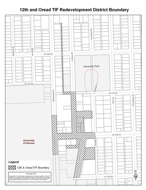
EXHIBIT B
LEGAL DESCRIPTION OF PROPOSED REDEVELOPMENT DISTRICT
Beginning at the Intersection of the Centerline of Louisiana Street and the South Right-of-way line of West 12th Street (Hancock Street) in the Southeast Quarter (SE ¼) of Section 36, Township 12 South, Range 19 East of the Sixth Principal Meridian in the City of Lawrence, Douglas County, Kansas; thence West on the South Right-of-way line of West 12th Street (Hancock Street) extended to the Northeast Corner of Lot 1, Block 3, Oread Addition; thence continuing West on the South Right-of-way line of said West 12th Street (Hancock Street) to the Northwest corner of Lot 1, Block 3, Oread Addition; thence in a Southwesterly direction on the East Right-of-way line of Oread Avenue to the Northwest corner of the South One-half (S ½) of Lot 2, Block 3, Oread Addition; thence East on the North line of the South one-half (S ½) of said Lot 2 to the Northeast corner of the South One-half (S ½) of said Lot 2; thence South on the East line of said Block 3 Oread Addition to the Southeast corner of the North One-half (N ½) of Lot 4, Block 3 of Oread Addition; thence West on the South line of the North One-half (N ½) of Lot 4, Block 3 of Oread Addition to the Southwest corner of the North One-half (N ½) of Lot 4, Block 3 of Oread Addition and the East Right-of-way line of Oread Avenue; thence in a Southwesterly direction on the East Right-of-way line of Oread Avenue to the Southwest corner of Lot 6, of Oread Heights Addition, A Subdivision of Block 3, Oread Addition; thence continuing in a Southwesterly direction on the East Right-of-way line of Oread Avenue extended to the Centerline of 13th Street (Lee Street); thence West on the Centerline of said 13th Street (Lee Street) to the West Right-of-way line of Oread Avenue; thence in a Northeasterly direction on the West Right-of-way line of Oread Avenue to the Southeast corner of the North One-half (N ½) of Lot 2, Block 8 of Oread Addition; thence West on the South line of the North One-half (N ½) of Lot 2, Block 8 of Oread Addition to the Southwest corner of North One-half (N ½) of Lot 2, Block 8 of Oread Addition; thence North on the West line of the North One-half (N ½) of Lot 2, Block 8 of Oread Addition to the Southwest corner of Lot 1, Block 8 of Oread Addition; thence East on the South line of Lot 1, Block 8 of Oread Addition 180 feet; thence North parallel with the West line of Lot 1, Block 8 of Oread Addition to the South Right-of-way line of 12th Street (Hancock Street); thence West on the South Right-of-way line of 12th Street (Hancock Street) to the Northwest corner of Lot 12, Block 8 of Oread Addition and the East Right-of-way line of Mississippi Street; thence South on the East Right-of-way line of Mississippi Street to the Southwest corner of the North One-half (N ½) of Lot 10, Block 8 of Oread Addition; thence West on the South line of the North One-half (N ½) of Lot 10, Block 8 of Oread Addition projected West, to the West Right-of-way line of Mississippi Street; thence North on the West Right-of-way line of Mississippi Street to the intersection of the North line of Lot 9, Block 9 of Oread Addition projected West; thence East on the North line of Lot 9, Block 9 of Oread Addition extended, to the Northwest corner of Lot 9, Block 9 of Oread Addition and the East Right-of-way line of Mississippi Street; thence South on the East Right-of-way line of Mississippi Street to the Southwest corner of Lot 7, Block 9 Oread Addition, and the North Right-of-way line of 12th Street (Hancock Street); thence East on the North Right-of-way line of 12th Street (Hancock Street) to the Southeast corner of Lot 6, Block 9 of Oread Addition and the West Right-of-way line of Indiana Street; thence North on the West Right-of-way line of Indiana Street to the Northeast corner of Lot 1, Block 9 of Oread Addition and the Southeast corner of Lot 3, Block 14, Lane’s Second Addition; thence continuing North on the West Right-of-way line of Indiana Street to the Northeast corner of Lot 1, Block 14, Lane’s Second Addition and the South Right-of-way line of 11th Street (Quincy Street); thence West on the South Right-of-way line of 11th Street (Quincy Street) to the intersection of the East line of Lots 13 thru 24, Block 13, Lane’s Second Addition projected South; thence North on the East line of Lots 13 thru 24, Block 13, Lane’s Second Addition extended, to the Southeast corner of Lot 13, Block 13, Lane’s Second Addition and the North Right-of-way line of 11th Street (Quincy Street); thence North on the East line of Lots 13 thru 24, Block 13, Lane’s Second Addition to the Northeast corner of Lot 24, Block 13, Lane’s Second Addition and the South Right-of-way line of 10th Street (Berkeley Street); thence continuing North on the East line of Lots 13 thru 24, Block 13, Lane’s Second Addition projected North to the Southeast corner of Lot 15, Block 11 Lane’s Second Addition; thence North on the East line of Lots 15 thru 23, Block 11, Lane’s Second Addition to the Northeast corner of Lot 23, Block 11, Lane’s Second Addition; thence North on the East line of Lots 15 thru 23, Block 11, Lane’s Second Addition projected North, to the South line of Lot 3, Block 11, Lane’s Second Addition; thence East on the South line of Lot 3, Block 11, Lane’s Second Addition to the intersection of the West line of Lots 6 thru 14, Block 11, Lane’s Second Addition projected North; thence South on the West line of Lots 6 thru 14, Block 11, Lane’s Second Addition extended, to the Northwest corner of Lot 6, Block 11, Lane’s Second Addition; thence South on the West line of Lots 6 thru 14, Block 11, Lane’s Second Addition to the Southwest corner of Lot 14, Block 11, Lane’s Second Addition and the North Right-of-way line of 10th Street (Berkeley Street); thence South on the West line of Lots 6 thru 14, Block 11, Lane’s Second Addition extended, to the Northwest corner of Lot 1, Block 13, Lane’s Second Addition, and the South Right-of-way line of 10th Street (Berkeley Street); thence South on the West line of Lots 1 thru 12, Block 13, Lane’s Second Addition to the Southwest corner of Lot 12, Block 13 Lane’s Second Addition and the North Right-of-way line of 11th Street (Quincy Street); thence East on the South line of Lot 12, Block 13, Lane’s Second Addition and the North Right-of-way line of 11th Street (Quincy Street) to the Southeast corner of Lot 12, Block 13 Lane’s Second Addition; thence continuing East on the North Right-of-way line of 11th Street (Quincy Street) extended to the Southwest corner of University Park (Northeast corner of 11th Street (Quincy Street) and Indiana Street); thence South on the East Right-of-way line of Indiana Street projected North from Block 15, Lane’s Second Addition to the Northwest corner of Lot 6, Block 15, Lane’s Second Addition; thence South on the East Right-of-way line of Indiana Street to the Southwest corner of Lot 4, Block 15, Lane’s Second Addition and the Northwest corner of Lot 12, Block 2, Oread Addition; thence continuing South on the East Right-of-way line of Indiana Street to the Northwest corner of the South 60 feet of Lot 9, Block 2, Oread Addition; thence East on the North line of the South 60 feet of Lot 9, Block 2, Oread Addition to the Northeast corner of the South 60 feet of Lot 9, Block 2, Oread Addition; thence South on the East line of Lots 9, 8, and 7, Block 2, Oread Addition to the Southeast corner of Lot 7, Block 2, Oread addition and the North Right-of-way line of 12th Street (Hancock Street); thence East on the North Right-of-way line of 12th Street (Hancock Street) to the Southeast corner of Lot 6, Block 2, Oread Addition; thence continuing East on the North Right-of-way line of 12th Street (Hancock Street) extended to the Centerline of Louisiana Street; thence South on the Centerline of Louisiana Street to the Point of Beginning; Containing 7.84 Acres more or less all in the City of Lawrence, Douglas County, Kansas.
And the following additional property described as follows:
Plate U04543B, Twenty Four Company, LC, South 55 feet of Lot 3, North 65 feet of Lot 4, North 40 feet of Lot 9, and the South 55 feet of Lot 10, all in Block 2, in Oread Addition.
Including any and all rights-of-way and public easements adjacent to the above described property."
EXCERPT OF MINUTES OF A MEETING
OF THE GOVERNING BODY OF
CITY OF LAWRENCE, KANSAS
HELD ON JANUARY 8, 2008
The governing body met in regular session at the usual meeting place in the City, at 6:35 pm., the following members being present and participating, to-wit:
Absent:
The Mayor declared that a quorum was present and called the meeting to order.
* * * * * * * * * * * * * *
(Other Proceedings)
The matter of calling a public hearing to establish the date and time of a public hearing regarding the establishment of a redevelopment district within the City came on for consideration and was discussed.
Commissioner ________________ presented and moved the adoption of a Resolution entitled:
A RESOLUTION OF THE GOVERNING BODY OF THE CITY OF LAWRENCE, KANSAS ESTABLISHING THE DATE AND TIME OF A PUBLIC HEARING REGARDING THE ESTABLISHMENT OF A REDEVELOPMENT DISTRICT PURSUANT TO K.S.A. 12-1770 ET SEQ. FOR THE 12TH & OREAD PROJECT
Commissioner ________________ seconded the motion to adopt the Resolution. Thereupon, the Resolution was read and considered, and, the question being put to a roll call vote, the vote thereon was as follows:
Aye: ________________________________________________________________________.
Nay: ________________________________________________________________________.
The Mayor declared the Resolution duly adopted; the Clerk designating the same Resolution No. ______.
* * * * * * * * * * * * * *
(Other Proceedings)
[BALANCE OF THIS PAGE INTENTIONALLY LEFT BLANK]
* * * * * * * * * * * * * *
CERTIFICATE
I hereby certify that the foregoing Excerpt of Minutes is a true and correct excerpt of the proceedings of the governing body of the City of Lawrence, Kansas, held on the date stated therein, and that the official minutes of such proceedings are on file in my office.
(SEAL)
Clerk