|
PLANNING |
MEMO |
|
|
|
|
|
|
|
|
|
|
|
|
|
|
|
|
OFFICE |
|
To: |
Lawrence-Douglas County Planning Commission |
|
From: |
Planning Staff |
|
Subject: |
|
|
Date: |
November 28, 2007 |
Project History
The original Southern Development Plan was completed and adopted on March 1, 1994 by the City Commission. The plan is currently thirteen years old and considered out of date. At the November 15, 2006 Planning Commission meeting, the commission directed the Comprehensive Plans Committee (CPC) to revise and update the Southern Development Plan to direct future land use in the area. The CPC worked to update the plan and expanded the planning area beyond the original boundaries. The new planning area is bounded roughly to the north by W. 31st Street and the properties north of W. 31st Street between Ousdahl Road and Louisiana Street; to the west by E. 1150 Road (Kasold Drive) extended; to the south by the north side of the Wakarusa River; and to the east by E. 1500 Road (Haskell Avenue).
A property owner meeting was held on June 7, 2007 to introduce the first draft of the plan to property owners and interested persons in order to request feedback. Comments regarding the draft were collected and then discussed by the CPC. A second draft was completed and incorporates a number of the comments given at the public meeting. The second draft was posted on the Planning Department website in mid-July to allow for the public to view the document.
The draft Revised Southern Development Plan includes an introduction section, an existing condition section, and a recommendations section. The introduction section provides the background and purpose of the plan, a description of the planning area, and the policy framework for the plan.
Recommendation/Action History
The following is a summary of the recommendations and actions made on the Revised Southern Development Plan draft to date. The commissions did not agree specifically on the future land use classification of one property located northwest of the intersection of E. 31st and Louisiana Streets (Snodgrass property). The draft of the plan that was considered identified the property as low-density residential. Because the City and County Commissions did not agree on a draft of the plan, the plan has been sent back to the Planning Commission for further consideration.
- Horizon 2020: Identifies the property as low-density residential
- CPC/Staff: Recommended low-density residential for the property
- Planning Commission: Recommended medium-density residential on August 29th (8-1)
- City Commission: Approved low-density residential on September 25th (5-0)
- Board of County Commissioners: Approved medium-density residential on October 8th (2-1)
Analysis and Staff Review
The single item that the three commissions did not agree on is the land use classification of the property at the northwest corner of Louisiana and E. 31st Street (Snodgrass property). Staff has completed additional analysis of the property in question as well as the nearby development pattern in the adjacent neighborhood. The area of the neighborhood that was analyzed is the area bounded on the north by W. 27th Street, on the west by Naismith Valley Park, on the east by Louisiana Street, and on the south by the Snodgrass property.
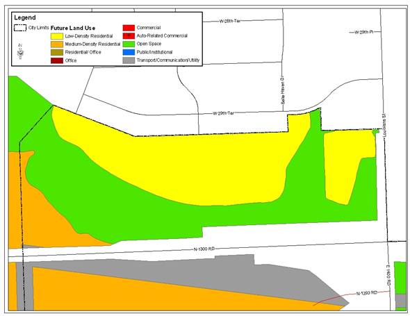
Snodgrass Property
Property at the northwest corner of Louisiana and E. 31st Streets
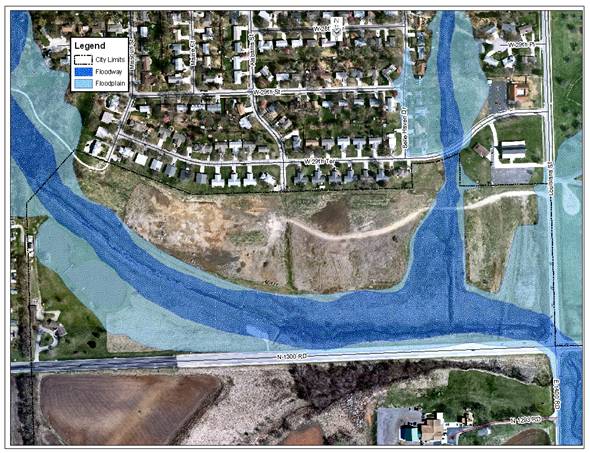
- Property is split by FEMA designated floodplain and floodway
- Site area: 17.20 acres and 3.35 acres = 20.55 gross acres
- At 6 units/acre based on gross acreage
- 103.2 units and 20.1 units = 123.3 units
- At 15 units/acre based on gross acreage
- 258 units and 50.25 units = 308.25 units
- At RM12D zoning (12 units/acre) based on gross acreage
- 124.87 units and 24.3 units = 149.17 units
- No local street access to an arterial street (E. 31st and Louisiana Streets) unless there are no other feasible options.
- Horizon 2020 identifies the area as low-density residential
The property at the northwest corner of E. 31st and Louisiana Streets (Snodgrass property) is separated into two areas by floodplain and floodway. The total acreage that is not located within the floodplain is approximately 20.55 acres. This property currently has no platted lots or streets so possible density is calculated based on gross square feet. The gross density is the maximum number and does not take into consideration the requirements of the Land Development Code regarding street right-of-way, building setbacks, parking requirements, etc. The highest density in the range for the low-density residential land use category is 6 dwelling units per acre which would allow for a maximum of approximately 123 total units (using gross acreage). The highest density in the range for the medium-density residential land use category is 15 dwelling units per acre which would allow for a maximum of approximately 308 total units (using gross acreage). The density was also calculated for the RM12D District which is considered low-medium density residential. This would allow for a maximum of approximately 149 total units (using gross acreage).
The Snodgrass property has two arterial streets that abut the property, Louisiana Street to the east and E. 31st Street to the south. Local street connections to an arterial street should not intersect and will only be approved when it is found that such connection is part of the best traffic solution for the new subdivision and where the subdivider will add turn lanes or other improvements recommended by the City Engineer (Section 20-810(d)(3)(i)).
There are also two local streets that are stubbed into this property and the possibility for a third. The third street extension could happen where the property abuts W. 29th Street. Belle Haven Drive could be extended to the south if needed.
Horizon
2020 Future Land Use Zoomed In

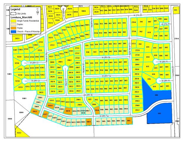
Neighborhood to the north
- Area looked at is bounded on the north by W. 27th Street, on the west by Naismith Valley Park, on the east by Louisiana Street, and on the south by the Snodgrass property
- 253 residential parcels
- 7 triplex structures, 29 duplex structures, and 217 single-family structures = 253 structures
- 79 multi-family units + 217 single-family units = 296 units
- Area: 88.13 gross acres
- 3.3 units per acre gross density
- Lot sizes range from 4,472 sq. ft. to 29,933 sq. ft. (average of 12,058 sq. ft.)
- 2 existing street stubs to the south into future area (Missouri and Alabama Streets)
The portion of the neighborhood to the north (Indian Hills Neighborhood) that was analyzed is the area bounded on the north by W. 27th Street, on the west by Naismith Valley Park, on the east by Louisiana Street, and on the south by the Snodgrass property. This area was platted in 1965 and the average lot sized is 12,058 square feet which is, on average, larger than the lots typically being platted in new subdivisions. The area contains approximately 88.13 gross acres, divided into 253 parcels with 7 triplex structures, 29 duplex structures, and 217 single-family structures. The area contains 79 multi-family units, and 217 single-family units totaling 296 units. The area has an approximate gross density of 3.3 units per acre.
There are two platted, stubbed streets into the Snodgrass property. Both Missouri and Alabama Streets stub into the Snodgrass property from the neighborhood. Belle Haven Drive has the possibility to be extended into the Snodgrass property in the future if needed.
After further analysis, staff believes that it is appropriate to retain the low-density residential land use designation on the Snodgrass property. This determination is based on the existing gross density of the neighborhood to the north and the possible gross density for the Snodgrass property. The addition of the RM12D District zoning and attached dwelling and duplex structure types to the low-density residential use category would offer the opportunity for the development of the vacant property to develop with multi-family structures (attached dwellings and duplexes) at a low-density residential level.
Staff Recommendation
Staff recommends approval of the Revised Southern Development Plan with the following additions and forwarding the recommendation to the City and County Commissions for approval:
• Add a reference to T2030 and subsequent transportation plans.
• Retain Snodgrass property as low-density residential
• Add to the low-density residential land use description the following:
– Zoning Districts: add RM12D District
– Primary Uses: add attached dwellings and duplexes