|
PLANNING |
MEMO |
|
|
|
|
|
|
|
|
|
|
|
|
|
|
|
|
OFFICE |
|
To: |
Lawrence-Douglas County Planning Commission |
|
From: |
Planning Staff |
|
Subject: |
PC Agenda Item 12: Revised Southern Development Plan ADDENDUM |
|
Date: |
November 28, 2007 |
Since the original staff report was distributed, staff has met with the property owner at the northwest corner of W. 31st and Louisiana Streets and representatives from the Indian Hills Neighborhood. Additional analysis was completed regarding the transition of densities from the single-family residential pattern to the north to the multi-family residential pattern approaching W. 31st Street.
Analysis and Staff Review
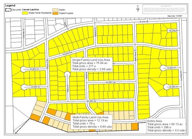
Additional review of the neighborhood area to break out the multi-family residential from the single-family residential in order to calculate gross density of each individual land use was completed. This analysis is described below.
- Single-family Area
- Total gross area = 75.94 ac
- Total gross density = 2.86 u/a
- Multi-family Area
- Total gross area = 12.19 ac
- Total gross density = 6.48 u/a
- Entire Area
- Total gross area = 88.12 ac
- Total gross density = 3.3 u/a
This analysis demonstrates that it would be appropriate to have medium-density residential development on the Snodgrass property with a density cap of 8 dwelling units per acre and with a residential development pattern similar to the developed neighborhood to the north. The property owner and neighborhood representation have agreed that this would be an acceptable land use designation for the Snodgrass property. This agreement is reflected in the staff recommendation below and should supersede staff’s previous recommendation.
Staff Recommendation
Staff recommends approval of the Revised Southern Development Plan with the following changes and forwarding the recommendation to the City and County Commissions for approval:
• Add a reference to T2030 and subsequent transportation plans.
• Change low-density residential land use description the following ways:
– Remove under applicable areas: Property to the north and west of the intersection of Louisiana Street and W. 31st Street.
– Add to the Zoning Districts: RM12D
– Add to the Primary Uses: attached dwellings and duplexes
• Change medium-density residential land use description to add:
– Add to the Applicable Areas: Property to the north and west of the intersection of Louisiana Street and W. 31st Street.
– Add to the Primary Uses: attached dwellings
• Change the Policies under residential to add:
– 5. Property northwest of the intersection of W. 31st and Louisiana Streets, north of the FEMA designated floodplain shall:
• have a gross density of no more than 8 dwelling units per acre,
• be restricted to the following zoning districts: RS7 (Single-Dwelling Residential), RS5 (Single-Dwelling Residential), PD (Planned Development Overlay), RM12D (Multi-Dwelling Duplex Residential),
• develop with any of the following uses: single-family dwellings, attached dwellings, duplex, and
• develop with similar residential character to the neighborhood to the north.
• Change the Policies under Commercial to state:
– 2. Planned development overlay zonings shall be self-contained with consideration given to: independent traffic networks; land use buffers; and/or a gradation of land uses, as well as, landscaped buffer(s) along the perimeter of the planned commercial development.
– 3. Future commercial development and/or redevelopments of existing commercial areas shall be in the form of planned development overlays.
• Change the Policies under Open Space/Floodplain to state:
– 3. Areas within the regulatory floodplain shall not be counted as contributing more than 50% of the open space used in the computation of density for planned development overlays e.g., areas designated as open space/floodplain cannot be used to justify increased residential development densities.