|
PLANNING COMMISSION REPORT SUMMARY
REGULAR AGENDA - NON-PUBLIC HEARING ITEM |
PC Staff Report
|
ITEM NO. 9A: ANNEXATION OF 52 ACRES; 31ST & OUSDAHL (MKM)
SUMMARY A-05-04-07: Annexation of approximately 52 acres located at 31st & Ousdahl. Submitted by Professional Engineering Consultants, P.A., for RA & JG Limited Company, property owner of record.
|
|
STAFF RECOMMENDATION: Staff recommends approval of the requested annexation of approximately 52 acres located at the southeast corner of the intersection of W 31st Street and Ousdahl Road and forwarding it to the City Commission with a recommendation for approval based on the findings found in the body of the staff report subject to the following condition:
1. Prior to issuance of any building permit the funds must be placed in escrow for the future modification and decommissioning of the temporary pump station.
|
|
Applicant’s Reason for Request: |
Annexation required for urban development and extension of municipal utilities.
|
|
KEY POINTS · Request is for annexation of 52 acres to allow for multi-family residential development on the northern 13.4 acres (and the adjacent 11.2 acres which are within the City limits); with no development proposed at this time for the southern 38.6 acres. · Subject property is located within Service Area 1 of the Urban Growth Area. · Request is accompanied by two rezoning applications and a preliminary plat.
|
|
|
COMPREHENSIVE PLAN CONSIDERATION
|
|
|
ASSOCIATED CASES/OTHER ACTION REQUIRED Zoning
Platting
Development
|
|
|
PUBLIC COMMENT RECEIVED PRIOR TO PRINTING · Call from Jeanne Ellermeir of Indian Hills Neighborhood Association questioning the submittal of the plan before the Southern Development Plan was complete. |
|
|
GENERAL INFORMATION |
||
|
Current Zoning and Land Use: |
RS10 (Single-dwelling Residential) and A (Agricultural) Districts; agricultural uses-row crops.
|
|
|
Surrounding Zoning and Land Use: |
To the north, across 31st Street: RS10 (Single-dwelling Residential) District; Gaslight Village Mobile Home Park.
To the west are four zoning districts: CS (Commercial Strip) District; a mini-storage facility, auto/tire service center, and Wal-Mart GPI (General Public and Institutional); a post office; PCD [Pine Ridge Plaza] District; a narrow strip of undeveloped land along Ousdahl Road and beyond that the Pine Ridge Plaza Shopping Center with commercial uses. RS7 (Single-dwelling Residential) District; stormwater detention pond behind Wal-Mart.
To the south and east: A (Agricultural) District; this land lies outside the Incorporated City Limits; Agricultural uses and scattered rural residences.
|
|
Site Summary |
||
|
Gross Area: Gross Area being requested for annexation: |
63.11 acres 52 acres
|
|
|
Subject property is located within Service Area 1 as defined in Horizon 2020.
|
||
STAFF REVIEW
An earlier annexation request for the acreage in Phase I had been submitted to the Planning Commission in November, 2006. Planning Commission voted to forward the annexation request to the City Commission with a recommendation for approval. The applicant asked that the item be deferred from the City Commission agenda and has submitted this annexation request for the land in both phases of the development. A copy of the November Planning Commission meeting minutes is included in Appendix C.
Annexation Procedure and General Location:
The site is generally described as being located on the southeast corner of the intersection of W 31st Street and Ousdahl Road. The property is adjacent to existing City limits on the north and west property lines. Access to the property will be provided from Ousdahl Road but will not be allowed within 300’ of the Ousdahl Road/31st Street intersection. Ousdahl Road is designated as a ‘collector street’ on the current street classification map and the future major thoroughfares map. W 31st Street is designated as a ‘minor arterial’ on the current street classification map and a ‘principal arterial’ on the future major thoroughfares map. No access will be permitted onto W 31st Street.
Kansas Law [K.S.A. 12-510 et. seq.] provides for annexation by ordinance of the City Commission. Lawrence City policy requires the Lawrence-Douglas County Metropolitan Planning Commission review all annexation requests in excess of ten acres. Upon annexation, the property is required to be rezoned to a compatible city classification. A related rezoning request has been submitted for RM15, a multi-dwelling residential zoning district with a maximum allowed density of 15 units per acre for the northern 24.5 acres of the annexation request and a rezoning request for UR (Urban Reserve) has been submitted for the southern 38.6 acres of the annexation request).
Site Characteristics:
The subject property is adjacent to existing city limits along the north and west sides and is within Service Area 1 of the Urban Growth Area. The property has very little slope and is planted in row crops. There is no floodplain located on the property.
Infrastructure and Utility Extension:
The subject property is currently undeveloped and development will require the extension of municipal services. One standard condition of annexation is that the applicant is responsible for providing the City compensation for any rural water district facilities located on the property prior to annexation of the property. There are no rural water district facilities located on the property.
The City Utilities Department has reviewed the proposed development request in conjunction with a Downstream Sanitary Sewer Analysis provided by the applicant as part of the submittal requirements. The Utilities Department informed Planning Staff and the applicant that capacity is not currently available for the 36” sanitary sewer interceptor through the proposed development as this line currently experiences surcharge conditions after rain events. The Department of Utilities therefore recommends that no new connections be allowed to this line until relief is provided with the construction of the Wakarusa Water Reclamation Facility and the redirection of a portion of the current flow on this line to the new facility.
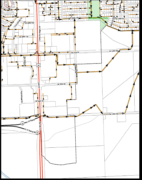
The Utilities Engineer stated that development can proceed in advance of the scheduled relief for the northern 36” line only if an alternate means for provision of sanitary sewer service is provided by the applicant and approved by the City Utilities Department. The applicant has proposed construction of a temporary pump station to convey flows to the 24” interceptor along the southern portion of the property. The referenced sewer lines are shown in Figure 1.
The following requirements would apply to the alternate means of provision of sanitary sewer services:
- the pump station must be located on property owned by the City, (an agreement to revert to the original owner can be executed, in the event that the pump station is abandoned);
- funds would need to be placed in an escrow account to finance the additional operational expenses as well as the decommissioning and modifications required to establish the gravity connection, or a special assessment benefit district could be established;
- The City must have access to the pump station at all times, and adequate space must be provided for the Utilities Department to park equipment (an access easement would guarantee the City access to the pump station).
The City Utilities Department has approved the Downstream Sanitary Sewer Analysis for this portion in terms of available capacity in the 24” line south of the subject property. Connection is still subject to the submittal and approval of sanitary sewer public improvement plans, including those for the proposed temporary pump station. All public improvements shall be designed and constructed in accordance with the City of Lawrence Department of Utilities Standard Specifications and Design Criteria. The future development proposal for Phase II must submit a Downstream Sanitary Sewer Analysis and capacity for this future development will be determined at that time.
An annexation request for the northern 13.3 acres was submitted and recommended for approval at the November 15, 2006 Planning Commission meeting. The Planning Commission voted 5-5 to approve the rezoning which constitutes a recommendation for denial and voted to defer the preliminary plat. The applicant is submitting a new application which includes the northern and southern portions of the property they are interested in developing. Title and easement issues, which have since been resolved, prevented this property from being included in the earlier annexation request. The Utilities Department stated that all subsequent expansions of the proposed development beyond the proposed north 30 acres shall require additional analysis for available capacity and approval of public improvement plans.
The City Utilities Department indicated that it will be necessary to extend the waterline along W 31st Street from Ousdahl to the east property line. The proposal for temporary sanitary sewer pump station is under review by the Department of Utilities. Capacity in the gravity, 36” sewer line through the property is not available. The size of the proposed pump station and access to be determined during detailed design phase. The pump station design is to be reviewed and approved by the Department of Utilities.
Private Utilities: Electric, phone, and gas, extensions will have to be made to this property for private utility service and easements will be provided with the plat.
Public Right-of-Way: The property is located at the intersection of existing streets. No new streets need to be constructed to accommodate the proposed development. The City Engineer indicated that adequate right-of-way exists for Ousdahl however Ousdahl should be extended to the southern property line to provide connectivity to the south. The existing portion of Ousdahl is a collector and has 80’ of right-of-way. The City Engineer recommends that 80’ of right of way be dedicated for the future extension of Ousdahl to the southern property line. This extension will occur when the southern portion of the property is developed. The Future Major Thoroughfares Map shows a minor arterial which requires 100’ of right-of-way being located along the eastern side of the subject property. One-half the needed right-of-way, 50’, is being dedicated with the plat for this future street. The applicant will execute an agreement not to protest the formation of a benefit district for the construction of this road with the plat. W 33rd Street should be extended to the east to connect with the future minor arterial or with Louisiana when the property to the east develops. The applicant is dedicating an additional 25’ of right-of-way for W 31st Street as recommended in the 31st Street Corridor study. The City Traffic Engineer recommended the applicant dedicate right-of-way for a roundabout at the 33rd and Ousdahl intersection.
Other Services: Southern Star Gas indicated they had an easement running north and south through the property. The applicant is working with Southern Star Gas on this easement. No other departments have commented on the proposed development with regard to service delivery.
COMPREHENSIVE PLAN:
The focus of this discussion will be the overall annexation as it relates to growth management. The subject property is located within Service Area 1 of the Urban Growth Area and the future land use is shown as ‘office/public’ on Map 3.1 Urban Growth Area and Future Land Use of Horizon 2020. Land uses are generally defined for Service Area 1 and are discussed in the related rezoning staff reports (Z-05-05-07 and Z-05-06-07). Service Area 1 includes lands which are proximate to the existing city limits and can be readily served by community facilities and services. Future development is anticipated for Service Area 1 coincident with the improvements, construction and extension of major utilities and streets.
Several goals and policies are provided in Horizon 2020 related to development timing and are found in Chapter 4, Growth Management. Growth management is the fundamental tool for ensuring timely and orderly growth. This tool includes specific annexation policies and the establishment of an Urban Growth Area and service delivery areas for the purpose of extending municipal utilities. The growth management policies seek to ensure that adequate facilities and services are provided or assured in connection with development. The subject property is located within Service Area 1 which includes lands which are proximate to the existing city limits and can be readily served by community facilities and services. “Non-agricultural types of uses within Service Area 1 shall not proceed until the property: is annexed into the city; has access to public utilities and services, is platted and [zoned] to a city zoning category.” (Horizon 2020 page 4-1)
Growth Management Policies
Policy 1.5(b): Require property in Service Area 1 to annex prior to development.
Policy 3.1 (b): Developments in need of the extension of city utilities or city services shall first be required to annex.
Policy 3.3 (b): Whenever an opportunity arises to annex portions of the immediate growth areas, such annexation should be executed by the City Commission.
Growth Management policies address the need to evaluate the proposed development with respect to the provision of services, protection of topographic and drainage concerns, and applicable land use criteria. Horizon 2020 gives priority to properties that abut existing city limits. It also supports the approach that adequate facilities and services are provided or assured in connection with development. (page 4-1) The proposed annexation request is consistent with the Growth Management Polices found in Horizon 2020.
The Annexation Policies listed on page 4-3 of Horizon 2020 states that Lawrence will actively seek voluntary annexation of land within the UGA as development is proposed and annexation shall be required to develop land which is in Service Area 1. As this property is located within Service Area 1, annexation is required prior to development. The annexation request is consistent with the Annexation Policy of the City of Lawrence.
The City of Lawrence Administrative Annexation Policy (AP-74) requires that the costs associated with compensation to a Rural Water District be paid to the City by the annexation applicant for Rural Water District facilities serving the property to be annexed. The Rural Water Districts Map shows this area as being served by well water. Staff checked with personnel of Rural Water District #5, the water district to the south of this property, who confirmed that there are no rural water district facilities serving this property.
Design and land use criteria are considered and discussed in the related rezoning and preliminary plat staff reports.
SUMMARY OF LAND USE AND REQUEST:
The land is currently zoned for agricultural and low density residential uses. The property is contiguous to City limits. Surrounding City property is developed with high-intensity commercial and medium-density residential uses. The proposed land use is a multi-dwelling medium density residential development. The land use is discussed in more detail in the rezoning request.
The subject property is located within the area anticipated for future urban growth. Horizon 2020 supports an approach that adequate facilities and services are provided or assured in connection with development. Municipal utilities must be extended to serve this area. Sanitary Sewer capacity does not exist at this time, but an alternative means of providing sanitary sewer service will be provided by the applicant, with funds being placed in escrow for the decommissioning of the temporary pump station and modifications needed to convert the service to a gravity line. The City Utilities Department requires the applicant provide sanitary sewer public improvement plans before connection to the City line will be approved.
|
Northern 36” sewer line. (No capacity until possibly after the
Wakarusa Water Reclamation Facility built.) Southern 24” sewer line. (Flow would be directed to this line
with the proposed alternative.) |
||||
|
Figure 1. Sanitary sewer lines located near the 31st Street and Ousdahl Road Intersection. The northern line does not have sufficient capacity for this proposed development so the southern line will be used as an alternative. |

|
|