|
PLANNING COMMISSION REPORT Regular Agenda – Public Hearing Item |
PC Staff Report
10/24/07
ITEM NO. 20A: IG TO OS; 1.80 ACRES; 900 E. 15th ST (MJL)
Z-09-21A -07: IG (General Industrial) to OS (Open Space); 1.80 acres; 900 E. 15th Street (Initiated by Planning Commission on 8/29/07)
|
STAFF RECOMMENDATION: o Approval of the rezoning of approximately 1.80 acres from IG District to OS District and forwarding a recommendation for approval to the City Commission based on the findings in the body of the staff report. |
|
|
Reasons for Request: |
To follow up on intended zoning discussed in the approved police evidence storage site plan and zone accordingly. The approved site plan indicated on that upon adoption of the Land Development Code, this property shall be initiated to be rezoned to the GPI and OS Districts. Also to zone for consistency with the approved Burroughs Creek Trail & Park Master Plan project. |
|
KEY POINTS
|
|
|
GOLDEN FACTORS TO CONSIDER CHARACTER OF THE AREA
CONFORMANCE WITH HORIZON 2020
|
|
|
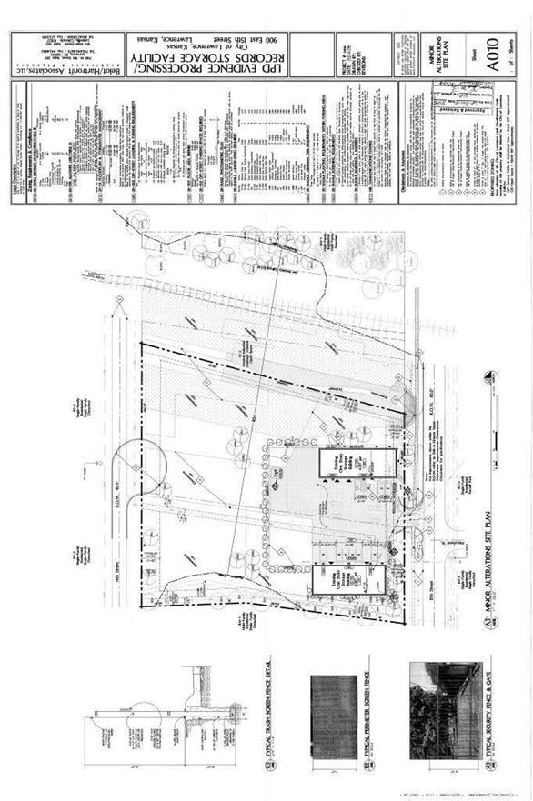
ASSOCIATED CASES/OTHER ACTION REQUIRED · Z-09-21-07B: IG to GPI; 1.13 acres; 900 E. 15th Street · SP-09-61-04: Site plan for the police evidence facility (Approved by CC 12/14/04)
|
|
|
PUBLIC COMMENT RECEIVED PRIOR TO PRINTING
|
|
GENERAL INFORMATION |
|
|
Current Zoning and Land Use: |
IG (General Industrial) District; the subject property is currently developed with two structures used for police evidence storage.
|
|
Surrounding Zoning and Land Use:
|
RS5 (Single-Dwelling Residential) District and RM12D (Multi-Dwelling Residential Duplex) District to the north; single-family homes, duplex, and triplex
RS7 (Single-Dwelling Residential) District and OS (Open Space) District to the south; single-family homes and Parnell Park
RM12 (Multi-Dwelling Residential) District to the west; single-family homes
RM12 (Multi-Dwelling Residential) District to the east; apartment homes |
I. ZONING AND LAND USES OF SURROUNDING PROPERTIES
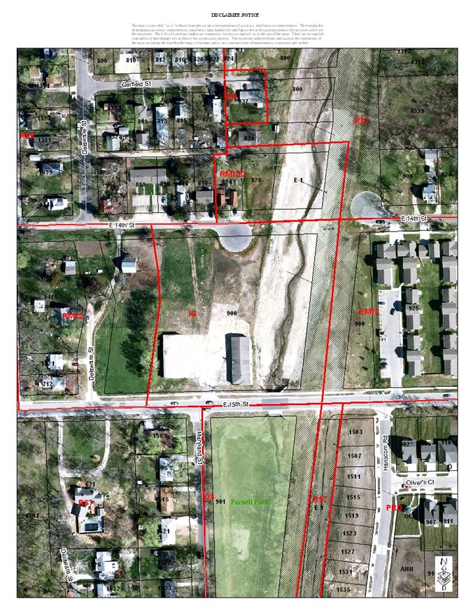
The properties directly north of the subject property are zoned RS5 and RM12D Districts and are developed with single-family homes, a duplex and a triplex. The properties to the south of the subject property are zoned RS7 and OS Districts and are developed with single-family homes and Parnell Park. The property to the west of the subject property is zoned RM12 and is developed with a residential/farm use. The property to the east of the subject property is zoned RM12 and is developed with apartment homes.
Staff Finding – The request is to rezone approximately 1.80 acres from the IG District to the OS District. This request is for the rezoning of only the portion of the site that is currently undeveloped and identified on the approved site plan as “greenspace”. The approved site plan is for the police evidence storage facility and is owned by the city. The areas surrounding the subject property is zoned for residential uses. This rezoning will allow for future redevelopment of the property for park use per the approved Burroughs Creek Corridor Trail & Park Master Plan.
The subject property is in the environs of the Samuel Riggs House located at 1501 Pennsylvania Street which is listed on the National Register of Historic Places. This requires additional review by the Historic Resources Administrator for potential impacts on the listed property. The Historic Resources Administrator has reviewed and approved the request.
This property is within the planning area of the Burroughs Creek Corridor Plan. The plan recommends that as the Burroughs Creek planning area redevelops, the emphasis should be placed on residential infill and neighborhood friendly redevelopment of industrial and commercial areas that are presently underutilized. This rezoning will also help implement the transition of the railroad right-of-way to a linear park and recreational trail.
II. CHARACTER OF THE AREA
Staff Finding – The area is characterized by a mix of residential uses and zonings.
III. SUITABILITY OF SUBJECT PROPERTY FOR THE USES TO WHICH IT HAS BEEN RESTRICTED
The subject property is currently zoned for industrial use. According to the City’s Land Development Code, the IG District requires a minimum lot area of 5,000 square feet. The general industrial district is “…primarily intended to accommodate moderate and high-impact industrial uses, including large scale or specialized industrial operations requiring good transportation access and public facilities and services.”
The request is to rezone the subject property to the OS District which has no minimum lot area requirements. The general purpose of this district is “…intended to preserve and enhance major open space and recreational areas by protecting the natural amenities they possess and by accommodating development that is compatible with those natural amenities”.
Staff Finding – Currently the property is zoned IG District and this portion of the subject property is undeveloped. The OS District zoning would generally allow development of community facilities and recreational uses, subject to any additional applicable regulation in the Land Development Code.
The subject property is currently owned by the city and a portion of the property is used as a police evidence storage facility. The approved site plan noted that upon the adoption of the Land Development Code, this property shall be initiated to be rezoned to the GPI and OS Districts. The portion being requested to be rezoned to the OS District is currently undeveloped and identified on the approved site plan as “greenspace”. This rezoning would be consistent with the approved site plan and would also give neighbors assurance that the property won’t be redeveloped with industrial uses.
This property abuts the abandoned railroad right-of-way which is identified as a future park. This rezoning would be consistent with the approved Burroughs Creek Corridor Trail & Park Master Plan to redevelop the majority of the subject property into a park facility.
IV. LENGTH OF TIME SUBJECT PROPERTY HAS REMAINED VACANT AS ZONED
Staff Finding - The subject property was zoned M-2 (General Industrial) District and RM-1 (Multiple-Family Residence) District at the adoption of the 1966 City of Lawrence Zoning Ordinance. Staff researched the zoning change for the portion of the property that was zoned RM-1 and could not find information on when it was changed. The site plan for the site that was approved in May 1977 shows the entire property being zoned M-2.
V. EXTENT TO WHICH REMOVAL OF RESTRICTIONS WILL DETRIMENTALLY AFFECT NEARBY PROPERTY
Staff Finding –The OS District is more restrictive than the current zoning. The proposed zoning would allow for community facilities and recreational uses. The use on this portion of the subject property is already restricted to greenspace per the approved site plan. This rezoning would be consistent with the approved site plan. The rezoning would also be consistent with the approved Burroughs Creek Corridor Trail & Park Master Plan to use this property in the future as a park. This would protect the neighborhood from the possible development of industrial uses on the property.
VI. RELATIVE GAIN TO THE PUBLIC HEALTH, SAFETY AND WELFARE BY THE DESTRUCTION OF THE VALUE OF THE PETITIONER’S PROPERTY AS COMPARED TO THE HARDSHIP IMPOSED UPON THE INDIVIDUAL LANDOWNERS
Evaluation of this criterion includes weighing the benefits to the public versus the benefit of the owners of the subject property. Benefits are measured based on anticipated impacts of the rezoning request on public health, safety, and welfare.
Staff Finding – If the property retains its IG District designation, it could redevelop with a variety of medium- to high-intensity industrial uses. The proposed OS District zoning will help protect the residential uses surrounding the subject property by allowing community facility and recreational facility uses. The OS District will protect the public health, safety, and welfare better by protecting existing residential uses and prevent future redevelopment of medium- to high-impact industrial uses. The city as the property owner will be able to use the property to benefit the community. This rezoning would allow the redevelopment of the property as a park facility in the future as part of the Burroughs Creek Corridor Trail & Park Master Plan.
VII. CONFORMANCE WITH THE COMPREHENSIVE PLAN
The subject property is located between E. 14th and E. 15th Streets on the north and south and Delaware Street and the abandoned railroad right-of-way (undeveloped Burroughs Creek Corridor Park and Trail) on the west and east.
The following Horizon 2020 goals and associated policies:
PARKS, RECREATION, OPEN SPACE AREAS AND FACILITIES
GOAL 2: Protect the Existing Parks, Recreation, and Open Space System (Page 9-14)
Policy 2.3: Continue Community Beautification Efforts (Page 9-14)
GOAL 3: Expand the Existing Parks, Recreation, and Open Space System (Page 9-16)
Policy 3.1: Identify Future Parklands and Open Space Areas (Page 9-16)
GOAL 4: Connectivity To, From, and Between Park, Recreation, and Open Space Areas and Facilities (Page 9-19)
Policy 4.1: Provide Connections for Pedestrian Accessibility (Page 9-19)
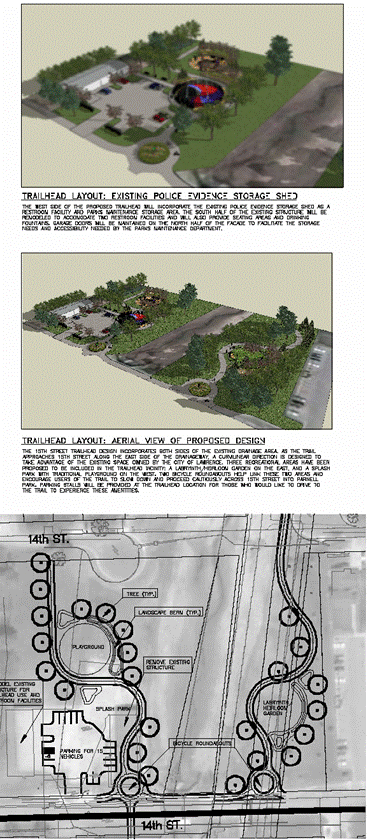
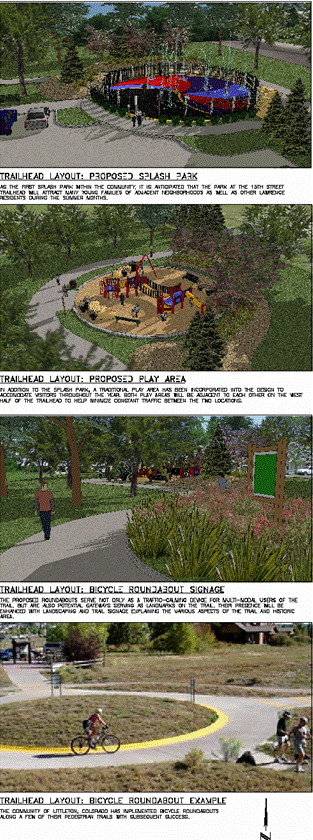
Staff Finding – The OS District conforms to several Horizon 2020 policies. This specific property is not identified in Horizon 2020 as a location for a park but is located adjacent to the identified Burroughs Creek Trail and Park. As part of the Burroughs Creek Trail & Park Master Plan process, the Parks Department identified this city owned property as a good location for a trail head for the trail and park. This would be a neighborhood friendly reuse of the current police evidence storage facility and provide an expansion to link to the planned trail system abutting to the east and the existing Parnell Park. The subject property would be an opportunity to use publicly owned space to meet community demand for facilities in this area.
STAFF REVIEW
The subject property is located between E. 14th and E. 15th Streets on the north and south and Delaware Street and the abandoned railroad right-of-way on the west and east. As previously stated, land uses surrounding the property include a variety of residential uses. The subject property is currently owned by the city and is being used by the Police Department for evidence storage. The Police Department has earmarked monies in the 2008 CIP to relocate the evidence storage facility to another location leaving the subject property unutilized. The city has recently approved the Burroughs Creek Trail & Park Master Plan that identifies the subject property to be a park. The OS District zoning would generally allow development of community facilities and recreational uses, subject to any additional applicable regulation in the Land Development Code. This rezoning would be consistent with the approved site plan for the property, the Burroughs Creek Trail & Park Master Plan, the Burroughs Creek Corridor Plan, and Horizon 2020. The Historic Resources Administrator has reviewed this request and approved it. Staff recommends approval of the rezoning from the IG District to OS District.
|
|
Approved site plan for the Police Evidence Storage Facility
Excerpts from the Burroughs Creek Corridor Park and Trail Master Plan