PLANNING COMMISSION REPORT
Regular Agenda – Public Hearing Item
ITEM NO. 7 : A & V-C TO GPI-FP; 537.70 ACRES; N 1175 ROAD & E 1600 ROAD (MKM)
Z-08-16-07: A request to rezone a tract of land approximately 537.70 acres from A (Agricultural) & V-C (Valley Channel) to GPI-FP (General Public & Institutional Floodplain Overlay). The property is located near N 1175 Road & E 1600 Road. Submitted by Bartlett & West for the City of Lawrence, property owner of record. [This is the site of the proposed Wakarusa Water Reclamation Facility. The PC recommended approval of rezoning to GPI at their 5/23/07 meeting.]
|
STAFF RECOMMENDATION: Staff recommends approval of the rezoning request for 536.88 acres from V-C (Valley Channel) and A (Agricultural) Districts to GPI-FP (General Public and Institutional with a Floodplain Overlay) District and forwarding it to the City Commission with a recommendation for approval based on the findings of fact found in the body of the staff report and subject to the following condition: 1. Recording of a final plat prior to publication of the rezoning ordinance. |
Applicant’s reason for request: “The property is being annexed and rezoned to appropriately fit within the zoning criteria described in the new City of Lawrence Land Development Code for a water reclamation facility.”
KEY POINTS
· The Planning Commission considered a rezoning request from A (Agricultural) and V-C (Valley Channel) to GPI (General Public and Institutional Use) District for this property on May 23rd, 2007 and forwarded a recommendation for approval to the City Commission.
· The property is outside the Lawrence city limits. An annexation request was also recommended for approval at the May 23rd Planning Commission meeting and forwarded to the City Commission and County Commission.
· The Floodplain Overlay District is defined differently for properties within the City and for properties which have been annexed after March 1st, 2003 per Section 20-1201 (b) and (c). The Floodplain Overlay District for properties which are annexed after March 1, 2003 include additional lands than those shown on the Flood Insurance Rate Maps (FIRM) or the Flood Insurance Study (FIS) and zoning is necessary to place these lands within the Overlay District.
GOLDEN FACTORS TO CONSIDER
CHARACTER OF THE AREA
· The property is encumbered with floodplain and floodway. The site has been used for agricultural purposes and has never been developed. The property lies near the intersection of two local roads, and is bounded on two sides by waterways making it an isolated location.
CONFORMANCE WITH HORIZON 2020
§ The proposed rezoning request from V-C (Valley Channel) and A (Agricultural) Districts to GPI-FP (General Public and Institutional with Floodplain Overlay) District is consistent with land use recommendations found in Horizon 2020.
ASSOCIATED CASES/OTHER ACTION REQUIRED
Applications which were considered at the May Planning Commission:
· Annexation request [A-04-02-07] for 536.88 acres. Forwarded to City Commission with recommendation for approval.
· Special Use Permit [SUP-04-04-07] for Wakarusa Water Reclamation Facility. Forwarded to City Commission with recommendation for approval.
· Preliminary Plat [PP-04-04-07] for Wakarusa Water Reclamation Facility Addition, a one lot subdivision. Approved and forwarded to the City Commission for acceptance of dedication of easements and rights-of-way.
· Zoning request [Z-04-04-07] for 536.88 acres from A and V-C to GPI (General Public and Institutional Use) District. Forwarded to City Commission with recommendation for approval.
Other Action:
· Board of County Commissioners finding that the annexation will not hinder the orderly growth and development of the community. (Scheduled for 9/19/07 meeting).
· City Commission actions:
· Approval of annexation.
· Acceptance of easements and road right-of-ways as shown on the preliminary plat.
· Final Plat submitted to Planning Office for administrative approval and recordation at the Douglas County Register of Deeds.
· Publication of Zoning and Annexation Ordinances.
· Submittal and administrative review of site plan and floodplain development permit for each phase of the development, in conformance with the Special Use Permit.
· NPDES permit from the Kansas Department of Health and Environment.
· Dedicated truck route selected by County and City Staff.
· Minimum maintenance road designations reversed for N 1175 and E 1600 Roads as they will be utilized for access.
PUBLIC COMMENT RECEIVED PRIOR TO PRINTING
· No public comments have been received prior to printing this report.
GENERAL INFORMATION
|
Current Zoning and Land Use:
Surrounding Zoning and Land Use: |
V-C (Valley Channel) and A (Agricultural) Districts and Floodplain Overlay District / Rezoning request to GPI (General Public and Institutional Use) District has been recommended for approval; Agricultural uses and wooded waterway corridors.
To the west: A (Agricultural) and V-C (Valley Channel) Districts and Floodplain Overlay District; Agricultural uses and scattered rural residences.
To the south: A (Agricultural) District and V-C (Valley Channel) Districts and Floodplain Overlay District; Agricultural uses and scattered rural residences.
To the east: A (Agricultural) District and Floodplain Overlay District; Agricultural uses, wooded areas and scattered rural residences.
To the north: V-C (Valley Channel) District and Floodplain Overlay District; Wakarusa River and agricultural uses.
|
I. ZONING AND LAND USES OF SURROUNDING PROPERTIES
Staff Finding -- The property lies south of the Wakarusa River and west of Coal Creek. The subject property is encumbered with floodplain which extends into the surrounding area, primarily to the south and east. The surrounding property is currently zoned V-C and A. The predominate land uses in the area are agriculture and scattered rural residences. A rezoning request from V-C and A to GPI (General Public and Institutional Use) District was recommended for approval subject to the condition that a final plat be recorded by the Planning Commission at their May 23rd meeting. This rezoning is preparatory to the development of a new Water Reclamation Treatment Facility for the City of Lawrence. The May 23rd Planning Commission meeting minutes for the rezoning request to GPI is included with this staff report as an attachment.
II. CHARACTER OF THE AREA
The area is a relatively isolated area which has had limited development to this point. The Wakarusa River and Coal Creek corridors separate the area from the land to the north and east. The location of the river and creek also prevented roads from being extended through this area. This is a relatively isolated area with scattered rural residences. (Figure 1)
Staff Finding -- The area is an isolated rural area with farming activity and scattered rural residences.
III. SUITABILITY OF SUBJECT PROPERTY FOR THE USES TO WHICH IT HAS BEEN RESTRICTED
Applicant’s Response:
“The proposed rezoning is in clear compliance with any land use restrictions or guidelines that could happen inside this proposed zoning district. The granting of this rezoning application in no way opposes the general spirit of the Zoning Ordinance, Subdivision Regulations, or new City of Lawrence Land Development Code.”
The majority of the subject property is currently zoned V-C (Valley Channel) with a small portion zoned A (Agricultural). According to the County Zoning Regulations the primary purpose of the V-C District is to prevent such development as would result in a hazard to health or safety in those areas subject to periodic or potential flooding, and the primary purpose of the A District is to provide for a full range of agricultural activities and to offer protection to agricultural land from the depreciating effect of objectionable, hazardous and unsightly uses. The zoning classifications are currently appropriate for the property as it is county property located within the floodplain. Low impact uses which are permitted in the Agricultural and Valley Channel Zoning Districts are appropriate for this area.
A request has been submitted for the annexation of the property into the City of Lawrence. Rezoning to City Zoning Districts is required with annexation and the applicant is requesting a rezoning to the GPI-FP District.
Staff Finding -- The property as zoned would allow for agricultural uses and farm residences. This is a suitable use for this property; however this property was selected based on criteria from the City’s Wastewater Master Plan as a site for a future Water Reclamation Facility. This is a suitable use for property which is somewhat isolated, as the negative externalities will be minimized. Upon annexation, the county zoning is no longer applicable and appropriate City Zoning Districts must be established.
IV. LENGTH OF TIME SUBJECT PROPERTY HAS REMAINED VACANT AS ZONED
Applicant’s Response:
“”These properties have been outside of the city limits and currently are zoned in the A (Agricultural) and V-C (Valley Channel) district by Douglas County.”
Staff Finding – The property has never been developed but has been used for agricultural purposes.
V. EXTENT TO WHICH REMOVAL OF RESTRICTIONS WILL DETRIMENTALLY AFFECT NEARBY PROPERTY
Applicant’s response:
“No specifically identifiable hardships will be imposed upon individual landowners or the public with the submittal of this rezoning application.”
There are potentially negative impacts associated with a water reclamation facility; primarily odor and increased truck traffic. City and County Staff are working to determine the appropriate dedicated truck route. Truck traffic will primarily occur during construction. Once the plant is in operation, traffic volumes will be low. A relatively isolated site was selected so the odor would dissipate before it reached development. These impacts were considered when the Planning Commission considered the rezoning request to GPI in May.
The rezoning being requested at this time is to the GPI-FP which will establish a Floodplain Overlay for the GPI District. Per Section 20-1201(b) of the Development Code, the Floodplain Overlay Districts for properties within the City limits (annexed prior to March 1, 2003) are consistent with the base flood elevation and floodplain widths established by the Flood Insurance Study and the Flood Insurance Rate Map. However, Section 20-1201 (c) of the Development Code states that the floodplain and base flood elevations may change over time as a result of additional watershed development and requires that additional lands be placed within the Floodplain Overlay District than identified by the Flood Insurance Study and Flood Insurance Rate Map for properties annexed after March 1, 2003.
Based on the criteria in Section 20-1201(c) of the Code, the rezoning to GPI-FP will result in additional lands being placed within the Floodplain Overlay District than if the FIRM maps were used. This rezoning would not result in the removal of restrictions as additional lands would be regulated by the Floodplain Management Regulations. (Figure 2)
Staff Finding – The rezoning to the GPI-FP District will place additional property within the Floodplain Overlay District therefore additional property will be subject to the City’s Floodplain Management Regulations. There will be no reduction in or removal of restrictions of use with this rezoning.
VI. RELATIVE GAIN TO THE PUBLIC HEALTH, SAFETY AND WELFARE BY THE DESTRUCTION OF THE VALUE OF THE PETITIONER’S PROPERTY AS COMPARED TO THE HARDSHIP IMPOSED UPON THE INDIVIDUAL LANDOWNERS
Applicant’s Response:
“The relative gain is a new water reclamation facility that will provide a service benefit for many City of Lawrence citizens and the entire City of Lawrence sanitary sewer infrastructure system.”
Evaluation of these criteria includes weighing the benefits to the public versus the benefits of the owner of the subject property. Benefits are measured based on the anticipated impacts of the rezoning request on the public health, safety and welfare. The Water Reclamation Facility is a major utility which will benefit the City as a whole. Rezoning to the Floodplain Overlay District will allow additional lands to be placed within the District than shown on the Flood Insurance Rate Maps. Therefore additional lands will be subject to the Floodplain Management Regulations which will result in a development with less negative impact on surrounding properties.
The Development Code requires rezoning to the Floodplain Overlay District for properties annexed into the City after March 1, 2003. If the rezoning were denied, the City would not be able to develop the Water Reclamation Facility which will accommodate future growth south of the City. This facility will also reduce the demands on the existing Wastewater Treatment Plant.
Staff Finding – The rezoning will have positive public impact by extending the Floodplain Management Regulations to additional acreage within the site. This will achieve additional protection for surrounding properties in the event that changes have occurred within the watershed.
VII. CONFORMANCE WITH THE COMPREHENSIVE PLAN
Applicant’s Response:
“The placement of the facility is in compliance with the City’s Wastewater Master Plan as recommended by H2020.”
Horizon 2020 recommends protection of floodplains but does not provide specific goals or policies for floodplain protection.
Chapter Three of Horizon 2020 provides an overview of the plan. Key features are listed on page 3-1 which provide the basic framework for specific land use recommendations found within the plan. “The Plan recommends the protection and preservation of the extensive floodplains and riparian ways throughout the planning area.”
Chapter Four-Growth Management states that uses appropriate for floodplain areas are agricultural uses, public or private open spaces, public or private utilities and recreational uses such as bike/walking trails, recreational paths and field sports. (page 4.3, Horizon 2020)
Staff Finding -- The proposed rezoning request is in conformance with several Horizon 2020 policies related to preservation of floodplains. This proposed rezoning request is also in conformance with the Development Code’s requirement that additional lands to be placed within the Floodplain Overlay District for properties annexed after March 1, 2003.
STAFF REVIEW
The subject property is located within Service Area 4 of the Urban Growth Area, approximately one mile south of the City limits. The property is bounded on two sides by wooded waterways, and is relatively isolated from other development. The proposal is to build a Water Reclamation Facility at this location. The City of Lawrence has determined a need for a water reclamation facility and through public hearings and the work of a consultant has selected this site for the facility. The proposal is in compliance with the City’s Wastewater Master Plan. The Planning Commission approved or recommended approval of other applications related to this project (rezoning to GPI, preliminary plat, and Special Use Permit) in May. The requirement to rezone to GPI-FP was overlooked and the application was not submitted in time to be heard with the associated items. A copy of the minutes of the rezoning request to GPI is included with this staff report as an attachment. The annexation request has been referred to the Board of County Commissioners with a request that they find that the annexation will not hinder the orderly development or growth of the community, as required by State Statute for island annexations. The annexation request, rezonings, preliminary plat and Special Use Permit will all be forwarded to the City Commission following the County Commission’s finding.
|
|
|
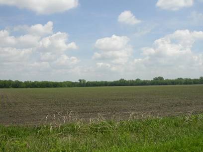
Figure 1. View northeast from E1550 Road. The Wakarusa River wooded buffer area surrounds the property on the north. |
|
|
|
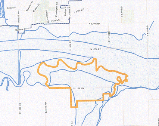
Figure 2.
Floodplain and Floodway as shown on the Flood Insurance Rate Map (FIRM).
included in the overlay district with this rezoning to GPI-FP. |