PLANNING COMMISSION REPORT
Regular Agenda – Public Hearing Item
ITEM NO. 6B : A TO OS; .952 ACRES; NE CORNER OF E 1700 & N 1300 ROADS (MKM)
Z-07-14-07: A request to rezone a tract of land approximately .952 acres, from A (Agricultural) to OS (Open Space). The property is located near the NE corner of the intersection of E 1700 & N 1300 Roads. Submitted by Peridian Group, Inc, for the City of Lawrence, property owner of record.
|
STAFF RECOMMENDATION: Staff recommends approval of the rezoning request for .952 acres from A (Agricultural) District to OS (Open Space) District and forwarding it to the City Commission with a recommendation for approval based on the findings of fact found in the body of the staff report and subject to the following condition: 1. Recording of a final plat prior to publication of the rezoning ordinance |
Applicant’s reason for request: “Rezoning to accommodate a lift station for the City.”
KEY POINTS
· The intent of the applicant is to rezone the site to OS to permit development of a pump, or lift, station.
· The City’s 2003 Wastewater Master Plan recommends a pump station in this area.
· The property lies outside the city limits, in Service Area 1 of the Urban Growth Area. An annexation request was submitted concurrently with this rezoning request and is also being considered at the August Planning Commission meeting.
GOLDEN FACTORS TO CONSIDER
CHARACTER OF THE AREA
· The site is used for agricultural purposes and has never been developed. The property is not encumbered with floodplain or floodway. The property lies near the intersection of two roads, E 1700 and N 1300 which are shown on the Major Thoroughfares Map as a major collector and an arterial, respectively. These roads are currently graveled roads. This is a rural, agricultural area with few scattered rural residences.
CONFORMANCE WITH HORIZON 2020
§ The proposed rezoning request from A (Agricultural) District to OS (Open Space) District is consistent with land use recommendations found in Horizon 2020.
ASSOCIATED CASES/OTHER ACTION REQUIRED
· Annexation request [A-07-06-07]; on the August Planning Commission agenda.
· Preliminary Plat [PP-07-08-07]; on the August Planning Commission agenda.
· Board of County Commissioners finding that the annexation will not hinder the orderly growth and development of the community.
· City Commission approval of annexation and publication of ordinance.
· City Commission approval of the rezoning request and publication of ordinance.
· City Commission acceptance of easements and road right-of-ways as shown on the preliminary plat.
· Final plat submittal for administrative review/approval and recordation at the Douglas County Register of Deeds.
· Special Use Permit for the pump station must be considered by the Planning Commission and approved by the City Commission before being released for building permits.
PUBLIC COMMENT RECEIVED PRIOR TO PRINTING
· None.
GENERAL INFORMATION
|
Current Zoning and Land Use:
Surrounding Zoning and Land Use: |
A (Agricultural) District; Grassland
To the west: A (Agricultural) District; E 1700 Road, Agricultural uses and rural residence.
To the south: A (Agricultural) District; Agricultural uses.
To the east: A (Agricultural) District; Grassland, east of the City owned property is a topsoil removal/construction material recycling operation which was approved with a Conditional Use Permit [CUP-1-2-98].
To the north: A (Agricultural) District; Agricultural uses. Agricultural uses and large lot rural residences.
|
I. ZONING AND LAND USES OF SURROUNDING PROPERTIES
Staff Finding -- The subject property and the surrounding area are zoned A (Agricultural) and agriculture and scattered rural residences are the predominate land use in the area. The subject property is located on the western edge of a 39 acre property owned by the City which is designated as future parkland. The 39 acre property is surrounded on all sides by agriculturally zoned property. A topsoil removal/construction material recycling operation which has been approved with a Conditional Use Permit [CUP-1-2-98] is located to the east.
II. CHARACTER OF THE AREA
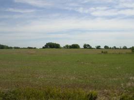
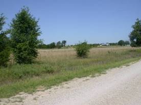
The area is rural in nature with tree-lined gravel roads, agricultural land uses and scattered rural residences. A wooded stream passes diagonally through the area south of the subject property. K-10 is located within a mile to the north with industrially zoned property adjacent to the south right-of-way. This industrial property, located approximately ½ mile to the north of the subject property, includes property within the city limits which is zoned PID (Planned Industrial Development) and property outside the city limits which is zoned I-3 and I-4 (Heavy Industrial) Districts. The County Jail, an asphalt plant, mini-storage facilities, car lot, and excavation company are located in this area. E 1700 Road does not extend on to K-10, but stops at N 1360 Road so the industrial uses do not impact the area in terms of traffic or visibility. (Figures 1 and 2)
Staff Finding -- The area is a rural area with farming activity and scattered rural residences. Industrial uses are located nearby but have little impact on the area.
|
|
|
Figure 1. View of proposed location from E 1700 Road |
|
|
|
Figure 2. View from proposed location across E 1700 Road. |
III. SUITABILITY OF SUBJECT PROPERTY FOR THE USES TO WHICH IT HAS BEEN RESTRICTED
Applicant’s Response:
“Future City parkland.”
The property is currently zoned A (Agricultural) and is located within a larger property which has been purchased by the City and designated as future parkland. According to the County Zoning Regulations the primary purpose of the Agricultural District is to provide for a full range of agricultural activities and to offer protection to agricultural land from the depreciating effect of objectionable, hazardous and unsightly uses. The zoning classifications are currently appropriate for the property as it is county property and is currently being used for agricultural purposes.
A request has been submitted for the annexation of the property into the City of Lawrence. Rezoning to City Zoning Districts is required with annexation and the applicant is requesting a rezoning to the OS District. Per the Development Code, the OS District is intended to preserve and enhance major open space and recreational areas by protecting the natural amenities they possess and by accommodating development that is compatible with those natural amenities. A minor utility is a permitted use in the OS District, but requires a Special Use Permit if it serves more than one specific development.
Horizon 2020 recommends the adoption and implementation of a utility extension policy for Lawrence to guide the sequencing of appropriate future development areas within the UGA. (page 10-11, Horizon 2020). The proposed pump station site was selected based on recommendations from the City’s 2003 Wastewater Master Plan. The pump station is shown in this approximate location on the Relief Improvements Map in Figure IV-1 of the adopted Wastewater Master Plan.
Staff Finding -- The property as zoned would allow for agricultural uses and farm residences. This is a suitable use for this property; however the City 2003 Wastewater Master Plan recommends that a pump station be developed in this area. Upon annexation, the County zoning is no longer applicable. The pump station is a permitted use in the Open Space District with the approval of a Special Use Permit.
IV. LENGTH OF TIME SUBJECT PROPERTY HAS REMAINED VACANT AS ZONED
Applicant’s Response:
“Forever.”
Staff Finding – The property has never been developed but has been used for agricultural purposes.
V. EXTENT TO WHICH REMOVAL OF RESTRICTIONS WILL DETRIMENTALLY AFFECT NEARBY PROPERTY
Applicant’s response:
“It will have no impact.”
The pump station will be unmanned and will generate very little traffic. The City Utilities Engineer indicated that the pump station and wetwell will be enclosed to minimize odors. The station will also be equipped with a chemical feed system to help mitigate any odors produced. The majority of the pumping and mechanical equipment is located inside the structures and noise is minimal. There will be an air-conditioning unit with a typical outside component. There will also be an engine drive generator for backup power in the event electrical power is lost, which will be muffled. This will run intermittently for testing and would run if normal electrical power was lost. There will be regular day time activities by staff for maintenance and operations.
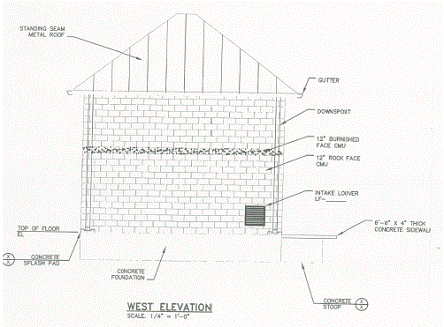
This use will have a minimal impact on the surrounding properties; however, the industrial appearance of the site may detract from the rural character of the area. The pump station’s industrial appearance will be minimized as it is being designed with a peaked roof and stone walls. (Figure 3) Screening will be required from E 1700 Road and the adjacent land to the west as part of the Special Use Permit. The development’s impact on surrounding property owners to the north, east and south will be minimized as the pump station will be buffered by the City owned property which is planned for future parkland. The pump station may have a negative visual impact on the surrounding parkland. The City Parks and Recreation Department have recommended that trees be planted as screening with this phase of the development so they will be established when the property becomes a park. Screening of the facility from the surrounding properties will be a requirement of the Special Use Permit.
The exterior lighting proposed for the facility will be required to be shielded away from surrounding properties.
Staff Finding –Negative impacts associated with the development should be minimal, as the facility is unmanned and is designed to produce very little noise or odor. Screening from the roadway and from the surrounding property will be required with the site plan/Special Use Permit to minimize any negative visual impact.
|
|
|
Figure 3. Conceptual plan with view of the proposed facility from E 1700 Road. |
VI. RELATIVE GAIN TO THE PUBLIC HEALTH, SAFETY AND WELFARE BY THE DESTRUCTION OF THE VALUE OF THE PETITIONER’S PROPERTY AS COMPARED TO THE HARDSHIP IMPOSED UPON THE INDIVIDUAL LANDOWNERS
Applicant’s Response:
“It is a public improvement to aid in the City’s growth.”
Evaluation of these criteria includes weighing the benefits to the public versus the benefits of the owner of the subject property. Benefits are measured based on the anticipated impacts of the rezoning request on the public health, safety and welfare. The pump station is a minor utility which will benefit the City as a whole by accommodating growth in the southeast area. It will also provide for the consolidation of services by the elimination of 3 existing pump stations.
If the rezoning were denied, future growth in the southeast area of the City would be restricted by the existing sanitary sewer capacity.
Staff Finding – The rezoning will have positive public impact by providing a utility service to accommodate future growth in the southeast area and allowing the consolidation of utility services. If the rezoning were denied, future growth would be restricted in the southeastern area.
VII. CONFORMANCE WITH THE COMPREHENSIVE PLAN
Applicant’s Response:
“The land is City parkland.”
The Lawrence Future Land Use Map in Horizon 2020 (page 3-4) shows this property in Service Area 1 and recommends industrial and mixed uses in this area. The subject property is shown as future parkland on the Urban Growth Area and Potential Future Park Zones for Lawrence, Kansas Map, Map 9-1 in Horizon 2020 (page 9-25)
Following are sections of Horizon 2020 that relate to this development:
Community Facilities: Public Utilities Strategies (page 10-11) states that the adoption and implementation of a utility extension policy for Lawrence will guide the sequencing of appropriate future development areas within the UGA. The City’s 2003 Wastewater Master Plan recommends a pump station in this location. The City Utilities Engineer indicated the pump station would accommodate growth in the southeastern area.
Community Facilities: Policy 2.4: Utilize Locational Criteria for Utility Structures: Choose locations and design sites in a manner which minimizes the impact on adjacent properties. Public uses that are potential nuisances should be buffered by screening, distance and/or landscaping. The pump station is being located on City owned land and buffering/screening will be required with the site plan to minimize the impact on adjacent properties.
Staff Finding -- The proposed rezoning request conforms with several Horizon 2020 policies related to community facilities/public utilities.
STAFF REVIEW
The subject property is located within Service Area 1 of the Urban Growth Area, a little less than one mile south of the City limits. The property, and the surrounding area, is zoned for agricultural uses and agricultural uses and rural residences are the predominate land use. There is industrially zoned land approximately ½ mile north of the subject property and industrial uses have been permitted on the property to the east with a Conditional Use Permit. The character of the area is currently rural/agricultural although the Urban Growth Area and Future Land Use Plan shows the area with industrial and mixed uses. The facility must be designed to be compatible with the surrounding rural area.
The proposal is to build a pump station, a minor utility, at this location. The location is in compliance with the City’s 2003 Wastewater Master Plan.
The Use Table in Section 20-403 of the Development Code lists minor utilities as a permitted use in all zoning districts subject to the provision in Section 20-530 which states that a minor utility that serves a specific development would require a site plan while all others require Special Use Permit approval. As this pump station will serve the southeastern area of Lawrence, it will require a Special Use Permit which will include a site plan. Minor utilities in the GPI (General Public and Institutional) District require a minimum site area of 5 acres. As the subject property is located within a future city park it would not be appropriate to remove 5 acres from the parkland when only 1 acre is needed to accommodate the utility. Since the surrounding property will be zoned OS (Open Space) when the parkland is annexed into the City, the OS Zoning Classification was deemed appropriate for this utility. It will be necessary to provide adequate screening of the facility from the surrounding parkland. The Development Code does not set bufferyard requirements for properties that are adjacent to Open Space Zoning Districts; however, as this property encroaches into the parkland, adequate buffering will be provided as recommended by Horizon 2020. The Parks and Recreation Department have recommended that trees be planted during the construction phase of the pump station. Screening must also be provided to minimize the impact on the adjacent roadway and the lands to the west. The buffer/screening will be determined as part of the site planning phase of the Special Use Permit.