|
PLANNING COMMISSION REPORT Non-Public Hearing Item |
PC Staff Report
05/23/07
ITEM NO. 8D: PRELIMINARY PLAT FOR THE CITY WATER RECLAMATION FACILITY; N 1175 RD & E 1600 RD (MKM)
PP-04-04-07: Preliminary Plat for the City of Lawrence Water Reclamation Facility, located at N 1175 Road & E 1600 Road. Submitted by Bartlett & West Engineers, for the City of Lawrence, property owner of record.
|
STAFF RECOMMENDATION: Staff recommends approval of the Preliminary Plat for Wakarusa Water Reclamation Facility Addition and forwarding to the City Commission for acceptance of right-of-way and easements, subject to the following conditions: 1) Submittal of a revised preliminary plat with the following changes: a. All roads labeled with existing right-of-way and right-of-way being dedicated with this plat shown. 15’ of right of way must be dedicated for N 1175 Road (7’ must be dedicated for the 500’ section of the road located 500’ to the east of E 1550 Road and an additional 2’ of right-of-way for E 1600 Road. b. Utility easements must be shown on the plan or a note must be added to the plan stating that the location of the easements will be determined during the design phase of the project and the easements will be shown on the final plat for recording or will be recorded via separate instrument and shown on the site plan. c. Topography must be shown on the plan with contour lines at an interval not greater than 5’ based on an actual field survey performed within the last 12 months and tied to the vertical control benchmarks included with the description. d. Areas designated floodplain or floodway must be shown and labeled on the plat along with surface elevation of the regulatory flood. e. The location and direction of flow of existing water courses must be shown and labeled Wakarusa River or Coal Creek. The waterways must be distinguished graphically from the property line. f. Each zoning category must be delineated with acreage. g. Boundaries of significant stands of mature trees must be shown. The wooded corridor along the Wakarusa River and Coal Creek must be shown on the plat, with dimension, as well as the stand of trees in the southeast portion of the property. If any of these features are to be removed, please note on the plat. h. Statement on the face of the plat noting the method to be used for financing public improvements in the subdivision and providing references to statutes, covenants or other sources for further information on the details of such financing. i. Note on the plat stating that the minimum maintenance designation will be reversed for the portions of N 1175 and E 1600 which are not being vacated if they are to be utilized for access. 2) Public improvement plans for the extension of utilities must be submitted prior to the recording of the final plat. |
|
Reason for Request: |
To create a platted lot so that property may be rezoned and developed with a water reclamation facility.
|
|
SUBDIVISION CITATIONS TO CONSIDER
|
|
|
ASSOCIATED CASES/OTHER ACTION REQUIRED · A-04-02-07; Annexation of this property, also being considered at the May 23rd Planning Commission meeting. · Z-04-04-07; Rezoning this property from V-C and A to GPI, also being considered at the May 23rd Planning Commission meeting. · SUP-04-4-07; Institutional Development Plan through SUP approval, also being considered at the May 23rd Planning Commission meeting. · City Commission acceptance of dedication of easements and rights-of-way.
· Administrative review, approval and recording of a final plat. · Publication of the annexation and zoning ordinances. · Submittal and administrative approval of site plan and floodplain development permit for each phase of the development in accordance with the Institutional Development Plan. · City/County Staff’s determination of dedicated truck route and establishment of maintenance responsibility. · NPDES permit from the Kansas Department of Health and Environment. · Purchase of remaining easements for sanitary sewer lines running to the facility. · Reversal of Minimum Maintenance Road designation for N 1175 and E 1600 Roads if they are to be utilized for access.
|
|
|
PUBLIC COMMENT RECEIVED PRIOR TO PRINTING
|
|
|
GENERAL INFORMATION Current Zoning and Land Use: V-C (Valley Channel) and A (Agricultural) Districts and Floodplain Overlay District; Agricultural uses, and wooded stream corridors.
|
|
Surrounding Zoning and Land Use: To the west: A (Agricultural) and V-C (Valley Channel) Districts and Floodplain Overlay District; Agricultural uses and scattered rural residences.
To the south: A (Agricultural) District and V-C (Valley Channel) District and Floodplain Overlay District; Agricultural uses and scattered rural residences.
To the east: A (Agricultural) District and Floodplain Overlay District; Agricultural uses, wooded areas and scattered rural residences.
To the north: V-C (Valley Channel) District and Floodplain Overlay District; Wakarusa River and agricultural uses. Property to the north is within the floodplain overlay district.
|
Site Summary (as per Section 20-812(a)(4))
Number of Lots: 1
Gross Acres in Subdivision: 536.88 acres
STAFF REVIEW
The subject property is located northeast of the intersection of E 1550 Road and N 1100 Road. No through roads pass through the area which is bounded on the north by the Wakarusa River and the east by Coal Creek. This application is associated with Z-04-04-07, which proposes to rezone the site from V-C (Valley Channel) and A (Agricultural) Districts to GPI (General Public and Institutional). The rezoning is being requested so that the site may be developed with a water reclamation facility. The City’s Wastewater Master Plan indicated the need for an additional reclamation facility and recommended a location south of the Wakarusa River. This particular site was chosen because its isolated location would minimize impacts on neighboring residents and it will not be affected by any of the proposed South Lawrence Trafficway Alignments. This application is being reviewed under the Subdivision Regulations for Lawrence and Unincorporated Douglas County, which took effect January 1, 2007.
Zoning and Land Use
The subject property, shown as Lot 1 on the preliminary plat, is undeveloped. The property consists primarily of V-C (Valley Channel) zoning with a small portion of A (Agricultural). The plat must be revised to show the areas in each zoning district.
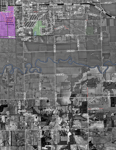
The property is relatively isolated and located in an area with sparse residential development. The location of the property will minimize any negative impacts, such as odor, on neighboring properties. (Figure 1.)
Right-of-Way & Access
The property will have direct access to a public street/road. The subject property is currently accessed by N 1175 and E 1600 Roads, which are both minimum maintenance roads. The portions of these roads which are located within the subject property are being vacated. The minimum maintenance designation for the remainder of the roads will be reversed if they are to be utilized for access.
The Development Code requires that a GPI site take access from a major collector or arterial [Section 20-218(e)]. While the road must be of suitable construction to handle the anticipated truck traffic, this particular use is not suitable for location on a ‘high traffic’ road or a road with a high degree of development around it. Other GPI uses which would be appropriate for location on a collector or arterial road would be schools, colleges, civic buildings, and recreational facilities. A water reclamation facility would neither require nor be suitable for location along a collector or arterial. Horizon 2020 recommends isolating and buffering the facility to minimize negative impacts (policy 2.4(c), page 10-17). Staff recommends that the facility be allowed to locate on a road that is not classified as an arterial or major collector because the nature of the project would not be an appropriate use for a highly traveled road, or the type of development associated with these road classifications.
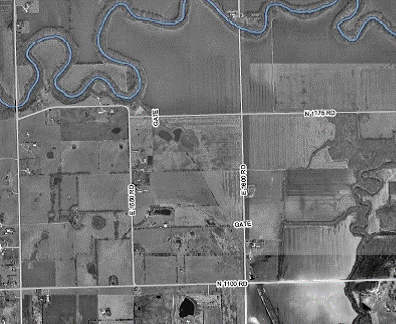
Additional right-of-way will be dedicated for the roads adjacent to the property. E 1600 Roads has a 66’ right-of-way and N 1175 has a 56’ right of way for a 500’ section about 500’ east of E 1550 Rd and a 40’ right-of-way for the remainder. (Figure 2.) Both roads are local roads which require 70’ of right-of-way. The Douglas County Public Works Director indicated the following right of way must be dedicated:
- 7’ additional right-of-way must be dedicated for the 500’ portion east of E 1550 Road
- 15’ of right of way must be dedicated for remainder of N 1175 Road, and
- an additional 2’ of right-of-way for E 1600 Road.
Roads must be shown along with existing right-of-way and right-of-way being dedicated with this plat.
Infrastructure
The subject site does not currently have access to water infrastructure. City water lines do extend into the area, south along E 1500 Road, to access the City of Baldwin Main. Lines may be extended east from this line along N 1100 Road to serve the facility. The Utility Department is also considering extending a water main from the north across the Wakarusa River to this facility. There are several options for the extension of water service to the area, but the final determination will be made at the design/build phase of the project.
The subject site will provide sanitary sewer service. Sanitary sewer mains are being planned through corridors to access the site. As much as possible, the lines are being placed in road rights-of-way and easements to minimize impact on area property owners and easements are being purchased where locating in the right-of-way is not feasible.
Easements
Section 810(f)(1) of the Subdivision Regulations requires that utility easements must be provided for the facility and must be shown on the plan. Easements may be shown on the preliminary plat, but they are conceptual at this phase. There are no utilities existing in this area which must be extended through the property. The actual location of the easements will be determined when the project is designed and the easements will either be shown on the final plat, or dedicated by separate instrument and shown on the site plans being submitted with each phase.
Staff Review
The preliminary plat must be revised to meet the requirements listed in Section 20-812 of the Subdivision Regulations. Topography must be shown on the plan with contour lines at an interval not greater than 5’ based on an actual field survey performed within the last 12 months and tied to the vertical control benchmarks included with the description. Areas designated floodplain or floodway must be shown and labeled on the plat along with surface elevation of the regulatory flood. The location and direction of flow of existing water courses must also be shown. Boundaries of significant stands of mature trees must be shown. Designation of Wakarusa River and Coal Creek should incorporate graphic feature, such as hatch marks or different weighted line, to distinguish from other property lines. The wooded corridor along the Wakarusa River and Coal Creek must be shown on the plat, with dimension, as well as the stand of trees in the southeast portion of the property. If these features are to be removed, they should be noted on the plan. A site summary table must be included on the plat with the gross acreage of the subdivision, acreage within each zoning district, and acreage to be dedicated for additional road right-of-way. Public improvement plans must be submitted before the final plat can be recorded. Section 20-812(a)(4)(ii) requires a statement on the face of the plat stating the method to be used for financing public improvements in the subdivision and providing references to statutes, covenants or other sources for further information on the details of such financing.
Conformance
The lot in the proposed plat meets the density and dimensional standards for lots in the GPI zoning district. The access being proposed for the development will be local roads rather than collector or arterials, but it has been determined that this type of use would be best located away from major roads and development area. The preliminary plat conforms to the Subdivision Regulations, Density and Dimensional Standards of the Development Code, and Horizon 2020.
|
|
|
Figure 1. Wakarusa Water Reclamation Facility Site (in blue) with area roads shown in red. |


|
Figure 2. Illustration of existing road rights-of-way for N 1175 and E 1600 Roads. |

|
|