PLANNING COMMISSION REPORT
Regular Agenda – Public Hearing Item
PC Staff Report
07-25-07
ITEM NO. 6 : RS10 TO RS5; .954 ACRES; 523-543 ROCKLEDGE (MKM)
Z-11-28-06: A request to rezone a tract of land approximately .954 acres, from RS10 (Single-Dwelling Residential) to RS5 (Single-Dwelling Residential). The property is located at 523-543 Rockledge. Submitted by Paul Werner Architects, for LC Anuff, property owner of record. Deferred from the May meeting.
|
STAFF RECOMMENDATION: Staff recommends approval of the approximately .954 acres from RS10 (Single-dwelling Residential) District to RS5 (Single-dwelling Residential) District and forwarding it to the City Commission with a recommendation for approval based on the findings of fact found in the body of the staff report and subject to the following conditions:
1. Staff recommends conditioned zoning with the following conditions: a. Development restricted to 5 lots. b. Additional setbacks required: 25’ front yard setback and 10’ peripheral side yard setback (southern side of lot 1 and northern side of lot 5). c. Building envelopes must be shown on the plat. d. Development restricted to 3 curb cuts onto Rockledge Road. e. 15’ wide street planting yard be provided along Rockledge Road with a planting rate of 3 ornamental or understory trees and 8 shrubs per 100 linear feet. Native grasses, forbs, bushes, and trees should be utilized to minimize maintenance. 1/3 of the plantings shall be evergreen species. 2. Recording of a final plat prior to publication of the rezoning ordinance.
|
Applicant’s reason for request: “The request arises from the desire to provide more appropriate single family residences than what the current property is currently platted and/or planned. Wile our proposal increases the density slightly it is consistent with the adjacent properties in use and addresses the need for a buffer to the commercial property across Rockledge. Our Proposal also addresses a potential increasing problem along Rockledge by minimizing the required curb cuts.”
ATTACHMENTS:
- Attachment A- Public Comment
- Attachment B- Minutes from Dec, 2006 Planning Commission meeting regarding this item.
KEY POINTS
· Property is currently platted with 3 lots. Rezoning to RS5 is being requested to allow the property to be replatted and developed with 5 lots.
· This Rezoning request was considered by the Planning Commission at their December 20th meeting. The rezoning was requested to allow the property to be replatted and developed with 6 lots and the Commission recommended denial of the rezoning request to RS5.
· Applicant requested the City Commission to refer the item back to the Planning Commission for consideration of a revised plan.
· The property was final platted as part of the Country Club Terrace Final Plat; recorded in September of 1935 and has not been developed.
· Two rezonings have been approved recently for the lots on the northeast end of this block (lots 18-21 of Country Club Terrace Subdivision). These rezonings were from RS10 (Single Dwelling Residential) to RMO (Multi-Dwelling Residential-Office) and RSO (Single-Dwelling Residential-Office) Districts.
GOLDEN FACTORS TO CONSIDER
CHARACTER OF THE AREA
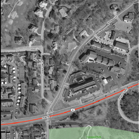
- The property lies approximately 1/8 of a mile north of US Hwy 40/ 6th Street; a major arterial. There are a variety of uses in this area including a golf course, large lot single-family homes, high density apartments, several hotel/motels, auto service facility and professional offices. The area contains a mix of uses with the predominate uses being motels, offices and residences (multi- and single-dwelling). The general area has substantial open space in the form of a private golf course and a 35 acre community park.
CONFORMANCE WITH HORIZON 2020
§ The proposed request conforms to land use recommendations found in Horizon 2020.
ASSOCIATED CASES/OTHER ACTION REQUIRED
· Approval of this rezoning request by the City Commission and Ordinance publication.
· Property must be platted into 5 lots.
· Submittal of Public Improvement Plans before final plat can be recorded.
· Recordation of Final Plat at the Register of Deeds Office.
PUBLIC COMMENT RECEIVED PRIOR TO PRINTING
§ Dick George, adjacent property owner to the north, stopped in the Planning Office to express his opposition to the proposal. He feels that a maximum of 3 lots are appropriate for this area.
§ Dave Kolarik, adjacent property owner to the south, sent a letter to the Planning Office expressing his opposition to the proposed increase in density. He attached a copy of a letter submitted when the item was considered by the Planning Commission in December, 2006 outlining the reasons for his opposition which he provided when this item was originally considered at the Planning Commission. Both letters are attached with this staff report.
GENERAL INFORMATION
|
Current Zoning and Land Use:
Surrounding Zoning and Land Use:
Surrounding Zoning and Land Use(cont.): |
RS10 (Single-dwelling Residential) District; undeveloped land.
RS10 (Single-dwelling Residential) District to the north; single family homes and Lawrence Country Club with golf course.
RSO and RMO (Single-dwelling Residential-office and Multi-dwelling Residential-office) Districts to the northeast along Rockledge Road; residences and vacant land with an approved site plan for a professional office building.
RS10 (Single-dwelling Residential) District to the west; large lot single family homes.
CS (Commercial Strip) District to the east; motels and apartments.
RS10 (Single-dwelling Residential) and CS (Commercial Strip) District to the south; single-family homes and motel.
|
I. ZONING AND LAND USES OF SURROUNDING PROPERTIES
Staff Finding -- The surrounding properties are zoned RS10 (Single-dwelling Residential) and CS (Commercial Strip) Districts. Single-family residences located on large lots and combined lots are located in the RS10 District and motels and an apartment complex is located in the CS District.
II. CHARACTER OF THE AREA
This area is bounded on the east by US Hwy 59/McDonald Drive and on the south by US Hwy 40/W 6th Street. Several land uses converge in this area. Large lot, single family homes are located in the RS10 Zoning District bordering the Lawrence Country Club Golf Course and a ‘peninsula’ of RS10 Zoning with single-family homes extends south along Rockledge Road and Country Club Terrace to W 6th Street.
A node of development including motels, an apartment complex, offices and vehicle service station is located at the intersection of Hwy 59/McDonald Drive and Hwy 40/W 6th Street. Development along W 6th Street to the west includes apartment complexes, offices, multi-family dwellings, motels, and commercial uses. Land uses within an approximately 1/8 mile radius of the subject property include single-dwelling residences, office/residential, apartments, motels, offices, auto service and repair, and green space.
Staff Finding -- This is a high activity area, being located just to the northwest of a major arterial intersection (Hwy 40/6th Street and Iowa Street). Land uses are separated by Rockledge Road with low-density residential uses to the west and commercial uses to the east. There is quite a bit of development in the area balanced with a large amount of open space.
III. SUITABILITY OF SUBJECT PROPERTY FOR THE USES TO WHICH IT HAS BEEN RESTRICTED
Applicant’s Response:
“The property is unique in that as Rockledge runs to the Northeast the property gets deeper. Therefore the current lots are fairly large, in fact existing Lot 15 is almost half an acre. While it seems single family residences are appropriate due the adjacent properties, the current configuration is not. The current configuration does not help minimize potential curb cuts, which as Rockledge’s uses has increased, this has a potential for creating traffic issues. For these reasons it does not seem the current configuration of the property is appropriate.”
The purpose of the RS Districts is to accommodate predominantly single-dwelling detached units on individual lots. The districts are intended to create, maintain and promote housing opportunities for individual households. The differentiation between the different RS Zoning Districts is the size of the lots allowed. The RS10 requires a minimum lot size of 10,000 sq. ft. while the RS5 requires a minimum lot size of 5,000 sq. ft. The requested zoning change would not alter the type of use merely the lot size and, consequently, the density.
Staff Finding -- The site is suitable for single-dwelling residential uses; however, smaller lots may be preferable given the intensity of use on adjacent properties.
IV. LENGTH OF TIME SUBJECT PROPERTY HAS REMAINED VACANT AS ZONED
Applicant’s Response:
“There has never been any development associated with this property.”
Staff Finding – The property was platted in 1935 and has been zoned for single-family residential since that time; although the zoning classifications have changed with the adoption of the 1966 Zoning Ordinance and the 2006 Development Code. The property has never been developed.
V. EXTENT TO WHICH REMOVAL OF RESTRICTIONS WILL DETRIMENTALLY AFFECT NEARBY PROPERTY
Applicant’s response:
“The request will not detrimentally affect the nearby properties. In fact this development will enforce the current zoning of single family homes, at a slightly increased density. I feel it is more important to be consistent with the single family use as opposed to other uses which may be proposed along this street, due to its higher traffic volume and the commercial uses across the street.”
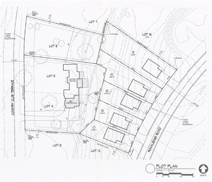
This rezoning request is for Lots 13, 14, and 15 of the Country Club Terrace Subdivision. These lots are not addressed as they are vacant, but are located between 545 and 521 Rockledge Road. The property to the east, across Rockledge Road, is zoned CS (Commercial Strip) District and is occupied by motels, an apartment complex and professional offices. The adjacent properties to the north, west and south are zoned RS10 for Single-dwelling Residential. There is residential-office zoning 2 lots to the north of the subject property on Rockledge Road. The lot at the corner of McDonald Drive and Rockledge Road, 501 Rockledge Road, is zoned RMO (Multi-dwelling Residential-office) District and a site plan has been approved for a professional office building at this location. The adjacent lots to the south, 505 and 515 Rockledge Road, are zoned RSO (Single-dwelling Residential-office) District. (Figure 1.)
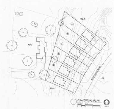
The concept plan submitted with the rezoning request contains shared access points between lots 1 & 2 and between lots 3 & 4 and a single driveway for lot 5 resulting in 3 curb cuts onto Rockledge Road. The shared access points will result in the same number of curb cuts that would be permitted with the RS10 zoning. Shared access points will result in more greenspace along Rockledge Road than if each unit were to have its individual curb cut. The applicant should be aware that Section 20-908(b)(3) of the Development Code permits a maximum driveway width in the RS5 District of 12’ to reduce pavement width and maintain the character of the neighborhood. The concept plan provided with the rezoning was not drawn to scale, but when platting the property the plan must show that each individual driveway is not more than 12’ wide.
The property is located in an area with a variety of uses. Rezoning to a medium density residential use would allow a buffering area while retaining the residential character. RS5 zoning permits single-dwelling residences on smaller lots than the RS10 zoning. The rezoning would allow 6 houses to be built, where only 3 are possible today. Based on Planning Commissioner’s comments and public comment made at the December Planning Commission meeting, the applicant has revised the plan to allow for 5 lots rather than the 6 previously requested.
Several neighbors opposed increase in density at the December Planning Commission meeting. The applicant has revised the development plan to provide 5 lots rather than 6, as in the previous proposal. (Figure 2)
Staff Finding – The rezoning would allow 5 residences to be constructed rather than the 3 residences permitted under the existing zoning. The additional residences would increase the traffic volume on Rockledge Road. However, Rockledge Road is classified as a ‘minor arterial’ street so it is expected that the impact of the additional traffic from the 2 additional residences would be slight.
VI. RELATIVE GAIN TO THE PUBLIC HEALTH, SAFETY AND WELFARE BY THE DESTRUCTION OF THE VALUE OF THE PETITIONER’S PROPERTY AS COMPARED TO THE HARDSHIP IMPOSED UPON THE INDIVIDUAL LANDOWNERS
Applicant’s Response:
“There is gain to the general public in several ways. By approving the proposed development the owner will provide single family residences, however their access will be limited to two points along Rockledge. This will better serve the proposed residents as well as the general public who use Rockledge everyday.
The construction of single family homes will complete a portion of Rockledge which is currently in transition. Since there are single family homes on both sides we feel that is the appropriate use, however there is an argument for more intense uses, which may be appropriate, but not as desirable for the adjacent properties. Slightly more dense single family homes seem to provide an appropriate use for the subject property.”
Evaluation of this criterion involves comparing the effect of the denial of the application; both the gain, if any, to the community and the hardships imposed upon the landowner. Benefits are measured based on the anticipated impacts of the rezoning request on the public health, safety and welfare.
The denial of the rezoning would prohibit smaller lots in this area and maintain the 3 platted lots as opposed to the 5 proposed. Upon development, the residences in this area would have the same setbacks and similar lot sizes as the neighboring properties, which would help maintain the character of the neighborhood.
This property has been platted as 3 lots and zoned for single-family residence since 1935 but has not been developed with residences to this time. The intensity of commercial and residential/office uses in the nearby area may act as deterrents to the development of large-lot, low density, single family homes. If development of 3 large lots in this area is not feasible, the property would remain vacant.
Staff Finding – Denial of this rezoning request might benefit the community by maintaining the character of the neighborhood by keeping the density the same. The hardship to the landowner is that, as the land has remained undeveloped since 1935, it is likely that the properties could not be developed and sold as low density residential properties as zoned.
VII. CONFORMANCE WITH THE COMPREHENSIVE PLAN
Applicant’s Response:
“The request conforms with the Horizon 2020 as proposed for several reasons. The proposal is consistent with the current adjacent uses, single family homes. While the proposal does increase the density slightly, the proposed zoning is still classified as low-med density, which is the identified land use for this area. The RS5 actually helps with the lot widths more than the actual density. The average lot size is just under the RS7 zoning district with is classified as low density, which is consistent with this area and Horizon 2020.
The ability to combine and minimize curb cuts is predominant goal throughout H2020. The ability to do this is helped by the slight increase of density along this stretch of Rockledge and therefore should be seen as beneficial to the neighboring properties and the city in general.”
Horizon 2020 defines ‘low density’ as 6 or fewer dwelling units per acre [7,260 sq ft per residence or more] and ‘medium density as 7 to 15 dwelling units per acre [2,904 sq ft to 6,223 sq ft per residence]. The existing RS10 zoning is ‘low density’ and the proposed RS5 zoning is ‘medium density’. This proposal would serve as both transitional land use and as infill development.
Horizon 2020 recommends that medium-density residential development occupy transitional locations between single-family neighborhoods and office/commercial areas. “In addition to providing attractive new housing options within the city, these areas should be designed to help avoid major and abrupt changes in density or use.” Page 5-4
Goal 3: Policy 3.2 Medium-Density Residential Development as Transitional Use.
“Encourage the integration of medium-density residential development through compatible design with low-density residential areas and more intensive land uses.”
The medium density development would serve as a transition between the RS10 development adjacent to the west and the more intensive land uses in the CS District to the east.
GOAL 3: Policy 3.1 Use Appropriate Transitional Methods
3.1(c)(2)(b) “More intensive residential uses should have perimeter setbacks that are equal to or greater than the perimeter setbacks of the abutting low-density residential uses.”
The RS5 Zoning District requires 5’ side yard setbacks, while the RS10 District requires 10; therefore, the zoning would be conditioned with a requirement for greater perimeter setbacks. The perimeter setback (side yard setback for the southern side of Lot 1 and the northern side of Lot 5) must be 10’ as recommended in policy 2.4 and 3.1. If the lots are too narrow to accommodate the 10’ side yard setbacks, a smaller setback may be possible on the opposite side yard through an exception listed in Section 20-601(e)(3)(ii) of the Development Code.
3.1(c)(2)(c) “Where medium-density development adjoins or is across the street/road from a low-density residential area, the medium-density development should be designed to maintain or continue the visual appearance of the street/roadscape through building massing, height and orientation of structures.”
The orientation of the buildings and the additional front yard setbacks will help maintain the streetscape appearance.
Goal 3: Policy 3.3 Encourage Compatible Infill Development
a) “Encourage redevelopment and infill as a means of providing a variety of compatible housing types within neighborhoods.”
Strategies for residential development listed on page 5-1 of Horizon 2020 include:
“A mixture of housing types, styles and economic levels should be encouraged for new residential and infill developments.”
“The character and appearance of existing residential neighborhoods should be protected and enhanced. Infill development, rehabilitation or reconstruction should reflect architectural qualities and styles of existing neighborhoods.”
The comprehensive plan recommends that infill development should conform to lot size, housing type, scale and general architectural style of the area in which it is proposed. (Policy 3.3; page 5-15)
Horizon 2020 recommends the following principles to maintain the form and pattern of established neighborhoods (page 5-16):
1. Building orientation should reflect the predominant neighborhood pattern and existing streetscape.
Buildings will be oriented toward Rockledge Road and will be consistent with the existing pattern.
2. Continuity of vehicular and pedestrian circulation patterns should be considered.
Shared access, allowing a maximum of 3 curb cuts onto Rockledge Road, would maintain the vehicular patterns.
3. Open space patterns and front, side and rear yards characteristic of the neighborhood should be maintained.
The rear yard setbacks are the same for both districts. Staff is recommending a required front yard setback of 25’, in keeping with the other lots in on Rockledge and a perimeter side yard setback of 10’ on the south side of Lot 1 and the north side of Lot 5. This would maintain the front and rear yards characteristic of the neighborhood and maintain the characteristic side yards as much as possible with the narrower lots.
The perimeter side yard setbacks could be landscaped to screen the higher density properties. A partial screening would be recommended as it is important that the development be compatible with the existing development rather than being set apart.
4. Building height should be compatible with the average height of homes in the neighborhood, especially adjacent residences.
The adjacent residences are split-level to the south, and single story to the north. Code does not provide the regulatory tools necessary to regulate housing styles.
Goal 2: Create a Functional and Aesthetic Living Environment
Policy 2.3 Provide for Extra Screening in Special Circumstances
b. “Encourage subdivision design which provides additional buffering between homes and adjacent arterial street/roads.”
Rockledge Road is classified as an arterial road, therefore additional landscaping would buffer the property from the arterial road as recommended by Horizon 2020 and would also buffer the development from the intensive land uses across Rockledge Road. Staff recommends a 15’ wide street planting yard be provided along Rockledge Road with a planting rate of 3 ornamental or understory trees and 8 shrubs per 100 linear feet. Native grasses, forbs, bushes, and trees should be utilized to minimize maintenance. 1/3 of the plantings shall be evergreen species.
Policy 2.4 Provide Open Space
a. “Encourage the provision of useable open space on site by clustering buildings to minimize the creation of narrow, marginal-use areas in front of and between buildings.”
The concept plan shows the houses on lots 1 & 2 and 3 & 4 being located nearer the adjacent property lines between the lots. This will accommodate the shared access points and also create larger open space on the exterior sides of the lots.
Staff Finding -- The proposed rezoning is in conformance with Horizon 2020 as an Infill/Transitional use. It is important that the development be designed to provide effective transition and also to maintain the neighborhood character along Rockledge Road. Care must be taken to ensure that this development is compatible with the nearby residential properties; especially given the increase in density which is required for the transition. Conditioned zoning is recommended to achieve compatible design.
STAFF REVIEW
The Planning Commission considered this rezoning request at their December 20th meeting. Several members of the public spoke at the meeting in opposition to the plan based on the increased density and the negative impact they felt it would have on their neighborhood. The Planning Commission considered rezoning the property to RS7 using the lesser change table which would have permitted 4 lots. The applicant indicated that a less dense development may be possible, but felt that developing the property with 4 lots would be problematic and requested that the rezoning to RS7 not be pursued. The Planning Commission then voted to recommend denial of the rezoning request based primarily on the increase in density and neighborhood concerns. The applicant revised their concept plan and requested the City Commission return the item to the Planning Commission for reconsideration. The City Commission voted to return the item to the Planning Commission for reconsideration at their February 13, 2007 meeting. The revised plan has reduced the density with 5 lots being proposed rather than the original 6. The lot to the west was recently reconfigured through a lot split so the lots directly to the east will be shallower (Lots 1, 2, and 3 of the concept plan) which resulted in 5 lots of varying sizes.
Horizon 2020 recommends using medium-density residential development (7 to 15 units per acre) as transitions from more intensive land uses. The aerial in figure one illustrates the land uses in the area. The proposed density is in keeping with the recommendations of Horizon 2020. The proposed increase in density may provide a more ‘mixed’ neighborhood in lot sizes and perhaps a variety in home types as is recommended in Horizon 2020 for infill or transition development.
The conditions recommended for this rezoning will result in a more compatible development. Integration with the neighborhood is one of the criteria for applying conditioned zoning. Staff recommends approval of this zoning request with conditioned zoning. If the Commission prefers to approve the rezoning without the conditions, it should be stated in the minutes that the plat must meet the conditions. Staff recommends conditioning the zoning because it will alert future landowners that there are special setback and landscaping requirements for this property.
|
Figure 1. Aerial showing land use in area of Rockledge rezoning request. (area in blue is the subject property. |

|
|
|
Figure 2. Revised concept plan with 5 lots above, and original concept plan with 6 lots below. |
|
|