20-508 Detached Dwelling
A detached Dwelling shall only be permitted to be constructed in an RM or RMO district, after the Effective Date, by approval of a special use permit. A detached Dwelling may be permitted to be constructed without the approval of a special use permit if it is located on its own platted lot, and if the majority of the properties on the Block Face are constructed as detached Dwellings.
20-524 Restaurant, Quality
(1) Standards that Apply in CN1 and IBP Districts
A quality restaurant is permitted in the CN1 and IBP Districts provided that the gross Floor Area shall not exceed 3,000 square feet.
(2) Standards that Apply in CO District
A quality restaurant is permitted in the CO District provided that the total Floor Area does not exceed 10 percent (10%) of the total gross Floor Area of the office Building or of all Buildings in the office complex in which the use is located.
20-533 General Standards for Accessory Structures
The standards of this subsection apply to all Accessory Uses and Structures.
(1) Time of Construction
Accessory Structures shall be constructed in conjunction with or after the Principal Building. They shall not be built prior to the construction of the Principal Building.
(2) Subordinate Nature
(i) Accessory Uses shall be a subordinate part of a Principal Use and be clearly incidental to a Principal Use.
(ii) Accessory Structures shall be of secondary importance and subordinate in size and scale to the Principal Building on a site.
(3) Density and Dimensional Standards
Unless otherwise expressly stated, the Setback, Height, and Building coverage standards of the Base District apply to both principal and Accessory Structures (See Density and Dimensional Standards, Article 6). Accessory Structures in residential districts shall be located to the rear of the front building line and may be located as close as 5' to interior and rear lot lines. Setbacks from interior side lot lines shall not apply to accessory buildings placed on lots that abut alleys. An accessory structure may be located up to the rear property line when the lot abuts an alley and when the doors to the building do not open directly onto the alley. There shall be no Setback required between an Accessory Structure and an Alley when Access to the Structure is parallel to the Alley, except that no part of the Structure shall overhang or otherwise encroach onto the Alley.
(4) Building Coverage
(i)
The combined footprint of all detached covered Accessory Structures may not exceed the footprint of the Principal Building ,
or 20% of the total area of the Lot, whichever is greater.
(ii)
A detached Accessory Structure may not have a
larger footprint than the Building footprint of the Principal Building.
(i) A detached Accessory Structure may not have a larger footprint than the Building footprint of the Principal Building.
(ii) The combined footprint of all Accessory Structures may be equal to the footprint of the Principal Building or 20% of the Lot Area, provided the total footprint of all structures does not exceed the maximum Building coverage as permitted by Section 20-601(a) or (b) for the corresponding zoning district.
(5) Height of Accessory Structures
Unless otherwise expressly stated, Accessory Structures may not exceed 25 feet in Height, or the Height of the Principal Building on the same Lot, whichever is less.
20-534 Accessory Dwelling Units (permitted only in RS40, RS20, RS10, RS7, and CN1)
(1) Purpose
Accessory Dwelling Units are allowed in certain situations to:
(i) create new housing units while preserving the look and scale of single-Family detached Dwelling neighborhoods; allowed in RS zones, subject to the procedures established in Section (xi) Registration; Affidavit;
(ii) allow more efficient use of the City’s existing housing stock and Infrastructure;
(iii) provide a mix of housing types that responds to changing Family needs and smaller households;
(iv) provide a means for residents, particularly seniors, single parents, and couples, to remain in their homes and neighborhoods, and obtain extra income, security, companionship and services; and
(v) provide a broader range of accessible and more affordable housing.
(2) Design Standards
(i) Purpose
These design standards are intended to ensure that Accessory Dwelling Units:
a. are compatible with the desired character and livability of RS Zoning Districts;
b. respect the general Building scale and placement of Structures to allow sharing of common space on the Lot, such as Driveways and Yards; and
c. are 960 square feet or smaller in size.
(ii) Generally
The design standards for Accessory Dwelling Units are stated in this section. If not addressed in this section, the Base District standards apply.
(iii) Methods of Creation
An Accessory Dwelling Unit may only be created through one of the following methods:
a.
converting existing living area within a Detached
Dwelling, Attached
Dwelling or duplex (e.g., attic, Basement or attached
garage);
b.
adding Floor Area
to an existing Detached Dwelling, Attached Dwelling or duplex, detached garage; or
c.
constructing a new Detached Dwelling, Attached Dwelling, duplex or detached garage with an
internal Accessory Dwelling Unit.
(iv) Owner Occupancy Required in RS Districts
Either the principal Dwelling Unit or the Accessory Dwelling Unit must be occupied by one or more of the persons who is/are the record Owner of the Premises.
If at any time, neither of the Dwelling Units in a Building that contains an Accessory Dwelling Unit is the principal residence of one of the Owner of the property, then the property shall be considered a Duplex. If a Duplex is not permitted in the Zoning District in which the property is located, the Owner shall be subject to penalties for a zoning violation and to an abatement order requiring restoration of the Premises to lawful status, conforming with the uses permitted in the Zoning District.
(v) Number of Residents
The total number of individuals that reside in both units (principal + accessory) may not exceed the number that is allowed for a household, plus one additional person.
(vi) Other Uses
An Accessory Dwelling Unit is prohibited in a house with a Type B Home Occupation.
(vii) Location of Entrances
a. Only one entrance to the Principal Building may be located on the front Facade that faces the Street, unless the Principal Building contained an additional Street-facing entrance before the Accessory Dwelling Unit was created.
b. When the Accessory Dwelling Unit is located behind the rear wall of the Principal Building , the accessory Dwelling entrance shall face the Front Lot Line.
c. An exception to subsection(b), above, is Dwelling Units that do not have Access from the ground such as Dwelling Units with entrances from balconies or elevated decks.
(viii) Parking
The following Parking requirements apply to Accessory Dwelling Units.
a. Lots containing Accessory Dwelling Units shall contain a minimum of two off-Street Parking Spaces.
b. If the Lot containing the Accessory Dwelling Unit abuts only a Local Street and the pavement of the Local Street is at least 27 feet wide, no additional Parking Space is required for the Accessory Dwelling Unit.
c. If the Lot containing the Accessory Dwelling Unit abuts only a Local Street and the pavement of the Local Street is less than 27 feet wide, or if the Accessory Dwelling Unit is created at the same time as the principal Dwelling Unit, one additional Parking Space is required for the Accessory Dwelling Unit.
d. One additional Parking Space is required for the Accessory Dwelling Unit if the Lot containing the Accessory Dwelling Unit abuts only a Collector or Arterial Street.
(ix) Size
The maximum size of an Accessory Dwelling Unit may be no more than (33%) of the living area of the Detached Dwelling or Attached Dwelling, or 960 square feet, whichever is less.
(x) Floor Area Additions
Accessory Dwelling Units created through the addition of habitable Floor Area to an existing Structure shall comply with the following standards:
a. the exterior finish material shall be the same or visually match in type, size and placement, the exterior finish material of the house or existing Structure;
b. the roof pitch shall be the same as the predominant roof pitch of the house or existing Structure;
c. trim on edges of elements on the addition shall be the same in type, size and location as the trim used on the rest of the house or existing Structure;
d. windows shall match those in the house in proportion (relationship of width to Height) and orientation (horizontal or vertical);and
e. eaves shall project from the Building walls the same distance as the eaves on the rest of the house or existing Structure.
(xi) Registration; Affidavit
a. Accessory Dwelling Units shall be registered with the Planning Director prior to their establishment. The requirement for registration is intended to ensure that the applicant is aware of the provisions of this Development Code governing Accessory Dwelling Units; that the City has all information necessary to evaluate whether the Accessory Dwelling Unit initially meets and continues to meet Development Code requirements; and that the distribution and location of Accessory Dwelling Units is known.
b. At the time of registration, the applicant shall submit an affidavit pledging agreement to the Accessory Dwelling Unit standards of this section. The affidavit shall specify which of the Dwelling Units will be occupied by an Owner of the property; if at any time such Owner moves to the other Dwelling Unit, the Owner shall be responsible for filing an updated affidavit, recording such change.
c. Permits for Accessory Dwelling Units may be issued after the Planning Director determines that the proposal complies with all applicable Development Code requirements.
20-537 Home Occupations
Home Occupations are activities accessory to uses in the Household Living category. Special regulations apply to such activities to ensure that Home Occupations will not be a detriment to the character and livability of the surrounding neighborhood. The regulations are intended to ensure that the Home Occupation remains subordinate to the residential use, and that the residential viability of the Dwelling is maintained. The regulations recognize that many types of work can be done in a home with little or no effect on the surrounding neighborhood.
Uses are allowed as Home Occupations only if they comply with all of the requirements of this section.
(3) Exemptions
(i) Day Care Homes
Day Care homes are not regulated as a Home Occupation and are exempt from the Home Occupation regulations of this section.
(ii) Bed and Breakfast and Bed and Breakfast Inns
Bed and Breakfasts and Bed and Breakfast Inns are not regulated as Home Occupations and are exempt from the regulations of this section.
(4) Description of Type A and Type B Home Occupations
There are two types of Home Occupations: Type A Home Occupations and Type B Home Occupations.
(i) Type A
A Type A Home Occupation is one where residents use their home as a place of work, with no employees or customers/clients coming to the site. Examples include artists, crafts people, writers, and consultants.
(ii) Type B
A Type B Home Occupation is one where an employee and/or customers/clients come to the site. Examples are counseling, tutoring, and hair cutting/styling.
(i) Allowed Uses
The intent of the regulations of this section is to establish performance standards for all Home Occupations rather than to limit uses and activities to a specific list. Home Occupations that comply with the performance standards of this section are allowed by-right unless otherwise expressly stated.
(ii) Prohibited Uses
a. Any type of repair or assembly of vehicles or equipment with internal combustion engines (such as autos, motorcycles, scooters, snowmobiles, outboard marine engines, lawn mowers, chain saws, and other small engines) or of large appliances (such as washing machines, dryers, and refrigerators) or any other work related to vehicles and their parts is prohibited.
b. Home Occupations may not serve as headquarters or dispatch centers where employees come to the site and are dispatched to other locations.
c. Funeral and Interment Services are not allowed as Home Occupations.
d. Animal Services are not allowed as Home Occupations.
e. Restaurants are not allowed as Home Occupations; catering for off-premise consumption is not prohibited.
f. A Type B Home Occupation is prohibited on a Lot where an Accessory Dwelling Unit exists.
g. More than two garage sales within a calendar year is a prohibited use.
(i) Signs
One non-animated, non-illuminated, accessory identification sign of no more than 2 square feet in area shall be permitted. The allowed sign shall be placed flat against a wall or door, displayed in a window, or within ten feet (10’) of the Building entrance.
(ii) Outdoor Activities
a. All activities shall be in completely enclosed Structures.
b. Exterior storage or display of goods or equipment is prohibited.
(iii) Appearance
The Dwelling and site shall remain residential in appearance and characteristics. Internal or external changes that will make the Dwelling appear less residential in character or function are prohibited. Examples of such prohibited alterations include construction of Parking Lots, paving of required Setbacks, or the addition of commercial-like exterior lighting.
(i) Hazardous Substances
Hazardous substances are prohibited, except at the “consumer commodity” level, as that term is defined in 49 C.F.R. Sec. 171.8.
(ii) Noise
The maximum noise level associated with a Home Occupation shall not violate the provisions of the City’s noise ordinance.
(iii) Trucks and Vehicles
No more than one vehicle advertising or displaying the name of the Home Occupation may be parked at the site. The maximum size of a vehicle that may be parked in association with a Home Occupation is a Light Truck.
(iv) Deliveries
Truck deliveries or pick-ups of supplies or products, associated with business activities, are allowed at the Home Occupation only from 7 a.m. to 9 p.m. Vehicles used for delivery and pick-up are limited to those normally servicing residential neighborhoods.
(8) Additional Type B Home Occupation Regulations
The following are additional regulations that apply to Type B Home Occupations. Waivers or variances from this section of the regulations are prohibited.
(i) Hours
Customers or clients may visit the site only during the hours of 7 a.m. to 7 p.m.
(ii) Nonresident Employees
One nonresident employee is allowed with a Type B Home Occupation. For the purpose of this section, the term "nonresident employee" includes an employee, business partner, co-Owner, or other person affiliated with the Home Occupation who does not live at the site but who regularly visits the site as part of the Home Occupation.
(iii) Customers/Clients
Only 10 customers or clients may visit the site in a day.
(iv) Retail Sales
Retail sales of goods shall be entirely accessory to any services provided on the site (such as hair care products sold to hair cutting clients).
(v) Number
No more than one Type B Home Occupation is permitted perDwelling Unit.
(9) Type B Home Occupation Permit
(i) Purpose
Permits for Type B Home Occupations shall be obtained, prior to their establishment, from the Planning Director. The permit requirements are intended to ensure:
a. that the applicant is aware of the provisions of this Development Code governing Home Occupations;
b. that the City has all information necessary to evaluate whether the proposal initially meets, and continues to meet, Development Code regulations; and
c. that the distribution and location of Type B Home Occupations is known.
(ii) Procedure and Renewal Process
Type B Home Occupations are required to register with the Planning Director prior to their establishment. At the time of registration, the applicant shall provide an affidavit pledging compliance with the standards, conditions and the documentation that the proposal is a Type B Home Occupation. A Home Occupation permit for Type B Home Occupations will be issued by the Planning Director for a 2-year period. It is the responsibility of the applicant to obtain the permit every 2 years. The permit is tied to the applicant and to the Lot occupied by the Type B Home Occupation. Permits are not transferable to other sites or to other operators. The applicant shall also demonstrate at the time of registration compliance with the following neighborhood notice requirements.
(iii) Neighborhood Notice
a. The purpose of this requirement is to notify the Registered Neighborhood Association and nearby Landowners of the establishment of a Type B Home Occupation, the type of activities that will occur, and the regulations under which the use shall operate.
b. The applicant shall prepare a notice that describes the standards set forth in this section, the type of business activities to take place at the site, the hours of operation, and either the existence of a nonresident employee or the expected number of customers/clients on a daily basis.
c. The applicant shall send notice to all Registered Neighborhood Associations whose boundaries include the site and to all Owner of property within 200 feet of the subject site. At the time of application submittal, the applicant shall submit to the Planning Director a list of the Owner and addresses notified, a copy of the notice that was sent, and a signed Statement verifying that notice requirements have been met. It is the responsibility of the applicant to gather the information to fulfill this requirement.
d. The notice shall provide information on the proposed Home Occupation and at least the following additional information:
Notice of Proposed Home Occupation
This letter is being sent to Landowners, or a Registered Neighborhood Association, near the site of a proposed Home Occupation. It is being sent for the purpose of informing the Landowner and other interested parties about the proposed home-based business. This letter does not grant the recipient and/or Landowner any legal rights to challenge the proposed development, instead, it is being provided solely to inform nearby Landowners of the proposed plans of one of your neighbors. For further information, contact the applicant's designated representative at (xxx) xxx-xxxx or the Lawrence-Douglas County Planning Department at (785) 832-XXXX.
(iv) Revocation
A Type B Home Occupation permit may be revoked for failure to comply with the regulations of this section, through the procedures identified in Sec. 20-1605(e). When a Type B Home Occupation permit has been revoked, a new Type B Home Occupation permit will not be issued to the applicant or other persons residing with the applicant for 2 years.
20-538 Exterior Storage
(1) Purpose
Exterior Storage areas are permitted as an accessory to a principal use in specific nonresidential zoning districts to provide space for the outdoor storage of materials related to the principal use. Outdoor storage of materials not related to the business of the principal use is prohibited.
(2) Applicability
Exterior Storage is defined as the outdoor storage of any and all materials related to the principal use of the lot or site, not including areas for special events, temporary outdoor events or seasonal events, transient merchant sales areas, or any other outdoor area dedicated to the sale of retail goods, regardless of the proprietor. Exterior Storage is permitted as an accessory use in the CR, CS, CC, IBP, IL, IG, GPI and H Districts to any principal use permitted in these districts. The standards for Exterior Storage areas exclude dumpsters and trash receptacles and mechanical equipment, which themselves have screening requirements in Section 20-1006.
(3) Location of Exterior Storage on a Site
(i) Location in Rear Yard
Exterior Storage areas may be located in the provided rear yard of a property but must adhere to the minimum setbacks as required by Article 6 in addition as to what is required by Subsection (iv) below.
(ii) Location in Side Yard
Exterior Storage areas may be located in any side yard of a property not adjacent to a street right-of-way, except in the IL and IG Districts where they may be located in any side yard, regardless of the presence of adjacent street right-of-way. The location of Exterior Storage areas in any side yard must adhere to the minimum setbacks as required by Article 6 in addition to what is required by Subsection (iv) below. When located in a side yard, Exterior Storage areas shall be located to the rear of the front building facade of the principal structure, except in the IL and IG Districts where they may encroach into the front yard.
(iii) Location in Front Yard
Exterior Storage areas are prohibited from being located in the provided front yard of any property in all zoning districts, with exception of the IL and IG zoning districts where exterior storage areas may be located in the front yard.
(iv) Minimum Setbacks
Minimum setbacks apply to the location of Exterior Storage areas depending upon adjacent property’s zoning classification. To determine the setback required, first identify the zoning of the site planned for exterior storage and and the zoning of all adjacent sites. Find where the zoning of the site for Exterior Storage and each adjacent site intersect on the table. This is the required minimum setback from the property line.
|
Zoning of Exterior Storage Area |
Adjacent Site’s Zoning |
Adjacent to ROW |
||
|
CN1, CN2
|
CR, CS, CC
|
IBP, IL, IG, GPI, H |
||
|
CR, CS, CC |
15’ |
15’ |
-- |
50’[1] |
|
IBP, IL, IG, GPI, H |
15’ |
-- |
10’ |
25’[1] |
[1] or behind the front building a façade, whichever is the greater distance.
(4) Screening Required
To protect the public safety and promote aesthetic quality, all Exterior Storage areas are required to be screened from adjacent properties and the public right-of-way in the form of a landscaped Bufferyard. To determine the type of Bufferyard required, first identify the zoning of the site planned for Exterior Storage and the zoning of all adjacent sites. Find where the zoning of the site for Exterior Storage and each adjacent site intersect on the table. This is the required type of Bufferyard. For detailed provisions on each type of Bufferyard, see Sec. 20-1005.
|
Zoning of Exterior Storage Area |
Adjacent Site’s Zoning |
Adjacent to ROW |
||
|
CN1, CN2
|
CR, CS, CC
|
IBP, IL, IG, GPI, H |
||
|
CR, CS, CC |
2 |
-- |
1 |
3 |
|
IBP, IL, IG, GPI, H |
3 |
2 |
-- |
3 |
(5) Area
The area of Exterior Storage uses shall be limited to 50% of the floor area of the principal structure. Exterior Storage areas may only exceed 50% of the floor area of the associated principal structure with approval of a Special Use Permit.
(6) Surfacing Required
(i) In CR, CS, and CC Districts
Exterior Storage areas located in these Districts shall be located upon any of the paved surfaces as provided in Sec. 20-913.
(ii) In IBP, IL, IG, GPI, and H Districts
Exterior Storage areas located in these districts may be located on compacted gravel surfaces. Driveways and Driveway Aprons providing access to these areas shall be paved to City Standards.
(iii) Exterior Storage areas in Floodplains
Exterior Storage areas located in the Floodplain, regardless of the site’s zoning, may be surfaced with compacted gravel.
20-540 Small and Large Collection Recycling Facilities
(1) Purpose
Small and Large Collection Recycling Facilities are centers or facilities for the acceptance by donation, redemption, or purchase, of Recyclable Materials from the public. Special regulations apply to such centers or facilities to ensure public and user safety as well as to ensure adequate and on-going maintenance of such facilities and general aesthetic appeal. Areas designated for such facilities shall obtain site plan approval by the Planning Director.
(2) Applicability
Uses are allowed as Small or Large Collection Recycling Facilities only if they comply with all of the requirements of this section.
(3) Exemptions
(i) Any indoor Small or Large Collection Recycling Facility located within a building.
(4) Use-Related Regulations
(i) Allowed Uses
The intent of the regulations of this section is to establish performance and use standards for all Small and Large Collection Recycling Facilities. Such Facilities which comply with the performance and use standards of this section are permitted by-right upon site plan review and approval by the Planning Director.
(ii) Allowed collection facilities
a. Mobile collection units such as all-weather roll-off containers, bins or boxes, which are not permanently affixed to the ground;
b. Reverse vending machines or kiosks that may include permanent Structures. Reverse vending machines and kiosks may be located indoors or outdoors adjacent to the main entryway of a building and are not required to be located within the area designated on the site plan for the Small or Large Collection Recycling Facility.
c. Indoor facilities, ancillary to the primary activity of a business or organization which is exempt from these standards.
(5) Site-Related Standards
(i) Area
One Small or one Large Collection Recycling Facility shall be permitted per property or parcel(s) or tract(s) of land under common ownership. In the case of a commercial/shopping center with multiple tenants and/or multiple property owners, only one Small or Large Collection Recycling Facility may be permitted. Small and Large Collection Recycling Facilities shall be limited to one area per property, parcel(s) or tract(s) of land under common ownership dedicated to such facilities. Small Collection Facilities are limited to 500 square feet in area whereas Large Collection Facilities may be contain a larger area.
Any use meeting the definition of a Small or Large Collection Recycling Facility shall be located within the designated area as shown on the approved site plan or development plan. Kiosks and reverse vending machines may be located outside the designated area when located adjacent to the public entrance of the principal structure.
(ii) Location and Placement
a. Small or Large Collection Recycling Facilities shall be located on a paved surface.
b. All Density and Dimensional Standards as provided in Article 6, such as building setbacks, shall apply to the placement and location of areas designated for Small or Large Collection Recycling Facilities.
c. Whenever possible, Small or Large Collection Recycling Facilities should not be located between the public right-of-way and the front façade of a building.
d. Small or Large Collection Recycling Facilities shall not be located in parking lots when its placement in such a location will result in a reduction in available parking below the amount required for the principal use of the property or site.
e. Small or Large Collection Recycling Facilities shall not be located in parking lots when its placement in such a location will result in impeding safe and orderly pedestrian and vehicular movement.
f. The location and placement of the area designated for Small or Large Collection Recycling Facilities shall be safe for public use. Prior to site plan approval, the applicant shall provide evidence to the Planning Department that the designated site is safely accessed by the general public.
(iii) Appearance
a. Screening
The designated area for Small Collection Recycling Facilities may be screened from public rights-of-way by a landscape screen or berm. Such screening may be required to obtain site plan approval and is encouraged in all instances. Screening, regardless of the method, shall not exceed 4 feet in height, at any time, for security and public safety purposes.
b. Maintenance
The designated area for Small Collection Recycling Facilities shall be kept clean from debris, recyclable materials, or garbage at all times. Collection of recyclable materials shall occur only within mobile collection units, reverse vending machines and kiosks which include permanent structures. All facilities, collection units, vending machines, and kiosks shall be properly maintained.
(iv) Site Plan Review
Small Collection Recycling Facilities shall only be permitted upon site plan review and approval by the Planning Director.
20-601 Density and Dimensional Standards Tables
(a) Residential Districts
Unless otherwise expressly stated, all development in R Districts shall comply with the Density and Dimensional Standards of the following table:
|
Standard |
RS40 |
RS20 |
RS10 |
RS7 |
RS5 |
RS3 |
RSO |
RM12 / RM12D [6] |
RM15 |
RMO |
RM24 |
RM32 |
RMG |
|
Min. Lot Area (sq. ft.) |
40,000 |
20,000 |
10,000 |
7,000 |
5,000 |
3,000 |
5,000 |
6,000 |
6,000 |
5,000 |
6,000 |
6,000 |
10,000 |
|
Min. Lot Area per dwelling unit (sq.ft.) |
40,000 |
20,000 |
10,000 |
7,000 |
5,000 |
3,000 |
-- |
-- |
-- |
-- |
-- |
-- |
– |
|
Max. Dwelling Units per acre |
-- |
-- |
-- |
-- |
-- |
-- |
15 |
12 |
15 |
22 |
24 |
32 |
1 |
|
Min. Lot Width (ft.) |
150 |
100 |
70 |
60 |
40 |
25 |
50 |
60 |
60 |
50 |
50 |
50 |
50 |
|
Min. Lot Frontage |
40 |
40 |
40 |
40 |
40 |
25 |
40 |
60 |
60 |
40 |
|
50 |
50 |
|
Min. Setbacks (ft.): |
|||||||||||||
|
Front [5] |
25 |
25 |
25 |
25 |
20 |
15 [1] |
25 |
25 |
25 |
25 |
25 |
25 |
25 |
|
Side (Exterior) [2][5] |
25/25 |
25/20 |
25/15 |
25/10 |
20/10 |
15/10 |
25/10 |
25/10 |
25/10 |
25/10 |
25/10 |
25/10 |
25/10 |
|
Side (Interior) [5] |
20 |
20 |
10 |
5 |
5 |
5 |
5 |
5 |
5 |
5 |
5 |
5 |
5 |
|
Rear [3][5] |
30/35 |
30/35 |
30/25 |
30/25 |
20/25 |
20/25 |
20/25 |
20/25 |
25/25 |
20/25 |
20/25 |
20/25 |
20/25 |
|
Max. Bldg. Cover (% of site) |
15 [4] |
30 [4] |
40 [4] |
45 [4] |
50 [4] |
50 [4] |
50 [4] |
50 [4] |
50 [4] |
50 [4] |
50 [4] |
60 [4] |
60 [4] |
|
Max. Impervious Cover (% of site) |
25 [4] |
50 [4] |
70 [4] |
70 [4] |
75 [4] |
75 [4] |
75 [4] |
75[4] |
75 [4] |
75[4] |
75[4] |
80[4] |
80[4] |
|
Min. Outdoor Area (per dwelling): |
|||||||||||||
|
Area (sq. ft.) |
None |
None |
None |
None |
240 |
150 |
None |
50 |
50 |
50 |
50 |
50 |
None |
|
Dimensions (ft.) |
N/A |
N/A |
N/A |
N/A |
12 |
10 |
N/A |
5 |
5 |
5 |
5 |
5 |
NA |
|
Max. Height (ft.) |
35 |
35 |
35 |
35 |
35 |
35 |
35 |
35 |
45 |
45 |
45 |
45 |
35[4] |
[1] Minimum garage entrance Setback = 20 feet
[2] First number represents minimum Exterior Side Setback when subject Lot is adjacent to an abutting interior Side Lot Line. Second
number represents minimum Exterior Side Setback when subject Lot is adjacent to an abutting Rear Lot Line.
[3] First number represents minimum Rear Setback for Single Frontage Lot. Second number represents minimum Rear Setback for double
Frontage (or through) Lot
[4] Applies only to Lots platted after the Effective Date or any improvements on a property after the Effective Date which increase the building coverage or impervious coverage.
[5] Additional Setback restrictions apply to properties developed adjacent to RS zoned properties where expressly required elsewhere in the Development Code.
[6] Density and Dimensional Standards for the RM12D District are the same as those for the RM12 District.
(b) Commercial and Industrial Districts
Unless otherwise expressly stated, all development in the Commercial and Industrial Districts shall comply with the Dimensional Standards of the following table:
|
Standard |
CN1 |
CO |
CN2 |
CD |
CC |
CR |
CS |
IBP [10] |
IL |
IG |
OS |
||||
|
Min. Site Area |
5,000 sq. ft |
5,000 sq.ft. |
2 Ac. |
2,500 |
5 Ac. |
40 Ac. |
- |
5 Ac. |
20,000 sq.ft. |
5,000 sq.ft. |
– |
||||
|
Max. Site Area |
1 Ac. |
– |
15 Ac. |
– |
– |
– |
- |
– |
– |
– |
– |
||||
|
Min. Lot Area (sq. ft.) |
5,000 |
5,000 |
20,000 |
2,500 |
20,000 |
20,000 |
5,000 |
20,000 |
20,000 |
5,000 |
– |
||||
|
Min. Lot Width (ft.) [12] |
50 |
50 |
100 |
25 |
100 |
150 |
100 50/100[5] |
200 |
100 |
50 |
– |
||||
|
Min. Setbacks (ft.) |
|||||||||||||||
|
Front [9] |
[6] |
20 |
20 |
0 |
25 |
25 |
25 |
[1] |
[1] |
[1] |
[3] |
||||
|
Side (Exterior) [2] [9] |
[3]/20 |
[3]/20 |
[3]/20 |
[3]/0 |
[3]/20 |
[3]20 |
[3] 15 |
[1] |
[1] |
[1] |
35 |
||||
|
Side (Interior–adj. R) [9] |
10 |
20 |
20 |
20 |
25 |
45 |
12 |
[1] |
[1] |
[1] |
20 |
||||
|
Side (Interior–adj. Non-R) |
0 |
5 |
0 |
0 |
0 |
0 |
0 |
[1] |
[1] |
[1] |
15 |
||||
|
Rear [4] [9] |
20/25 |
15/25 |
20/25 |
0 |
12/25 |
30 |
|
[1] |
[1] |
[1] |
0 |
||||
|
Max. Front Setback |
[6] |
NA |
NA |
5[7] |
20 |
0 |
NA |
NA |
NA |
NA |
NA |
||||
|
Max. Lot Coverage (%) |
65[5] [11] |
65[5] [11] |
75[5] [11] |
100 |
85[5] [11] |
80[5] [11] |
80 [5] [11] |
65[5] [11] |
85[5] [11] |
85[5] [11] |
NA |
||||
|
Max. Impervious Lot Cover (% ) |
75[5] [11] |
75[5] [11] |
80[5] [11] |
100 |
80[5][8] [11] |
75[5][8] [11] |
80 [5] [11] |
75[5] [11] |
75[5] [11] |
75[5] [11] |
NA |
||||
|
Min. Outdoor Area (per unit) |
|||||||||||||||
|
Area (sq. ft.) |
50 |
– |
50 |
– |
– |
– |
50[5] [11] |
– |
– |
– |
– |
||||
|
Dimensions (ft.) |
5 |
– |
5 |
– |
– |
– |
5[5] [11] |
– |
– |
– |
– |
||||
|
Max. Height (ft.) |
25 |
50 |
45 |
90 [7] |
50 |
75 |
|
60 |
35 |
75 |
35 |
||||
[[1]] Minimum Setbacks are as follows:
|
District |
Abutting Street Right-of-Way |
Abutting Other Lot Lines |
|||
|
Across From R District |
Across From Non- R District |
Abutting R District |
Abutting Non-R District |
||
|
Arterial |
Collector |
||||
|
IBP [10] |
40 |
40 |
40 |
40 |
15 |
|
IL |
50 |
50 |
25 |
20 |
15 |
|
IG |
50 |
50 |
25 |
50 |
15 |
[2] First number represents minimum Exterior Setback to an abutting Side Lot Line. Second number represents minimum Exterior
Setback to an abutting Rear Lot Line
[3] Same as Front Yard of abutting Lot
[4] First number represents minimum Rear Setback for Single Frontage Lot. Second number represents minimum Rear Setback
for double Frontage (or through) Lot
[5] Applies only to Lots platted after the Effective Date.
[6] Setback of Building constructed after the Effective Date shall be within 1 foot of the average Setback of existing Buildings on the same Block on the same side of the Street.
[7] Subject to location and Height limitations in Downtown Design Guidelines and Downtown Design Standards.
[8] Maximum Building coverage in CC and CR districts is 25%.
[9] Additional Setback restrictions apply to properties developed adjacent to RS zoned properties where expressly required elsewhere in the Development Code.
[10] Density and Dimensional Standards for the GPI and H Districts shall be the same as those established for the IBP District.
[11] Applies to any Significant Development Project.
[12] First number represents the minimum existing Lot Width. The second number represents the required Lot Width for a lot platted after the Effective Date.
20-602 Measurement of and Exceptions to Density and Dimensional Standards
See the rules of Sec. 20-107(d), regarding the rounding of fractions, for all relevant calculations of minimums and maximums pursuant to this Article.
(b) Lot Area
The area of a Lot includes the total horizontal surface area within the Lot’s boundaries, not including submerged lands, public Access Easements or rights-of-way. For Nonconforming Lots, see Sec. 20-110.
(c) Lot Width
Lot Width is the distance between Side Lot Lines measured at the point of the required Front Setback or chord thereof.
For purposes of Minimum and Maximum Site Area requirements, site area is the total contiguous land area included within a Zoning District. For example, if the minimum site area requirement of a Zoning District is 2 acres, no property may be rezoned to that District unless it includes a minimum site area of 2 acres or it abuts another Parcel in the same Zoning District and the site area of the combined Parcel is at least 2 acres in area. If there is a maximum site area requirement, no property may be rezoned to that Zoning District unless the maximum site area, including the site area of abutting Parcel in the same Zoning District, does not exceed the maximum site area for that Zoning District.
(e) Setbacks and Required Yards
(1) Front and Exterior Side Setbacks
Front and Exterior Side Setbacks extend the full width of a Lot and are measured from the Street right-of-way line. The Front and Exterior Side Setbacks will overlap at the outside corner of the Lot. The following exceptions apply:
(i) In any District where 35% or more of the Frontage on one side of a Street between two intersecting Streets is improved with Buildings whose Front Setbacks do not vary more than 15 feet from the required Front Setbacks of the Base District, any new Building erected may comply with the average Front Setback of the existing Buildings.
(ii) The widths of developed Lots will be used to determine the percentage of Frontage that is developed.
(iii) The actual Setbacks of Buildings fronting on the Street will be used to determine the average Front Setback.
(2) Rule for Through Lots
A Through Lot shall have two Front Setbacks, at opposite ends of the Lot. The Front Setback provisions of this section shall apply to both. Other sides of a Through Lot shall be subject to Side Setback standards.
(3) Interior Side Setbacks
(i) Measurement
Interior Side Setbacks extend from the required Front Setback line to the required Rear Setback line and are measured from the Side Lot Line. If no Front or Rear Setback is required, the required Setback area shall run to the opposite Lot Line.
(ii) Exception
The width of one Interior Side Setback may be reduced by the Planning Director to a width of not less than 3 feet if the sum of the widths of the two Interior Side Setbacks on the same Lot is not less than the combined required minimum for both Side Setbacks. This reduction may be authorized only when the Planning Director finds the reduction is warranted by the location of existing Buildings or conducive to the desirable development of two or more Lots.
(4) Rear Setbacks
(i) Measurement
Rear Setbacks extend the full width of the Lot and are measured from the Rear Lot Line.
a. In calculating the required depth of a Rear Setback abutting an Alley, the Rear Setback may be measured from the centerline of the abutting Alley.
b. On Corner Lots in RS10 and RS7 Districts, Structures may be located at an angle, with the long axis of the Lot facing the intersecting Street Lines. In such cases, the Front and Side Setback standards of Sec. 20-216(d) apply, but the minimum Rear Setback is reduced to 20 feet.
(5) Setbacks for Speaker Box Systems
There shall be a minimum of one hundred (100) feet between any speaker box system, such as those commonly used at fast order food establishments, and any residence in a residential district.
(i) Screening
(ii) Any area intended or employed for a use that requires Special Use approval under Article 4 shall be located at least 50 feet from any residential Lot or District or be so Screened as to provide visual and auditory privacy to such Lot or District.
(6) Permitted Exceptions to Required Yard and Setback Standards
Required Yards and Setbacks shall be unobstructed from the ground to the sky, except that the following features may be located therein to the extent indicated:
(i) Cornices, canopies, eaves or other architectural features may project into Required Yards up to 2.0 feet.
(ii) Unenclosed fire escapes may project into Required Yards and/or Setbacks, provided that they are set back at least 3 feet from all Lot Lines.
(iii) An uncovered stair and necessary landings may project into Required Yards and/or Setbacks, provided that they are set back at least 3 feet from all Lot Lines, and the stair and landing may not extend above the entrance floor of the Building except for a railing not exceeding 4 feet in Height.
(iv) Bay windows, balconies, and chimneys may project into Required Yards and/or Setbacks up to 2 feet, provided that such features do not occupy, in the aggregate, more than 1/3 the length of the Building wall on which they are located.
(v) Mechanical Structures are items such as heat pumps, air conditioners, emergency generators, and water pumps. Mechanical Structures are not allowed in required Front or Side Yards, but they may be located in required Rear Yards if they are located at least 5 feet from the Rear Lot Line.
(vi) Vertical Structures are items such as flag poles, trellises and other garden Structures, play Structures, radio Antennas, and lamp posts. Vertical Structures are allowed in Required Yards if they are no taller than 30 feet. If they are taller, they are not allowed in required Setbacks, except that flag poles are allowed in any Required Yard.
(vii) Uncovered horizontal Structures are items such as decks, stairways, entry bridges, wheelchair ramps, swimming pools, hot tubs and tennis courts that extend no more than 2.5 feet above the ground are allowed in required Setbacks; such Structures may be enclosed by fences, in accordance with other provisions of this section but shall not be otherwise enclosed. Swimming pools shall be fenced in accordance with Chapter 5, City Code.
(viii) Covered Accessory Structures (Buildings) are items such as garages, greenhouses, storage Buildings, wood sheds, covered decks, and covered porches. Covered Accessory Structures that are six feet or less in Height are allowed in required Side and Rear Yards, and covered Accessory Structures greater than six feet in Height are allowed in the required Rear Yard where an Alley abuts the Rear Lot Line, but no covered Accessory Structure is allowed in a required Front Yard.
(ix) Fences, walls or hedges up to six feet in Height (at any point) above the elevation of the surface of the ground may be located in any Required Yard, except:
a. as otherwise provided in City Code Chapter 16, Article 6; and
b. on Corner Lots with a Rear Lot Line that abuts a Side Lot Line of another Lot in a Residential District, no fence, wall or hedge within 25 feet of the common Lot Line may be closer to the Exterior Side Lot Line than one-half the depth of the actual Front Setback of the Lot that fronts on the side Street.
(7) Setbacks Along Designated Thoroughfares
The minimum Front and Exterior Side Setbacks for each Lot that abuts a Street shown on the Lawrence/Douglas County MPO Transportation Plan, as amended, shall be measured from the recommended ultimate right‑of‑way line for each classification of Street.
(f) Building Coverage
Building coverage refers to the total area of a Lot covered by Buildings or roofed areas, as measured along the outside wall at ground level, and including all projections, other than Open Porches, fire escapes, and the first 2.0 feet of a roof overhang. Ground-level Parking, open recreation areas, uncovered patios and plazas will not be counted as Building coverage.
(1) Purpose
The required outdoor area standards assure opportunities for outdoor relaxation or recreation. The standards help ensure that some of the land not covered by Buildings is of an adequate size, shape and configuration to be useable for outdoor recreation or relaxation. The requirement for outdoor area serves as an alternative to a large Rear Setback and is an important aspect in addressing the livability of a residential Structure on a small Lot.
(2) Requirements
(i) The minimum outdoor area for eachDwelling Unit shall be a contiguous area and may be on the ground or above ground.
(ii) The area shall be surfaced with lawn, pavers, decking, or sport court paving that allows the area to be used for recreational purposes. User amenities, such as tables, benches, trees, planter boxers, garden pLots, drinking fountains, spas, or pools may be placed in the outdoor area. It may be covered, such as a covered patio, but it may not be fully enclosed. Driveways and Parking Areas may not be counted toward fulfillment of the outdoor area requirement.
(iii) The required outdoor area may not be located in the required Front Setback or Exterior Side Setback.
(1) Measurement
Building Height is measured as the distance between a reference datum and (1) the highest point of the coping of a flat roof; (2) the deck line of a mansard roof; or (3) the average Height of the highest gable of a pitched or hipped roof. The reference datum is either of the following, whichever yields a greater Height of Building:
(i) The elevation of the highest adjoining sidewalk or ground surface within a 5-foot horizontal distance of the exterior wall of the Building when such sidewalk or ground surface is not more than 10 feet above lowest Grade. (See “Case I” in accompanying illustration.)
(ii) An elevation 10 feet higher than the lowest Grade when the sidewalk or ground surface described in sub-paragraph Sec. 20-602(h)(1)(i) above is more than 10 feet above lowest Grade. (See “Case II” in accompanying illustration.)
(2) Height Limit on Projects Adjoining Certain Residential Zoning Districts
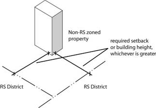
(i) Applicability
The Height limitations set out in this Section shall apply to any Building constructed in a non-RS Zoning District on a Parcel adjoining, or separated only by an Alley or a public Street from, a Parcel of land in any RS Zoning District, except that this limit shall not apply to any Building constructed in the CD Zoning District.
(ii) Height Limit Related to Setback
Any Building or Structure to which this Section is applicable shall be set back from the yard line adjoining the RS Zoning District by the minimum Setback established in Sec. 20-601 when the Building or Structure is the same or lesser Height than the Building or Structure on the adjoining RS Lot. When the Height of the Building or Structure exceeds the Height of the Building or Structure on the adjoining RS Lot, the minimum Setback for the non-RS zoned property shall be equal to the Building’s Height.
(3) Exceptions
(i) Except as specifically provided herein, the Height limits of this Development Code do not apply to any roof Structures for housing elevators, stairways, tanks, ventilating fans, solar energy Collectors, or similar equipment required in the operation or maintenance of a Building, provided that such Structures do not cover more than 33% of the roof area or extend over ten (10) feet in Height above the maximum Height allowed by the Base Districts.
(ii) Except as specifically provided herein, the Height limitations of this Development Code do not apply to radio Antennas, television Antennas, church spires, steeples, clock towers, water towers, flag poles, construction cranes, or similar attached and non-habitable Structures, which may be erected above the Height limit, nor to fire or parapet walls provided that such walls may not extend more than five (5) feet above the roof.
(iii) Telecommunication Towers may exceed the Zoning District Height limit if reviewed and approved as a Special Use in accordance with Sec. 20-1306.
20-901 General
The regulations of this Article are intended to ensure that the off-Street Parking, loading, and Access demands of various land uses will be met without adversely affecting surrounding areas. The regulations are also intended to help maintain a safe and efficient transportation system and advance other planning goals related to land use and the environment. In recognition of the fact that different approaches may be appropriate in different settings, the regulations allow flexibility in addressing vehicle Parking, loading, and Access demand.
(1)
The standards of this Section shall apply to all new development and
to existing development that is modified to the extent that it includes uses or
Buildings that were not specifically shown on
previously approved plans, except as provided in subsection (e) (f)
of this Section. All off-Street Parking Areas established by this Section shall be
continuously maintained according to the standards of this subsection.
(2) New Development
The Parking, loading and Access standards of this Section shall apply to any new Building constructed and any new use established in any Zoning District.
(3) Expansions, Modifications and Changes in Use to Existing Development
No Building or use already established on the Effective Date of this Development Code shall be expanded, modified or changed unless the following minimum Parking, loading and Access requirements for the expansion, modification or change in use have been satisfied.
(i) Expansions or Modifications
The Parking, loading and Access standards of this Section shall apply only in a proportionate amount to the extent of the change to the existing development that is created by expansion or modification of the Building according to the following table:
|
A Amount of Increase in Floor Area |
Applicability |
|
1% to 19% |
Parking, loading and Access standards apply to the expansion only. |
|
20% or greater |
Parking, loading and Access standards apply to the entire development. |
(ii) Change of Use
Additional off-Street Parking Spaces will be required to accommodate a change of use of a Structure of Parcel of land only when the new use requires 25% or more Parking Spaces than the previous use or 25 or more additional spaces, whichever is greater. In such cases, the new use shall provide at least 80% of the number of Parking Spaces required for the new use on the site.
Developments that provide parking in excess of the required standards must mitigate the impacts of the increased Impervious Surface through use of storm drainage Best Management Practices (BMPs) as provided in the City’s adopted BMP manual. [Mid-America Regional Council and American Public Works Association Manual for Best Management Practices for Stormwater Quality – Sept. 2003 and subsequent updates]. Single Family and duplex residential uses shall be exempt from this requirement.
The number of Parking and loading spaces existing on a site may not be reduced below the minimum requirements of this Section, except as provided in Sec. 20-213(e)(2).
No Building permits or certificates of occupancy shall be issued unless the minimum parking standards are being complied with, even though a site plan may have been approved previously that included fewer Parking Spaces, due to the unknown or changing status of occupancy.
Due to the unique characteristics of the Downtown Commercial District, allowed uses in the CD Zoning District are exempt from the requirement to provide off-Street Parking and off-Street loading spaces.
20-908 Location
Except as otherwise expressly provided in this section, required off-Street Parking and loading spaces shall be located on the same Lot as the Principal Use (See Sec. 20-905 for possible exceptions).
(b) Residential Districts
No part of a Parking Area, other than a Driveway, may be located within 25 feet of a Street right-of-way in any residential Zoning District.
(1) No more than 4 vehicles may be parked on Driveways or turnarounds within the required Front or Side Setback of any Lot in a residential Zoning District. Single or double Driveways and turnarounds may not be used to provide required off-Street Parking within the required Front or Exterior Side Setback with the exception of when they are serving a Duplex or Detached House.
(2) Driveway widths may not exceed 26 feet in residential Districts. All Driveway cuts into the Street require a permit and must be approved by the City Engineer in conformance with the standards outlined in Chapter 16, Article 3 of the City Code.
(3) In RS3 and RS5 Districts, residential driveways may be constructed a maximum of 12' wide to reduce pavement width and maintain the character of the neighborhood.
The location of off-Street Parking Areas in Commercial and Industrial Zoning Districts shall comply with the adopted city design standards and the following standards:
|
District |
Allowed Location |
Minimum Setbeck from Right-of-Way (feet) |
Minimum Setback from Residential Lot Lines (feet) |
|
CN1 |
Not allowed between the Facade of the Building with the main entrance and the Street. |
15
|
10
|
|
CO |
|||
|
CN2 |
|||
|
CD |
Prohibited between a Building and any Street |
||
|
CC |
No restriction except as specified in Article 5 |
||
|
CR |
|||
|
CS |
|||
|
IBP |
|||
|
IL |
|||
|
IG |
|||
|
H |
|||
|
GPI |
|||
|
OS |
20-1002 Street Trees
Street trees shall be provided at a rate of at least one Shade Tree per 40 feet
of public or private Street
Frontage, or
portion thereof. Required Street
trees shall be located within the required Street Setback, a minimum of 50’ behind the curb
line toward the interior of the Lot.
Street trees may
be clustered when circumstances prevent 40-foot spacing, such as Corner Lots where
trees would conflict with the sight triangle of motorists on the Streets, overhead
utility lines, utility Easements,
existing mature trees or topographic features. Street
Trees may also be clustered in groups of 3, 5 or 7 where such clustering is
combined with Berming,
trees and Shrubs in a planned manner and shown
on the approved site or development plan. If possible, it is encouraged
that street trees be planted between the back of curb and the sidewalk. In
cases where Street trees may be planted between the back of curb and sidewalk, the
planting strip shall be a minimum of 8 feet in width.
(a) In RS and RM12D Zoning Districts
(1) Street trees shall be located a maximum of 10’ from the boundary line of the right-of-way when no utility easement is present. If a utility easement is present, street trees shall be located a maximum of 18’ from the boundary line of the right-of-way.
(2) In the case of lots which are located on the radius of a cul-de-sac, street trees shall be located a maximum of 25’ from the boundary line of the right-of-way when no utility easement is present. If a utility easement is present, street trees shall be located a maximum of 33’ from the boundary line of the right-of-way.
(b) In Other Zoning Districts
Street trees shall be located a maximum of 30’ from back of curb, with the exception of lots on the radius of a cul-de-sac which shall be located no greater than 45’ from the back of curb.
20-1005 Bufferyards
The standards of this section are intended to mitigate the impacts associated with incompatible land uses on adjacent properties. The standards require landscape Bufferyards between such uses to minimize the harmful impacts of noise, dust/debris, glare and other objectionable activities.
The Bufferyard standards of this section apply to all development or redevelopment requiring site plan review.
(c) Table of Required Bufferyards
Bufferyards are required in accordance with the following table. To determine the type of Bufferyard required, first identify the zoning of the site that is being developed (the first column of the table) and each adjacent site (along the top of the table). Find where the zoning of the developing site and each adjacent site intersect on the table. If a Bufferyard is required, a numeral at the intersection will indicate the type of Bufferyard required. Width and landscape planting options for Bufferyards are explained in Sec. (d) through (f). Where the required Bufferyard is wider than the Side Setback required at that location, the Side Setback shall be expanded to accommodate the Bufferyard.
|
Developing Site’s Zoning |
Adjacent Site’s Zoning |
||||||
|
RS
|
RM
|
CN1, CO, CN2 |
CD |
CC, CR, CS |
IBP, IL, IG |
GPI, H |
|
|
RS Districts (Residential uses) |
– |
1 |
1 |
2 |
2 |
3 |
3 |
|
RS Districts (Nonresidential uses) |
1 |
1 |
1 |
1 |
2 |
3 |
2 |
|
RM Districts |
1 |
– |
1 |
– |
2 |
3 |
2 |
|
CN1, CO and CN2 Districts |
1 |
1 |
– |
– |
1 |
2 |
1 |
|
CD Districts |
2 |
– |
– |
– |
– |
– |
– |
|
CC, CR and CS Districts |
2 |
2 |
1 |
– |
– |
1 |
1 |
|
GPI and H Districts |
3 |
2 |
2 |
– |
– |
1 |
– |
|
IBP, IL and IG Districts |
3 |
3 |
2 |
– |
1 |
– |
1 |
20-1105 Sidewalks
Sidewalks shall be installed for any Significant Development Project, provided, that if sidewalks currently exist at the site, the Landowner will not be required to install new sidewalks at the site unless the existing sidewalk is recommended for condemnation by the Public Works Department pursuant to K.S.A. 12-1808. Financing of sidewalks shall be in accordance with the City’s adopted development policy.
(1) Sidewalks shall be installed according to specifications adopted by the City Commission.
(2) Minimum widths are as follows:
(i)
Arterial
Streets: 6 feet on each side of the Street;
(ii)
Collector and Local Streets: 5 feet on each side of the Street.
|
Street Type |
Minimum Sidewalk Width (in feet) |
|
Local |
5; Minimum width of 4 feet allowed in Original Townsite Area |
|
Collector |
5 |
|
Arterial |
6; A designated 10’ Bicycle/Recreation Path on one side of the Street and a 6’ sidewalk on the other side |
(3) The City Engineer is authorized to vary minimum sidewalk width and construction standards when the standards would be:
(i) impractical because of topography or site conditions;
(ii) inconsistent with the width of sidewalks on abutting sites; or
(iii) inconsistent with the pattern or material of sidewalks in older neighborhoods or historic districts.
Where compliance with design standards established in accordance with the Americans with Disabilities Act conflict with design standards set forth in this Article, the standards under the Americans with Disabilities Act will control. Where it is possible to comply with both the design standards under this Article and design standards established under the Americans with Disabilities Act by providing additional facilities or by otherwise modifying the design, then compliance with both sets of standards shall be required.
20-1301 General
The following table provides a summary of the procedures in this Article. In the event of conflict between this summary table and the detailed procedures in this Development Code, the detailed procedures govern.
|
Procedure |
Review and Decision-Making Bodies |
Notice |
|||
|
Staff |
PC |
BZA |
CC |
[2] |
|
|
Text Amendments (§20-1302) |
R |
<R> |
|
DM |
N |
|
Zoning Map Amendments (§20-1303) [3] |
R |
<R> |
|
DM |
N/P/M |
|
Planned Developments (§20-1304) |
|
|
|
|
|
|
Preliminary Development Plan |
R |
<R> |
|
DM |
N/P/M |
|
Final Development Plan |
DM |
|
|
<A> |
M |
|
Site Plan Review (§20-1305) |
DM |
|
|
<A> [4] |
P/M |
|
Special Uses (§20-1306) |
R |
<R> |
|
DM |
N/P/M |
|
Zoning Variances (§20-1307) |
R |
|
<DM> |
|
N/M |
|
Written Interpretations (§20-1310) |
DM |
|
<A> [5] |
|
|
|
Appeals of Administrative Decisions (§20-1311) |
|
|
<DM> |
|
N/M |
PC = Planning Commission • BZA = Board of Zoning Appeals • CC = City Commission
<>= Public Hearing Required
[1] R = Review Body (Responsible for Review and Recommendation); DM = Decision-Making Body (Responsible for Final Decision to Approve or Deny); A = Authority to hear and decide appeals of Decision-Making Body’s action.
[2] Notices: N = Newspaper (published); P = Posted (signs); M = Mailed (See sub-section (q) of this section)
[3] See Sec. (d) for special procedures applicable to UC, Urban Conservation District zoning map amendments.
[4] City Commission is authorized to hear and decide appeals of Planning Director’s decision on Site Plans.
[5] Appeals processed as “Appeals of Administrative Decisions.”
Unless otherwise expressly stated, applications for review and approval under this Article may be initiated by (1) all the Owner of the property that is the subject of the application; (2) the Landowners’ authorized Agent; or (3) any review or decision-making body.
Applications required under this Development Code shall be submitted in a form and in such numbers as required by the official responsible for accepting the application. Officials responsible for accepting applications shall develop checklists of submittal requirements and make those checklists available to the public. Application forms and checklists of required submittal information are available in the office of the Planning Director.
(1) All applicants for matters that require a public hearing are required to attend a pre-application meeting with staff. Pre-application meetings are also required whenever the provisions of this Article expressly state that they are required. Pre-application meetings shall be scheduled by the applicant to allow adequate time to review and respond to issues raised at the pre-application meeting. The meeting shall occur at least 7 Working Days before submitting an application.
(2) All other applicants are encouraged to arrange a pre-application meeting with City staff. The Planning Director will provide assistance to applicants and ensure that appropriate City staff members are involved in pre-application meetings.
The Planning Director may, after consulting with review and decision-making bodies, promulgate processing cycles for applications. Processing cycles may establish:
(1) deadlines for receipt of complete applications;
(2) dates of regular meetings;
(3) the scheduling of staff reviews and staff reports on complete applications; and
(4) any required time-frames for action by review and decision-making bodies.
Applications shall be accompanied by the fee amount that has been established by the City Commission. Fees are not required with applications initiated by review or decision-making bodies. Application fees are nonrefundable.
(1) An application will be considered complete and ready for processing only if it is submitted in the required number and form, includes all required information and is accompanied by the required filing fee.
(2) Within 5 Working Days of application filing, the Planning Director shall determine whether the application includes all information required for processing (See Sec. 20-1301(c)) If an application does not include all of the required information it will be deemed incomplete. If an application includes all of the required information it will be deemed complete. If the application is deemed incomplete, written notice shall be provided to the applicant and the applicant’s Agent. The notice shall include an explanation of the application’s deficiencies.
(3) No further processing of incomplete applications will occur and incomplete applications will be pulled from the processing cycle. When the deficiencies are corrected, the application will be placed in the next processing cycle. If the deficiencies are not corrected by the applicant within 60 days, the application will be considered withdrawn. If an application is deemed withdrawn because of failure to correct application deficiencies, notice shall be sent to the applicant and the applicant’s Agent.
(4) Applications deemed complete will be considered to be in the processing cycle and will be reviewed by staff and other review and decision-making bodies in accordance with the procedures of this Article and the processing cycles established under Sec. 20-1301(e).
(5) The Planning Director may require that applications or plans be revised before being placed on the agenda of the Planning Commission or City Commission if the Planning Director determines that:
(i) the application or plan contains one or more significant inaccuracies or omissions that hinder timely or competent evaluation of the plan’s/application’s compliance with Development Code standards;
(ii) the application contains multiple minor inaccuracies or omissions that hinder timely or competent evaluation of the plan’s/application’s compliance with Development Code standards;
(iii) the application or plan cannot be approved without a variance or some other change or modification that the decision-making body for that application or plan does not have the authority to make.
(6) Applications that contain the aforementioned types of inaccuracies or that substantially fail to comply with Development Code standards shall be revised before they will be placed on agenda of the Planning Commission or City Commission.
(7) Action or inaction by the Planning Director under this section may be appealed to the Board of Zoning Appeals.
(1) A public hearing for which proper notice was given may be continued by the Board of Zoning Appeals or Planning Commission to a later date without providing additional notice as long as the continuance is set for specified date and time and that date and time is announced at the time of the continuance.
(2) If a public hearing is tabled or deferred by the Board of Zoning Appeals or Planning Commission for an indefinite period of time or postponed more than three (3) months from the date of the originally scheduled public hearing, new public notice shall be given, in accordance with the notice requirements of the respective procedure, before the rescheduled public hearing.
(3) The applicant or Landowner who requests the postponement is responsible for paying the cost of re-notification per the adopted schedule of fees for publication, and payment of re-notification costs shall be made before the item is placed on the agenda.
(1) Review bodies may take any action that is consistent with:
(i) the regulations of this Article;
(ii) the City’s adopted Development Policy;
(iii) any by-laws that may apply to the review body; and
(iv) the notice that was given.
(2) The review body’s action may include recommending approval of the application, recommending approval with modifications or conditions, or recommending disapproval of the application.
(3) The review body may recommend conditions, modifications or amendments if the effect of the condition, modification or amendment is to allow a less intensive use or Zoning District than indicated in the application, reduce the impact of the development, or reduce the amount of land area included in the application.
(4) The review body may recommend that the application be approved conditionally upon the execution of a development agreement acceptable to the Director of Legal Services and/or compliance with the Access Management Standards and Commercial Design Policies and Standards adopted by the City Commission from time to time.
(5) Review bodies may not recommend a greater Density of development; a more intensive use or a more intensive Zoning District than was indicated in the public notice.
(6) Review bodies are not required to recommend approval of the maximum Density or intensity of use allowed.
(1) Decision-making bodies may take any action that is consistent with:
(i) the regulations of this Article;
(ii) the City’s adopted development policy;
(iii) any by-laws that may apply to the decision-making body; and
(iv) the notice that was given.
(2) The decision-making body’s action may include approving the application, approving the application with modifications or conditions, or denying the application. A denial of application may be accompanied with a remand to the review body, if any, for further consideration.
(3) The decision-making body may impose conditions on the application or allow modifications or amendments if the effect of the condition, modification or amendment is to allow a less intensive use or Zoning District than indicated in the application or to reduce the impact of the development or to reduce the amount of land area included in the application.
(4) The decision-making body may approve the application upon the condition that the applicant execute a development agreement acceptable to the Director of Legal Services and/or compliance with the Access Management Standards and Commercial Design Policies and Standards adopted by the City Commission from time to time.
(5) Decision-making bodies may not approve a greater Density of development; a more intensive use or a more intensive Zoning District than was specified in the public notice.
(6) Decision-making bodies are not required to approve the maximum Density or intensity of use allowed.
Pursuant to K.S.A. 12-757, the Planning Commission may adopt a “Lesser Change Table.” The Lesser Change Table is for the use of the Planning Commission in determining the hierarchy of Zoning Districts and for determining when public notification or re-notification is required. Such a table lists zoning classifications, by category, in ascending order from the least intense to the most intense. The Planning Commission’s Lesser Change Table shall identify only the hierarchy of Zoning Districts within each of the three categories of Base Districts—Residential, Commercial and Industrial. It is not intended to identify hierarchical arrangements among Districts in different categories. For example, the Lesser Change Table may classify the RS40 District as less intense than the RS20 District, but it may not classify (R) Residential Districts as less intense than (C) Commercial Districts, or vice-versa. The Lesser Change Table shall be filed with the Planning Director.
In all cases, the burden is on the applicant to show that an application complies with applicable review or approval criteria.
When the procedures of this Article allow review bodies to recommend or decision-making bodies to approve applications with conditions, the conditions shall relate to a situation created or aggravated by the proposed use or development. When conditions are imposed, an application will not be deemed approved until the applicant has complied with all of the conditions.
Once on a published and distributed agenda, Planning Commission action is required to defer an item. If an application is requested for deferral from the next Planning Commission agenda prior to publication of the agenda, the applicant may defer an item by submitting a written request to the Planning Director. For Deferred Items, the Landowner or applicant shall provide an updated property Ownership list from the County Clerk’s office for items that have been deferred from an agenda for 3 or more months. If deferred at the applicant or Landowner’s request, the cost of republication of legal notice in the newspaper shall be paid by the applicant or Landowner. If an item is deferred by the Planning Commission, no republication fee will be charged.
For Inactive Files, the Planning Director may notify the applicant and applicant’s Agent in writing that a file has been closed when the file has been inactive for a period of time equal to or exceeding 12 months. Requests for action after a file has been declared inactive and the applicant has been notified require resubmittal as a new application. Review fees and cost of publication are required to be paid as part of the resubmittal.
(1) When a review or decision-making body fails to take action on an application within any time limit that is specified in or under this Article (as with an application processing cycle), that inaction will be interpreted as a recommendation of approval or a decision to approve, respectively. The Effective Date of such a “non-action” approval or recommendation of approval will be the date that action was required to have occurred under the required time limit.
(2) Time limits for action may be extended if the applicant gives written consent to the extension or the applicant submits a written request for a deferral and agrees in writing to an extension of the time for action.
(3) When a review body fails to take action on an application within any time limit that is specified in this Article, the decision-making body is free to proceed with its own action on the matter without awaiting a recommendation.
The notice provisions of this section apply except as otherwise expressly stated.
(1) Content
All notices required under this
Development Code shall: (1) indicate the date, time and place of the public
hearing or date of action that is the subject of the notice; (2) describe the
property involved in the application by Street address or by general description; (3)
describe the nature, scope and purpose of the application or proposal; and (4)
indicate where additional information on the matter can be obtained.
(i) Newspaper and Mailed Notice
All Newspaper and Mailed Notices shall:
(1) indicate the date, time and place of the public hearing or date of action that is the subject of the notice;
(2) describe the property involved in the application by Street address or by general description;
(3) describe the nature, scope and purpose of the application or proposal; and
(4) indicate where additional information on the matter can be obtained.
(ii) Posted Notice
All Posted Notices shall:
(1) indicate the date, time and place of the public hearing or date of action that is the subject of the notice;
(2) state the language “Development Activity Proposed”, and
(3) indicate where additional information on the matter can be obtained.
(2) Newspaper Notice
When the provisions of this Development Code require that “Newspaper Notice” be provided, the City is responsible for ensuring that notice is published in the official newspaper of the City of Lawrence. The notice shall appear in the newspaper at least 20 days before the date of the public hearing.
When the provisions of this Development Code require that “Mailed Notice” be provided:
(i) Owner Notice; Radius
The official responsible for accepting the application shall mail notice to the record Owner of the subject property and all Owners of property located within 200 feet of the subject property. If the subject property abuts the City limits, the area of notification shall be extended to at least 1,000 feet into the unincorporated area.
(ii) Notice to Registered Neighborhood Associations
The official responsible for accepting the application shall mail notice to any Registered Neighborhood Associations whose boundaries include or are contiguous to the subject property.
(iii) Ownership Information
The applicant is responsible for providing certified Ownership
ownership information. Current ownership information shall be
obtained from the Douglas County Clerk. ownership Ownership information
will be considered current if, at the time of submission, it is no more than 10
30 days old.
(iv) Timing of Notice
Required notices shall be deposited in the U.S. mail at least 20 days before the public hearing, meeting, or date of action that is the subject of the notice. When required notices have been properly addressed and deposited in the mail, failure of a party to receive such notice will not be grounds to invalidate any action taken.
(i) When the provisions of this Development Code require that “Posted Notice” be provided, the applicant shall ensure that notice is posted on the subject property.
(ii) Posted notice shall be in the form of official signs provided by the City.
(iii) Posted notice shall be clearly visible to neighboring residents and passers-by from each public Street bordering the subject property. At least one sign shall be posted on each Street Frontage. The Planning Director is authorized to require the posting of additional signs when deemed necessary for effective public notice, but not more than one sign per 300 feet of Street Frontage may be required.
(iv) Posted notice shall remain in place for at least 20 days before the public hearing, meeting, or date of action that is the subject of the notice.
(v) During the required notice period, the applicant shall periodically check the condition of the sign and shall replace it if it is no longer legible for any reason, whether through Act of God, vandalism, defect in installation or vegetative growth.
(vi)
For any application requiring posted notice, the applicant
shall supplement the application with an affidavit of posting and notice at
least seven but no more than ten days before the scheduled hearing no
sooner than the date the sign is posted but no later than seven (7) days prior
to the scheduled public hearing, meeting, or date of action that is the subject
of the notice. Failure to make timely delivery of such affidavit to
the Planning Director
shall render the application incomplete and subject it to removal from the
agenda on the hearing date, at the discretion of the Planning Commission.
(vii) The applicant shall remove notice signs required by this section within 10 days of the date that the decision-making body takes action or the date that the application is withdrawn. Failure to properly post or maintain such signs is grounds for deferral or denial of the application.
(viii) For applications that do not abut public Streets, the Planning Director is authorized to approve an alternative form of posted notice that will be visible to passers-by.
(ix) The public may submit written statements regarding a specific development proposal that, when the written statement is submitted by the published deadline for receiving public comment, will become a part of the official record in the planning department.
(x) Parties affected by the actions of a decision making body have the right to appeal the action taken in accordance with the procedures set out in Article 13 of this Chapter.
Unless otherwise specifically provided in this ordinance, written findings are not required for a final decision on any application. Provided, however, that any decision may be expressly made subject to the subsequent adoption of written findings and, in such cases, the decision shall not be considered final until such findings are adopted. Provided further, that where an appeal of any quasi-judicial decision has been filed in the District Court of Douglas County pursuant to K.S.A. 12-760 or K.S.A. 60-2101(d) in cases where written findings have not been adopted, written findings shall be adopted by the approving authority within 45 days of service of the appeal on the City and thereafter shall be certified to the District Court as part of the administrative record. The 45-day time period for adoption and certification of findings may be extended with the permission of the District Court.
Adoption of an ordinance is required in the case of a zoning text amendment, rezoning and special use permit. In such instances, the decision approving the application shall not be deemed to be final until the ordinance has been published in an official City newspaper.
20-1304 Planned Developments
PD, Planned Development Overlay Districts are established through the approval of zoning map amendments, in accordance with the hearing and notice requirements of Sec. 20-1303. PD zoning map amendments shall only be processed concurrently with a Preliminary Development Plan application. Final Development Plan approval is required after approval of the zoning map amendment and Preliminary Development Plan. This section sets forth the required review and approval procedures for PD Preliminary and Final Development Plans.
Concurrent submission and processing of Preliminary and Final Development Plans is allowed for a single-use Structure as long as individual plans are submitted that meet the Preliminary and Final Development Plan standards and criteria. All other developments (those that involve multiple Structures or multiple uses) require review and approval of a Preliminary Development Plan before submittal of a Final Development Plan.
(c) Prerequisite to Building Permit
Approval of PD Preliminary and Final Development Plans, and recording with the Register of Deeds, shall occur before any Building Permit is issued and before any Development Activity takes place in a PD District.
(1) Application Filing
Preliminary Development Plan applications shall be filed with the Planning Director at the same time as a PD zoning map amendment application. The application shall be accompanied by required fees.
(2) Neighborhood Input
(i) During the design process for the Preliminary Development Plan, the applicant shall make a reasonable effort to meet with individuals, required to be mailed notice under Sec. (q)(3), to present their project in conceptual fashion and to solicit input on the proposed design.
(ii) A statement describing the reasonable effort(s) made to meet with and receive input from individuals required to receive notice shall be submitted with the Preliminary Development Plan application when it is filed for review at the Planning Department.
(3) Application Contents
(i) The application shall include a General Location Map, which shall show the location of the property in relation to at least one intersection of two Streets shown as Collector or Arterial Streets on the City’s Major Thoroughfares Map of the Comprehensive Plan.
(ii) The application shall include a statement by the Landowner setting forth the reasons why, in his or her opinion, a Planned Development would be in the public interest and would be consistent with the Developer’s Statement of Intent for Planned Development
(iii) The Preliminary Development Plan submitted by the Landowner as part of his or her application for tentative approval shall be prepared at a scale no smaller than one inch to 50 feet and shall include all of the area proposed to comprise the Planned Development. The plan and supporting documents shall include the following information:
a. A legal description of the site;
b. The dimensions of all property boundaries;
c. The Owner of record and any other parties having an interest in the proposed development;
d. A topographical survey of the site at an interval of not more than two feet or a more detailed plan if requested by the Public Works Department;
e. The location of all existing Structures, Easements, utilities, proposed utilities, and public dedication either through, adjacent to or on the site;
f. The existing public and private Street system, platted or unplatted ownership, type and location of Structures, curb cuts on adjacent properties and along the opposite side of the Street and topography extending 100 feet beyond the outside boundaries of the proposed development;
g. The width, Grade, location and ownership of all proposed public and private Streets and sidewalks in the area to be developed;
h. The use, Height, Floor Area, and approximate location of all proposed Buildings and other Structures;
i. The number ofDwelling Units to be contained in each Building proposed for residential use;
j. The location, dimension and capacity of all proposed off-Street Parking Areas in the area to be developed;
k. The location, dimension, acreage, and Ownership of all proposed public and private recreation areas, Open Space and Non-encroachable Areas;
l. Dimensions and notes as deemed necessary to show compliance with the development standards of this Article;
m. A schedule showing the proposed time and sequence within which the applications for final approval of all portions of the Planned Development are intended to be filed. The Planning Commission may either approve or modify the submitted development time schedule. The development phases as shown on the time schedule shall also be indicated on the plan.
n. As part of the development time schedule each phase shall have a summary of the number of units of each type of use, the number ofDwelling Units, the acreage devoted to residential, non-residential, commercial, recreation, Open Space, Non-encroachable Area, Streets (both public and private), off-Street Parking, and other major land uses, Density, public lands (existing and proposed), and the total number of acres contained in each development phase;
o. A summary of the total number of units of each type of use, number ofDwelling Units, the acreage devoted to all major land uses, the acreage of public lands and areas proposed for public Ownership, the acreage of the total area proposed to be developed, and the overall Net Density of the development;
p. A statement as to the feasibility of proposals for the disposition of sanitary waste and storm water, and how all utilities are to be provided including sewerage, water, storm drainage, gas and electricity, and how completion of all improvements is to be guaranteed;
q. A statement as to the form of Ownership proposed to own and maintain the Common Open Space, recreation facilities, Non-encroachable Area and any other area within the area proposed to be developed that is to be retained primarily for the exclusive use and benefit of the residents, lessee and Owner of the Planned Development;
r. A statement as to the substance of the covenants, grants of Easements or other restrictions to be imposed upon the use of the land; Buildings and Structures, including proposed Easements or grants for public utilities;
s. The Landowner shall also submit a tentative dedication clause including dedication of public utility and drainage Easements, Street rights-of-way and the following statement: "We hereby dedicate to the City of Lawrence the right to regulate any construction over the area designated as Common Open Space, open air recreation area, and Non-encroachable Area and to prohibit any construction within said areas and spaces inconsistent with the approved use or enjoyment of residents, lessees and Owner of the Planned Development;"
t. A statement specifying those variances, modifications, reductions and waivers being requested as part of the plan approval and setting forth reasons why, in the opinion of the Landowner, such should be allowed;
u. At least one north-south and one east-west elevation across the site to show typical site layout, Grade, etc.; and
v. Submission of a landscape plan in conformance with Sec. 20-1001(d).
(iv) The plan shall be submitted so as to conform with the requirements for the submission of a Preliminary Plat in the Subdivision Regulations, except where such requirements conflict with the requirements of this Article.
(v) Approval of the Preliminary Development Plan shall constitute approval of a Preliminary Plat. A preliminary plat review fee shall not be required.
(vi) Provide the supplemental stormwater information required by City Regulations, and provide on the development plan a site summary table which indicates: the area (in sq. ft.) and percentage of the site proposed for development as a Building(s); development as a paved surface; undeveloped and planted with grass, Ground Cover, or similar vegetative surface. When a development is proposed to be phased, the entire detention basin shall be provided during phase one of the project unless otherwise approved.
(4) Phased Development Schedule
If the applicant proposes to develop a PD in phases, the application shall contain a proposed phasing schedule. In a phased development, Open Space and site amenities shall be apportioned among the phases in proportion to the amount of development occurring in each phase, so that, for example, when the development is 40% complete, 40% of the Open Space and amenities will be complete, transferred to the association or other permanent Owner, and properly restricted as required by this Code.
(5) Public Hearing Notice
Newspaper, posted and mailed notice of the Planning Commission’s public hearing shall be provided in accordance with Sec. (q).
(6) Staff Review/Report
The Planning Director shall review each proposed PD zoning map amendment and Preliminary Development Plan in accordance with the review and decision-making criteria of Sec. (9) and distribute the proposed plan to other agencies and reviewers. Based on the results of those reviews, the Planning Director will provide a report on the proposed amendment/plan to the Planning Commission and City Commission.
(7) Planning Commission’s Review/Recommendation
(i) The Planning Commission shall hold a public hearing on the proposed amendment/plan, review the proposed amendment/plan in accordance with the review and decision-making criteria of Sec. (9) and recommend that the City Commission approve, approve with conditions or deny the proposed amendment/plan. The Planning Commission is also authorized to forward the proposed amendment/plan to the City Commission with no recommendation.
(ii) The recommendation on the Preliminary Development Plan shall include findings of fact and set forth reasons for the recommendation, including but not limited to findings of fact on the review and approval criteria of Sec. (9).
(iii) The Planning Director shall give written notice of the Planning Commission’s recommendation to the applicant and the applicant’s Agent.
(8) City Commission Decision
After receiving the Planning Commission’s recommendation, the City Commission shall take one of the following actions on the proposed amendment/plan:
(i) approve, approve with conditions or modifications, or deny; or
(ii) return the application to the Planning Commission for further consideration, together with a written explanation of the reasons for the City Commission’s failure to approve or disapprove.
a. The Planning Commission, after considering the explanation of the City Commission, may resubmit its original recommendations with its reasons for doing so or submit a new and amended recommendation.
b. Upon the receipt of such recommendation, the City Commission may, by a simple majority vote, approve the proposed amendment/plan, approve it with conditions or modifications, or deny it.
c. If the Planning Commission fails to deliver its recommendations to the City Commission following the Planning Commission's next regular meeting after receipt of the City Commission’s report, the City Commission will consider such course of inaction on the part of the Planning Commission as a resubmission of the original recommendations and proceed accordingly.
(iii) The City Commission may act by a simple majority vote, except for the following cases:
a. action that is contrary to the Planning Commission's recommendations, in which case the decision shall be by a 2/3 majority vote of the full membership of the City Commission; or
b. approval, or approval with conditions or modifications, when a valid protest petition has been submitted in accordance with Sec. 20-1306(g) in which case the decision shall be by a 3/4 majority vote of the full membership of the City Commission.
(iv) The City Commission shall:
a. State the reasons for its decision in writing; and
b. notify the applicant, and all other parties who have made a written request for notification, in writing of its decision and the reasons for its decision.
(9) Review and Decision-Making Criteria
In reviewing and making decisions on proposed Preliminary Development Plans, review and decision-making bodies shall consider at least the following factors:
(i) the Preliminary Development Plan’s consistency with the Comprehensive Plan;
(ii) the Preliminary Development Plan’s consistency with the PD standards of Sec. 20-701 including the statement of purpose;
(iii) the nature and extent of Common Open Space in the PD;
(iv) the reliability of the proposals for maintenance and conservation of Common Open Space;
(v) the adequacy or inadequacy of the amount and function of Common Open Space in terms of the densities and Dwelling types proposed in the plan;
(vi) whether the Preliminary Development Plan makes adequate provisions for public services, provides adequate control over vehicular traffic, and furthers the amenities of light and air, recreation and visual enjoyment;
(vii) whether the Preliminary Development Plan will measurably and adversely impact development or conservation of the neighborhood area by:
a. doubling or more the traffic generated by the neighborhood;
b. proposing housing types, Building Heights or Building massing(s) that are incompatible with the established neighborhood pattern; or
c. increasing the residential Density 34% or more above the Density of adjacent residential properties.
(viii) whether potential adverse impacts have been mitigated to the maximum practical extent; and,
(ix) the sufficiency of the terms and conditions proposed to protect the interest of the public and the residents of the PD in the case of a plan that proposes development over a period of years.
(10) Effect of Preliminary Development Plan Approval
Approval of the Preliminary Development Plan constitutes approval of a preliminary plat. A preliminary plat review fee is not required.
(11) Status of Preliminary Development Plan after Approval
(i) The applicant and the applicant’s Agent shall be given written notice of the action of the City Commission.
(ii) Approval of a Preliminary Development Plan does not qualify as a plat of the Planned Development for Building and permitting purposes.
(iii) An unexpired approved Preliminary Development Plan, including one that has been approved subject to conditions provided that the Landowner has not defaulted on or violated any of the conditions, may not be modified or revoked by the City without the consent of the Landowner.
(iv) If a Landowner chooses to abandon a plan that has been given preliminary approval, he or she may do so prior to Final Development Plan approval, provided that he or she notifies the Planning Commission in writing.
(v)
Major Changes in the Planned Development (Sec 20-1304(C)(2)(iv))
(Sec 20-1304(e)(iv)) may be made only after rehearing and
reapproval of the entire Preliminary Development Plan under the terms and
procedures specified in this section. All Landowners
within the entire Preliminary Development Plan boundary shall be notified in
writing of any proposed Major Change at the time of submittal of the revised
Preliminary Development Plan to the Planning Director.
(vi) An approved Preliminary Development Plan with multiple Parcel and multiple Landowners may only be altered or modified if all Landowners of Parcel within the Preliminary Development Plan consent to the proposed alterations or modifications.
(vii) A Preliminary Development Plan may be explicitly conditioned with a provision on the face of the Preliminary Development Plan that all Landowners of all properties waive their right to approve or disapprove any alterations or modifications to the Preliminary Development Plan.
(viii) In the absence of the explicit condition contained in subsection (9), the provision of subsection (v) will govern Preliminary Development Plan alterations or modifications.
(12) Expiration of Approval
In the event the Landowner fails to file an application for Final Development Plan approval within 18 months after final approval of the Preliminary Development Plan has been granted or within 6 months after the date shown on an approved development schedule, in accordance with Sec. 20-1304(d)(4) then such approval shall expire in accordance with the following provisions:
(i) For good cause shown, the expiration date may be extended by the City Commission for a period not to exceed 6 months, or the proposed phasing schedule may be modified to extend all dates by a period not to exceed one-half the original period allowed for development of that phase. The application for extension or modification may be made by letter to the Planning Director and will be considered only if received before the expiration date of the approval. The Planning Director shall forward such request, with any recommendation of the Planning Director, to the City Clerk for scheduling on the agenda of the City Commission. The Planning Director shall notify the applicant by first class mail of the date of the proposed consideration by the City Commission. On that date, the City Commission shall hear from the applicant and the Planning Director and may hear from other interested parties. Only one such extension may be granted.
(ii) If the approval of the Preliminary Development Plan for a phased development expires after the completion of one or more phases, the Preliminary Development Plan will remain in full effect as to those portions of the development that are subject to Final Development Plans in which the developer has acquired vested rights, in accordance with Sec. 20-1304(e)(2)(vii) but the remaining portions of the Preliminary Development Plan shall expire.
(iii) No action by the City shall be necessary to cause the approval to expire. Its expiration shall be considered a condition of the original approval. After the expiration date, or extended expiration date, any further application for Final Development Plan or for other Development Activity on the site shall be considered as though the Preliminary Development Plan had not been granted.
(iv) After expiration of a Preliminary Development Plan, or any portion thereof, the PD Overlay zoning shall remain in effect for the affected property, but further development on the property shall require the approval of a new Preliminary Development Plan, in accordance with the procedures and standards in effect at the time of the new application. If a Preliminary Development Plan has expired for any part of a phased development, consistency with the developed parts of the Preliminary Development Plan shall be an additional criterion for consideration of a new proposed Preliminary Development Plan.
(v) Approval of a Preliminary Development Plan does not, in itself, vest any rights under K.S.A. Sect. 12-764.
(1) Application Filing
Final Development Plan applications shall be filed with the Planning Director after approval of and before the expiration of a Preliminary Development Plan. A Final Development Plan may be submitted for a portion of the area in the approved Preliminary Development Plan.
(2) Application Contents
(i) Final Development Plan, in its entirety or in phases, drawn at a scale of one inch to 40 feet and supportive documents shall show or contain at least the following:
a. all information required of the Preliminary Development Plan;
b. the placement of all principal and Accessory Structures;
c. the entrances to all Structures;
d. the location and dimensions of all existing and proposed curb cuts, Driveways and aisles, public and private Streets, off-Street Parking and loading space areas, sidewalks and pedestrianways, sanitary sewers, storm sewers and drainageways, power lines, gas lines, and fire hydrants;
e. the location, Height and material of Screening walls and fences;
f. the type of surfacing and base course proposed for all private Streets, Driveways, off-Street Parking and loading space areas, and sidewalks and pedestrianways;
g. the location of all utilities in and adjacent to the property. (No overhead lines, with the exception of high voltage power lines, shall be permitted in Planned Developments);
h. a location map of one inch equals 200 feet or less showing the site of the proposed development in relationship with major Thoroughfares in the city;
i. a landscape plan in accordance with Sec. 20-1001(d);
j. the proposed topography or grading of the area at a contour interval of not more than two feet;
k. the location of each outdoor trash storage facility;
l. proof of the establishment of an agency or entity to own, manage and maintain the Common Open Space, open air recreation areas, recreation facilities, Non-encroachable Areas, private Streets and any other area within the development that is to be retained for the exclusive use and benefit of the residents, lessees and Owner;
m. copies of all restrictions or covenants that are to be applied to the development area;
n. proof that no Lot, Parcel, Tract or other portion of the development area has been conveyed or leased prior to the recording of any restrictive covenants, Final Development Plan, or final plat; and
o. such other drawings, specifications, covenants, Easements, conditions, and performance bonds as set forth in the granting of preliminary approval.
(ii) A plan submitted for final approval shall be in substantial compliance with the plan previously given preliminary approval. Modification by the Landowner of the plan as preliminarily approved may not:
a. Increase the proposed gross residential Density or intensity of use by more than five percent (5%) or involve a reduction in the area set aside for Common Open Space, open air recreation area or Non-encroachable Area, nor the substantial relocation of such areas; nor,
b. Increase by more than 10 percent (10%) the total Floor Area proposed for non-residential or commercial uses; nor,
c. Increase by more than 5 percent (5%) the total ground area covered by Buildings nor involve a substantial change in the Height of Buildings.
(iii) Consistency with Preliminary Development Plan; Major Changes
A Final Development Plan will not be considered complete and ready for processing if all approved conditions have not been met or if the Final Development Plan constitutes a Major Change from the approved Preliminary Development Plan. Major Changes may be made only after rehearing and reapproval of the Preliminary Development Plan, and the Planning Director shall notify the applicant of the provisions of this section.
(iv) Major Changes
A Major Change is one that:
a. increases the proposed gross residential Density or intensity of use by more than five percent (5%)
b. involves a reduction in the area set aside for Common Open Space in general, or Recreational Open Space or Natural Open Space in particular, or the substantial relocation of such areas;
c. increases by more than 10 percent (10%) the total Floor Area proposed for nonresidential uses;
d. increases by more than 5 percent (5%) the total ground area covered by Buildings;
e. changes a residential use or Building type;
f. increases the Height of Buildings by more than 5 feet; or
g. represents a new change to the Preliminary Development Plan that creates a substantial adverse impact on surrounding Landowners.
h. changes a residential Building type or a non-residential structure by more than 10% in size.
(v) Review and Action by Planning Director; Appeals
a. Within 45 days of the filing of a complete Final Development Plan application, the Planning Director shall review and take action on the Final Development Plan. The Planning Director shall approve the Final Development Plan if it complies with the approved Preliminary Development Plan, all conditions of Preliminary Development Plan approval and all applicable standards of this Development Code. If the submitted Final Development Plan does not so comply, the Planning Director shall disapprove the Final Development Plan and advise the Landowner in writing of the specific reasons for disapproval
b. In the event that the Planning Director does not approve the Final Development Plan, the Landowner may either: (1) resubmit the Final Development Plan to correct the plan’s inconsistencies and deficiencies, or (2) within 45 days of the date of notice of refusal, appeal the decision of the Planning Director to the City Commission. In the event such an appeal is filed, a public hearing before the City Commission shall be scheduled with such notice as is required for the Preliminary Development Plan/Zoning Map Amendment.
c. Notice shall be given of the Planning Directors’ action to adjacent property Owner or Neighborhood Associations if such request for notice has been made in writing from the adjacent property Owner or Neighborhood Associations.
(vi) Effect of Approval
a. A Final Development Plan or any part thereof that has received final approval shall be so certified by the Planning Director, and shall be filed by the Planning Director with the Register of Deeds immediately upon compliance with all conditions of approval. If the Landowner chooses to abandon a Final Development Plan or portion thereof after it has been given final approval, he or she shall notify the Planning Director in writing.
b. The filing of a Final Development Plan for a Planned Development with the Register of Deeds does not constitute the effective dedication of Easements, rights-of-way or Access control, nor will the filed plan be the equivalent of, nor an acceptable alternative for, the final platting of land prior to the issuance of Building Permits in the Planned Development.
c. The Planning Director shall file the final plats and all supportive documents concerning the Planned Development with the Register of Deeds. The Landowner is responsible for all costs incurred in filing such documents and the Final Development Plan.
(vii) Expiration of Approval
In the event the Landowner fails to submit a final subdivision plat or begin actual development shown on the Final Development Plan within 12 months after final approval of the Final Development Plan has been granted, the approval shall expire in accordance with the following provisions:
a. For good cause shown, the expiration date may be extended by the City Commission for a period not to exceed 6 months. The application for extension may be made by letter to the Planning Director and will be considered only if received before the expiration date of the approval. The Planning Director shall forward such request, with any recommendation of the Planning Director, to the City Clerk for scheduling on the agenda of the City Commission. The Planning Director shall notify the applicant by first class mail of the date of the proposed consideration by the City Commission. On that date, the City Commission shall hear from the applicant and the Planning Director and may hear from other interested parties. Only one such extension may be granted.
b. No action by the City shall be necessary to cause the approval to expire. Its expiration shall be considered a condition of the original approval. After the expiration date, or extended expiration date, any further application for subdivision review, for a Building Permit or for other Development Activity on the site shall be considered as though the Final Development Plan had not been granted.
c. After expiration of a Final Development Plan and related portions of the Preliminary Development Plan, the PD Overlay zoning shall remain in effect, but further development on the property shall require the approval of a new Preliminary Development Plan and Final Development Plan, in accordance with the procedures and standards in effect at the time of the new application.
d. Rights to the development pattern shown in a Final Development Plan shall vest in accordance with K.S.A. Sect. 12-764 upon approval of a final subdivision plat. If such subdivision plat expires in accordance with K.S.A. Sect. 12-764(a), then the related portions of the Final Development Plan shall also expire at the same time.
(1) Enforcement by the City
The provisions of a Final Development Plan relating to: (1) the use of land and the use, bulk and location of Buildings and Structures; (2) the quality and location of Common Open Space; and, (3) the intensity of use or the Density of residential units, run in favor of the municipality and are enforceable in law or in equity by the City, without limitation on any powers or regulations otherwise granted the City by law.
(2) Enforcement by Residents and Landowners
All provisions of the Final Development Plan run in favor of the residents and Landowners of the Planned Development, but only to the extent expressly provided in, and in accordance with, the Final Development Plan. To that extent, the Final Development Plan provisions, whether recorded by plat, covenant, Easement or otherwise, may be enforced at law or equity by said residents and Landowners, acting individually, jointly, or through an organization designated in the Final Development Plan to act on their behalf. No provisions of the Final Development Plan will be implied to exist in favor of residents and Landowners of the Planned Development except those portions of the Final Development Plan that have been finally approved and have been recorded.
(3) Modifications of the Final Development Plan by the City
All those provisions of the Final Development Plan authorized to be enforced by the City may be modified, removed or released by the City (except grants or Easements relating to the service or equipment of a public utility unless expressly consented to by the public utility), subject to the following conditions:
(i) no such modification, removal or release of the provisions of the Final Development Plan by the City may affect the rights of the residents and Landowners of the Planned Development to maintain and enforce provisions, at law or equity; and
(ii) no modification, removal or release of the provisions of the Final Development Plan by the City may be permitted, except upon a finding by the City, following a public hearing, that the same is consistent with the efficient development and preservation of the entire Planned Development, does not adversely affect either the enjoyment of land abutting upon or across a Street from the Planned Development or the public interest, and is not granted solely to confer a special benefit upon any person.
(4) Modifications by the Residents
Residents and Landowners of the Planned Development may, to the extent and in the manner expressly authorized by the provisions of the Final Development Plan, modify, remove or release their rights to enforce the provisions of the Final Development Plan, but no such action will affect the right of the City to enforce the provisions of the Final Development Plan.
Modification of approved Planned Development plans may be initiated as follows:
(i) By the Landowners or residents of the property within the Planned Development, provided that the right to initiate modification has been expressly granted to or retained by the Landowners or residents under the provisions of the plan;
(ii) By the City Commission upon its own motion, duly made and carried by a two-thirds majority vote of the City Commission, when modification appears strictly necessary to implement the purpose of this article and such modification would not impair the reasonable reliance interests of the Landowners and residents of the Planned Development.
(iii) Modifications of the provisions of the Final Development Plan that constitute Major Changes may be approved by an affirmative vote of a majority of all members of the City Commission upon a finding, after a public hearing, that the modification complies with Sec. 20-1304(f)(3). Newspaper, posted, and mailed notice of the City Commission’s public hearing shall be provided in accordance with Sec. 20-1301(q).
(iv) Modifications to the Final Development Plan that do not constitute Major Changes as defined in Sec.Article 1.20-110(e)(2)(iv) may be approved by the Planning Director.
(6) Modifications to Final Development Plans Approved Prior to the Effective Date
Final Development Plans, which were approved prior to the Effective Date of this Development Code, shall be modified only in accordance with this Development Code, as amended.
(1) Purpose
Because the very specific nature of the Development Plans approved for Planned Developments may result in unforeseen circumstances, particularly through the passage of time, the purpose of this sub-section is to provide a formal method for interpreting Final Development Plans and related provisions of Preliminary Development Plans.
(2) Applicability and Authority
This sub-section shall apply to any application or request to interpret a Development Plan. The Planning Commission shall have the authority to make such interpretations, subject to appeal as set forth herein. This procedure shall apply only when the effect of the Development Plan is unclear because of the passage of time or as applied to particular circumstances. In most cases, this procedure will be initiated by referral from the Director of Neighborhood Resources or Planning Director, when, upon receipt of an application for a permit or interpretation, such official determines that the Development Plan is unclear or otherwise requires interpretation.
(3) Initiation
The interpretation process may be initiated by:
(i) Any Owner of real property included within the land area of the original Development Plan to be interpreted;
(ii) The Planning Director, by referral, or upon the Director’s initiative;
(iii) The Director of Neighborhood Resources, by referral;
(iv) The City Commission; or
(v) The Planning Commission.
(4) Procedure
(i) Public Hearing to be Scheduled
At the next meeting following the initiation of the process for interpretation of a Development Plan (or, if initiated by the Planning Commission, at the same meeting), the Planning Commission shall schedule a public hearing on the matter, which hearing shall occur within 45 days of the date of the meeting at which the hearing date is set.
(ii) Notice
If there are 20 or fewer separately owned Parcel of property within the area affected by the Preliminary Development Plan (or comparable document) governing the Planned Development, the Planning Director shall cause written notice of the hearing to be given to the Owner(s) of each such Parcel and to property Owner within 200 feet of the Preliminary Development Plan. If there are more than 20 separately owned Parcel, then the Planning Director shall cause notice of the hearing to be published in accordance with Sec. (q)(1)(i).
(iii) Public Hearing
At the scheduled time and place, the Planning Commission shall hold a public hearing on the interpretation of the Final Development Plan. The Planning Commission may at that time consider all evidence reasonably brought before it, including but not limited to:
a. Copies of the original plans, as approved;
b. Copies of documents recorded in the chain of title of the Planned Development;
c. Minutes of the meeting(s) of the City Commission and Planning Commission at which the original plans were approved;
d. Copies of pertinent sections of the zoning or development ordinance in effect at the time that the original plans were approved;
e. The Comprehensive Plan in effect on the date of interpretation and, if different, relevant provisions of the Comprehensive Plan in effect at the time of approval of the original plans;
f. Explanation of the applicant (if any), the Planning Director and others regarding the reasons why the Preliminary and/or Final Development Plan or comparable documents are unclear or inadequate to address the issue raised in the request for interpretation;
g. Testimony of persons owning property within the area affected by the Preliminary Development Plan;
h. Testimony of other interested persons;
i. Recommendation of the Planning Director; and/or
j. Such other evidences as the Planning Commission may find relevant to the interpretation of the Plan.
(iv) Criteria for Decision
The criteria for the decision of the Planning Commission in interpreting the Development Plan shall be, in priority order:
a. Consistency with the literal provisions of the original approval of the Preliminary Development Plan, Final Development Plan and/or comparable official approval;
b. Consistency with the stated purpose of the original approval of the Preliminary Development Plan, Final Development Plan and/or comparable official approval;
c. Where the original plans referred to or depended upon provisions of the Zoning Ordinance then in effect, consistency with those provisions; and
d. Interpretation of the original plans as reflected in the development of the project and reliance on it by property Owner within it.
(v) Decision
At the same meeting at which the hearing is held, or at its next meeting, the Planning Commission shall render a decision. If it is unable to render an interpretation that resolves the issue placed before it, it shall recommend that the interested parties file an application to amend the Development Plan, in accordance with (f)(5) of this section.
(5) Appeal
An appeal of an interpretation by the Planning Commission under this sub-section shall be to the City Commission. The action, if any, by the City Commission shall be final. Any person aggrieved may file an application for a permit to undertake the proposed action and may follow the appeal process for any action on that, or any person aggrieved may file an application to modify the development plan, in accordance with (f)(5) of this section.
20-1305 Site Plan Review
For the purposes of this section:
(1) A change to a less intensive use shall be defined as:
(i) a change in use of a site or structure in which the Development Code requires less parking for the proposed new or modified use; or
(ii) that the operational characteristics of the proposed new or modified use are such that they generate less activity on the site, or result in a decrease in the number of days or hours of operation of the site.
(2) A change to a more intensive use shall be defined as:
(i) change in use of a site or structure in which the Development Code requires more parking for the proposed new or modified use; or
(ii) that the operational characteristics are such that they generate more activity on the site, or result in an increase in the number of days or hours of operation of the site.
In
any Zoning District, except as expressly
exempted below in Section 20-1305(c) an approved site plan shall be required
for
(1)
any change in Zoning District
classification;
(2)
any change in use;
(3)
any Significant Development
Project;
(4)
any site construction activity, such as Landscaping,
parking, drive aisles, or similar site elements, the extent of which
significantly alters or impacts traffic patterns on or around the site; or
(5)
whenever expressly required by any other part of the Development
Code
In any Zoning District, except as expressly exempted below in Section 20-1305(c), an administratively reviewed and approved site plan shall be required for:
(1) Minor Development Projects
Any development proposing the minor modification of a site which does not meet the criteria for a Standard or Major Development Project, or the proposed change in use to a less intensive use on a site which has an approved site plan on file with the Planning Office. Only sites which have an existing approved site plan on file which reflects existing site conditions are eligible for review as a Minor Development Project.
(i) Requirements of Site Plan Review
(a) Amendments to an approved site plan depicting the proposed modification or improvements; and
(b) Verification that the use is permitted by zoning; and
(c) Verification that adequate parking is available.
(ii) Public Notice
The public notice procedures of Sec. 21-1305(g) are not applicable.
(iii) Compliance with City Codes
(a) Only those improvements or modifications proposed and approved as a Minor Development Project review are required to be compliant with the standards of this Development Code and/or the Commercial Design Standards.
(b) Existing conditions of the site are not required to become compliant with all standards of this Development Code and/or the Commercial Design Standards other than those standards which are deemed necessary, by the Planning Director, to ensure the health, safety and welfare of the public and/or user of the site.
(2) Standard Development Projects
Any development proposing the modification of a site which does not have an approved site plan on file with the Planning Office, or a change in use on a site with an approved site plan on file with the Planning Office which meets the following criteria or proposes the following:
(a) Any change in use to a more intensive use; or
(b) A change in use to a less intensive use on a site without an approved site plan on file with the Planning Office; or
(c) A modification to a site which alters the Parking Area, drive aisles, or impacts on-site pedestrian and vehicular circulation and traffic patterns; or
(d) A development in commercial zoning districts including redevelopment or modifications to the exterior style, design or material type of a structure that is subject to the Commercial Design Standards; or
(e) An outdoor dining use in the CD and CN1 zoning districts and any outdoor dining use located in any other zoning district that would result in an increase of the number of parking spaces required; or
(f) The construction of one or more new buildings with a Gross Floor Area of 1,499 square feet or less; or
(g) The construction of additions with a Gross Floor Area of 1,499 square feet or less, or less than twenty percent (20%) of the existing building; or
(h) The installation or addition of less than 1,499 square feet of Impervious Surface coverage; or
(i) Any modification to an approved site plan on file with the Planning Office which proposes an adjustment to the total land area of the site plan, if determined necessary by the Planning Director.
(i) Requirements of Site Plan Review
(a) For sites without an existing approved site plan a site plan meeting all the specifications of Sec. 20-1305(f) must be submitted for administrative review.
(b) For sites with an approved site plan on file at the Planning Office, the existing plan if determined appropriate by the Planning Director, may be amended.
(ii) Public Notice
The public notice procedures of Sec. 20-1305(g) are applicable.
(iii) Compliance with City Codes
(a) Those improvements or modifications proposed and approved by Standard Site Plan review are required to be compliant with the standards of this Development Code and/or the Commercial Design Standards.
(b) Other features of the site may be required to become compliant with all standards of this Development Code and/or the Commercial Design Standards as determined by the Planning Director in order to ensure the health, safety and welfare of the public and/or user of the site.
(3) Major Development Projects
Any development proposing the following:
(a) Any modification to a site that alters parking lots, drive aisles, or impacts on-site pedestrian and vehicular circulation and traffic patterns, that the Planning Director determines to be significant; or
(b) Any Significant Development Project; defined as:
(1) The construction of one or more new Buildings with a gross Floor Area of 1,500 square feet or more;
(2) The construction of additions with a gross Floor Area of 1,500 square feet or more, or twenty percent (20%) or more, of the existing Building;
(3) Separate incremental additions below the 1,500 square feet or 20% amount if the aggregate effect of such Development Activity over a period of 18 consecutive months would trigger the 1,500 square feet or 20% threshold;
(4) The alteration or intensification of any use that increases off-Street Parking requirements pursuant to Article 9; or
(5) The installation or addition of more than 1,500 square feet of impervious site cover.
(i) Requirements of Site Plan Review
Submitted site plans shall meet all the specifications of Sec. 20-1305(f).
(ii) Public Notice
The public notice procedures of Sec. 20-1305(g) are applicable.
(iii) Compliance with City Codes
Full compliance with all City Codes including this Development Code and the Commercial Design Standards is required, unless otherwise determined by the Planning Director.
The following are expressly exempt from the Site Plan Review procedures of this section:
(1)
changes to single-Family houses,
Detached Dwellings and Duplexes, Detached
Dwelling(s) and Duplex(es) as well as site improvements on Lots containing Detached
Dwellings and Duplexes Detached Dwelling(s) and Duplex(es).
However, if such types of Dwellings are designed to form a complex having an area of
common usage, such as a Parking
Area or private recreational area, and such complex contains a
combined total of eight (8) four (4) Dwelling Units or more, Site Plan Review is required;
(2) changes to developments for which plans have been reviewed and approved pursuant to the Special Use or Planned Development procedures of this Development Code. This provision is intended to clarify that Site Plan Review is not be required for projects that have received equivalent review through other Development Code procedures;
(3)
changes in use that do not require a change in the underlying Zoning District or Special Use permit and does not
propose or require the alteration of parking, traffic volume or patterns,
exterior change or construction, or other physical site requirements;
(4) changes expressly exempted from Site Plan Review process by the underlying Zoning District;
(5)
changes that could be considered ordinary maintenance, and which do
not change the exterior color, style, design, or material type; or
(6) changes otherwise exempted from Site Plan Review by state or federal law.
A pre-application meeting with the Planning Director is required at least 7 Working Days prior to the formal submission of a Site Plan application. See Sec. (d).
Site Plan Review applications shall be filed with the Planning Director. At the time of submittal and payment of fees, the applicant shall submit the required number of legible and complete site plans requested at the pre-application meeting, not to exceed a total of 30 site plans.
(1) A site plan shall:
(i) Be prepared by an architect, engineer, landscape architect, or other qualified professional and show the name, business address and licensing information for that professional in the information block on each sheet;
(ii) Be prepared at a scale of one inch equals 30 feet or larger for sites of five or fewer acres and be prepared at a scale of one inch equals 40 feet for sites over five acres;
(iii) Be arranged so that the top of the plan represents north or, if otherwise oriented, is clearly and distinctly marked;
(iv) Show boundaries and dimensions graphically, and contain a written legal description of the property; identification of a known vertical & horizontal reference mark approved by the city engineer; and, show a written and graphic scale;
(v) Show existing public and private Street system, platted or unplatted Ownership, type and location of Structures, curb cuts on adjacent properties and along the opposite side of the Street.
(vi) Show topography extending 100 feet beyond the outside boundaries of the proposed site plan for sites that are not adjacent to existing development and show topography extending 50 feet beyond the outside boundaries of the proposed site plan for infill development sites;
(vii) Show the present and proposed topography of the site. For a site on which a Building has previously existed, the site plan shall show field-surveyed spot elevations for at least five points per 10,000 square feet. For a site on which no Building has previously existed, the site plan shall show field-surveyed and verified contour lines at intervals of not more than two feet;
(viii) Show the location of existing utilities and Easements on and adjacent to the site including power lines, telephone lines, & gas lines. Show the vertical elevation (if available) and horizontal location of existing sanitary sewers, water mains, storm sewers and culverts within and adjacent to the site. The location of ground mounted transformers and air conditioning units shall be shown on the site plan and such units shall be Screened if visible from the Street or when adjacent to a Structure on an adjoining Lot(s). In any instance, the location of such units shall occur behind the Front and Side Setback lines as set forth in Sec. 20-601, in the Density and Dimensional Standards Tables;
(ix) Show, by use of directional arrow, the proposed flow of storm drainage from the site. Provide the supplemental stormwater information required by City Regulations, and provide on the site plan a site summary table which indicates: the area (in sq. ft.) and percentage of the site proposed for development as a Building(s); development as a paved surface; undeveloped and planted with grass, Ground Cover, or similar vegetative surface.
(x) Show the location of existing and proposed Structures and indicate the number of stories, Floor Area, and entrances to all Structures;
(xi) Show the location and dimensions of existing and proposed curb cuts, Access aisles, off-Street Parking, loading zones and walkways;
(xii) Indicate location, Height, and material for Screening walls and fences;
(xiii) List the type of surfacing and base course proposed for all Parking, loading and walkway areas;
(xiv) Show the location and size, and provide a landscape schedule for all perimeter and interior Landscaping including grass, Ground Cover, trees and Shrubs;
(xv) Show both Gross and Net public areas for proposed offices and commercial establishments. The proposed use, the required number of off-Street Parking Spaces, and the number of off-Street Parking Spaces shown shall be listed on the site plan. If the exact use is not known at the time a site plan is submitted for review, the off-Street Parking requirements shall be calculated by the general use group using the greatest off-Street Parking requirement of that use group;
(xvi) Show the proposed location, direction and amount of illumination of proposed lighting. Provide information on Screening proposed for the lighting and steps taken to prevent glare.
(xvii) Designate a trash storage site on each site plan or a note explaining how refuse removal will be handled. The size of the trash storage receptacle, its location and an elevation of the enclosure shall be approved by the Director of Public Works prior to approval of the site plan. If a modification to the location of the trash storage area is required during the construction phase, both the Planning and Public Works Directors must approve the modification before it occurs.
(xviii) For CN2, CC and CR Districts, be prepared for all of the contiguous area in that Zoning District under the same Ownership. If the entire site is not proposed for development in the immediate future, then the initial Site Plan application shall contain a proposed phasing schedule, showing which sections of the property shall be developed in which order and showing in which phases the Easements, Driveways, Parking Areas and Landscaping will be included. The review body may require adjustments in the provision of Easements, Driveways, Parking Areas and Landscaping among the various phases as a condition of approval;
(xix) Provide at least one north-south and one east-west elevation of the property from the Street right-of-way (property line) at a reasonable scale to illustrate Building shape, Height, and Screening proposed and to determine compliance with the Commercial Design Standards and Guidelines.
(2) A note shall be provided on the site plan for a public or governmental Building(s) and facility(ies) indicating that it has been designed to comply with the provisions of the Americans with Disabilities Act Accessibility Guidelines (ADAAG) for Buildings and facilities, appendix A to 28 CFR Part 36.
(3) If the site plan is for a multiple-Family residential Structure containing at least four (4) Dwelling Units, a note shall appear on the site plan indicating it has been designed to comply with the minimum provisions of the Final Fair Housing Accessibility Guidelines, 24 CFR, Chapter 1, Subchapter A, Appendix II, of the Fair Housing Act of 1968, as amended.
(4) A photometric plan, pursuant to Sec. 20-1103(c), shall be required for site plan approvals. Light sources shall be shielded to prevent point source glare from adjacent properties or Streets.
(1) Notice of the proposed site plan shall be posted on the property covered by the site plan, in accordance with Sec. (q)(4). In addition, written notice of the proposed site plan shall be mailed to the Owner of record of all property adjoining the subject property, and to all Registered Neighborhood Associations whose boundaries include the subject property or are adjacent to the neighborhood the subject property is located in. For purposes of this provision, “adjoining property” includes all property that touches the subject property, including the right-of-way of the subject property. The notice shall be sent by the applicant by regular mail, postage pre-paid. The applicant shall submit a Certificate of Mailing at the time of submission of the Site Plan application. An application for Site Plan Review will not be considered complete without an executed Certificate of Mailing. The notice shall provide:
(i) a brief description of the proposed Development Activity;
(ii) the projected date for construction of the proposed use;
(iii) the person, with contact telephone number and address, designated by the applicant to respond to questions concerning the proposed site plan;
(iv) the date the site plan application will be submitted to the Planning Director for review; and a Statement with substantially the following information:
Notice of Site Plan Review pending before the Lawrence Douglas County Planning Director.
This
letter is being sent to the Owner
of property adjoining, or a Registered
Neighborhood Association encompassing, the proposed development
described further in this letter. It is being sent for the purpose of informing
the notified person and other interested parties about the proposed
development. This letter does not grant the recipient and/or Landowner any legal
rights to challenge the proposed development; instead, it is being provided
solely to advise adjoining Landowners
of the pending proposed development. For further information, contact the
applicant's designated representative at (xxx) xxx-xxxx or the Lawrence-Douglas
County Planning Director
Office at (785) 832-XXXX.
(2) The failure to receive notice of Site Plan Review by an adjoining Landowner or Registered Neighborhood Association will not affect the validity of Site Plan approval or review.
(h) Staff Review/Action
The Planning Director will review each Site Plan application and, within 30 days, the Planning Director shall take one of the following actions:
(1) approve the Site Plan application;
(2) identify those modifications that would allow approval of the Site Plan application;
(3) approve the Site Plan application with conditions; or
(4) disapprove the Site Plan application.
Notice of the decision, including the Planning Director’s findings and basis for decision in light of the criteria of Sec. 20-1305(j) shall be mailed to the applicant and all other parties who have made a written request for notification.
In order to be approved, a Site Plan shall comply with all of the following criteria:
(1) the site plan shall contain only platted land;
(2) the site plan shall comply with all standards of the City Code, this Development Code and other adopted City policies and adopted neighborhood or area plans;
(3) the proposed use shall be allowed in the District in which it is located or be an allowed nonconforming use;
(4) vehicular ingress and egress to and from the site and circulation within the site shall provide for safe, efficient and convenient movement of traffic not only within the site but on adjacent roadways as well and shall also conform with adopted corridor or Access Management policies; and,
(5) the site plan shall provide for the safe movement of pedestrians on the subject site.
Appeals of the Planning Director’s decision on a Site Plan application may be taken to the City Commission by filing a notice of appeal with the Planning Director. Appeals shall be filed within 9 days of a decision to approve or disapprove a Site Plan application.
(1) the applicant;
(2) the City Commission;
(3) the neighborhood association for the neighborhood the site plan is located in or is adjacent to; or
(4) record Owner of all adjoining property, as the term “adjoining property” is defined in Sec.Article 1.20-110(g).
(1)
The City Commission shall consider
the appealed Site Plan decision as a new matter, inviting public comment before
acting on the original application. Newspaper and mailed Mailed
notice of the City Commission’s meeting shall be
provided a minimum of 14 days prior to the Commission’s meeting.
(2)
After considering the matter, the City Commission shall act on the
original Site Plan application, applying the criteria of Sec. (j),
taking action as provided in Sec. (g)(1) (h) and
giving notice of its decision as provided in Sec. 20-1305(i).
(1) An applicant who wishes to alter or revise an approved Site Plan shall contact the Planning Director.
(2) The Planning Director is authorized to approve, without public notice, any modification that complies with the approval criteria of Sec. (j) as long as the Planning Director determines that the proposed modification does not represent a material change that would create a substantial adverse impact on surrounding Landowners.
(3) Any other modification may be approved only after re-notification in accordance with Sec. 20-1305(g). The action of the Planning Director on such an application shall be reported in a staff report at the next meeting of the City Commission and shall be appealable by any party aggrieved within 15 days of such meeting, in accordance with the appeal procedures of Sec. 20-1311.
(1) In the event the Landowner fails to file an application for Building Permit within 18 months after final approval of the Site Plan has been granted, then such Site shall expire in accordance with the following provisions:
(i) For good cause shown, the expiration date may be extended by the City Commission for a period not to exceed 6 months. The application for extension or modification may be made by letter to the Planning Director and will be considered only if received before the expiration date of the Site Plan. The Planning Director shall place such request, with any recommendation of the Planning Director on the agenda of the City Commission.
The Planning Director
shall notify the applicant by mail of the date of the proposed consideration by
the City Commission. On that date, the City Commission shall hear from the applicant and the Planning Director and
may hear from other interested parties. Only one such extension may be
granted;
(ii) No action by the City shall be necessary to cause the Site Plan to expire. Its expiration shall be considered a condition of the original approval. After the expiration date, or extended expiration date, any further application for a Building Permit or for other Development Activity on the site shall be considered as though the Site Plan had not been granted.
(2) Approval of a Site Plan does not, in itself, vest any rights under K.S.A. Sect. 12-764. Rights vest only after the related Building Permit is issued and substantial construction is begun in reliance on that permit.
(3) Rights in an entire Site Plan shall vest under K.S.A. Sec. 12-764 upon timely issuance of an initial Building Permit and completion of construction in accordance with that Building Permit, or upon timely completion of substantial site improvements in reliance on the approved Site Plan.
20-1402 Board of Zoning Appeals
A Board of Zoning Appeals is hereby created.
(1) The Board of Zoning Appeals shall consist of seven members to be appointed by the Mayor with the approval of the City Commission. All of the members of the Board of Zoning Appeals shall be residents of the City. None of the members shall hold any other public office of the City except that one member may be a member of the Lawrence Planning Commission. A member shall be appointed for a term of three years.
(2) It is specifically provided that on the Effective Date such Board of Zoning Appeals, as was legally in existence immediately prior to such date, shall be constituted as the Board of Zoning Appeals hereby created, and the terms of the then members of the Board of Zoning Appeals shall expire on the same dates as were established at the time of the most recent appointment of each of such members, or until their successors are duly appointed and qualified. Thereafter, all appointments shall be made for a term of three years.
(3) One member of the Planning Commission may be appointed to the Board of Zoning Appeals in the same manner as other members of the Board of Zoning Appeals. In the event such member's term on the Planning Commission shall expire prior to the expiration of the term on the Board of Zoning Appeals, and in the event such member is not re-appointed on the Planning Commission, his position on the Board of Zoning Appeals shall become vacant simultaneously with the expiration of his appointment to the Planning Commission.
A member of the Board of Zoning Appeals, once qualified, can thereafter be removed during his term of office only for cause and after public hearing. In the event of the death, resignation, or removal of any such member before the expiration of his term, a successor shall be appointed by the mayor and confirmed by the City Commission to serve his unexpired term.
The Board of Zoning Appeals shall annually elect a chairperson, a vice-chairperson, and secretary. The secretary may be an officer or employee of the City.
The chairperson, or in the chairperson's absence, the vice-chairperson, shall preside at all meetings, shall decide all points of order or procedure, and as necessary, shall administer oaths and compel the attendance of witnesses.
(1) The Board of Zoning Appeals may adopt rules to govern its proceedings in accordance with the provisions of this Article.
(2) Meetings of the Board of Zoning Appeals shall be held at least once a month but may be held at any time at the call of the chairperson and at such other times as the Board of Zoning Appeals may determine. All meetings of the Board of Zoning Appeals shall be held at such place or places within the City as the Board of Zoning Appeals may designate and shall be open to the public.
(3) The Board of Zoning Appeals shall keep minutes of its proceedings, showing evidence presented, findings of fact by the Board of Zoning Appeals, decisions of the Board of Zoning Appeals, and the vote upon each question. Records of all official actions of the Board of Zoning Appeals shall be filed with the Planning Director.
The Board of Zoning Appeals shall administer the
details of appeals from the provisions of this Article, or other matters
referred to it regarding the application of this article chapter as
hereinafter provided. In exercising these powers, the Board of Zoning Appeals,
in conformity with the provisions of this article chapter,
may reverse or affirm, wholly or partly, or may modify the order, requirement,
decision, or determination, and to that end shall have all the powers of the
officer from whom the appeal is taken, and attach appropriate conditions, and
may issue or direct the issuance of a permit.
The Board of Zoning Appeals shall also have those powers and duties specifically set forth in other parts of this Development Code.
A quorum of the Board of Zoning Appeals is four members of the seven member Board. If a meeting is called and a quorum is not present at the specified meeting time, the chairperson of the Board or his designee shall immediately declare a lack of quorum and schedule a new meeting date and time for continuance of the published meeting and public hearings.
A tie vote of the Board of Zoning Appeals on a variance request, or the lack of approval of a motion by a majority of members present and voting shall be considered a denial of the appeal request.
20-1502 Nonconforming Uses
A nonconforming use is a land use that was legally established, but that is no longer allowed by the use regulations of the Zoning District in which it is located.
(1) When and How Allowed
A nonconforming use may not be expanded except as follows:
(i) expansions that eliminate or reduce the nonconforming aspects of the situation are allowed;
(ii) expansions into a part of a Building or other Structure that was lawfully and manifestly designed or arranged for this use may be approved by the City Commission, if reviewed and approved in accordance with the Special Use procedures of Sec. 20-1306; and
(iii) expansions that are necessary and incidental to the existing nonconforming use may be approved by the City Commission if reviewed and approved in accordance with the Special Use procedures of Sec. 20-1306.
(2) Standards and Limitations
Nonconforming use expansions are subject to the following limitations.
(i) Nonconforming use expansion in residential Districts may be allowed only when the expansion:
a. does not increase the number ofDwelling Units;
b. does not exceed 50% of the Floor Area of the original use;
c. complies with all Setback and Height standards of the Base District; and
d. complies with all off-Street Parking and loading requirements.
(ii) Nonconforming use expansion in nonresidential Districts may be allowed only when the expansion:
a. does not exceed 25% of the Floor Area of the original use;
b. does not encroach into a residential Zoning District;
c. complies with all applicable Setback and Height standards of the Base District; and
d. complies with all off-Street Parking and loading requirements.
(iii) With the approval of the Board of Zoning Appeals, an expansion under this section may exceed 25% of the Floor Area of the original use but may not exceed 50% of the Floor Area of the original use. In reviewing and making decisions on a proposed expansion of a nonconforming use that will exceed 25% of the Floor Area of the original use, the Board of Zoning Appeals shall consider at least the following factors:
a. that the expansion request arises from conditions that are unique to the property in question and not ordinarily found in the same zoning or district and are not created by action(s) of the property Owner or applicant;
b. that granting the expansion request would not adversely affect the rights of adjacent property Owner or residents;
c. that strict application of the provisions of this chapter would constitute Unncessary Hardship upon the property Owner requesting the expansion;
d. that the expansion request desired would not adversely affect the public health, safety, morals, order, convenience, prosperity or general welfare;
e. that granting the request would not be opposed to the general spirit and intent of this chapter; and
f. the recommendation of the City’s professional staff.
(i) A nonconforming use may not be changed to any use other than a use allowed in the Zoning District in which it is located, except as provided in paragraph (ii), below.
(ii) A nonconforming use may be changed to another similar or less intensive use if reviewed and approved by the Planning Director upon a finding that the new use is no more intensive in character than the original nonconforming use. The following additional rules apply:
a. A nonconforming residential use may not be changed to another nonconforming residential use that would increase the number ofDwelling Units on the site.
b. A nonconforming nonresidential use being changed to a residential use shall comply with the minimum Lot Area and Density standards of the Base District.
(4) Moving
A nonconforming use may not be moved in whole or in part to another location on the Lot or Parcel unless the movement or relocation eliminates or decreases the extent of nonconformity.
(1) Once a nonconforming use is abandoned, the use’s nonconforming status is lost and any subsequent use of the property shall comply with the regulations of the Zoning District in which it is located. A nonconforming use will be considered abandoned when any of the following occurs:
(i) the intent of the Owner to discontinue the use is apparent;
(ii) with respect to any use other than a single Family detached Dwelling, the use has been discontinued for a period of 12 months or more and no concerted effort has been undertaken by the Owner to continue the use;
(iii) a demolition permit has been applied for;
(iv) the characteristic equipment and furnishings associated with the nonconforming use have been removed from the Premises and have not been replaced by similar equipment within 90 days, unless other facts show intention to resume the nonconforming use;
(v) the nonconforming use has been replaced by a conforming use;
(vi) the nonconforming use has been changed to another use in accordance with Sec. (b)(3); or
(vii) a Building Permit to reconstruct a damaged nonconforming use in accordance with Sec. 20-1502(c)(4) has not been secured within 12 months of the date of occurrence of that damage or construction has not been diligently pursued.
(2) When a Building or Structure, the use of which does not conform to the provisions of this Development Code, is damaged to the extent of more than 60% of its fair market value, the use may not be restored, except in conformity with the regulations of the Base District and any applicable Overlay District.
(3)
The exception to the above paragraph is that a detached Dwelling Structure, when registered as a nonconforming
use, is permitted to be rebuilt, unless it is located within the floodway
overlay district Floodway or Regulatory Floodway.
Nonconforming detached Dwelling Structures cannot be
rebuilt to a greater Density than existed
before the damage. Rebuilding shall only be allowed if off-Street parking and Setback
requirements of the current Zoning District are
met. Reconstruction must be commenced within 12 months of the time the damage
occurred.
(4) A Building Permit to reconstruct a damaged Structure pursuant to (2) shall be obtained within 12 months of the date of occurrence of the damage or demolition, and once issued, construction shall be diligently pursued.
(d) Discontinuance of Nonconforming Open Uses of Land
A nonconforming commercial or industrial Open Use of Land shall be discontinued, including the removal of all above-surface improvements and Structures accessory to the Open Use of Land, but not to the permitted uses, by November 1, 2008. Any Open Use of Land that becomes nonconforming because of subsequent amendments to this Development Code shall also be discontinued on the same basis within 3 years of the Effective Date of the amendment that renders the use nonconforming.
(e) Accessory Uses and Structures
A use or Structure, accessory to a principal nonconforming use or Structure, may not be continued after the Principal Use or Structure has been abandoned, unless the use or Structure is also an Accessory Use or Structure to the Principal Uses permitted in the Base District and any applicable Overlay District.
20-110 Nonconforming Lots
A nonconforming Lot is a Tract of land, designated on a duly recorded subdivision plat, or by a duly recorded deed, or by other lawful means, that was established prior to adoption of the City’s first zoning ordinance or Development Code, or that complied with all applicable Lot Area, Lot Width and Lot Depth standards of the Zoning District in which it was located at the time of its creation, but which does not comply with the minimum Lot Area, Lot Width or Lot Depth requirements of the Zoning District in which it is now located. Provided, however, that where a previously complying Lot no longer complies with the regulations of this Development Code solely as a result of a governmental taking or acquisition for right-of-way, Easement or other governmental use, the failure to comply created by the taking or acquisition shall not constitute a nonconforming Lot.
(1) In residential Zoning Districts, a nonconforming Lot may be used for Detached Dwellings and related Accessory Structures.
(2) In nonresidential Zoning Districts, a nonconforming Lot may be used for uses allowed within the Base District and any applicable Overlay District.
(3) Nonconforming Lots that have Access only to a Street that is shown on a plat, but that has not been improved, shall not be protected by this Article. Owner of these Lots shall replat the Lots in conformity with the subdivision regulations and the applicable zoning regulations of this Code before seeking a Building Permit or otherwise seeking to use one or more of these Lots.
Development on nonconforming Lots shall comply with the Dimensional Standards of the Base District, except as expressly stated in this section. This provision will not be interpreted as requiring a greater Setback than specified for the Base District and any applicable Overlay District.
(1) Standards Applicable in All Zoning Districts
The following standards shall apply to development on nonconforming Lots in all Zoning Districts.
(i) Minimum Lot Area
a. Development Permitted
A Lot that is nonconforming as to the required minimum Lot Area for the Base District may be developed to the extent that the development can be accomplished in accordance with the other standards set out in this Section.
b. Reduction not Permitted
The Owner of a nonconforming Lot shall not take any voluntary action that will further reduce the Lot Area. Any such action by the Owner may be prosecuted as a violation of this Code and shall deprive the Owner and any subsequent Owner of the protection afforded by this Section.
c. Choice of Uses
Where the Lot Area of a nonconforming Lot or Parcel is conforming for some use in the applicable Base District, but not for others, that Lot shall be used for a use for which it is conforming. If a Lot fails to conform to the applicable requirements of the Base District, then the Lot may be used only for those permitted uses in that Zoning District requiring the smallest minimum Lot Area, which, in most cases, will be a single-Family Dwelling.
(ii) Lot Width
a. Development Permitted
A Lot that is non-conforming as to the required minimum Lot Width for the Base District may be developed to the extent that the development can be accomplished in accordance with the other standards set out in this Section.
b. Improved Street Access Required
If the actual Lot Width is inadequate to provide for Driveway Access to the Lot from an improved Street, the protection of this Section shall not apply.
c. Reduction not Permitted
The Owner of a non-conforming Lot shall not take any voluntary action that will further reduce the Lot Width. For purposes of this Section, the Owner’s involvement in a governmental taking or acquisition of property for right of way, Easement or other governmental use shall not be deemed a voluntary action. An Owner’s voluntary action to further reduce the Lot Width may be prosecuted as a violation of this Code and shall deprive the Owner and any subsequent Owner of the protection afforded by this Section.
d. Choice of Uses
Where a non-conforming Lot or Parcel is conforming for some uses in the applicable Base District, but not for others, that Lot shall be used for a uses for which it is conforming. If a Lot fails to conform to the applicable requirements of the Base District, then that Lot may be used only for those permitted uses in that Base District requiring the smallest minimum Lot Width, which, in most cases, will be a single-Family Dwelling.
(2) Residential Zoning Districts
The following dimensional standards apply to development on non-conforming Lots located in RS and RM Districts.
(i) Front Setbacks
The minimum Front Setback shall be at least 20% of the Lot Depth or the applicable Zoning District Setback, whichever is less. Double-Frontage (through) Lots shall maintain a Front Setback from both Streets.
(ii) Interior Side and Rear Setbacks
The minimum Interior Side and Rear Setback for Principal Building s is 5 feet or 10 percent (10%) of the Lot Width, whichever is greater. This provision will not be interpreted as requiring a greater Setback than specified for the Base District and any applicable Overlay District.
(iii) Street Side Setbacks
The minimum Exterior Side Street Setback on non-conforming Lots is 5 feet, plus ½ foot for each foot of Lot Width above 28 feet.
(iv) Height and Building Coverage
Non-conforming Lots shall comply with the Height and Building coverage requirements of the Base District and any applicable Overlay District.
(3) Nonresidential Zoning Districts
The following dimensional standards apply to development on non-conforming Lots located in all Zoning Districts, except the RS and RM Districts. This provision will not be interpreted as requiring a greater Setback than specified for the Base District and any applicable Overlay District.
(i) Front Setbacks
The minimum Front Setback is 20% of the Lot Depth or the applicable Zoning District Setback, whichever is less. Double-Frontage (through) Lots shall maintain a Front Setback from both Streets.
(ii) Interior Side Setbacks
The minimum Side Setback is 5 feet unless a smaller Side Setback is allowed by the Base District and any applicable Overlay District.
(iii) Rear Setback
Non-conforming Lots shall comply with the Rear Setback requirements of the Base District and any applicable Overlay District.
(iv) Street Side Setback
The minimum Exterior Side Street Setback is 5 feet, plus ½ foot of additional Setback for each foot of Lot Width above 28 feet.
(v) Height and Building Coverage
Development on non-conforming Lots shall comply with the Height and Building coverage standards of the Base District and any applicable Overlay District.
20-1701 General Terms
|
Term |
Definition |
|
Access |
A way or means of approach to provide vehicular or pedestrian physical entrance to a property. |
|
Access, Cross |
A service drive providing vehicular Access between two or more contiguous sites so the driver need not enter the public Street system. |
|
Access Management |
The process of managing Access to land development while preserving the regional flow of traffic in terms of safety, capacity and speed. |
|
Accessory Dwelling Unit |
ADwelling Unit that is incidental to and located on the same Lot as the Principal Building or use, when the Principal Building or use is a Dwelling. |
|
Accessory Structure |
A subordinate Structure, the use of which is clearly incidental to, or customarily found in connection with, and located on the same Lot as the Principal Building or use. |
|
Accessory Use |
A use that is clearly incidental to, customarily found in connection with, and (except in the case of off-Street Parking Space) located on the same Lot as the Principal Use to which it is related. |
|
Accessway , also Access Drive |
Any Driveway, Street, turnout or other means of providing for the movement of vehicles to or from the public roadway system. |
|
Adult Care Home |
See Group Home |
|
Agent (of Owner or Applicant) |
Any person who can show certified written proof that he or she is acting for the Landowner or applicant. |
|
Airport/Lawrence Municipal Airport |
The location from which take-offs and landings may be made by any manned aircraft, excluding free balloons, within the corporate limits of the City of Lawrence, Kansas. |
|
Airport Hazard |
Any Structure or tree or use of land that obstructs the airspace required for the flight of aircraft in landing or taking off at any Airport or is otherwise hazardous to such landing or taking off of aircraft. |
|
Alley |
A public or private way not more than 20 feet wide primarily designed to serve as a secondary means of Access to abutting property. |
|
Antenna |
Any system of wires, poles, rods, reflecting discs or similar devices used for the reception or transmission of electromagnetic waves which system is attached to an Antenna support Structure or attached to the exterior of any Building. The term includes devices having active elements extending in any direction, and directional beam-type arrays having elements carried by and disposed from a generally horizontal boom which may be mounted upon and rotated through a vertical mast, tower or other Antenna support Structure. |
|
Antenna, Receive-Only |
An Antenna capable of receiving but not transmitting electromagnetic waves, including Satellite Dishes. |
|
Antenna, Amateur Radio |
An Antenna owned and utilized by an FCC-licensed amateur radio operator or a citizens band radio Antenna. |
|
Arterial |
A Street classified as an Arterial in the Lawrence/Douglas County MPO Transportation Plan, as amended. |
|
Arterial Street, Minor |
A Street which is anticipated to have 2-4 travel lanes designed for speeds ranging from 30-45 mph and which is defined specifically as such on the Major Thoroughfares Map of the City. |
|
Arterial Street, Principal |
A Street which is anticipated to have 4-6 travel lanes designed for speeds ranging from 30-45 mph and which is defined specifically as such on the Major Thoroughfares Map of the City. |
|
Assisted Living |
Building or group of Buildings containing Dwellings designed for occupancy by persons 55 years or older where theDwelling Units are independent but include special support services such as central dining and limited medical or nursing care. |
|
Basement |
Any floor level below the first Story in a Building, except that a floor level in a Building having only one floor level shall be classified as a Basement unless such floor level qualifies as a first Story as defined herein. |
|
Base District |
Any Zoning District delineated on the Official Zoning District Map under the terms and provisions of this Development Code, as amended, for which regulations governing the area, use of Buildings, or use of land, and other regulations relating to the development or maintenance of existing uses or Structures, are uniform; but not including Overlay Zoning Districts. |
|
Base District, Special Purpose |
A District established to accommodate a narrow or special set of uses or for special purposes. The use of this term in the Development Code applies to Districts beyond the conventional residential, commercial, industrial and agricultural districts. Examples include government and public institutional uses, open space uses, hospital use, planned unit developments that pre-date the Effective Date of this Development Code or newly annexed urban reserve areas. |
|
Berm |
An earthen mound at least two feet (2’) above existing Grade designed to provide visual interest, Screen undesirable views and/or decrease noise. |
|
Bicycle |
A two-wheeled vehicle for human transportation, powered only by energy transferred from the operator's feet to the drive wheel. |
|
Bicycle- Parking Space |
An area whose minimum dimensions are two feet by six feet or two feet by four feet for upright storage. |
|
Big Box |
See Retail Establishment, Large. |
|
Block |
A Parcel of land entirely surrounded by public Streets, highways, railroad rights-of-way, public walks, parks or green strips, or drainage channels or a combination thereof. |
|
Block Face |
That portion of a Block or Tract of land facing the same side of a single Street and lying between the closest intersecting Streets. |
|
Boarding House |
A Dwelling or part thereof where meals and/or lodging are provided for compensation for one (1) or more persons, not transient guests, and where there are not more than 12 sleeping rooms, nor sleeping space for more than 24 people. |
|
Bufferyard |
A combination of physical space and vertical elements, such as plants, Berms, fences, or walls, the purpose of which is to separate and Screen changes in land uses from each other. |
|
Build-to-Line (minimum Building setback) |
An imaginary line on which the front of a Building or Structure must be located or built and which is measured as a distance from a public right-of-way. |
|
Building |
Any Structure having a roof supported by columns or walls, used or intended to be used for the shelter or enclosure of persons, animals, or property. When such a Structure is divided into separate parts by one or more walls unpierced by doors, windows, or similar openings and extending from the ground up, each part is deemed a separate Building, except as regards minimum Side Setback requirements as herein provided. |
|
Building Envelope |
The three-dimensional space on a Lot on which a Structure can be erected consistent with existing regulations, including those governing maximum Height and bulk and the Setback lines applicable to that Lot consistent with the underlying Zoning District, or as modified pursuant to a Variance, a site review, or prior City approval. |
|
Building, Principal |
A Building in which is conducted the Principal Use of the Building site on which it is situated. In any residential District, any Dwelling shall be deemed to be the Principal Building on the site on which the same is located. |
|
Building Type (also referred to as housing type) |
A residential structure defined by the number of dwelling units contained within. |
|
Caliper |
The American Association of Nurserymen standard for trunk measurement of nursery stock, as measured at six (6) inches above the ground for trees up to and including four-inch Caliper size, and as measured at 12 inches above the ground for larger sizes.
|
|
City Regulations |
Provisions of the Lawrence City Code or other provisions located in ordinances adopted by the City. |
|
Cross Access Agreement |
A document signed and acknowledged by Owner of two or more adjoining pieces of property establishing Easements, licenses or other continuing rights for Access across one property to one or more other properties. |
|
Collector Street |
A Street which is anticipated to have two (2) travel lanes designed for speeds ranging from 25-35mph and which serves a collecting function by distributing traffic between local neighborhood Streets and Arterial Streets. |
|
Collector Street, Minor |
See Collector, Residential |
|
Collector Street, Residential |
Residential collector is a special category of collector street characterized by lower speeds & the residential nature of land uses along the corridor. Bicycle & pedestrian facilities are strongly recommended for residential collectors. Various traffic-calming treatments may be used to reduce travel speeds. Residential collector streets with adjacent residential land uses should be limited to two lanes. These streets can serve as a connector street between local streets and the thoroughfare system. |
|
Collector Street System |
A system of one (1) or more Collector Streets that allow traffic to be distributed to at least two (2) Arterial Streets. |
|
Common Open Space |
A Parcel of land, water, water course, or drainageway within a site designated for a Planned Development or Cluster Housing Project, designed and intended for the use or enjoyment of all the residents and Landowners of the Planned Development or Cluster Housing Project. Common Open Space, except for Common Open Space designated as Natural Open Space, may contain such supplementary Structures and improvements as are necessary and appropriate for the benefit and enjoyment of all the residents and Landowners of the Planned Development or Cluster Housing Project. Common open space shall not include space devoted to streets and parking areas. |
|
Comprehensive Plan also Comprehensive Land Use Plan |
The Lawrence/Douglas County Comprehensive Plan, also known as “Horizon 2020,” and any other applicable plans adopted by the Lawrence/Douglas County Metropolitan Planning Commission, as amended or superceded by adoption of a replacement plan from time to time. |
|
Conservation Easement |
A non-possessory interest of a holder in real property imposing limitations or affirmative obligations, the purposes of which include retaining or protecting natural, scenic or open-space values of real property, assuring its availability for agricultural, forest, recreational or open-space use, protecting natural resources, maintaining or enhancing air or water quality, or preserving the historical, architectural, archaeological or cultural aspects of real property. In case of any conflict between this definition and K.S.A. §58-3810, as it may be amended from time to time, the amended statute shall control and shall be used in the construction and interpretation of this Development Code. |
|
Deciduous |
A tree or Shrub with foliage that is shed annually. |
|
Deferred Item |
An item that has been deferred from a published agenda by the Planning Director, Planning Commission or the City Commission (City or County Commission), or by the applicant. |
|
Density |
A measure of the number ofDwelling Units contained within a given area of land, typically expressed as units per acre. |
|
Density, Gross |
The numerical value obtained by dividing the total number ofDwelling Units in a development by the total area of land upon which theDwelling Units are proposed to be located, including rights-of-way of publicly dedicated Streets. |
|
Density, Net |
The numerical value obtained by dividing the total number ofDwelling Units in a development by the area of the actual Tract of land upon which theDwelling Units are proposed to be located, excluding rights-of-way of publicly dedicated Streets. |
|
Development Activity |
Any human-made change to Premises, including but not limited to: (a) the erection, conversion, expansion, reconstruction, renovation, movement or Structural Alteration, or partial or total demolition of Buildings and Structures; (b) the subdivision of land; (c) changing the use of land, or Buildings or Structures on land; or (d) mining, dredging, filling, grading, paving, excavation, drilling, or Landscaping of land or bodies of water on land. |
|
Dependent Living Facility |
See Extended Care Facility |
|
Development Project, Major |
Any modification to a site that alters parking lots, drive aisles, or impacts on-site pedestrian and vehicular circulation and traffic patterns, that the Planning Director determines to be significant; or
Any Significant Development Project; defined as:
(1) The construction of one or more new Buildings with a gross Floor Area of 1,500 square feet or more;
(2) The construction of additions with a gross Floor Area of 1,500 square feet or more, or twenty percent (20%) or more, of the existing Building;
(3) Separate incremental additions below the 1,500 square feet or 20% amount if the aggregate effect of such Development Activity over a period of 18 consecutive months would trigger the 1,500 square feet or 20% threshold;
(4) The alteration or intensification of any use that increases off-Street Parking requirements pursuant to Article 9; or
(5) The installation or addition of more than 1,500 square feet of impervious site cover.
|
|
Development Project, Minor |
Any development proposing the minor modification of a site which does not meet the criteria for a Standard or Major Development Project, or the proposed change in use to a less intensive use on a site which has an approved site plan on file with the Planning Office. Only sites which have an existing approved site plan on file which reflects existing site conditions are eligible for review as a Minor Development Project.
|
|
Development Project, Standard |
Any development proposing the modification of a site which does not have an approved site plan on file with the Planning Office, or a change in use on a site with an approved site plan on file with the Planning Office which meets the following criteria or proposes the following:
(a) Any change in use to a more intensive use; or (b) A change in use to a less intensive use on a site without an approved site plan on file with the Planning Office; or (c) A modification to a site which alters the Parking Area, drive aisles, or impacts on-site pedestrian and vehicular circulation and traffic patterns; or (d) A development in commercial zoning districts including redevelopment or modifications to the exterior style, design or material type of a structure that is subject to the Commercial Design Standards; or (e) An outdoor dining use in the CD and CN1 zoning districts and any outdoor dining use located in any other zoning district that would result in an increase of the number of parking spaces required; or (f) The construction of one or more new buildings with a Gross Floor Area of 1,499 square feet or less; or (g) The construction of additions with a Gross Floor Area of 1,499 square feet or less, or less than twenty percent (20%) of the existing building; or (h) The installation or addition of less than 1,499 square feet of Impervious Surface coverage; or (i) Any modification to an approved site plan on file with the Planning Office which proposes an adjustment to the total land area of the site plan, if determined necessary by the Planning Director. |
|
Director, Planning |
See Planning Director |
|
Distance Between Structures |
The shortest horizontal distance measured between the vertical walls of two Structures as herein defined perpendicular to an axis, all points along which are midway between the vertical walls. |
|
District, Zoning |
A portion of the territory of the City of Lawrence within which certain uniform regulations and requirements or various combinations thereof apply under the provisions of this Chapter. |
|
Dormitory |
A Building occupied as the more-or-less temporary abiding place of individuals who are lodged with or without meals and in which there are more than eight (8) sleeping rooms or 16 sleeping accommodations. As such the rooms are let on a weekly or monthly basis or for greater period of time and are not available to the general public on a nightly basis as distinguished from a hotel. Ingress to and egress from all rooms is made through an inside lobby or office supervised by a person in charge at all hours. General kitchen and eating facilities may be provided for the primary use of the occupants of the Building, provided that the main entrance to these facilities is from within the Building. |
|
Drip Line |
An imaginary ground line around a tree that defines the limits of the tree canopy. |
|
Driveway |
A private drive or way providing Access for vehicles to a single Lot or facility. |
|
Driveway, Joint-Use |
A privately-owned Driveway that provides Access to 2 or more Lots in a commercial or industrial Development, such as in a shopping center (without Lots) or a business or industrial park. |
|
Driveway, Shared |
A single Driveway serving two or more adjoining Lots. |
|
Driveway Apron (or Approach) |
The Driveway area or approach located between the sidewalk and the curb. When there is no sidewalk, the apron or approach shall be defined as extending a minimum of six (6) feet from the back of the curb toward the Lot Line. |
|
Dwelling |
A Building or portion thereof designed or used exclusively as the residence or sleeping place of one or more persons, but not including a tent, trailer, or Mobile Home. |
|
Dwelling Unit |
One room, or a suite of two or more rooms, designed for or used by one Family or Housekeeping Unit for living and sleeping purposes and having only one kitchen or kitchenette. |
|
Easement |
A grant by a property Owner to the use of land by the public, a corporation, or persons for specific purposes such as the construction of utilities, drainageways, pedestrian Access, and roadways. |
|
Effective Date |
The date the ordinance adopting this Development Code takes effect. |
|
Elderhostel |
A Building occupied as the more-or-less temporary abiding place of individuals who are either: 1) participating in a travel-study program for senior citizens offered by a university or college; or 2) participating in a visiting faculty program at a university or college. These individuals are lodged with or without meals. These Buildings typically contain more than eight (8) sleeping rooms or 16 sleeping accommodations. The rooms are let on a weekly or monthly basis or for greater period of time, but are not available to the general public on a nightly basis, as distinguished from a hotel. Ingress to and egress from all rooms is made through an inside lobby or office supervised by a person in charge at all hours. General kitchen and eating facilities may be provided for the primary use of the occupants of the Building, provided that the main entrance to these facilities is from within the Building. |
|
Evergreen (Coniferous) Tree |
An Evergreen Tree, usually of pine, spruce or juniper genus, bearing cones and generally used for its Screening qualities. A Coniferous Tree may be considered a Shade Tree if it is at least five (5) feet in Height when planted and reaches a mature Height of at least 20 feet. |
|
Extended Care Facility (Dependent Living or Nursing Care Facility), General |
A long term facility or a distinct part of an institution occupied by nine (9) or more persons with a disability who require the provision of health care services under medical supervision for twenty-four (24) or more consecutive hours and who need not be related by blood or marriage. An Extended Care Facility must be licensed by one (1) or more of the following regulatory agencies of the State: Department of Social and Healing Arts, Behavioral Sciences Regulatory Board, State Board of Healing Arts, or Kansas Department on Aging. Disability means, with respect to a person: (a) a physical or mental impairment which substantially limits one (1) or more of such person’s major life activities; (b) a record of having such impairment; or (c) being regarded as having such impairment. Such term does not include current illegal use or addiction to a controlled substance, as defined in Sec. 102 of the Controlled Substance Act (21U.S.C.802). Extended Care Facilities include facilities for the provision of skilled nursing care, hospice care and similar services. |
|
Extended Care Facility (Dependent Living or Nursing Care Facility), Limited |
A long term facility or a distinct part of an institution occupied by not more than ten (10) persons, including eight (8) or fewer persons with a disability who need not be related by blood or marriage, and who require the provision of health care services under medical supervision for twenty-four (24) or more consecutive hours, and also not to be occupied by more than two (2) staff residents who need not be related by blood or marriage to each other or to other residents of the home. An Extended Care Facility must be licensed by one (1) or more of the following regulatory agencies of the State: Department of Social and Healing Arts, Behavioral Sciences Regulatory Board, State Board of Healing Arts, or Kansas Department on Aging. Disability means, with respect to a person: (a) a physical or mental impairment which substantially limits one (1) or more of such person’s major life activities; (b) a record of having such impairment; or (c) being regarded as having such impairment. Such term does not include current illegal use or addiction to a controlled substance, as defined in Sec. 102 of the Controlled Substance Act (21U.S.C.802). Extended Care Facilities include facilities for the provision of skilled nursing care, hospice care and similar services. |
|
Extended Stay Lodging |
A Building, including a single-Family residence, or group of Buildings providing living and sleeping accommodations for short-term occupancy, typically three (3) months or less. Bed & Breakfasts, hotels and motels are not considered extended stay facilities, although hotels and motels may provide this service. Extended stay facilities using single-Family Dwellings are not considered rental housing and are not subject to the rental licensing provisions of the City. |
|
Exterior Storage
|
Outdoor storage of any and all materials related to the principal use of the lot or site, not including areas for special events, temporary outdoor events or seasonal events, transient merchant sales areas, or any other outdoor area dedicated to the sale of retail goods, regardless of the proprietor. Outdoor storage and sales areas, open to the public and in which transactions may occur are not considered Exterior Storage areas. |
|
Facade |
Exterior face (side) of a Building which is the architectural front, sometimes distinguished by elaboration or architectural or ornamental details. |
|
Family |
(1) A person living alone; (2) two or more persons related by blood, marriage, or legal adoption; (3) in an RS Zoning District, a group of not more than three persons not related by blood or marriage, living together as a single Housekeeping Unit in aDwelling Unit, as distinguished from a group occupying a Dormitory, Boarding House, lodging house, motel, hotel, fraternity house or sorority house; or (4) in a Zoning District other than RS, a group of not more than four persons not related by blood or marriage, living together as a single Housekeeping Unit in aDwelling Unit, as distinguished from a group occupying a Dormitory, Boarding House, lodging house, motel, hotel, fraternity house or sorority house. |
|
Floodplain |
The land inundated by a flood of a given magnitude as determined by the Flood Insurance Study or by an approved Hydrologic & Hydraulic Study. |
|
Floor Area |
The sum of the horizontal areas of each floor of a Building, measured from the interior faces of the exterior walls or from the centerline of walls separating two Buildings. |
|
Floor Area, Gross |
The sum of the horizontal areas of the several stories of a Building, measured from the exterior faces of exterior walls, or in the case of a common wall separating two Buildings, from the centerline of such common wall. |
|
Floor Area, Net |
The horizontal area of a floor or several floors of a Building or Structure; excluding those areas not directly devoted to the principal or Accessory Use of the Building or Structure, such as storage areas or stairwells, measured from the exterior faces of exterior or interior walls. |
|
Floor Area Ratio (F.A.R.) |
The sum of the horizontal areas of the several floors inside the exterior walls of a Building or a portion thereof divided by the Lot Area. |
|
Foot-candle |
A unit of measurement referring to the illumination incident to a single point. One (1) Foot-Candle is equal to one (1) lumen uniformly distributed over an area of one (1) square foot. |
|
Frontage |
All the property on one side of a Thoroughfare between two intersecting Thoroughfares (crossing or terminating), or if the Thoroughfare is Dead-Ended, then all of the property abutting on one side between an intersecting Thoroughfare and the Dead-End. |
|
Frontage Road, Private |
Any thoroughfare that is not publicly owned and maintained and that is parallel and adjacent to any Lot Frontage as defined above. |
|
Grade |
The lowest point of elevation of the finished surface of the ground, paving or sidewalk within the area between the Building and the Lot Line or, when the Lot Line is more than 5 feet from the Building, between the Building and a line five feet from the Building. |
|
Greek Housing |
A group living Structure occupied by a university approved fraternity or sorority, certified by the Panhellenic Association or Intrafraternity Council at KU. Residential occupancy by the majority of residences primarily follows the academic calendar for fall and spring semesters each year. |
|
Ground Cover |
Living Landscape Materials or living low-growing plants other than turf grasses, installed in such a manner so as to provide a continuous cover of the ground surface and which, upon maturity, normally reach an average maximum Height of not greater than 24 inches. |
|
Ground Floor |
A level of Building floor which is located not more than 2 feet below nor 6 feet above finished Grade. |
|
*Group Home (or Adult Care Home), General |
Any Dwelling occupied by 11 or more persons, including eight (8) or more persons with a disability who need not be related by blood or marriage and staff residents who need not be related by blood or marriage to each other or to other residents of the home. The Dwelling is licensed by one (1) or more of the following regulatory agencies of the State: Dept. of Social and Healing Arts, Behavioral Sciences Regulatory Board, or State Board of Healing Arts. Disability means, with respect to a person: (a) a physical or mental impairment which substantially limits one (1) or more of such person’s major life activities; (b) a record of having such impairment; or (c) being regarded as having such impairment. Such term does not include current illegal use or addiction to a controlled substance, as defined in Sec. 102 of the Controlled Substance Act (21U.S.C.802). A Special Use Permit is required before operation of the home can begin. |
|
Group Home (or Adult Care Home), Limited |
Any Dwelling occupied by not more than ten (10) persons, including eight (8) or fewer persons with a disability who need not be related by blood or marriage and not to exceed two (2) staff residents who need not be related by blood or marriage to each other or to other residents of the home. The Dwelling is licensed by one (1) or more of the following regulatory agencies of the State: Dept. of Social and Healing Arts, Behavioral Sciences Regulatory Board, or State Board of Healing Arts. Disability means, with respect to a person: (a) a physical or mental impairment which substantially limits one (1) or more of such person’s major life activities; (b) a record of having such impairment; or (c) being regarded as having such impairment. Such term does not include current illegal use or addiction to a controlled substance, as defined in Sec. 102 of the Controlled Substance Act (21U.S.C.802). |
|
Growing or Planting Season |
From the beginning of March to the end of June and from the beginning of September to the beginning of December. |
|
Height (Building) |
Refers to the vertical distance from the finished Grade, or base flood elevation where applicable, to the highest point of the coping of: a flat roof, the deck line of a mansard roof, or the average Height of the highest gable of a pitch or hip roof. |
|
Historic Resources Commission (HRC) |
The Commission established by Sections 22-201 – 22-205, part of the Conservation of Historic Resources of the Code of the City of Lawrence |
|
Home Occupation |
An Accessory Use that complies with the provisions of Sec. 20-537. |
|
Housekeeping Unit |
A suite of one or more rooms having separate cooking facilities, used as the domicile or home of one Family. |
|
Housing for the Elderly |
See Assisted Living or Extended Care Facility |
|
HRC |
See Historic Resources Commission |
|
Hydrologic and Hydraulic Study |
See Hydrologic and Hydraulic Study definition in Sec. 20-1205 |
|
Impervious Surface |
That portion of developed property which contains hard-surfaced areas (primed and sealed AB3, asphalt, concrete and Buildings) which either prevent or retard the entry of water into the soil material. |
|
Inactive File |
An application, either complete or incomplete, which has had no new information submitted within a period of twelve (12) or more months. New information within this context shall be information that responds to a request for additional information or that provides additional information essential to completing a review of the request in response to the land use review criteria, retail market information, or traffic impact analysis. |
|
Infrastructure |
Those man-made Structures which serve the common needs of the populations, such as: potable water systems, wastewater disposal systems, solid waste disposal sites or retention areas, storm drainage systems, electric, gas or other utilities, bridges, roadways, Bicycle paths or trails, pedestrian sidewalks, paths or trails and transit stops. |
|
Landowner |
See Owner |
|
Landscaped Peninsula |
A concrete curbed planting area typically found in Parking Lots to provide areas for trees and Shrubs between Parking Spaces and along the terminus of single and double Parking aisles. |
|
Landscape Material |
Such living material as trees, Shrubs, Ground Cover/vines, turf grasses, and non-living material such as: rocks, pebbles, sand, bark, brick pavers, earthen mounds (excluding pavement), and/or other items of a decorative or embellishing nature such as: fountains, pools, walls, fencing, sculpture, etc. |
|
Landscaping |
Any combination of living plants such as trees, Shrubs, plants, vegetative Ground Cover or turf grasses. May include structural features such as walkways, fences, benches, works of art, reflective pools, fountains or the like. Landscaping shall also include irrigation systems, Mulches, topsoil use, soil preparation, re-vegetation or the preservation, protection and replacement of trees. |
|
Licensed Premises |
A Premises where alcoholic liquor or cereal malt beverages, or both, by the individual drink as defined by K.S.A. Chapter 41, and amendments thereto, is served or provided for consumption or use on the Premises with or without charge. This term shall include drinking establishments, Class A Private Clubs, Class B Private Clubs, and cereal malt beverage retailers, all as defined by K.S.A. Chapter 41, and amendments thereto and City Regulations. |
|
Light Truck |
A truck or other motor vehicle, one ton or less in rated capacity, with a single rear axle and single pair of rear wheels. |
|
Livestock |
Any animal customarily kept for producing food or fiber. |
|
Local Street |
A Street which is anticipated to have two (2) travel lanes at desirable speeds of up to 30mph and which provides Access to abutting property and primarily serves local traffic. |
|
Local Street System |
A system of two (2) or more Local Streets that allow traffic to be distributed throughout a neighborhood. |
|
Lot |
A contiguous Parcel or Tract of land located within a single Block fronting on a dedicated public Street that is occupied or utilized, or designated to be occupied, developed, or utilized, as a unit under single Ownership or control. A Lot may or may not coincide with a Lot shown on the official tax maps or on any recorded subdivision or deed. |
|
Lot Area |
The total horizontal area within the Lot Lines of a Lot. |
|
Lot Frontage |
See Frontage |
|
Lot, Corner |
A Lot abutting upon two or more Streets at their intersection, or upon two parts of the same Street, such Streets or part of the same Street forming an angle of more than 45° and of less than 135°. The point of intersection of the Street Lines is the corner. Any portion of a Corner Lot that is more than 100 feet from the point of intersection of the two Street Lines or the two tangents of the same Street shall not be considered a Corner Lot.
|
|
Lot, Through |
A Lot abutting two Streets, not at their intersection. Any Lot meeting the definition of Corner Lot shall not be considered a Through Lot; any Lot abutting two Streets and not meeting the definition of a Corner Lot shall be considered a Through Lot.
|
|
Lot Depth |
The mean horizontal distance between the Front Lot Line and Rear Lot Line of a Lot. |
|
Lot Line |
A boundary of a Lot. |
|
Lot Line, Exterior Side |
A Side Lot Line separating a Lot from a Street other than an Alley. |
|
Lot Line, Front |
The Street Line at the front of a Lot. On Corner Lots, the Landowner may choose either Street Frontage as the Front Lot Line. |
|
Lot Line, Rear |
The Lot Line opposite and most distant from, and parallel or closest to being parallel to, the Front Lot Line. A triangular Lot has no Rear Lot Line. |
|
Lot Line, Side |
A Lot Line that is not a Front Lot Line or Rear Lot Line. |
|
Lot Width |
Lot Width is the distance between Side Lot Lines measured at the point of the required Front Setback or chord thereof. |
|
Manufactured Home |
Any Structure that is
manufactured to the standards embodied in the National Manufactured Home
Construction and Safety Standards (generally know as the HUD Code)
established in 1976 pursuant to 42 U.S.C. Sec. 5403, but does not comply with
the standards and provisions of |
|
Manufactured Home, Residential-Design |
Any Structure that is
manufactured to the standards embodied in the National Manufactured Home
Construction and Safety Standards (generally know as the HUD Code)
established in 1976 pursuant to 42 U.S.C. Sec. 5403 and that also complies
with the standards and provisions of |
|
Mature Trees, Stand of |
An area of ½ acre or more covered by densely wooded growth of mature trees having a minimum Height of 25 feet. |
|
Minimum Elevation of Building Opening |
The minimum elevation above sea level at which a Building located in the Floodplain may have a door, window, or other opening. |
|
Mixed Use |
The development of a Lot, Tract or Parcel of land, Building or Structure with two (2) or more different uses including, but not limited to: residential, office, retail, public uses, personal service or entertainment uses, designed, planned and constructed as a unit. |
|
Mobile Home |
Any vehicle or similar portable Structure having no foundation other than wheels or jacks or skirtings and so designed or constructed as to permit occupancy for Dwelling or sleeping purposes. Mobile Home includes any Structure that otherwise meets this description, but that was not subject to the National Manufactured Home Construction and Safety Standards (generally known as the HUD Code), established in 1976 pursuant to 42 U.S.C. Sec. 5403, at the time it was manufactured. Mobile Homes are considered to be Structures for the purpose of this Development Code when they are parked in a Mobile Home Park. |
|
Mulch |
Non-living organic material customarily used to retard soil erosion and retain moisture. |
|
Natural Drainageway |
Natural rivers, streams, channels, creeks or other areas that naturally convey Stormwater runoff or portions thereof that have not been channelized and which is unaltered and retains a predominantly natural character. |
|
Natural Open Space |
Common Open Space that includes undisturbed natural resources, such as Floodplains, Wetlands, steep slopes, and Woodlands. |
|
Nodal Development Plan |
A land use plan for all four corners of an intersection that applies to the redevelopment of existing commercial center areas or new commercial development for neighborhood, community or regional commercial centers, as described in Horizon 2020, and is designed to avoid continuous lineal and shallow Lot Depth developments along Street corridors through the use of natural and man-made physical characteristics to create logical terminus points for the Node. |
|
Node |
An identifiable grouping of uses subsidiary and dependent upon a larger urban grouping of similar related uses. |
|
Non-encroachable Area |
That portion of a Lot or development set aside for enjoyment of the natural features or sensitive areas contained within it that cannot be encroached upon by Building or Development Activity, excluding encroachment for common maintenance needs of the land, its vegetation, natural stream beds, etc. |
|
Nursing Care Facility |
See Extended Care Facility |
|
Official Zoning District Map |
A map or maps outlining the various Zoning District boundaries of the City of Lawrence, Kansas. |
|
Open Porch |
A roofed space attached to a Building on one side and open on the three remaining sides. |
|
Open Use of Land |
A use that does not involve improvements other than grading, drainage, fencing, surfacing, signs, utilities, or Accessory Structures. Open uses of land include, but are not limited to, auction yards, auto wrecking yards, junk and salvage yards, dumps, sale yards, storage yards and race tracks. |
|
Ornamental Tree |
A Deciduous tree possessing qualities such as flowers, fruit, attractive foliage, bark or shape, with a mature Height generally under 40 feet. |
|
Overlay Zoning District (or Overlay District) |
Any Zoning District included in this Development Code with the word “overlay” in its title. The Overlay Zoning District regulations are found in Article 3 of this Development Code. |
|
Owner |
An individual, association, partnership or corporation having legal or equitable title to land other than legal title held only for the purpose of security. For the purpose of notice, the Owner may be determined using the latest Douglas County Appraiser’s assessment roll. |
|
Parcel |
A Lot or contiguous tracts owned and recorded as the property of the same persons or controlled by a single entity. |
|
Parking Access |
Any public or private area, under or outside a Building or Structure, designed and used for parking motor vehicles including parking Lots, garages, private Driveways and legally designated areas of public Streets. |
|
Parking Area |
An area devoted to off-Street Parking of vehicles on any one Lot for public or private use. |
|
Parking Space |
A space for the parking of a motor vehicle or Bicycle within a public or private Parking Area. Typically Parking Spaces for private uses are located off the public right-of-way. |
|
Peak Hour |
The four (4) highest contiguous 15-minute traffic volume periods. |
|
Pedestrian Scale (human scale) |
Means the proportional relationship between the dimensions of a Building or Building element, Street, outdoor space or Streetscape element and the average dimensions of the human body, taking into account the perceptions and walking speed of a typical pedestrian. |
|
Planned Development |
Developments processed and considered in accordance with the procedures specified in the Planned Development Overlay District provisions of Sec. 20-701 and in the Cluster Housing Projects provisions of Sec. 20-702. Generally, an area of land controlled by the Landowner to be developed as a single entity, commonly pursuant to an overlay district, for a number of Dwelling Units, office uses, commercial uses, or combination thereof, if any, wherein a development plan detailing the proposed development and adjacent areas directly impacted thereby is reviewed and approved by the appropriate decision maker. In approving the development plan, the decision maker may simultaneously modify specified standards of the Base District. |
|
Planning Commission |
The Lawrence-Douglas County Metropolitan Planning Commission established by City Ordinance 3951/ County Resolution 69-8 on March 24th, 1969. |
|
Planning Director |
The Director of the Lawrence-Douglas County Metropolitan Planning Commission or her or his designee. |
|
Premises |
A Lot, together with all Buildings and Structures thereon. |
|
Principal Building |
See Building, Principal |
|
Principal Use |
The primary purpose for which land or a Structure is utilized, based in part on the amount of Floor Area devoted to each identifiable use. The main use of the land or Structures as distinguished from a secondary or Accessory Use. |
|
Prominent Natural Geographic Features with Rocky Outcropping |
A rocky protrusion having greater than a 3:1 slope, a minimum Height of 20’ above the surrounding Grade and covering an area of one (1) or more acres. Exposed rock area is 50% or more limestone or sandstone. |
|
Recreational Open Space |
Common Open Space that is improved and set aside, dedicated, or reserved for recreational facilities such as swimming pools, play equipment for children, ball fields, ball courts, and picnic tables. |
|
Recyclable Materials |
Reusable materials including but not limited to metals, glass, plastic, paper and yard waste, which are intended for remanufacture or reconstitution for the purpose of using the altered form. Recyclable Materials do not include refuse or hazardous materials. Recyclable Materials may include used motor oil collected and transported in accordance with environmental and sanitation codes. |
|
Registered Neighborhood Association |
A neighborhood or local interest group that represents a defined area of the City and that has registered with the Planning Director in accordance with the applicable registration procedures of the Planning Director. |
|
Regulatory Flood |
See Base Flood definition in Article 12. |
|
Regulatory Floodplain |
See Floodplain definition in Article 12. |
|
Regulatory Floodway |
See Floodway definition in Article 12. |
|
Regulatory Floodway Fringe |
See Floodway Fringe definition in Article 12. |
|
Residential Collector |
See Collector, Residential |
|
Residential-Design Manufactured Home |
See Manufacted Home, Residential-Design |
|
Retail Establishment, Large |
An establishment engaged in retail sales, where the aggregate of retail uses within a Building is 100,000 or more gross square feet of Floor Area that may or may not include ancillary uses with internal Access from the Principal Use Building. |
|
Retail Establishment, Medium |
An establishment engaged in retail sales, provided the aggregate of retail uses within a Building is less than 100,000 gross square feet of Floor Area. |
|
Retail Establishment, Specialty |
An establishment engaged in retail sales where new or used goods or secondhand personal property is offered for sale to the general public by a multitude of individual vendors, usually from compartmentalized spaces within a Building. A specialty retail sales establishment shall not exceed 100,000 gross square feet of Floor Area and may have an unlimited number of individual vendors within it. |
|
Sadomasochistic Practices |
Flagellation or torture by or upon a person cLothed or naked, or the condition of being fettered, bound, or otherwise physically restrained on the part of one so cLothed or naked. |
|
Satellite Dish |
A dish Antenna, with ancillary communications equipment, whose purpose is to receive communication or other signals from orbiting satellites and other extraterrestrial sources and carry them into the interior of a Building. |
|
Screen or Screening |
A method of visually shielding, obscuring, or providing spatial separation of an abutting or nearby use or Structure from another by fencing, walls, Berms, or densely planted vegetation, or other means approved by the Planning Director. |
|
Setback |
The minimum horizontal distance by which any building or structure must be separated from a street right-of-way or lot line. (See also 20-110(e)). |
|
Setback, Front |
The Setback required between a Building and the Front Lot Line.
|
|
Setback, Rear |
The Setback required between a Building and the Rear Lot Line.
|
|
Setback, Side |
The Setback required between a Building and the Side Lot Line.
|
|
Setback, Side (Exterior) |
The Setback required between a Building and the Exterior Side Lot Line.
|
|
Setback, Side (Interior) |
The Setback required between a Building and the Interior Side Lot Line.
|
|
Sexually Oriented Media |
Magazines, books, videotapes, movies, slides, CD-ROMs or other devices used to record computer images, or other media that are distinguished or characterized by their emphasis on matter depicting, describing or relating to Specified Sexual Activitiesor Specified Anatomical Areas. |
|
Sexually Oriented Novelties |
Instruments, devices or paraphernalia either designed as representations of human genital organs or female breasts, or designed or marketed primarily for use to stimulate human genital organs. |
|
Shade Tree |
Usually a Deciduous tree, rarely an Evergreen; planted primarily for its high crown of foliage or overhead Canopy. |
|
Shared Parking |
Development and use of Parking Areas on two (2) or more separate properties for joint use by the businesses or Owner of these properties. |
|
Shrub |
A Deciduous, Broadleaf, or Evergreen plant, smaller than an Ornamental Tree and larger than Ground Cover, consisting of multiple stems from the ground or small branches near the ground, which attains a Height of 24 inches. |
|
Significant Development Project |
(1) The
construction of one or more new Buildings with a gross Floor Area of 1,500 square feet or more; (2) The
construction of additions |
|
Special Purpose Base District |
See Base District, Special Purpose |
|
Specified Anatomical Areas |
(1) Less than completely and opaquely covered: human genitals, pubic region, buttock and female breast below a point immediately above the top of the areola; and (2) human male genitals in a discernibly turgid State, even if completely and opaquely covered. |
|
Specified Sexual Activities |
Human genitals in a State of sexual stimulation or arousal or acts of human masturbation, sexual intercourse or sodomy or fondling or other erotic touching of human genitals, pubic region, buttock or female breast. |
|
Story |
That portion of a Building included between the upper surface of any floor and the upper surface of the floor next above, except that the topmost Story shall be that portion of a Building included between the upper surface of the topmost floor and the ceiling or roof above. If the finished floor level directly above a Basement or unused under-floor space is more than six (6) feet above Grade as defined herein for more than 50% of the total perimeter or is more than 12 feet above Grade as defined herein at any such point, or unused under-floor space shall be considered a Story. |
|
Stream Corridor |
A strip of land 100 feet wide, of which the centerline shall be the centerline of a stream that is not an intermittent stream or an intermittent stream specifically identified in the Comprehensive Plan as a significant intermittent stream subject to protection. |
|
Street, Arterial |
Arterial Streets are the highest level of Street classification, generally providing for longer distance trips with relatively high traffic volumes and high speeds for the context. Principal Arterials permit traffic flow through the urban area and between major destinations. Minor Arterials collect and distribute traffic from principal Arterials and expressway to Streets of lower classification, and, in some cases, allow traffic to directly Access destinations. |
|
Street, Collector |
A Collector Street provides for land Access and traffic circulation within and between residential neighborhoods and commercial and industrial areas. They distribute traffic movements from these areas to the Arterial Streets. Collectors do not typically accommodate long through trips and are not continuous for long distances. |
|
Street, Cul-de-sac |
A Street having only one outlet and being permanently terminated by a vehicle Turnaround at the other end. |
|
Street, Dead-End |
A Street having only one outlet and which does not benefit from a Turnaround at its end. |
|
Street, Expressway |
Any divided Street or highway with no Access from Abutting property and which has either separated or at-Grade Access from other public Streets and highways. |
|
Street, Freeway |
Any divided Street or highway with complete Access Control and Grade separated interchanges with all other public Streets and highways. |
|
Street, Limited Local |
A Local Street providing Access to not more than eight Abutting single-Family residential Lots. |
|
Street, Local |
Local Streets provide direct Access to adjacent land uses. Direct Access from a Local Street to an Arterial Street should be discouraged. |
|
Street, Marginal Access |
A Street that is generally parallel and adjacent to an Arterial Street or other limited-Access Street and that is designated to provide direct Access to adjacent property. Marginal Access Streets are commonly known as “Frontage Roads.” |
|
Street, Private |
Any tract of land or access easement set aside to provide vehicular Access within a Planned Development that is not dedicated or intended to be dedicated to the City and is not maintained by the City. Owners of a private street may choose to gate access to this type of street from the general public. |
|
Street, Public |
A way for vehicular traffic, whether designated as a local, collector, arterial, freeway or other designation, which is improved to City standards, dedicated for general public use, and maintained by the City. The term shall also include alleys. |
|
Street, Ultimate Design |
The Street design that is based on the planned carrying capacity of the roadway consistent with its functional classification on the Major Thoroughfares Maps in the Comprehensive Plan. |
|
Street Line |
The line separating the Street right-of-way from the abutting property. |
|
Streetscape |
The built and planned elements of a street that define the street’s character. |
|
Structural Alteration |
Any change in the supporting or structural members of a Building, including but not limited to bearing walls, columns, beams or girders, or any substantial change in the roof, exterior walls, or Building openings. |
|
Structure |
A Building or anything constructed that requires permanent location on the ground or attachment to something having a permanent location on the ground, including but not limited to fences, signs, billboards, and Mobile Homes. |
|
Temporary Shelter |
See Emergency Shelter |
|
Thoroughfare |
Any public right-of-way that provides a public means of Access to abutting property. |
|
Tract (of land) |
An area, Parcel, site, piece of land or property that is the subject of a development application or restriction. |
|
Transient (or temporary) Shelter |
Facility providing temporary housing for one (1) or more individuals who are otherwise homeless. |
|
Transitional Use |
A permitted use or Structure that, by nature or level and scale of activity, acts as a transition or buffer between two (2) or more incompatible uses. |
|
Tree Protection |
Means the measures taken, such as temporary fencing and the use of tree wells, to protect existing trees from damage or loss during and after construction projects. |
|
Trip Generation |
The total number of vehicle trip ends produced by a specific land use or activity. |
|
Unnecessary Hardship |
The condition resulting from application of these regulations when viewing the property in its environment that is so unreasonable as to become an arbitrary and capricious interference with the basic right of private property ownership, or convincing proof exists that it is impossible to use the property for a conforming use, or sufficient factors exist to constitute a hardship that would in effect deprive the Owner of their property without compensation. Mere financial loss or the loss of a potential financial advantage does not constitute Unncessary Hardship. |
|
Wetlands |
Any Parcel or portion of a Parcel which meets the state or federal definition of Wetlands that are under the jurisdiction of state or federal laws. Synonymous with "jurisdictional wetland". |
|
Woodlands |
Natural hardwood forests, whether or not actively forested. |
|
Working Days |
Monday through Friday, 8AM to 5PM excluding city holidays |
|
Yard |
Any Open Space located on the same Lot with a Building, unoccupied and unobstructed from the ground up, except for accessory Buildings, or such projections as are expressly permitted by these regulations. “Yard” refers to the actual open area that exists between a Building and a Lot Line, as opposed to the Required Yard or open area (referred to as a “Setback”)
|
|
Yard, Front |
A space extending the full width of a Lot between any Building and the Front Lot Line and measured perpendicular to the Building at the closest point to the Front Lot Line. |
|
Yard, Rear |
A space extending the full width of a Lot between the Principal Building and the Rear Lot Line and measured perpendicular to the Building at the closest point to the Rear Lot Line. |
|
Yard, Required |
The unobstructed Open Space measured from a point on a Principal Building to the Lot Line from the ground upward, within which no Structure shall be located, except as permitted by this Development Code. It is the three-dimensional equivalent of the required Setbacks for every Lot. |
|
Yard, Side |
A space lying between the side line of the Lot and the nearest line of the Principal Building and extending from the Front Yard to the Rear Yard, or in the absence of either of such front or Rear Yards, to the front or Rear Lot Lines. Side-yard widths shall be measured perpendicular to the side Lot Lines of the Lot. |
|
Zoning District |
A portion of the territory of the City of Lawrence within which certain uniform regulations and requirements or various combinations thereof apply under the provisions of this Chapter. |
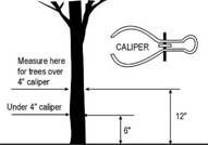
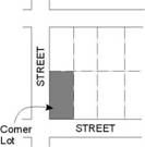
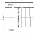
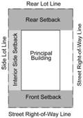

20-1718 Construction Sales and Services
Construction activities and incidental storage on Lots other than
construction sites. Also includes landscape contractors and landscape
maintenance businesses and the retail or wholesale sale, from the Premises, of materials
used in the construction of Buildings
or other Structures
not including the retail sale of paint, fixtures, and hardware, but
excludes those uses classified as "Automotive" and/or "Heavy
Equipment" use types. Typical uses include Home Improvement or Building materials
stores, tool and equipment rental or sales, Building contracting/construction offices with
shops and/or outside storage yards and landscape maintenance/contractor offices
with shops and/or outside storage yards.
20-1725 Entertainment and Spectator Sports
Provision of cultural, entertainment, athletic, and
other events to spectators. Also includes events involving social or fraternal
gatherings. For participant sports, see Sec. 20-1764 20-1762.
The following are spectator sports and entertainment use types:
(4) Limited
Those uses conducted within an enclosed Building with a capacity of 500 or less people. Typical uses include small theaters and meeting halls.
(5) General
Those uses generating an attendance of 501 or more people such as theaters (movie or legitimate), large exhibition halls, field houses, stadiums and sports complexes.
20-1752 Recycling Facilities
Collection A facility for the
collection and/or processing of Recyclable Materials. A recycling facility
does not include storage containers or processing activity located on the Premises of a
residential, commercial, or manufacturing use and used solely for the recycling
of material generated by that residential property, business or manufacturer.
Recycling facilities may include the following:
(1)
Large Collection Facilities
A center for the acceptance by
donation, redemption, or purchase, of Recyclable Materials from the public occupying
an area of more than 500 square feet, which may or may not include permanent Structures.
(2)
Small Collection Facilities
A center or facility for the
acceptance by donation, redemption, or purchase, of Recyclable Materials from the public occupying
an area of no more than 500 square feet, and may include:
(3) Collection Facilities
A center or facility for the acceptance by donation, redemption, or purchase of Recyclable Materials from the public. A Small Collection Facility may occupy a maximum area of 500 square feet. Large Collection Facilities may occupy a greater land area. Both facilities may include:
(i)
Recycling mobile collection unit, being an automobile,
truck, trailer or van, or roll-off container that is used for the collection of
Recyclable Materials.
A mobile recycling unit also means the bins, boxes or containers transported by
trucks, vans, or trailers used for the collection of Recyclable Materials.
Attended or unattended mobile collection units such as all-weather
roll-off containers, bins or boxes, which are not permanently affixed to the
ground;
(ii)
Reverse vending machines;
(iii)
Kiosk-type units that may include permanent Structures;
(ii) Reverse vending machines or kiosks that may include permanent structures;
(iii)
Unattended containers placed for the donation of Recyclable Materials;
and
(iii) Indoor facilities, ancillary to the primary activity of a business or organization.
(4) Processing Center
A Building or enclosed space used for the collection and processing of Recyclable Materials. Processing means the preparation of material for efficient shipment, or to an end-user's specifications, by such means as baling, briquetting, compacting, flattening, grinding, crushing, mechanical sorting, shredding, cleaning, and remanufacturing.