|
PLANNING COMMISSION REPORT Regular Agenda – Public Hearing Item: |
|
PC Staff Report 03/26/07 |
|
ITEM NO. 9: SPECIAL USE PERMIT FOR NEXTEL COMMUNICATIONS CELLULAR TOWER, 2101 WAKARUSA DRIVE (MKM)
SUP-01-01-07: Special Use Permit for a Nextel Communications cellular tower, located at 2101 Wakarusa Drive. Submitted by Ward Development Services and WFI, Inc., for the City of Lawrence, property owner of record. |
|
STAFF RECOMMENDATION: Planning Staff recommends approval of SUP-01-01-07, a Special Use Permit for the construction of a tower and placement of antenna and ground mounted equipment at 2101 Wakarusa Drive and forwarding of it to the City Commission with a recommendation for approval, based upon the findings presented in the body of the staff report and subject to the following conditions:
1. Execution of a site plan performance agreement. 2. Execution of a land lease agreement with the City of Lawrence, prior to the release of the site plan for issuance of a building permit. 3. Completion of the independent review per City Code section 20-529 confirming that the applicant has met the Burden of Proof regarding co-location prior to consideration of the Special Use Permit by the City Commission. 4. Provision of a revised site plan with the following changes: a. Book and Page number for recorded access/utility easement referenced on the plan b. Note added referencing applicant’s agreement with City to mount security camera equipment and communication equipment on the tower for the City facilities on the site. c. Note stating; “The tower must either have a galvanized finished or be painted gray or light blue per Section 20-529(2) (v) of the Development Code.” d. Note stating “The tower construction will comply with Section 20-529 of the City Code so that if a failure does occur, the tower will collapse into itself.” |
|
Applicant’s Reason for Request: |
“To construct a 150-foot monopole cellular communication tower to expand and enhance its existing network in the Douglas county area. Nextel currently has a lack of coverage in the southwestern portion of Lawrence as indicated by the enclosed propagation maps. Nextel has performed several structural analysis of the existing tower to review different antenna configurations, all of which have been unsuccessful. The tower will be located in an industrial area and will be available for co-location.” |
|
KEY POINTS · UPR-12-07-03; a Use Permitted upon Review was approved by the City Commission on Feb 17, 2004 for a tower at this location. The tower was not constructed within the time frame permitted in the UPR so it expired. · A 20’ wide access/utility easement will provide access to the towers from the south from the Fire Station site and will eliminate the need to access the towers through the water treatment plant. |
|
GOLDEN FACTORS TO CONSIDER
Zoning and uses of property nearby The subject property, approximately 118 acres, is zoned GPI (General Public Institution) District. This property contains the Clinton Water Treatment Plant, Fire Station #4, undeveloped land, and about 24.5 acres of woodland planned for a future City park.
The property located to the west is outside the City limits and contains Lake Alvamar, a 56-acrelake, constructed as a watershed drainage project. This property is zoned A (Agricultural) District.
South of the subject property is a Planned Commercial Development [Wakarusa Center] PD, which contains a nursery and garden store, a mini-storage facility, and a car wash. A multi-family development which is zoned RM12 (Multi-dwelling Residential) District is also located to the south of the subject property. The proposed use is located on the southern side of the subject property housing the Clinton Water Treatment facility and City Fire Station #4.
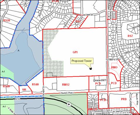
There are several zoning districts located north of the subject property. An IBP (Industrial Business Park) District is located north of the subject property with assorted office uses (primary medical and financial), and a RS7 (Single-dwelling Residential) District with single family homes is located to the west of this district. In the northwest corner, north of the future City parkland, is a RS10 (Single-dwelling Residential) District which contains open space and a pond with single family homes to the north. Wakarusa Drive is located east of the subject property and a RMO (Multi-dwelling Residential-Office) District with townhomes is located on the east side of Wakarusa Drive. North of the RMO District is a RS7 (Single-dwelling Residential) District with single family homes. Figure 1
Character of the area The area is characterized by a variety of surrounding uses with a significant amount of open/green space. Approximately 115 acres of open/green space in the form of the Yankee Tank Creek area (approximately 86 acres including a lake) and the future city park land (approximately 25 wooded acres) is located to the west and north of the subject area. Development in the area consists primarily of general public uses (water treatment facility and fire station), multi-dwelling residences (with some office uses), commercial uses to the south, and office uses to the north. Single-dwelling residences are located in the area and are generally located to the north of the City property and to the east of Wakarusa Drive.
|
|
ASSOCIATED CASES/OTHER ACTION REQUIRED · Determination from the independent review firm that the applicant met the Burden of Proof. (In process) · Approval of the Special Use Permit by the City Commission. · Recording of access/utility easement. · Publication of Special Use Permit ordinance. · Execution of a lease agreement with the City of Lawrence.
|
|
PUBLIC COMMENT RECEIVED PRIOR TO PRINTING · No comment on this item at this time.
|
GENERAL INFORMATION |
|
|
Current Zoning and Land Use:
|
GPI (General Public and Institutional) District; City property housing a Fire/Medical Station, Clinton Water Treatment Facility, communication tower and future City parkland.
|
|
Surrounding Zoning and Land Use: |
To the south: PD [Wakarusa Center] District; Planned Commercial District including a carwash, mini-storage and nursery/garden center.
To the west: A (Agricultural) District; property outside the City limits. Alvamar Lake .
To the east: RMO (Multi-Dwelling Residential-Office) and RS7 (Single-Dwelling Residential) Districts; residential uses.
To the north: IBP (Industrial Business Park) District; Offices, including medical, veterinary and real estate. |
|
Site Summary |
|
|
Parent Parcel: |
118.12 acres; 50’ x 50’ lease area in the southern portion of the parent parcel. |
|
Proposed Tower: |
150’ cellular communication tower |
|
Proposed structure type:
Ground Equipment: |
150’ monopole tower designed for Nextell antenna array and 3 additional carrier platforms. 11.5’ x 20’ shelter building; pad mounted transformer located in the 20’ utility/access easement next to the lease property. |
Review and Decision-Making Criteria (20-1306(i))
1. WHETHER THE PROPOSED USE COMPLIES WITH ALL APPLICABLE PROVISIONS OF THIS DEVELOPMENT CODE
Communication towers are permitted by right in the GPI District as an Accessory use per Use Table, Section 20-403. Section 20-529(9)(iii) states that telecommunication towers shall not be located within ½ mile of another telecommunication tower, except when the two are on the same site and the second telecommunication tower is approved with a Special Use Permit.
Staff Finding – The proposed use is consistent with applicable provisions of the Development Code.
2. WHETHER THE PROPOSED USE IS COMPATIBLE WITH ADJACENT USES IN TERMS OF SCALE, SITE DESIGN, AND OPERATING CHARACTERISTICS, INCLUDING HOURS OF OPERATION, TRAFFIC GENERATION, LIGHTING, NOISE, ODOR, DUST AND OTHER EXTERNAL IMPACTS
The subject property is located in an area that includes multiple land uses and a variety of zoning districts. The proposed use is located near an existing communication tower which will minimize the amount of visual impact on the area. The towers will be aligned east and west, so the view will change only slightly from the residential neighborhoods to the east and west. The visual impact will be more significant when viewed from the north and south, where the commercial and office uses are located. The tower lighting is not required for the FAA. There will be no other external impacts anticipated with this development. The applicant is reserving the right to install a generator in the accessory shelter, although one will not be installed at this time.
Staff Finding – Approval of the Special Use Permit does not alter the base zoning district. The proposed use, with conditions is compatible with the adjacent uses.
3. WHETHER THE PROPOSED USE WILL CAUSE SUBSTANTIAL DIMINUTION IN VALUE OF OTHER PROPERTY IN THE NEIGHBORHOOD IN WHICH IT IS TO BE LOCATED
The tower is being located in a GPI (General Public Institution) District adjacent to an existing tower. The visual impact will be minimized by the arrangement of the towers and the institutional nature of uses for the overall property. The amount of change in property value from the existence of a communication tower, or improved cellular coverage is difficult to gauge.
Staff Finding –In Staff’s opinion, the addition of this communication tower will not cause substantial diminution in property value of other property in the neighborhood.
4. WHETHER PUBLIC SAFETY, TRANSPORTATION AND UTILITY FACILITIES AND SERVICES WILL BE AVAILABLE TO SERVE THE SUBJECT PROPERTY WHILE MAINTAINING SUFFICIENT LEVELS OF SERVICE FOR EXISTING DEVELOPMENT
Communication towers are a low-intensity use which require very little transportation and utility services/facilities. A transformer is being located in a utility easement next to the tower for power supply. Access to the communication tower location is being revised by the City Utility Staff as a result of planned improvements to the water treatment facility that will make the current access restricted. The new access will be provided from the rear of the Fire Station #4 parking area which was designed with this improvement anticipated.
Staff Finding – Public safety, transportation and public utilities established to provide service to the area are adequate for this use. The site is not intended for access by the general public.
5. WHETHER ADEQUATE ASSURANCES OF CONTINUING MAINTENANCE HAVE BEEN PROVIDED
Staff Finding –Adequate assurances have been provided as the SUP site plan lists the telecommunication facilities maintenance requirements set out in Section 20-519 (3) of the Development Code as requirements of this Special Use Permit.
6. WHETHER THE USE WILL CAUSE SIGNIFICANT ADVERSE IMPACTS ON THE NATURAL ENVIRONMENT
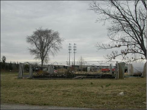
There is a significant amount of open/natural space in the vicinity of the proposed tower. County land containing Lake Alvamar is located to the west of the subject property and future City parkland is located on the west side of the subject property. Per Section 20-529(2) (v), all telecommunications facilities are required to be sited to have the least visual effect as practical on the environment. The tower must have a galvanized finish or be painted gray or light blue to reduce the amount of visual impact. The previous tower request for this location had received some opposition based on the visual impact of siting the 2 towers together. The applicant stated they could move the tower further to the west; however in Staff’s opinion more widely separated towers would have a greater negative visual impact and would be less compatible with the natural environment as they would require additional access roads and utility easements for extension of services. Figure 2. The applicant indicated that the less obtrusive ‘stealth’ towers would not meet their coverage needs. The tower is a mono-pole design which is more compatible with the natural environment than a guyed tower.
Staff Finding – In Staff’s opinion, the proposed tower will not cause significant adverse impacts on the natural environment and the proposed location of the tower will minimize any adverse impacts. A note must be added to the site plan regarding the towers appearance. Staff recommends as a condition of approval the site plan be revised to include the following note: “The tower must either have a galvanized finished or be painted gray or light blue per Section 20-529(2) (v) of the Development Code.”
7. WHETHER IT IS APPROPPRIATE TO PLACE A TIME LIMIT ON THE PERIOD OF TIME THE PROPOSED USE IS TO BE ALLOWED BY SPECIAL USE PERMIT AND, IF SO WHAT THAT TIME PERIOD SHOULD BE.
The Development Code sets a time requirement for communication towers that are no longer used in Section 20-529(3)(i). Towers that are not in use for 3 full years or more shall be removed. It would not be appropriate to place a time limit on the tower when it is in use as additional facilities are being sited based on this location. Requiring the tower use to be discontinued at a specific time in the future would require additional towers to be located in the area for the continued provision of communication services. As co-location is required on towers, the required discontinuation of the tower use would cause significant disruption for multiple communication carriers.
Staff Finding –In Staff’s opinion it would not be appropriate to limit the time the use shall be permitted, beyond that included in the Development Code for abandoned towers.
SITE PLAN/STAFF REVIEW
The subject property is a portion of City-owned property located on the west side of Wakarusa Drive. The applicant is seeking a lease agreement with the City for a 50’x50’ site located to the west of the existing tower site.
Development History: A proposal to locate a tower in this location was made in 2003 and a Use Permitted upon Review (UPR) was recommended for approval by the Planning Commission by a vote of 8 to 1 and unanimously approved by the City Commission on February 17, 2004. The tower was not built within the time limit and the UPR approval expired. The current proposal is similar to the previous, with the exception that it is smaller, includes improved access for it and the existing tower facility and includes provisions to locate City communication units on the tower.
Zoning: The subject property is zoned GPI (General Public Institutional) District. The proposed request is consistent with other communication requests and applications for use of public property.
Use: The subject property is primarily used for public institutional uses. A fire station and a City water treatment facility are currently located on this site as well as a City Public Works fueling station at the north end of the property. A city park is proposed for the western portion of the property. The applicant’s reports indicate that the existing tower at this site is at capacity and co-location on this tower is not possible. The applicant has provided the fee for the independent review as required by Section 20-529(6). A consultant is being selected to review the applicant’s request and determine if the Burden of Proof regarding the possibility of co-location has been satisfied. Section 20-529(7) of the Code states that “No new telecommunications tower shall be permitted unless the applicant demonstrates to the reasonable satisfaction of the City that no existing telecommunications tower or other structure can accommodate the applicant’s proposed telecommunications antenna.” This determination is required as a condition of approval for this SUP and must be completed prior to the application being considered by the City Commission.
The site plan shows that access will be taken from Wakarusa Drive through an extension of the fire station access. A 20’ wide access and utility easement is proposed that will accommodate a 12’ wide access drive. A pad will be constructed along the south side of the facilities which will allow each tower facility access to the drive. This new access will eliminate the need for the tower and the existing tower to access their facilities through the Clinton Water Treatment Plant which will increase the security of the water treatment facility. The leased area is proposed to be screened with white pine trees to provide year-round screening.
The tower will be able to provide 4 co-locations, including the applicant, with multiple antennae for each provider. The applicant indicated they have an agreement to mount security camera equipment and communication equipment on the tower for the City facilities on the site. A note referencing this agreement must be included on the site plan.
Section 20-529 requires that all telecommunication towers be constructed so that if a failure does occur, the tower will collapse into itself. A note indicating that this type of construction will be utilized for this tower must be added to the site plan and is reflected as a condition of approval.
The single family neighborhood to the east is developed at a higher elevation that the area west of Wakarusa Drive. Many residences have a clear view of the subject area especially from rear yards. This section of Wakarusa Drive is typified by 6’ wood screening fences along the public right-of-way. As the tower is to be located almost directly to the west of the existing tower, the addition of the proposed tower should not increase the visual impact of the commercial/institutional area on this neighborhood.
|
|
Figure 1. General land use of surrounding area.
|
|
|
|
Figure 2. Simulated view of 2 towers at full capacity from the south.
|