|
PLANNING COMMISSION REPORT Consent Agenda - Non-Public Hearing Item |
PC Staff Report
08/23/06
ITEM NO. 4: FINAL PLAT FOR OREGON TRAIL ADDITION; N OF US HWY 40 & E OF GEORGE WILLIAMS WAY (MKM)
PF-07-17-06: Final Plat for Oregon Trail Addition. The property is located North of U.S. Hwy 40 (6th Street) and East of George Williams Way (extended). This residential subdivision contains 123 single-family and multi-family residential lots. Submitted by Landplan Engineering, for Oregon Trail Holdings LC, property owner of record.
|
STAFF RECOMMENDATION: Planning staff recommends approval of the Final Plat for the Oregon Trail Addition and forwarding it to the City Commission for acceptance of easements and rights-of-way, subject to the following conditions: 1. Revision of the final plat to include the following: a. A note stating “No building permits will be issued until the completion of George Williams Way, Stoneridge Drive or Overland Drive to serve the subdivision.” b. A note stating: “Building permits issued within this subdivision shall be limited to a maximum number of dwelling units (based upon an updated revised Traffic Impact Study showing only one access into the subdivision with Level of Service of “C: or better, at the intersection of George Williams Way and W. 6th Street, or Stoneridge Drive and W. 6th Street) until such time as a second access to the subdivision is completed.” c. 10’ landscape easements must be provided on the rear of double frontage lots. d. Pedestrian easements provided in Block Three between Lots 26 & 27 and along the southern border of Tract ‘A’ and continuing on between Lots 5 & 6, all of Block Three. 2. Provision of the following fees and documentation: a. Recording fees made payable to the Douglas County Register of Deeds. b. A completed and revised Master Street Tree Plan with Red Maple deleted and Zelkova (Botanical name: Zelkova serata ‘Green Vase’) added. c. A Temporary Utility Agreement. d. Street sign fees. 3. Pinning of lots in accordance with Section 21-302.2 of the Subdivision Regulations. 4. Submission of public improvement plans prior to the recording of the Final Plat with the Register of Deeds Office. 5. Final
Plat can |
|
Applicant’s Reason for Request: |
To develop a 123 lot residential subdivision of single-family, duplex and multi-family residences. |
|
KEY POINTS · Sanitary sewer capacity is being worked out between the City Utilities Engineer and the Developer. Sanitary Sewer plans will be submitted and approved before the final plat will be recorded. · Rezoning requests for this property [Z-09-46-04, Z-09-47-04, and Z-09-48-04] from A (Agricultural) to RS-2 (Single-Family Residence), RM-1 (Multi-Family Residence) and RM-D (Multi-Family Duplex) Districts were approved by the City Commission on November 16, 2004. The rezoning approval is contingent on the filing of the final plat. · These rezoning classifications converted with the implementation of the Land Development Code. The zoning classifications listed in this table will reflect the zoning classifications under the Land Development Code, effective as of July 1, 2006. |
|
ASSOCIATED CASES/OTHER ACTION REQUIRED · PP-12-28-04: Preliminary Plat of Oregon Trail Addition, approved by Planning Commission January 24, 2005. · One-year time extension for the Preliminary Plat for the Oregon Trail Addition approved by the Planning Commission on November 14, 2005. · May 23, 2006 modifications to the street access conditions of the Preliminary Plat approved by Planning Commission. · Rezoning requests for this area [Z-09-46-04, A to RM-1; Z-09-47-04, A to RS-2, and Z-09-48-04, A to RM-D] were approved by the City Commission on November 16, 2004, contingent on filing of final plat. · Acceptance of easements and rights-of-way by the City Commission. · Recordation of the final plat at the Register of Deeds Office. · Publication of zoning ordinances for the pending rezonings. |
GENERAL INFORMATION
|
Current Zoning and Land Use: |
UR (Urban Reserve) District; Pending rezonings of RS7 (Single-Dwelling Residential), RM12 (Multi-Dwelling Residential), and RM12D (Multi-Dwelling Residential) District; undeveloped agricultural land
|
|
Surrounding Zoning and Land Use: |
UR (Urban Reserve) District to the west; Pending rezonings of PCD [Mercato], RMO (Multi-Dwelling Residential-Office),RS7(Single-Dwelling Residential), RM24 (Multi-Dwelling Residential) and RM12D (Multi-Dwelling Residential-Duplex) Districts.
UR (Urban Reserve) and RS10 (Single-Dwelling Residential) Districts to the south; undeveloped land and a church.
A (Agricultural) District to the north; property outside the City limits with agricultural uses and wooded areas.
|
Site Summary
Number of lots proposed: 123 Lots
Minimum Lot area: 8,012 sq. ft
Maximum Lot area: 446,746 sq. ft
Average Lot area: 15,261 sq. ft.
Tract A: 127,150 sq. ft
Rights-of-way: 60’ of right-of-way is being dedicated for the interior streets of Three Forks Drive, Freemont Drive, Headwaters Drive, Fort Benton Way, Fort Benton Drive, Fort Laramie Drive, Freemont Way, Three Forks Court, and Chimney Rocks Circle.
80’ of right-of-way is dedicated for Overland Drive.
40’ right-of-way is being dedicated for approximately 700’ from the east property line along the northern edge of the property for Stoneridge Drive.
STAFF REVIEW
The request is for approval of a 123 lot subdivision to allow development of single-family, duplex, and multi-family residences. The multi-family portion of this development will require site-planning. The subject property is located north of W 6th Street and to the east of George Williams Way (extended). Overland Drive will be extended to connect this area with developments (Mercato and Loges Addition) to the west and east. The Preliminary Plat for Oregon Trail Addition was approved by the Planning Commission in 2005 and an extension was granted to January 2007.
Street and Access
The development will take access from W 6th Street by the extension of George Williams Way. George Williams Way has not yet been constructed and is designated as a minor arterial in Transportation 2025. Overland Drive, shown as a collector on the Major Thoroughfares Map, will be extended to connect this development with the Mercato Addition to the west and the Loges Addition to the east. Fort Benton Drive will be extended from the Loges Addition to the east to provide additional access into the development. The final plat has blanks for the Book and Page reference for right of way dedication along George Williams Way. A Benefit District is being formed by property owners in this area for the construction of George Williams Way and right-of-way acquisition will occur through the benefit district; therefore, the Interim City Manager has determined that Book and Page reference for off-site dedication of right-of-way for George Williams Way will not be required.
A condition on the Preliminary Plat was that a note would be added stating “No building permits will be issued until the completion of either George Williams Way, Stoneridge Drive or Overland Drive to the subdivision.” This condition has been carried forward to the final plat, with the revision that the roads must be completed to serve the subdivision rather than just to the subdivision.
The Preliminary Plat also had a note stating “Building permits issued within this subdivision shall be limited to a maximum number of dwelling units (based upon an updated revised Traffic Impact Study showing only one access into the subdivision with Level Of Service of “C” or better, at the intersection of George Williams Way and W. 6th Street, or Stoneridge Drive and W. 6th Street) until such time as a second access to the subdivision is completed.” A revised TIS has been submitted and is currently under review by the City Engineer. The number of building permits issued within this subdivision with only one access shall be determined as a result of her review. This note is being carried over to the final plat due to the fact that the review of the revised TIS is not complete.
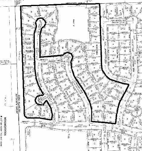
To improve connectivity and walkability from the east and west sides of the development, pedestrian easements are recommended. Section 21-609(c) states “Pedestrian-way easement for pedestrian use may be required when a block exceeds 800 feet in length. Such easement shall extend entirely across the width of the block at approximately its midpoint. It shall have a minimum width of 10 feet.” Block Three is irregularly shaped and has several legs longer than 800’. (see figure 1) While a pedestrian easement is provided between Lots 37 and 38 of Block Three, an additional pedestrian easement through Block Three at the cul-de-sac of Freemont Way would increase the walkability of the area. If Tract A has adequate area to be used as open space, a pedestrian easement connecting the cul-de-sac of Freemont Way to Tract A, the drainage easement, could provide access to that open space. An easement could be provided between Lots 27 and 26 of Block Three which could cut across the southeastern corner of Tract ‘A’ and continue between Lots 5 and 6 of Block Three to reach Headwaters Drive. This would provide access from Headwaters Drive to Freemont Drive and the open space of Tract ‘A’.
Staff is recommending these pedestrian easements be provided to allow access from Headwaters Drive to Freemont Way through Block Three and to provide access to the open space in Tract A if the size and nature of the area would provide quality open space.
Utilities and Infrastructure
The Developer and City Utility Department are continuing to work on sanitary sewer capacity. The proposed development includes area that is not in the Pump Station (PS) 45 Benefit District, yet proposes utilizing the facility. Sanitary Sewer Plans must be submitted to the City Utility Department and approved before the final plat is filed. Water line plans must be provided to the City Utility Department. The plans must be submitted for approval and signatures from the fire and utilities departments before building permits are issued.
Stormwater Drainage
The stormwater drainage study and the stormwater features on the final plat have been approved by the City Stormwater Engineer. A private drainage easement is located along the north property line. Several drainage easements are located in the plat. The Minimum Elevation of Building Opening (MEBO) must be provided for all lots adjacent to a drainage easement. MEBOs must be listed for Lots 3, 4, 10, and 11 of Block Two; Lots 38 and 39 of Block Three; Lots 7, 8, 9 and 10 of Block Five and any other lots which are adjacent to drainage easements.
Easements
The City Landscape Supervisor had requested that the front utility easements be reduced to facilitate the planting of street trees; however, the 10’ and 15’ easements are needed to accommodate sanitary sewer lines. The City Utilities Engineer indicated that some utility easements along the front property lines may not be required, but this would not be known until the sanitary sewer plans were approved.
Street trees will need to be planted in both the front and rear yards of the double frontage lots. These double frontage lots are located between Three Forks Drive and George Williams Way on the west side of the development, and between Chimney Rocks Circle and Stoneridge Drive on the southeast. (see Figure 2) A landscape easement along the rear of these lots will insure space will be available for street trees. Utility easements can be shown to cross the landscape easement where necessary.
Additional pedestrian easements linking Headwaters Drive to Freemont Way through Block Three, and providing access to the open space in Tract A (if this tract is of adequate area and nature to provide quality open space) are recommended by Staff.
Summary
The proposed subdivision is in conformance with the minimum lot area and dimension requirements for the RS7 (Single-Dwelling Residential), RM12 (Multi-Dwelling Residential), and the RM12D (Multi-Dwelling Residential Duplex) Districts. The plat is in conformance with the Land Development Code. Staff recommends additional pedestrian easements to increase walkability and connectivity of the area and landscape easements along the rear of the double frontage lots to accommodate the planting of street trees.
In accordance with Section 21-302.2, the lots will need to be pinned as a condition of plat approval.
1270’ Figure 1. Block 3 and Pedestrian Easements. Block 3 is outlined, with
approximate dimensions shown. Solid gray
line is easement being provided. Dashed line
is additional recommended easements. 1105’
![]()
![]()
![]()
![]()


![]()
![]()

 |