RESOLUTION NO. 6698
A RESOLUTION DIRECTING AND ORDERING A PUBLIC HEARING ON THE ADVISABILITY OF THE CONSTRUCTION OF A PUBLIC PARK, INCLUDING PARK FACILITIES AND EQUIPMENT, RECREATION PATHS, STORMWATER IMPROVEMENTS AND OTHER NECESSARY AND APPROPRIATE IMPROVEMENTS APPURTENANT THERETO, PURSUANT TO K.S.A. 12-6a01 ET SEQ.
BE IT RESOLVED BY THE GOVERNING BODY OF THE CITY OF LAWRENCE, KANSAS:
Section 1.
That a public hearing shall be held by the Governing Body of the City of Lawrence, Kansas, on the advisability of the following improvement:
THE CONSTRUCTION OF A PUBLIC PARK, INCLUDING PARK FACILITIES AND EQUIPMENT, RECREATION PATHS, STORMWATER IMPROVEMENTS AND OTHER NECESSARY AND APPROPRIATE IMPROVEMENTS APPURTENANT THERETO.
(the “Improvements”).
Section 2.
Said hearing shall be held on the 27th day of February, 2007, in the City Commission meeting room, City Hall, 6 East 6th Street, Lawrence, Kansas, at 6:35 p.m. or thereafter as provided by K.S.A. 12-6a01 et seq.
Section 3.
The City Clerk shall cause the following notice of such public hearing to be published in the official city newspaper at least once each week for two consecutive weeks prior to the hearing.
NOTICE OF PUBLIC HEARING
Notice is hereby given that the Governing Body of the City of Lawrence, Kansas, will meet for the purpose of holding a public hearing as provided by K.S.A. 12-6a01 et seq. in the City Commission meeting room, City Hall, 6 East 6th Street, Lawrence, Kansas on the 27th day of February, 2007, at 6:35 p.m. or thereafter as provided by K.S.A. 12-6a01 et seq., to consider the advisability of the following proposed improvement, to-wit:
(a) The general nature of the proposed improvement:
THE CONSTRUCTION OF A PUBLIC PARK, INCLUDING PARK FACILITIES AND EQUIPMENT, RECREATION PATHS, STORMWATER IMPROVEMENTS AND OTHER NECESSARY AND APPROPRIATE IMPROVEMENTS APPURTENANT THERETO.
(the “Improvements”).
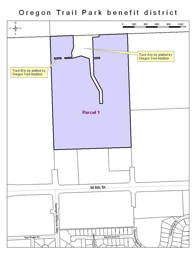
(b) The proposed improvement district shall consist of those tracts of land shown on the map attached hereto as Exhibit A, and legally described as follows:
Parcel 1 – Douglas County Plate No. U13969B - Oregon Trail Holdings, LC (to be platted as Oregon Trail Addition: A Subdivision of the City of Lawrence, Kansas).
A TRACT OF LAND IN THE SOUTHEAST QUARTER OF SECTION 29, TOWNSHIP 12 SOUTH, RANGE 19 EAST OF THE SIXTH PRINCIPAL MERIDIAN, IN DOUGLAS COUNTY, KANSAS, DESCRIBED AS FOLLOWS:
BEGINNING AT A POINT ON THE WEST LINE, 690.00 FEET NORTH OF THE SOUTHWEST CORNER OF SAID QUARTER SECTION; THENCE NORTH 01°59'09" WEST, ALONG SAID WEST LINE, 1962.89 FEET TO THE NORTHWEST CORNER OF SAID QUARTER SECTION; THENCE NORTH 88°03'58" EAST, ALONG THE NORTH LINE OF SAID QUARTER SECTION, 1338.11 FEET TO THE NORTHEAST CORNER OF THE WEST ONE HALF OF SAID QUARTER SECTION; THENCE SOUTH 02°01'38" EAST, ALONG THE EAST LINE OF SAID WEST ONE HALF, 1963.13 FEET; THENCE SOUTH 88°04'34" WEST, 1339.53 FEET TO THE POINT OF BEGINNING. CONTAINS 60.333 ACRES, MORE OR LESS.
LESS THE FOLLOWING DESCRIBED TRACTS:
BEGINNING AT A POINT ON THE NORTH LINE, 398.76 FEET EAST OF THE NORTHWEST CORNER OF THE SOUTHEAST QUARTER OF SECTION 29, TOWNSHIP 12 SOUTH, RANGE 19 EAST OF THE SIXTH PRINCIPAL MERIDIAN; THENCE NORTH 88°03’58” EAST, ALONG SAID NORTH LINE, 449.44 FEET; THENCE SOUTH 02°01’39” EAST, 40.00 FEET; THENCE SOUTH 88°03’58” WEST, 115.00 FEET; THENCE SOUTH 02°01’39” EAST, 353.36 FEET; THENCE NORTH 87°58’21” EAST, 115.00 FEET; THENCE SOUTH 02°01’39” EAST, 20.00 FEET; THENCE SOUTH 87°58’21” WEST, 115.00 FEET; THENCE SOUTH 02°01’39” EAST, 287.73 FEET; THENCE SOUTH 28°44’07” EAST, 299.26 FEET; THENCE SOUTH 01°59’02” EAST, 225.62 FEET; THENCE ON A 1240.00 FOOT RADIUS CURVE TO THE LEFT WITH A 50.32 FOOT CHORD BEARING NORTH 85°29’49” WEST, AN ARC DISTANCE OF 50.33 FEET; THENCE NORTH 01°59’02” WEST, 208.05 FEET; THENCE NORTH 28°44’07” WEST, 298.53 FEET; THENCE NORTH 05°54’22” WEST, 308.66 FEET; THENCE NORTH 71°48’33” WEST, 141.79 FEET; THENCE SOUTH 75°19’03” WEST, 167.99 FEET; THENCE SOUTH 88°00’51” WEST, 125.83 FEET; THENCE NORTH 01°59’02” WEST, 20.00 FEET; THENCE NORTH 88°00’51” EAST, 123.66 FEET; THENCE NORTH 01°59’09” WEST, 90.00 FEET; THENCE NORTH 21°37’04” EAST, 87.30 FEET; THENCE NORTH 01°59’02” WEST, 204.02 FEET TO THE POINT OF BEGINNING. CONTAINS 4.282 ACRES, MORE OR LESS.
ALSO:
BEGINNING AT A POINT WHICH IS NORTH 88°03’58” EAST, 60.00 FEET ALONG THE NORTH LINE, AND SOUTH 01°59’09” EAST, 374.33 FEET FROM THE NORTHWEST CORNER OF THE SOUTHEAST QUARTER OF SECTION 29, TOWNSHIP 12 SOUTH, RANGE 19 EAST OF THE SIXTH PRINCIPAL MERIDIAN; THENCE NORTH 88°00’51” EAST, 120.14 FEET; THENCE SOUTH 01°59’02” EAST, 20.00 FEET; THENCE SOUTH 88°00’51” WEST, 120.14 FEET; THENCE NORTH 01°59’09” WEST, 20.00 FEET TO THE POINT OF BEGINNING. CONTAINS 0.055 ACRE, MORE OR LESS.
(c) The estimated or probable cost of the improvements is $811,000 (to be increased at the pro-rata rate of 1 percent per month from and after the adoption date of the resolution authorizing the Improvements), plus costs of issuance and plus costs of interest on any temporary financing.
(d) The method of assessment:
Each lot and parcel within the improvement district shall be assessed based on a ratio of the square footage of each lot or parcel to the square footage of the entire improvement district.
(e) Apportionment of costs:
One hundred percent (100%) of the cost of the improvement shall be assessed to the improvement district and zero percent (0%) of the cost of the improvement shall be paid by the City-at-large.
(f) Pursuant to K.S.A. 12-692, the governing body may exempt, in whole or in part, certain property from special assessments made to pay the costs of acquiring land necessary for the construction of the improvements, the owner or owners or predecessors in title to which have dedicated or conveyed property necessary for the stormwater improvements. It is the intent of the governing body to require properties that have not dedicated the necessary property for the stormwater improvements to bear the cost of acquiring such property.
The hearing may be adjourned from time to time and until the Governing Body shall have made findings by resolution as to the advisability of the improvement, the nature of the improvement, the estimated cost, the boundaries of the improvement district, the method of assessment and the apportionment of cost between the improvement district and the city-at-large, all as finally determined by the governing body.
ADOPTED by the governing body of the City of Lawrence, Kansas, this 6th day of February, 2007.
PASSED:
______________________________
Mike Amyx, Mayor
ATTEST:
____________________________
Frank S. Reeb, City Clerk Date
Approved as to form and legality:
_______________________________
Toni Wheeler Date
Interim Director of Legal Services
Legal description approved by:
______________________________
Charles F. Soules, P.E. Date
Director of Public Works
Exhibit A