|
PLANNING COMMISSION REPORT SUMMARY Regular Agenda -Public Hearing Item
|
|
ITEM NO. 5: REVISED PRELIMINARY DEVELOPMENT PLAN FOR ABERDEEN ON 6TH ST; SE CORNER OF W 6TH ST & STONERIDGE DR (SLD)
PDP-01-02-06: Revised Preliminary Development Plan for Aberdeen on 6th Street. This proposed multi-family planned residential development contains 108 proposed apartment units and including four duplex units on approximately 9.59 acres. The property is generally described as being located at the southeast corner of W. 6th Street and Stoneridge Drive. Submitted by Landplan Engineering for MS Construction Co., Inc., property owners for record. This item was deferred from the July Planning Commission meeting.
|
|
STAFF RECOMMENDATION: Planning staff recommends approval of the revised Preliminary Development Plan for Aberdeen on Sixth based upon the findings of fact presented in the body of the Staff Report and forwarding it to the City Commission with a recommendation for approval subject to the following conditions:
1. Provision of a revised Preliminary Development Plan to show a restricted gate along Winthrop Court per City Fire and Public Works staff approval. 2. Provision of a note that states access gate shall be for emergency purposes only. General vehicular access immediately to Stonecreek Drive from the development shall be prohibited. 3. Execution of an agreement not to protest the formation of a benefit district for intersection and geometric improvements to W. 6th Street and Stoneridge Drive. 4. Provision of a revised Preliminary Development Plan that shows installation of larger size (10 gallon minimum size) planting along the south side of the development for lots that abut Stonecreek Drive per staff approval. 5. Provision of a note on the face of the Preliminary Development Plan that states: “The Final Development Plan shall include specific building elevations that note building materials to be used for roof, siding, and facing elements visible from the public streets and viewable from abutting properties.”
|
|||
|
Applicant’s Reason for Request: |
Multi-Family Residential development.
|
||
|
KEY POINT · Property initiated for Planned Residential Development by Planning Commission. · Property abuts an arterial and collector street on the north and west and a local street on the south. · Development abuts platted single-family residential lots on the south side. · Development plan includes duplex units along the local street and 8 plex units interior to site with one and two bedroom units. |
|||
|
FACTORS TO CONSIDER · Conformance with transition requirements of development. · Additional development actions are required: recording of final plat, publication of zoning ordinances, submission and approval of a Final Development Plan and provision of public improvement plans.
|
|||
|
ASSOCIATED CASES/OTHER ACTION REQUIRED 1. Recording of PF-08-28-05; Stoneridge East. Approved by the City Commission 11/8/05 · Consideration of Final Plat by City Commission to reconsider vacation of right-of-way for Winthrop Court. 2. Publication of Z-03-19-05: A to RS-2; 4.9 acres. Pending recording of Final Plat. [Original submittal came as RM-D but revised by applicant following neighborhood meetings to single-family (RS-2).] 3. Publication of Z-03-20-05 A to RM-1; 7.4 acres – Lesser changed to PRD-2 with restrictions 4. Publication of Z-03-21-05 A to RM-2; 4.2 acres – Lesser changed to PRD-2 (Planned Residential District) recommended by Planning staff, approved by Planning Commission with restrictions 5. PP-01-02-05; Foxchase at 6th & Stoneridge. Approved by the Planning Commission 6/22/05 6. Z-01-01-05; A to RS-2 (replaced by Z-03-20-05) 7. Z-01-02-05; A to RO-1A (replaced by Z-03-21-05) 8. Z-01-03-05; A to RM-1 (replaced by Z-03-19-05 and Z-03-20-05)
|
|||
|
PUBLIC COMMENT |
|||
|
RECEIVED PRIOR TO MAY PC Meeting · Gwen Klingenberg · Cory Lange · Mark O’ Lear · Veronica Howard · Eve Loos
|
COMMENTS ON PLAN SINCE REVISED SUBMISSION · Cory Lange · Tim Van Leer · Gwen Klingenberg · Mark O’Lear · Veronica Howard
|
||
|
GENERAL INFORMATION |
|||
|
Current Zoning and Land Use: |
RS7 [formerly RS-2] (Single-Family Residence) District; PRD-2 (Planned Residential District) with restrictions (pending publication); unimproved land.
|
||
|
Surrounding Zoning and Land Use: |
A (Agricultural) District to the north and west; undeveloped [Collister property to the west includes single-family residence].
RS7 [Formerly RS-2] (Single-Family Residence) District to the south (Pending publication upon recording of the Final Plat known as Stoneridge North.)
RS7 [Formerly RS-2] (Single-Family Residence) District (Single-Family Residence) District to the south and east; developed single-family homes [Fox Chase additions].
|
||
Site Summary |
|
|
Number of Lots: |
1 |
|
Gross Area: |
9.59 acres |
|
Rights-of-way: |
0 |
|
Drainage Easements: |
.48 acres |
|
Net Area |
9.11 acres |
|
Number of Buildings |
13 eight-plex apartment buildings [1 and 2 bedroom units] and 5 garage buildings with storage closets Clubhouse without apartment units 2 duplex buildings (total of 4 units) |
|
Number dwelling units |
108 units (Maximum allowed 109) |
|
Density |
11.86 units per acre (Maximum allowed 12) |
|
Open Space Required |
1.91 acres |
|
Open Space Provided |
5.07 acres |
|
Parking Required |
171 spaces |
|
Parking Provided |
245 spaces |
The subject property is bounded by W. 6th Street (an arterial street) along the north and Stoneridge Drive (a collector street) along the west side of the property. The east side of the property abuts an undeveloped parcel owned by a church. The south side of the property abuts proposed and existing residential lots and a portion of Stonecreek Drive (a local street). A significant feature of the property is the location of a drainage easement that divides the property into an east and west half.
The property was included in the Preliminary Plat of Foxchase at 6th & Stoneridge. The preliminary plat included an area on the west side of the drainage easement south of the subject property that was proposed for single-family lots. A Final Plat has been approved and is in the process to be recorded with the Register of Deeds Office. Recording of the Final Plat is a requirement prior to publication of the related zoning ordinances and the Final Development Plan.
Recent site changes: September 2006 submittal
The proposed development plan has been revised since the previous considerations in May and July of this year as follows:
- Relocation of the pool and clubhouse building to the front central area,
- provision of a berm along the south property line just west of the Winthrop Court Drive,
- reconfiguration of the east detention pond to provide greater separation from the development and the existing house to the south,
- additional landscape materials have been added along the south property line to screen the development from the existing residence on the corner of Winthrop Court and Stonecreek Drive,
- additional landscape materials have been added along the south property line abutting the undeveloped single-family lots, and
- improvements have been removed from the KDOT easement which had been an earlier concern affecting the location of retaining walls.
The applicant has been working with staff to provide details about the proposed buildings and finish materials that would be incorporated into the development. This information is discussed later in the report. Outstanding issues continue to be expressed by residents regarding the prohibition of direct access to Stonecreek Drive from the development and the overall land use of the area on the east side of the drainage easement.
Development History
Purpose: The purpose of this following summary is to document the area as appropriate for residential uses. There is no mechanism to prevent future land use requests of the platted lots currently designated for detached single-family dwelling use for other uses including duplex or multi-family development. The adoption of the Land Development Code does allow for the single-family detached lots to be considered for accessory dwelling units thus adding density to the neighborhood that does not currently exist. Accessory dwelling units are a separate and distinct use from other multi-family land uses including duplex units.
- Future requests to rezone area in the immediate vicinity of the subject property for duplex development should first consider adoption of a neighborhood plan and appropriate comprehensive plan amendments.
Reviews of the subject property have previously considered the east and west half of the property as separate parcels generally divided by the drainage easement that bisects the site. The east side of the subject property was at one time preliminarily platted with a cul-de-sac and several single-family lots from Winthrop Court and abutted W. 6th Street (Fox Chase #6). The single-family cul-de-sac of Winthrop Court concept predated the current ownership [which combines the east and west sides into a single parcel] and the proposed development plan. It is this land use proposal that has led residents in the area to state opposition to the project and note that the land use development expectation for a portion of the subject property was for continued single-family detached development.
- The approval of the rezoning to PRD in 2005 subject to the approval of a preliminary development plan established the framework for the consideration of alternative housing and land use types and building arrangement for the east side of the subject property.
Development requests initiated by the current applicant in January of 2005 included residential-office and multi-family zoning near the intersection of W. 6th Street and Stoneridge Drive and multi-family to the east and duplex to the south of the intersection. Staff did not support the residential- office zoning request as part of the development application because of the translation of uses with the publication of the new code that would have added commercial uses not previously permitted in that district.
|
|
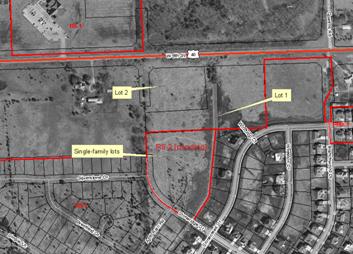
March 2005: The January rezoning requests were deferred by the applicant and new zoning requests were submitted for single-family for the southernmost portion of the property and conventional multi-family development for the area along W. 6th Street [RM-1 (Lot 1, eastern portion of subject property ) and RM-2 (Lot 2, western portion of subject property)].
July 2005: Approval of the RS-2 (Single-Family Residence) District zoning for the southern part of the property included discussion by both the Planning Commission and the City Commission concerning transition within the development, density, and stormwater run-off. The Planning Commission then initiated a rezoning of the property to a planned unit development (PRD-2 (Planned Residential District)) for the area abutting W. 6th Street.
August 2005: The Planning Commission discussion of the rezoning suggested the western portion of the subject property as appropriate for higher-density (15 dwelling units per acre) and the eastern portion appropriate for lower-density residential development. The City Commission’s consideration of the rezoning application further refined the density restrictions to cap the development at not more than 12 dwelling units per acre for the entire development. There was no proposed development plan that accompanied the proposed rezoning initiated by the Planning Commission.
November 2005: The currently approved Final Plat (Stoneridge East) combined the two lots shown in the Preliminary Plat as a single parcel following the rezoning to a Planned Unit Development for both lots.
March 2006: A Preliminary Development Plan was submitted for Planning Commission consideration at the March meeting where density, land use transition, and stormwater run-off were significant considerations. It was clarified that the proposed development included a detention pond and sufficient easement to control stormwater in the area has been provided. The applicant agreed to reconsider the development and revise the project to eliminate the multi-plex along Stonecreek Drive and to reduce the density to 12 dwelling units per acre by providing duplex units along the local street (May revision submitted). During that review KDOT also noted that improvements in the easement adjacent to W. 6th Street would not be allowed.
July 2006: The proposed Preliminary Development Plan was again revised to show the addition of 5-gallon shrubs along the southwest end of the development for screening and eliminated retaining walls from within the KDOT easement along the north side of the development. Previous review comments and recommendations stated that vehicular access to Stonecreek Drive should be access-controlled for emergency purposes only. The Plan showed the change in right-of-way for Winthrop Court which would have required the Final Plat to be reconsidered by the City Commission for vacation of existing right-of-way.
STAFF ANALYSIS
This project was submitted under the zoning regulations that predate the Land Development Code effective July 1, 2006. The proposed Preliminary Development Plan for multi-family development has been evaluated based upon the following suggested findings of fact and conclusions outlined in Section 20-1010.1 of the Zoning Ordinance for the City of Lawrence.
1) In what respects the plan is or is not in general conformity with the provisions of the Comprehensive Plan of the City.
The Comprehensive Plan, Horizon 2020 recommends infill development over annexation of new residential areas. The Plan also recommends a mixture of housing types, styles and economic levels for new development in a compatible density arrangement. The subject property is located on the southeast corner of W. 6th Street and Stoneridge Drive, an intersection of an arterial and collector street. These locations are generally suitable for medium density development. The proposed request is intended to represent a medium density development consistent with the definition of medium density found in Horizon 2020 between 7 to 15 dwelling units per acre (Page 5-3). Density was further restricted as part of the City Commission approval to not more than 12 dwelling units per acre. The proposed Preliminary Development Plan notes density at 11.86 dwelling units per acre. The proposed development is consistent with the density limitations established for the PRD and with conventional density analysis for a PRD.
Horizon 2020 expands the definition of medium-density residential development and states: “medium density residential areas are intended to promote a mix of housing types within planned development areas.” Development is intended to include a mix of single-family detached and attached homes, cluster homes, townhomes, and similar housing types. Development is recommended to avoid concentrations of same housing type. Horizon 2020 also states that medium-density residential development “should be designed to help avoid major and abrupt changes in density or use” (Page 5-4).
Horizon 2020 identifies the specific elements to be considered in development proposals and compatibility to include: use, building type, density, intensity of use, architectural style, scale, access, relationship to the neighborhood, and amount and treatment of screening and open space, with respect to location criteria. The land use zoning was approved for medium-density residential development as a Planned Residential Development and limited the density to a maximum of 12 dwelling units per acre and maximum building height of two stories (Residential Goal 1, Policy 1.1(a)).
The proposed development provides additional housing choices in the neighborhood but is oriented to the intersection rather than the developed single-family area to provide land use separation. Intensity of use is proposed to be addressed by the building type and orientation that abuts the southern portion of the development. This includes one-bedroom apartment units, removal of the clubhouse from the south side, and use of duplex units that front onto the local street segment that abuts a portion of the south property line.
Careful attention to transition areas is recommended by Horizon 2020. Previous staff reports addressed the distinction between “transition” and “buffering (screening)”. The initial action to rezone the property to a Planned Unit Development anticipated the use of multiple building types within the development with concentration of units at the northwest corner and smaller and fewer units provided to the south and east. Because of the limited size of the property and the encumbrances of the KDOT and drainage easement the developable area is confined.
Insufficient area is available to provide the types of interior yard areas for the lower intensity buildings without providing underground parking and much taller buildings. The existing streets on the north and west provide separation between the subject property and other uses in those directions. The approval of the subdivision plat created four single-family lots that abut the southwest portion of the site. The lack of internal transition therefore requires the provision of adequate buffering between the single-family lots (both developed and undeveloped) to address the recommended provision outlined in Horizon 2020. Buffering techniques include the building orientation, building separation and landscaping and screening treatments to effectively mitigate incompatible land use impacts.
The development plan has been revised to provide duplex units along Stonecreek Drive, as discussed at the March Planning Commission meeting, to provide a buffer between the existing single-family homes and the proposed apartment development and to reflect the existing housing type along the street frontage. The smaller buildings (1-bedroom units) are provided along the south side. A berm along the existing residence to the south is provided as well as increased landscaping materials and building separation.
Staff Finding – The proposed development is a medium density development consistent with the general land use recommendations and the approved zoning. The proposed Preliminary Development Plan addresses the issue of development compatibility between the single-family lots (developed and undeveloped) and the proposed development by providing buffering along the south property line with a concentration of landscaping, berming and building setback adjacent to the developed single-family lot.
2) In what respects the plan is or is not consistent with the Statement of Objectives of Planned Unit Development. [The statement of objectives of planned unit developments is found in Section 20-1002 of the Zoning Ordinance]
(1) To promote and permit flexibility that will encourage innovative and imaginative approaches in residential, commercial, and industrial development which will result in a more efficient, aesthetic, desirable and economic use of the land while maintaining density and intensity of use consistent with the adopted Comprehensive Plan for the City;
The approval of the zoning district limits the development to a maximum of two stories. The proposed Preliminary Development Plan was revised to provide a more compatible face to Stonecreek Drive, the local street, across from the existing single-family homes by including two duplex buildings that have front doors to the local residential street. Vehicular access to the units is provided interior to the development.
(2) To promote development within the City that can be conveniently, efficiently and economically served by existing municipal utilities and services or by their logical extension;
Extensions of water and sanitary sewer service were found to be available to the property as part of the subdivision review. The subject property is considered to be infill development; the surrounding areas are generally developed.
(3) To promote design flexibility including placement of buildings, and use of open space, pedestrian and vehicular circulation facilities to and through the site, and off-street parking areas in a manner that will best utilize potential on-site characteristics such as topography, geology, geography, size or proximity;
The revised development plan includes placement and use of duplex units in the southeast portion of the site to address land use transition concerns. The clubhouse building has been revised to eliminate the second story residential units and relocated to the front central portion of the development. The development includes pedestrian connections internal to the development. The development plan provides substantial open space around the site and within the development. The drainage and detention features are elements used to enhance separation of uses. Interior circulation and off-street parking are also accommodated within the development.
Additional landscape along the south side may be considered as part of the Final Development Plan to augment buffering of land uses between the proposed development and the abutting single-family lots. Primary access to the site is provided via the driveway access from Stoneridge Drive (a collector street). A secondary access is provided via the stub street of Winthrop Court to Stonecreek Drive (both are local streets). Staff has studied the ability to gate this access making it an emergency access only. This access is recommended to be gated on the private property side of the property to prevent direct access between the proposed development and the single-family development to the south. Access shall remain for emergency purposes.
(4) To provide for the preservation of historic or natural features where they are shown to be in the public's best interest including but not limited to such features as: drainageways, floodplains, existing topography or rock outcroppings, unique areas of vegetation, historic landmarks or structures.
The subject property is divided into an east and west half by a drainage channel, contained within a 40’ wide drainage easement, and includes both vehicle and pedestrian crossings connecting the two sides. No special approval of the crossings of the drainage easement is required from state or local regulatory agencies for the structures. The property also includes substantial grade changes across the site from both the north to the south and from the east to the west. Retaining walls are used along the north side of the development but were required to be excluded from the KDOT easement to accommodate any future roadway improvements.
The natural topography slopes increase to the north and east. This results in the base grade level being about 10’ higher than the abutting single-family lots to the south. Buildings are oriented around the perimeter of the site with off-street parking provided interior to the development. The limited height of the buildings will result in the W. 6th Street view being predominantly rooftops. Views from Stoneridge Drive and Stonecreek Drive (public streets) have been addressed as discussed with building type and landscaping. Additional recommendation for public views of the development address materials and architectural elements that shall be included as part of the final documents to assure consistency of treatment throughout the development and relationship to the development.
Staff Finding – This finding requires a review of the physical aspects of the development as they relate to the topography (slope and grade) as well as the drainage features of the site. The proposed Preliminary Development Plan clearly provides the inclusion of the drainageway into the development and makes it a part of the interior pedestrian circulation of the development.
3) The nature and extent of the common open space in the Planned Unit Development, the reliability of the proposals for maintenance and conservation of the common open space, and the adequacy or inadequacy of the amount and function of the common open space in terms of the densities and dwelling types proposed in the plan.
The proposed development provides the required amount of open space within the development (5.05 acres). Over 50% of the site is open space. Open space areas are found around the perimeter of the site, the drainageway in the center, two detention ponds at the south end and a common area on the west side. The area along the north side of the site represents a significant slope and is encumbered with a permanent easement by KDOT as part of the W. 6th Street gateway corridor. This area is not reasonable to provide pedestrian access to W. 6th Street except along the public street.
The large common area in the center part of the west side has been revised from previous versions to accommodate the clubhouse and pool area. Sidewalks and some surface parking lots provide access and exposure to this area. A similar common open space element is not provided on the east side, however pedestrian connections over the drainage easement allow for accessibility to the area.
Staff Finding –The proposed Preliminary Development Plan exceeds the requirement of open space and includes pedestrian access throughout the development. Much of the open area provided is encumbered with easement, drainage/detention purposes or steep slopes.
4) Whether the plan does or does not make adequate provisions for public services, provide adequate control over vehicular traffic, and further the amenities of light and air, recreation and visual enjoyment.
Primary Access to the development: Access to the site is provided from Stoneridge Drive (a collector street) and from Stonecreek Drive (a local street via a street stub connection of Winthrop Court). Access to Stonecreek was specifically discussed by the Planning Commission and the City Commission. The concluding action on the Final Plat was the approval of vacation of right-of-way for the stub street (Winthrop Court) from Stonecreek Drive. The Final Plat and rezoning predated the consideration of any design or development proposal for the subject property. Residential development is encouraged to have multiple access options as a general land use practice.
Winthrop Court Access/Vacation: The City Commission stated expressly that the entirety of the right-of-way would be vacated. The east half of the right-of-way vacation would be awarded to the applicant. The balance of the right-of-way would be dedicated or released to the abutting residential property owner. If fully vacated, the applicant’s burden would be to place the secondary access fully on their own property thus making the drive shift more to the east. Existing utilities would need to be relocated and the remaining half of the right-of-way would become the responsibility of the adjacent residential neighbor.
City staff; including public works, city stormwater engineer, and planning staff, reviewed Winthrop Court with respect to the vacation associated with the final plat given the proposed development plan. This review of the existing street improvements for Winthrop Court identified the existing stormwater inlets, secondary access needs, and the burden to the abutting property owner. City staff does not recommend the vacation of Winthrop Court that occurred through the Final Plat based on the proposed design. As a condition of approval the applicant will need to rededicate the vacated right-of-way that occurred through platting for the east half of Winthrop Court.
Assessment of the retention of Winthrop Court concluded that:
· Maintenance of the public right-of-way (assuming it is retained) is nominal to the City.
· Gated Access prohibits daily use and provides emergency secondary access within the development.
· Retaining the public right-of-way access for Winthrop Court would allow for future use or connection to the local street if necessary for some public purpose by removal of the gated entry.
· Retention of the public right-of-way does not result in abandonment of the existing stormwater system and the cost of construction of a new system in the same area.
Given the size of the development and number of dwelling units secondary access is appropriate. A significant neighborhood concern has been stated that direct access to the neighborhood via Stonecreek Drive is considered to be unacceptable. The proposed Preliminary Development Plan shows the access of the development tying into the existing stub street (Winthrop Court).
Secondary access to Stonecreek Drive can be addressed with a gated access for use only by emergency services as needed. This is an acceptable solution to the City Fire/Medical Department. The Final Development Plan would require the provision of notes to show the gate and the type of lock method per City Fire/Medical Department approval.
Staff Finding – A Planned Unit Development is required to provide access to a collector street. The proposed development complies with this criterion. Off-street parking and interior access accommodate the use per city standards. Utilities can be extended to serve the site. Given the concerns raised about the proposed development and the orientation to the existing development a compromise was developed that would retain the access for emergency purposes only and would necessitate the provision of a gate to restrict access and cross circulation between the proposed multi-family development and the adjacent single-family area to the southeast. Staff recommends the Preliminary Development Plan be revised to show and note the provision of a gated entry of the development to Stonecreek Drive.
5) Whether the plan will or will not have a substantial adverse effect on adjacent property and the development or conservation of the neighborhood area.
A portion of the south side of the subject property abuts single-family lots that are also under the same ownership as the subject property. They are not developed at this time. The eastern half of the subject property abuts developed single-family homes, public street right-of-way and undeveloped property to the east owned by a church.
The subject property abuts W. 6th Street and includes a required 50’ setback. This area will be required to be landscaped with street trees. This area also overlaps with permanent easement owned by KDOT limiting the allowable improvements in the area. The subject property generally sits at a lower elevation that the adjacent roadway of W. 6th Street. The property is also higher than the residential lots to the south. Building height is comparable within approximately 10’ of existing two story homes in the neighborhood.
Previous discussions regarding this proposed development concluded that the property could not be adequately addressed with transitional techniques within the development. Therefore buffering would be required to provide separation of land uses. The primary buffering technique used is the back-to-back building arrangements along the south side excluding the duplex units that front to Stonecreek Drive and the provision of dense landscape materials.
Staff Finding –The Preliminary Development Plan shows the general location, species and number/size of materials proposed and has not been significantly altered in more recent versions of the plan. Staff recommends that plantings along the lot abutting Stonecreek Drive should be installed at larger sizes to augment the growing time it will take to provide screening. Key to the success of the development and screening will be regular maintenance of the buffer area.
6) In what respects the plan is or is not in conformance with the development standards and criteria of this article. [The general standards are found in Section 20-1006 and Preliminary Development Plan requirements are listed in Section 20-1010]
The proposed development plan has been revised to comply with density restrictions and calculations as are required for the proposed district. General notes have been provided in the most recent revision to address phasing and maintenance responsibility of the open space and other common elements.
Staff Finding - The proposed Preliminary Development Plan complies with the required development standards.
7) In what respects the plan is or is not in compliance with the requirements for application for tentative approval of the Planned Unit Development. [This finding refers to Section 20-1005 of the Zoning Ordinance-pre 7/1/06.]
(a) A plan that is consistent with (1) the "Statement of Objectives for Planned Unit Development," (2) the adopted Comprehensive Plan of the City, (3) the development standards set out herein, and (4) any specific rules and regulations for Planned Unit Developments adopted from time to time by the planning commission and city commission and placed on public record in the office of the city clerk shall be deemed to be qualified for tentative approval. No such rules and regulations shall be revised or added to so as to be applicable to a specific proposal for a Planned Unit Development after an application for tentative approval has been filed by the landowner or his or her agents.
(b) A plan shall be consistent with the following standards for the use, type, bulk, design and location of buildings, the density or intensity of use, the common open space, the public facilities and the development by geographic division of the tract.
Staff Finding –As noted above the proposed development plan has been revised to comply with the density limitations and to provide buffering to address land use changes between abutting uses.
8) The sufficiency of the terms and conditions proposed to protect the interest of the public and the residents of the Planned Unit Development in the case of a plan that proposes development over a period of years.
The proposed development is shown as a single phase. This element will be confirmed with the Final Development Plan. Notes will be needed on the Final Development Plan to clarify the level of site improvements to be completed before occupancy. Access to W. 6th Street is recommended as a condition of approval prior to occupancy of the development. Vehicular circulation during the construction of the project will require additional discussion to mitigate access to the adjacent local street. It is not anticipated that total removal of construction traffic can be maintained during actual development.
Staff Finding –The Proposed Preliminary Development Plan provides adequate notation to address the phasing of the development.
9) Stormwater detention calculations and storage of excess stormwater drainage as per City Policy.
The proposed development includes a 40’ by 525’ drainage easement and two detention ponds. City staff has reviewed this area and the submittal documents to assess the requirements for the area. City Staff has also met with area residents to view the area prior to the public hearing in March and has reviewed all subsequent versions of the plan. The proposed easements and detention ponds are provided on the plan as required by city code to serve this area. Staff has not identified any deficiencies in the submission documents or the proposed stormwater management plan for the proposed development.
Staff Finding – A stormwater study was provided with the application and was reviewed and accepted by the Public Works Staff.
Staff Review
The subject property is located on the south side of W. 6th Street and on the east side of Stoneridge Drive in the West Lawrence Neighborhood. The property is divided into an east and west side by a significant drainage easement. The proposed development attempts to unite these two sides with a vehicular/pedestrian bridge crossing on the north end and a separate pedestrian bridge further to the south. The subject property is also abutted by proposed single-family lots as part of the Final Plat that also includes the subject property. These single-family lots are not developed and are under the same ownership as the proposed development. Key development concerns identified in this project are:
· Density – Maximum density is set at 12 dwelling units per acre.
· Transition/Buffering- Provision of land use transition within the site is required to address both the north to south orientation as well as east to west orientation. Buffer techniques are used when incompatible or unlike land uses abut without the provision of a transition zone. Techniques include berms, fencing, landscape screening and building separation. Land use transition is the layering of land uses from more intensive to less intensive in increasingly restricting manner. Conventional applications include progressively restrictive zoning such as commercial, multi-family, duplex and single-family development from an arterial street down to a local street level. Previous considerations by the Planning Commission of the proposed development abandon the transition concept because of the limited size of the property. The plan could be revised to include smaller buildings (duplex and triplex units) adjacent to the single-family homes along the south side of the property. It was concluded from the previous discussions that buffering rather than transition would be provided to reduce impacts between the multi-family and single-family uses. This is accommodated with back-to-back building relationships and landscape screening.
· Access – Secondary access is proposed from Stonecreek Drive, a local street on the southeast portion of the development. The proposed development ties directly into a public street. Secondary access was noted in the staff discussion with both the Planning Commission and the City Commission at the time of zoning. It was acknowledged that dependant upon the type and intensity of development, in terms of the total number of dwelling units, secondary access would be recommended for minimum emergency/safety access. Fire/Medical staff has indicated that secondary access from Stonecreek Drive is required unless all structures east of the drainageway are constructed with fire sprinkler systems. Likewise general land use principles support the concept of secondary access. The controlled access option is provided as a compromise to cut-through traffic concerns to a local street raised by area neighbors.
Vacation of the right-of-way would unnecessarily burden the adjacent property owner and the location of existing utilities would need to be relocated and reconstructed. Additionally the access can be controlled with a restrictive gate.
· Maintenance –The provision of a landscape buffer between the proposed development and the single-family lots to the south is a critical element. The ongoing maintenance of the buffer area will be required to assure health and continued growth of plants in the area. There are no proposed covenants or restrictions associated with the proposed development. Common open space will be regulated as part of the Final Development Plan. Loss of materials because of disease or lack of maintenance will require new landscape materials to be replanted.
Rights-of-way
Additional right-of-way is not required as part of the Preliminary Development Plan. Easements and right-of-way are included in the dedication of the Final Plat along with the vacation of a portion on of Winthrop Court as approved by both the Planning and City Commissions. Adequate right-of-way is provided for this intersection for the proposed development.
City Staff and KDOT personnel have indicated concern that the intersection of W. 6th Street and Stoneridge Drive will need geometric improvements in the future based on traffic growth from W. 6th Street and development to the north. Placement of traffic signals and turn lanes may be needed resulting in future intersection improvements for the W. 6th Street/Stoneridge Drive intersection. Staff does not anticipate the need for additional right-of-way.
The immediate intersection improvements must be completed prior to occupancy of any portion of the development. Development of this property should be made subject to agreement to participate in future intersection and signal improvements.
Planned Residential Developments are required to have direct access to a collector road. The proposed development is oriented to Stoneridge Drive to accommodate this requirement.
Use Restrictions
The property is zoned for Planned Residential Development (pending approval of Preliminary Development Plan) subject to two restrictions. The building height was limited to two stories, but no additional height description was added. The density of the development was restricted to a maximum of 12 dwelling units per acre by the City Commission.
Building Orientation
The proposed buildings provide a back-to-back relationship to the surrounding area. Buildings are generally located adjacent to the minimum setback requirement for a PRD of 35’ on the south side of the development. Section 21-1006(j) states “If topographical or other barriers within 35 feet of the boundaries of the Planned Unit Development do not provide reasonable privacy for existing uses adjacent to the development, the planning commission shall impose either of the following requirements or both;
1. Structures located along the boundary must be setback from the boundary a distance which is approved by the commission; and
2. Structures located along the boundary must be well screened in a manner which is approved by the Commission.
This language provides authority for the Planning Commission to increase the building setbacks and to require more and/or larger vegetation in buffer areas.
In a meeting with the applicant’s representatives and residents, staff identified specific areas where building material treatments shall be required to provide continuity of building type between the subject property and the existing built homes in the area. The Final Development Plan shall include specific building elevations that note building materials to be used for roof, siding, and facing elements visible from the public streets and viewable from abutting properties.
Closing
The revised Preliminary Development Plan was submitted to specifically removed improvements from the KDOT easement, relocate the clubhouse and pool complex and provide greater separation between the existing developed lot on the south side and the proposed apartment building north of Winthrop Court on the east half of the development. Previous revisions addressed the interface of the project with lots along Stonecreek Drive and to reflect the approved maximum density of 12 dwelling units per acre for the development.