|
PLANNING COMMISSION REPORT SUMMARY Regular Agenda - Public Hearing Item |
|
ITEM NO. 10: RS7 to RM12; 10.74 ACRES; ALL OF LOTS 1-4 OF BLOCK 1 (SLD)
Z-07-21-06: A request to rezone a tract of land approximately 10.74 acres, from RS7 (Single Dwelling Residential) to RM12 (Multi-Dwelling Residential). The property is located at 3000 Sherwood Drive; all of Lots 1-4, Block 1, Deerfield Woods No. 3 Submitted by Donald Funk for Cheer Pole, Ltd., property owner of record. |
|
STAFF RECOMMENDATION: Staff recommends denial of the 10.74 acres from RS7 to RM12 District and forwarding it to the City Commission with a recommendation for denial based on the findings of fact found in the body of the staff report. |
|
Reason for Request: |
To construct townhomes. |
|
KEY POINT
|
|
GOLDEN FACTORS TO CONSIDER SURROUNDING ZONING AND LAND USE
CHARACTER OF THE AREA
CONFORMANCE WITH THE COMPREHENSIVE PLAN
|
|
ASSOCIATED CASES/OTHER ACTION REQUIRED
|
|
PUBLIC COMMENT RECEIVED PRIOR TO PRINTING
|
GENERAL INFORMATION |
|
|
Current Zoning and Land Use:
|
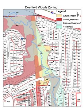
RS7 [Single-Dwelling Residential] District and FP [Floodplain Management Regulations Overlay District]; undeveloped lots. |
|
Surrounding Zoning and Land Use: |
RS-7 [Single-Dwelling Residential] District to the east and west; [existing single-family residential neighborhood.
A [Agricultural] District to the north; unincorporated residential property; recently approved CUP for communication tower.
PRD [Deerfield Woods] to the south; developed duplex residential homes.
RM12 [Multi-Dwelling Residential] District to the southwest; Deerfield Woods Townhomes [SP-06-31-95]. |
I. ZONING AND LAND USES OF SURROUNDING PROPERTIES
Staff Finding – The subject property is surrounded by residential zoning and land use. The northernmost boundary of the property abuts a property that is outside of the city limits but is a county residential property.
II. CHARACTER OF THE AREA
The subject property is part of the Deerfield Woods development. This area is generally located north of Peterson Road and east of Kasold Drive. This area has been subdivided and developed in phases since the late 1980’s and early 1990’s. The majority of the area is characterized by detached homes on individual parcels or lots. Small development areas along Peterson Road include duplex and townhouse developments.
Another characteristic of the area is the location of floodplain across the area known as the Deerfield Tributary that runs from the southeast to the northwest. Another branch (West Fork Deerfield Tributary) is located parallel to Sherwood Drive. Much, but not all, of the floodplain is covered by drainage easements as part of the subdivision plat process. The presence of the floodplain has shaped the neighborhood by limiting street connections (east and west) and lot configuration for those areas that abut the drainage easement areas.
Staff Finding – The area is characterized by single-family detached homes on individual lots with the exception of some limited areas along Peterson Road.
III. SUITABILITY OF SUBJECT PROPERTY FOR THE USES TO WHICH IT HAS BEEN RESTRICTED
|
|
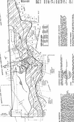
The subject property is currently zoned for single-dwelling detached development. The subject property includes four platted lots. The largest lot includes 9.4 acres. The current lot configuration is a result of a 1995 replat of the area. This replat occurred following and as a condition of a rezoning request for PRD zoning in 1994 that generally separated the southern area abutting Peterson Road which became Deerfield Woods PRD and retained the balance of the area as single-family residential.
As noted the property is encumbered by floodplain along the east side. There is an existing exclusive utility easement located along the west boundary of the zoning district. This easement is a 100’ Westar easement for an overhead power transmission line. The location of this utility and corresponding easement has resulted in larger lots or setbacks as the area has developed.
|
|
The purpose of the RM district is to accommodate multi-dwelling housing. The multi-dwelling districts are intended to “create, maintain and promote higher density housing opportunities in areas with good transportation access” (Section 20-204, Land Development Code). Approval of the request would allow for additional density and housing type within a specific area of the neighborhood that is surrounded by floodplain and platted and developed residential lots.
The primary purpose of the RS district “is to accommodate predominately single detached dwelling units on individual lots” (Section 20-202, Land Development Code). Single-family detached homes on individual lots is the predominate land use pattern of the neighborhood excluding small developments immediately adjacent to Peterson Road.
Staff Finding – The current zoning for single-family residential development is suitable and consistent with the development pattern of the surrounding area.
IV. LENGTH OF TIME SUBJECT PROPERTY HAS REMAINED VACANT AS ZONED
Staff Finding - The property has been zoned RS7 since the adoption of the Land Development Code in July 2006. Previously the property had been zoned RS-2 (Single-Family Residence) District since 1988. The subject property was part of the 145 acres included in the Preliminary Plat for Deerfield Woods Subdivision. This information is taken from the staff report 9/28/94 for Z-8-22-04.
V. EXTENT TO WHICH REMOVAL OF RESTRICTIONS WILL DETRIMENTALLY AFFECT NEARBY PROPERTY
The subject property will be accessed directly from Sherwood Drive. There is no ability to extend a cul-de-sac from either the east or west into the developable portion of the subject property without crossing the creek or encroaching on existing or developed lots.
The subject property was part of a replat in 1995 that separated the single-family lots from the PRD area to the south (Deerfield Woods PRD). A rezoning request was made in June of 1994 for RM-1 (Multiple-Family Residence) District for the subject property including a 12.89 acre tract abutting Peterson Road (Z-06-18-94). The request was withdrawn and then replaced with a revised request (Z-8-22-94) that amended the area to the south of the subject property of this request to PRD and retained the balance of the area (all of the area included in this request) as single-family. A specific discussion of that rezoning discussion, establishing the PRD in 1994, was that the PRD area would be restricted from Sherwood Drive and take direct access only to Peterson Road thus preserving the single-family pattern of that street face. The zoning boundary was deliberately established to separate the single-family from the multi-family area. It is likely that property owners along Sherwood Drive have relied on the intent that the remaining undeveloped lots along Sherwood Drive would remain as single-family lots.
If the area had been rezoned for multi-family development in 1994, the PRD would have likely included this area as well and extended John Doy Court further to the North thus providing access directly to Peterson Road as was intended in the original approvals.
As a condition of approval, the property had to be replatted. This replat was completed in February 1995 as “A Replat of Deerfield Woods Subdivision No. 3”.
The total development area is limited by the proximity of the floodplain and the exclusive utility easements. The cul-de-sac that terminates Sherwood Drive has not yet been constructed. The ability to develop within this area is limited and has not been assessed. There is no active development proposal submitted at this time for review to determine the feasibility. Impacts of development on adjacent properties will be the additional traffic (minimal), structures, parking and activity at the end of the street. The area that is not encumbered by floodplain and/or exclusive utility easement is approximately 1.5 acres. Staff estimates that about 12-15 total units could be developed within this area based on gross numbers.
Staff Finding – Detrimental impact cannot be fully assessed for this change in zoning without a site plan submission for review. Four additional single-family homes can be constructed on the subject property based on the existing zoning. If approved, the density would be comparable to what is developed along Peterson Road.
VI. RELATIVE GAIN TO THE PUBLIC HEALTH, SAFETY AND WELFARE BY THE DESTRUCTION OF THE VALUE OF THE PETITIONER’S PROPERTY AS COMPARED TO THE HARDSHIP IMPOSED UPON THE INDIVIDUAL LANDOWNERS
Evaluation of this criterion includes weighing the benefits to the public versus the benefit of the owners of the subject property. Benefits are measured based on anticipated impacts of the rezoning request on the public health, safety, and welfare.
There is no public benefit to the proposed rezoning. Approval of the request will allow for the developer to construct additional residential units in a smaller area including multiple units on individual lots.
The overall neighborhood has access to and includes areas of varied housing types along the perimeter of the neighborhood. These areas have been specifically designed to provide a specific type of development. The subject property is essentially that area that is bounded by physical constraints including a floodplain, existing development and large exclusive utility easements.
Staff Finding – If denied the property can continue to be developed for residential purposes limited to single-family detached housing. There is no identifiable public benefit that results from the proposed change.
VII. CONFORMANCE WITH THE COMPREHENSIVE PLAN
The subject property is located in an existing neighborhood. The area was specifically platted and zoned in a configuration to separate the multi-family elements from the established single-family lots within the developable portion of the subject property near Sherwood Drive.
The Future Land Use Map shows this area as suitable for and designated as very low and low- density residential uses (Map 3-2). The subject area is platted and zoned for this use, but as yet undeveloped. General policies of the plan outlined in Chapter 3 support the concept of infill development that is “consistent and compatible with established land use pattern in surrounding areas.” The plan also addresses topics of preservation of floodplains and riparian ways, provision of transitions in land use and intensity levels and identification and preservation of historic and archeological sites within the community. (Page 3-1)
Low density development is characterized as six or fewer dwelling units per acre (Page 5-3) where as the proposed density would allow up to 12 dwelling units per acre. The proposed zoning district corresponds to a medium-density land use as noted in the Land Development Code Section 20-201 (b).
Specific policies related to this development request are listed below:
RESIDENTIAL LAND USE GOAS AND POLICIES
Low-Density Residential Land Use
GOAL 3: Neighborhood Conservation
The character and appearance of existing low-density residential neighborhoods should be protected and improvements made where necessary to maintain the values of properties and enhance the quality of life.
Policy 3.3: Encourage Compatible Infill Development
a. Encourage redevelopment and infill as a means of providing a variety of compatible housing types within neighborhoods.
c. Infill development should conform to lot size, housing type, scale and general architectural style of the area in which it is proposed.
d. Discourage the conversion of existing single-family residences to multiple-family use unless the existing zoning of the property permits multiple-family development.
f. Maintain the physical form and pattern of existing, established neighborhoods to the extent possible by incorporating the following principles:
GOAL 4: Criteria for Location of Low-Density Residential Development
Policy 4.1: Consider Land Use Relationships
Development proposals should be reviewed for compatibility with existing land uses, including any neighborhood plan. This review should include use, building type, density, intensity of use, scale, access and its relationship to the existing or planned circulation patterns of the surrounding neighborhood, and the amount and treatment of screening and open space.
Policy 4.2: Protect Areas Planned for Low-Density Development
Avoid concentrations of medium- or higher-density residential development within the interior of a neighborhood.
GOAL 5: Create a Functional and Aesthetic Living Environment
Create and maintain neighborhoods that are aesthetically pleasing and functionally efficient and practical.
Policy 5.1: Preserve and Protect the Environment
Natural environmental features within residential areas should be preserved and protected. Natural vegetation and large mature trees in residential areas add greatly to the appearance of the community as a whole and should be maintained. Changes to the natural topography should be minimal.
Policy 5.2: Encourage Proper Lot Orientation
a. Encourage subdivision design in which residential lots are oriented towards, and take access from the neighborhood of which they are a part.
GOAL 6: Compatible Transition from Low-Density Residential Development to More Intensive Land Uses
Ensure transition from low-density residential neighborhoods is compatible with more intensive residential and non-residential land uses.
Policy 6.1: Use Appropriate Transitional Methods
1. Building Relationships
2. Land Features
Policy 6.2: Higher-Density Residential Development as Transitional Use
Encourage the integration of higher-density residential development through compatible design with non-residential developments and surrounding low-density residential neighborhoods.
Medium- and Higher-Density Residential Land Use
Policy 1.1: Consider Land Use Relationships
a. Development proposals shall be reviewed for compatibility with existing land uses. The review should include use, building type, density, intensity of use, architectural style, scale, access and its relationship to the neighborhood, and the amount and treatment of screening and open space.
b. Careful attention shall be given to the transition areas between different housing types and different densities and intensities of use so as to ensure compatibility of uses.
c. Encourage integrated compatible community facilities such as schools and churches within neighborhoods.
Policy 1.7: Adhere to Designated Land Uses
GOAL 2: Create a Functional and Aesthetic Living Environment
Create and maintain medium- and higher-density residential developments that are aesthetically pleasing and functionally efficient and practical.
Policy 2.1: Preserve and Protect the Environment
Preserve natural features such as natural drainageways, ridgelines and stands of mature trees through sensitive site layout and design.
Policy 2.6: Consider Residential Density and Intensity of Use
a. The number of dwelling units per acre in any residential category should be viewed as representing a potential density range rather than a guaranteed maximum density. Potential development should be approved based upon consideration of natural features, public facilities, streets and traffic patterns, neighborhood character, and surrounding zoning and land use patterns.
b. Develop standards for density and intensity of uses.
GOAL 3: Compatible Transition from Medium- and Higher-Density Residential Development to Both More Intensive and Less Intensive Land Uses
Ensure transition from medium- and higher-density residential neighborhoods is compatible with non-residential land uses or low-density residential land uses.
Policy 3.1: Use Appropriate Transitional Methods
Policy 3.2: Medium-Density Residential Development as Transitional Use
Policy 3.4: Encourage Compatible Infill Development
Staff Finding – The proposed rezoning application does not meet the recommended goals and policies of Horizon 2020 related to neighborhood conservation or building relationships that are likely to result if approved. Medium density residential development as a transition use in this location is not needed.
STAFF REVIEW
The subject property includes unique limitations to development resulting from the location of existing floodplain and the utility easements across the property. Approval of the request would allow for an attached housing type on the property but would result in an odd building orientation because of the narrow confines of the building area.
The area located on the north side of Sherwood Drive is exceptionally large. It is not unreasonable to think that if developed it could be replatted to separate the drainage portions of the lot into a separate tract. The proposed rezoning is not supported by staff as it is inconsistent with the comprehensive plan and the established land use patterns of the area. The existing single-dwelling zoning is suitable for the remaining developable portions of the subject property.