![]() CHAPTER FIVE - RESIDENTIAL LAND USE
CHAPTER FIVE - RESIDENTIAL LAND USE
![]()
Lawrence and Douglas County have traditionally been strong and desirable residential communities. The Comprehensive Plan strives to strengthen and reinforce existing residential areas and promote quality new residential development in select areas. It includes strategies and general development policies for guiding improvement and development within residential areas, and specific recommendations for the type and location of new residential development.
STRATEGIES: RESIDENTIAL DEVELOPMENT
The principal strategies for approaching residential land use areas are:
• Requests
for annexation shall be consistent with approved watershed/sub-basin,
sector, neighborhood, nodal, corridor, specific issue/district neighborhood plans, area development plans and
sector plans.
• Infill residential development should be considered prior to annexation of new residential areas.
• A mixture of housing types, styles and economic levels should be encouraged for new residential and infill developments.
• Compatible densities and housing types should be encouraged in residential neighborhoods by providing appropriate transition zones between low density residential land uses and more intensive residential development, and between higher density residential uses and non-residential land uses.
• The character and appearance of existing residential neighborhoods should be protected and enhanced. Infill development, rehabilitation or reconstruction should reflect architectural qualities and styles of existing neighborhoods.
• Neighborhood plans, area development plans and sector plans should be developed or amended to reflect the Comprehensive Plan's goals and policies for residential development.
• Design, site improvements and infrastructure shall be consistent with adopted neighborhood plans, with the development of a neighborhood concept and with area plans and sector plans.
• New residential development in Douglas County should protect and enhance the rural character and quality of unincorporated portions of the County.
• Clustering of development shall be encouraged when considering residential development in the unincorporated portions of the county to preserve the rural character, protect environmentally sensitive areas and to more efficiently provide services.
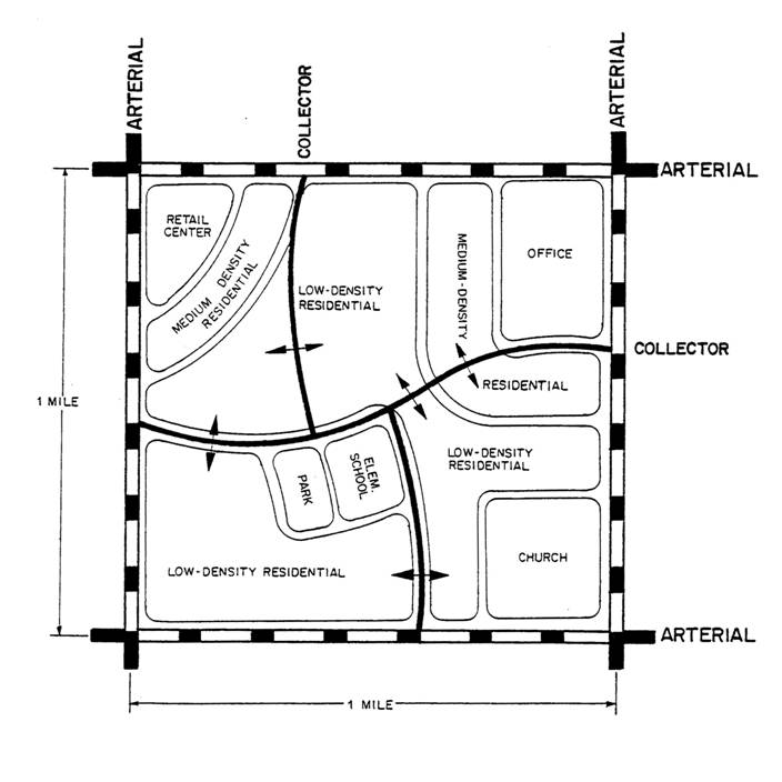
Figure 5-1 - Planning Unit Concept
CITY OF LAWRENCE
The Comprehensive Plan promotes a balanced mix of housing within the community which would allow for a wide range of housing types and residential densities. The Plan includes four residential area designations, as described below.
Very Low-Density Residential Development
Very low-density residential development, with densities of one or fewer dwelling units per acre, may occur in various parts of the UGA. One acre minimum development sites should be utilized in areas to be annexed into the city which may have natural features that pose development challenges but do not preclude the delivery of urban services. This category could have applications in several fringe areas of the city. In this category, development standards may be modified to reflect the very low-density character of the area.
Low-Density Residential Development
Low-density residential development, reflecting a density of six or fewer dwelling units per acre, would continue to be the predominant land use in the city. While this classification includes densities that would encompass duplex and some townhouse development, emphasis is placed on single-family detached development.
While existing single-family neighborhoods are essentially built-up, several vacant parcels are scattered throughout the existing community where new low-density residential development should occur in the future. In general, new development should be of a scale and character, including building type, the same as and compatible with existing or planned homes in the immediate area. New low-density residential areas are located generally in the southern and western portions of the community and in the UGA.
New large-scale, low-density, single-family residential development is recommended to the west of the city. These new neighborhood areas should be designed and located to preserve and enhance the natural and environmental features existing within the area. In general, the area west of the planned SLT should not develop until comparable areas east of the trafficway are largely developed. For example, areas planned for residential development east of the trafficway (generally between Wakarusa Drive on the east and the SLT on the west) should be substantially complete prior to additional residential areas west of the trafficway being developed. In addition, the South Lawrence Trafficway should be completed prior to development to the west to ensure proper functioning of the planned street/road network. The staging of development in the area is discussed in greater detail in Growth Management.
Medium-Density Residential Development
Medium-density residential development, reflecting an overall density of 7 to 15 dwelling units per acre, is recommended as clustered development at selected locations along major roadways, near high-intensity activity areas, and when adjacent to important natural amenities. This type of land use may be a likely choice for cluster development where density can be transferred from the natural area to the remainder of the property to creatively retain natural features which will enhance the overall development.
Medium-density residential areas are intended to promote a mix of housing types within planned development areas. Medium-density areas should include a mix of single-family detached and attached homes, cluster homes, townhouses and similar housing types, designed and arranged to create compatible and attractive new residential environments. Extensive concentrations of the same housing type or development pattern should be avoided.
Most of the sites recommended for new medium-density residential development occupy transitional locations between single-family neighborhoods and office/commercial areas. Some sites are recommended near large open space or natural areas. In addition to providing attractive new housing options within the city, these areas should be designed to help avoid major and abrupt changes in density or use. Existing and planned medium-density residential development is widely scattered throughout the city.
High-Density Residential Development
High-density residential development, reflecting an overall density of 16 to 21 dwelling units per acre, is recommended at selected locations near high-intensity activity areas or near existing high density residential developments.
A variety of locations for high-density residential development are recommended. These include sites primarily along the SLT and Eastern Parkway.
Large concentrations of high-density housing are not compatible with the overall character and development pattern of the city and should not be permitted. As with medium-density housing, a range of densities and housing types should be encouraged. The design and development of all new high-density residential development should be carefully controlled to ensure compatibility with surrounding uses, adequate screening and buffering, an attractive appearance from nearby roadways, and a high-quality living environment.
LAWRENCE URBAN GROWTH AREA
A key element of the Plan is the designation of urban growth or "service" areas and the adoption of policies pertaining to future growth and development of Lawrence. The urban service approach to guiding growth and development relies on establishing future areas where municipal facilities are planned and can be provided. These requirements are a primary land use planning consideration and should be used in conjunction with the other land use planning considerations discussed in other sections of this Plan. In the Plan, land within the city is part of the "existing service area" and is deemed to meet the test of adequate facilities and services.
The Plan identifies four service areas in the
overall UGA which have specific recommendations for growth and development. All
land divisions within the Lawrence UGA will have an administrative
review procedure or be platted. The timing of
development, and any conditions prerequisite to development in each of the
service areas, are described in Growth Management.
UNINCORPORATED DOUGLAS COUNTY
Douglas County plans to continue to receive new non-farm rural residential development
in the future. New growth is anticipated to include a range of residential
development
options,
including clustered housing and traditional subdivision areas. including limited
divisions for rural residential purposes. and larger acreages for platted
subdivisions. All development shall be designed for safe access to roads and
with building areas that are defined to avoid encroachment in to
environmentally or geographically sensitive lands, FEMA designated floodplains,
or sites of historic landmarks or other historic features. Locations appropriate
for each of these developments are described below.
Rural
Service Area
The Rural Service Area covers the vast
majority of unincorporated Douglas County. It includes all areas outside except the UGA’s of Douglas County cities and non-residential
development locations. The rural district establishes a minimum residential parcel size in the Rural Service Area is based on the
minimum lot frontage required for the road classification the parcel abuts or takes
access from but in no case shall it be less than three (3) acres. of five acres for
unplatted non-farm residential development with a minimum frontage on a public
road of 250 feet. The rural district Rural Service Area encompasses Douglas County farms, ranches, agricultural uses, and natural and environmentally sensitive
areas. The basic zoning district standards in the Rural Service Area are shall be designed to permit non-farm
residential development in a manner that is consistent with conservation of the rural character and pattern of land
use in Douglas County.
Residential subdivisions in unincorporated Douglas County are discouraged in the
Rural Area permitted subject to subdivision improvement standards. Minimum
lot sizes in suburban/rural
subdivisions should generally be three acres or larger. The availability
of water supply and the type of sewage system proposed (such as water meter or
well with on-site septic system) should be considered in the determination of
minimum lot sizes in individual circumstances. An individual on-site
sewage management system may be constructed upon any parcel, tract, or lot
which is three acres or greater when a public water supply is provided, and the on–site wastewater
management system site is entirely outside the regulatory floodplain. or which is five acres
or greater when a non-public water supply is provided.
The majority of Rural subdivisions should be
directed to the designated UGA and Planning Areas of incorporated cities and should not be
scattered throughout the rural district Rural Service Area. Circumstances Criteria which could support the
location of a subdivision within these the UGA areas would be the location of a contiguous
platted subdivision presence & access to a paved road, availability of rural water meters,
and the significant existence of other rural residential subdivisions or
groupings of dwellings. The developable portion of the residential parcels or
lots shall not include: steep slopes (15% or greater), FEMA designated
regulatory floodways, other environmentally sensitive features, or sites of
historic landmarks or historic features. When land appropriate for rural residential uses residential development is proposed for residential
development adjacent to the UGAs of incorporated cities, the development shall
be should
be encouraged designed, and parcel divisions
created, in anticipation of annexation by the city so that the parcels created
can be further subdivided into lots that fit the urban development pattern of
the annexing city, thereby minimizing disruption of the urban development
pattern and reduction in the total acreage
removed from agricultural uses.
Agricultural uses should continue to be the predominant land use within the areas of the county beyond the designated urban growth/service areas (rural area). Uses permitted in the rural area should continue to be limited to those which are compatible with agricultural production and uses. Uses which allow farmers to sell directly to the consumer, such as seasonal farm stands and pick-your-own farm operations, provide flexibility and incentives to retain agricultural land in production. Residential development should be limited in these areas so that new development does not unnecessarily remove productive land from agricultural use.
Urban Growth Areas And Planning Areas
Map 3-3, Douglas County Urban Growth Areas illustrates the UGA boundaries for Lawrence and each of the other incorporated cities in Douglas County, with the recognition that these boundaries will change over the planning period. The Planning Commission shall utilize the Comprehensive Plan for the unincorporated areas with overlapping UGA’s in the communities of Baldwin City, Eudora and Lecompton, unless lands are lawfully annexed. The change in individual growth boundaries of the communities of Baldwin City, Eudora and Lecompton shall not require amendment to this Plan. However, future planning efforts of all these incorporated communities are encouraged to coordinate with the Douglas County Commission.
The Plan suggests the use of an Estate Conservation-Cluster Rural
Residential
development
category rural with a minimum residential development parcel
size of 3 acres densities of 1 or fewer dwelling units per
acre in/near sensitive areas within
the Urban Growth Areas of the incorporated cities in Douglas County.boundary. This type of very
low-density residential development could accommodate lots which might be 3-5
acres if developed in an UGA without urban services, or one acre minimum in
areas annexed into the city which might have natural features that pose
development challenges but do not preclude the delivery of urban services.
Development in this manner category is intended to create occur in a cluster type of development pattern that is
respectful of the conservation of natural and historic resources and other
sensitive lands. This development pattern should also anticipate the future
extension of
urban services, and the potential for resubdivision for more urban densities of
development after annexation by a city . and Modified development standards are recommended to permit integration with minimal
disruption to the natural features and the character of the area. Zoning and Subdivision
Regulations should be amended to create the flexibility needed for modifying
standards where it would reflect the low-density character of the area and not
be harmful to the public interest.
Development and growth within Lawrence UGA shall be governed by this Plan.
SPECIFIC RECOMMENDATIONS FOR SELECT AREAS
· North Lawrence Infill Residential Development
The North Lawrence neighborhood, located northeast of the Kansas River, is one of the least intensely developed residential areas. It includes a number of larger, vacant parcels potentially subject to infill development in the future.
While portions of this area maintain a more intense, or at least a mixed-density character, the area lying east of 8th Street/road includes larger, vacant sites. This area should be maintained for larger lot single-family detached development.
· Riverridge Residential Area
Unlike most other neighborhood areas of the city, the Riverridge neighborhood includes substantial portions which are currently unincorporated and are not served with municipal sewer and water facilities. In order to permit continued and orderly development of the greater neighborhood area, it is desirable that the Riverridge area be serviced with utilities and improved street/roads to enable the extension of the systems to adjoining areas.
· Alternative Residential Land Use Areas
There are two locations identified within the Lawrence UGA which may receive urban development in the future, but which are subject to special approval due to conditions which currently exist or which will influence the area in the future.
1. Far South Lawrence Residential Reserve
Because this area is part of the Lawrence school system and is reasonably close to existing employment centers, it has experienced renewed residential development in recent years. If wastewater treatment is provided to this area, the area will experience significant pressure for additional development. While development is not undesirable, there are a number of conditions which should be demonstrated prior to endorsing the area for urban development.
The city has planned for an adequate amount of available land suitable for future development in other portions of the urban area, excluding the area south of the Wakarusa River. Therefore, development of the far south area is not directly tied to meeting the land use objectives of the Comprehensive Plan. Opening the area to urban development creates a number of transportation access and community facilities considerations. It is intended that the area will be considered part of the Douglas County Rural Area unless a number of conditions are met for development as described in Growth Management.
Should the area be
opened to development in the future, the dominant land uses planned for this
area include low-density or very low-density residential uses and extensive public and private open spaces due to the presence of
the Wakarusa River and its tributaries’ floodplains. The sensitive nature of this
area and the location of extensive wetlands throughout it should be considered a deterrent to
urban development
use of the area. Any
development proposals which occur in this general vicinity should consider the
existing riparian corridor.
2. Northwest Lawrence Alternative Land Use Area
The Northwest Lawrence area is viewed as a potential location for residential and non-residential development premised upon the provision of adequate wastewater treatment facilities. This area includes approximately 900 acres north and west of US-40 and E 1100 Rd. As described in more detail in the Utilities section of the Plan, this area has wastewater service limitations due to slope conditions and a division of stormwater watersheds. Policy should be developed to phase growth in the area and consider the availability of sanitary sewers prior to approval of development in this location.
Because of this area's location on the fringe of Lawrence, it is also appropriate for low-density and very low-density residential development, with a density of one or fewer dwellings per acre. This type of very low-density residential development is intended for use in areas to be annexed to the city and served by urban services but which, due to the presence of forest, slopes and natural drainageways, may not be capable of sustaining residential densities planned in other locations of the community. Development is recommended for this area only upon meeting the conditions described in Growth Management.
The very low-density residential development of this area is anticipated to be provided with full urban facilities and services, although development improvement standards may be modified to reflect the low-density character. In particular, development and design standards for street/roads should recognize the very low-density character of this area. Decisions to permit alternative development standards within the city should include consideration of potential costs to the community at large when these areas are encompassed by urban development and existing infrastructure needs to be improved or upgraded. Alternative development standards might include different street/road construction standards or the acceptance of agreements to participate in the financing of future improvements (such as street/roads, sidewalks or certain utility improvements) when development is eventually annexed into the city. Residential lots shall be a minimum of three to five acres in the area and non-residential development will not be permitted until the Northwest Lawrence area is endorsed for urban development (through a commitment to extend municipal utilities and services to the area).
· Unincorporated Douglas County Natural and Environmentally Sensitive Areas
There are many areas of unincorporated Douglas County which are naturally or environmentally sensitive due to the presence of severe
slopes, floodplains, lakes, streams, ponds, forestation, or natural and
wildlife habitat areas. While the Comprehensive Plan does not preclude
development of land within these areas, it also does discourage not encourage it. The Plan
recommends that non-residential development in naturally or environmentally
sensitive areas may be subject to site plan review to ensure development
is designed in a manner which least impacts these features. Property within
the area proposed for development must be specifically identified as having one
or more of the above features present on the site before site plan review will
be required. Criteria for site plan review in these areas should include:
1. Conformance with the policies and regulations controlling flood prone areas;
2. The site layout for proposed development and site improvements (including buildings, parking, access drives, street/roads, utilities, etc.) which least impacts the environmentally sensitive features;
3. Adherence to a riparian corridor along floodplains and streams in which no development can occur; and
4. Where feasible, the incorporation and voluntary preservation of natural areas and wildlife habitats into the development’s design concept.
In general, large-lot development or appropriately designed cluster development is more suitable in natural and environmentally sensitive locations than traditional subdivisions because of the flexibility both provide in the control and limitation of disruption to the landscape.
Page purposely left blank.
RESIDENTIAL LAND USE GOALS AND POLICIES
Low-Density Residential Land Use
|
Non-farm residential
development in the unincorporated areas is anticipated to continue as a
desirable housing alternative for community residents. Guidelines are needed
to ensure that future development is consistent with and sensitive to the
rural character of the area. This document recognizes the need for different
degrees of regulation of development in Urban Growth Areas and the rural |
GOAL 1: Criteria for Low-Density Residential Development within the Unincorporated Areas
Adopt criteria which will provide housing opportunities while conserving the overall open character of the County. Residential development beyond any incorporated city limits should be directed to areas designated as future Urban Growth Areas.
* Urban Growth Area (UGA) is defined as that area adjacent to existing city limits for which city services may be easily extended over a given period of time, and which are specifically related to capital improvement project(s) or service delivery plan(s).
Policy 1.1: Consider Land Use Relationships within the Urban Growth Area
a. Require development contiguous to the city limits to annex and develop to city standards.
b. Direct
all development to the
corporate limits of municipalities and avoid leapfrog development develop a process for rural
residential division of land within the Urban Growth Area.
c. Encourage the clustering of new residential development which maximizes open space and protects natural and environmentally sensitive areas.
d. Continue to support and recognize the importance of conserving the environmentally sensitive areas identified within the UGA.
e. Minimum
lot sizes in subdivisions should generally be three acres or larger unless located in a and clustered or grouped based on
an urban density of development plan development that where can economically at the time of development, and in
the future, be served by utilities. utility services can be shared. Encourage Require identification
of property
owners to consider building envelopes on each development site within large-lot subdivisions to pre-plan housing
locations to allow for in anticipation of future resubdivision and development.
f. Consider proposed development in the context of the neighborhood concept, supporting plans which are compatible with the creation of neighborhoods.
Policy 1.2: Protect Areas Planned for Low-Density Development
a. Require an administrative review procedure or platting for residential development within the UGA’s.
b. Prohibit
the installation of new use of on-site wastewater
management systems on platted property within Service Area 1 of the UGA.
c. Develop a utilities extension policy for Lawrence which ensures the phased connection of all development in its UGA to water and wastewater services as property is annexed into the city.
d. Use the development review process to seek the preservation of natural features through sensitive site planning and design.
Policy 1.3: Identify Suitable Sites
a. Lawrence, Eudora, Baldwin City and Lecompton should establish UGA’s to ensure optimum utilization of facilities and services.
b. Identify suitable land areas of adequate size to accommodate residential development in order to facilitate well-planned, orderly development with increased coordination of public services and facilities.
Policy 1.4: Limit Premature Development
a. Encourage
the
gradual expansion of urbanization outward from corporate limits to avoid
leapfrog development. Require annexation agreements for developments in the Urban Growth
Areas of a city. when development is not contiguous to the existing city limits.
b. Require subdivisions contiguous to the city limits to annex and develop to city standards.
c. Adopt an annexation plan and policy consistent with Growth Management techniques described in this document.
Policy 1.5: Ensure Adequate Infrastructure Facilities
Develop a utilities extension policy for Lawrence which ensures the phased connection of all development in its UGA to water and wastewater services.
Policy 1.6: Provide for Small-Lot Subdivisions
Create standards for clustering developments that achieve the conservation of natural features and which minimize the impact of development in environmentally sensitive areas.
Rural and
agricultural residential development in the unincorporated areas (beyond the Urban
Growth Areas) is anticipated to continue. Guidelines are needed to ensure
that future development of land and |
GOAL 2: Criteria for Rural Residential Development within the Unincorporated Areas - beyond the designated Urban Growth Areas.
The Rural Area is defined as that area beyond the designated UGA’s for which city services cannot easily be extended over a given period of time, and which are unrelated to any capital improvement project(s) or service delivery plan(s).
Policy 2.1: Consider Land Use Relationships
a. Continue to support and recognize the importance of preserving the agricultural use of land in unincorporated areas of Douglas County.
b. Encourage the clustering of new residential lots to consolidate utility and public services and to conserve large, contiguous acreage for agricultural purposes.
Policy 2.2: Protect Areas Planned for Agricultural Uses
Discourage development
of land for urban
density residential
purposes in the unincorporated rural area beyond the designated UGA’s where when in so far as such division would
conflict with or inhibit agricultural use of the land.
Policy 2.3: Limit Premature Development of Unincorporated Douglas County
Encourage non-farm residential development to locate within the UGA’s.
|
Lawrence is made up of many distinct neighborhoods, each with differing physical characteristics. Much of the community's overall image and appearance is related to the unique character of its neighborhoods, and these features should be preserved. |
GOAL 3: Neighborhood Conservation
The character and appearance of existing low-density residential neighborhoods should be protected and improvements made where necessary to maintain the values of properties and enhance the quality of life.
Policy 3.1: Maintain Public Improvements
a. Utilize community-wide capital improvements planning to update and improve facilities and services within existing neighborhoods.
b. Promote new community-wide beautification improvements within public and private areas.
Policy 3.2: Protect Existing Housing Stock
a. Encourage the improvement and upgrading of housing units through the consistent enforcement of housing and property maintenance codes in a timely manner.
b. Preserve existing dwelling units.
c. Use innovative planning and financing to minimize or eliminate conditions causing decline.
d. Consider the development of alternate standards for the rehabilitation of existing residential structures.
e. Consider the development of minimum maintenance standards to prevent/discourage "demolition by neglect" of existing housing stock.
Policy 3.3: Encourage Compatible Infill Development
a. Encourage redevelopment and infill as a means of providing a variety of compatible housing types within neighborhoods.
b. Utilize development regulations to ensure compatibility of different housing types within neighborhoods.
c. Infill development should conform to lot size, housing type, scale and general architectural style of the area in which it is proposed.
d. Discourage the conversion of existing single-family residences to multiple-family use unless the existing zoning of the property permits multiple-family development.
e. Discourage concentrations of high-density multiple-family infill within neighborhoods.
f. Maintain the physical form and pattern of existing, established neighborhoods to the extent possible by incorporating the following principles:
1. Building orientation should reflect the predominant neighborhood pattern and existing street/roadscape.
2. Continuity of vehicular and pedestrian circulation patterns should be considered.
3. Open space patterns and front, side and rear yards characteristic of the neighborhood should be maintained.
4. Building height should be compatible with the average height of homes in the neighborhood, especially adjacent residences.
Policy 3.4: Minimize Traffic Impact through Neighborhoods
a. The street/road network should be designed and enhanced to discourage non-local traffic through neighborhoods.
b. The site design of a residential development should accommodate multiple points of access (direct and indirect) with attention to directing vehicular traffic to and from a development to collector and/or arterial street/roads.
Policy 3.5: Minimize Encroachment of Nonresidential Uses
Carefully consider and evaluate transition areas between different land uses with differing densities, building types and intensities of use to ensure compatibility of uses.
Policy 3.6: Promote Neighborhood Identity
Preserve and enhance the visual and environmental character of existing neighborhoods.
Policy 3.7: Involve Neighborhood Residents
Encourage the participation and organized involvement of neighborhoods in the planning of and development process for their neighborhoods.
|
A framework is needed to provide direction related to the location and scale of new low-density residential developments. |
GOAL 4: Criteria for Location of Low-Density Residential Development
Adopt criteria to guide the placement and design of stable, safe and pleasant neighborhoods.
Policy 4.1: Consider Land Use Relationships
Development proposals should be reviewed for compatibility with existing land uses, including any neighborhood plan. This review should include use, building type, density, intensity of use, scale, access and its relationship to the existing or planned circulation patterns of the surrounding neighborhood, and the amount and treatment of screening and open space.
Policy 4.2: Protect Areas Planned for Low-Density Development
Avoid concentrations of medium- or higher-density residential development within the interior of a neighborhood.
Policy 4.3: Identify Suitable Sites
Identify suitable land areas of adequate size to accommodate residential subdivisions in order to facilitate well-planned orderly development with improved coordination of public services and facilities.
Policy 4.4: Limit Development beyond Growth Service Areas
a. Encourage development only in or adjacent to existing growth centers and corridors in order to reduce the cost and extension of public services.
b. Priority should be given to developments proposed in conformance with adopted Plans for infrastructure extensions.
Policy 4.5: Ensure Adequate Infrastructure Facilities
Encourage the development of housing located to maximize the use of existing infrastructure and minimize the cost of expanding community facilities and services.
Policy 4.6: Provide for Small-Lot Subdivisions
a. Provide affordable housing options throughout the city through the adoption of residential zoning classifications with modified minimum lot sizes and setbacks.
b. Allow the use of small-lot subdivisions in low-density residential areas where flexibility in subdivision design is necessary to preserve natural features, provide open space linkages or avoid floodplains.
|
Guidelines are needed to allow for the provision of low-density development which is safe, attractive and accessible to necessary facilities and services. |
GOAL 5: Create a Functional and Aesthetic Living Environment
Create and maintain neighborhoods that are aesthetically pleasing and functionally efficient and practical.
Policy 5.1: Preserve and Protect the Environment
Natural environmental features within residential areas should be preserved and protected. Natural vegetation and large mature trees in residential areas add greatly to the appearance of the community as a whole and should be maintained. Changes to the natural topography should be minimal.
Policy 5.2: Encourage Proper Lot Orientation
a. Encourage subdivision design in which residential lots are oriented towards, and take access from the neighborhood of which they are a part.
b. Residential developments should be sited so an individual residential dwelling does not take direct driveway access from an arterial or section line road. Existing urban residences with direct access to arterial street/roads, or suburban and rural residences that take direct access from a section line road or future arterial street/roads should be allowed to create a circular driveway so residents do not have to back out onto arterial street/roads.
c. Fronting low-density residential lots on collector street/roads should be discouraged. Driveway access to individual residential lots should be from a local street/road.
Policy 5.3: Provide for Extra Buffering in Special Circumstances
Encourage subdivision design which provides additional buffering between homes and adjacent arterial street/roads. Extra buffering can be provided by any of the following: additional lot depth, berms, landscape screening and/or fences.
Policy 5.4: Ensure Adequate Ingress and Egress
a. The site design of a residential development should accommodate multiple points of access (direct and indirect), with attention to directing vehicular traffic to and from a development to collector and/or arterial street/roads.
b. Provide sidewalks on one side of local street/roads (public and private) and both sides of collector and arterial street/roads.
Policy 5.5: Ensure Convenient and Logical Street/Road System Design
Design internal street/road systems in new neighborhoods so that collector street/roads will not encourage through traffic.
Policy 5.6: Provide Access to Park Land
Integrate the design of subdivisions to provide planned access to parks and open space.
Guidelines are needed to provide for a compatible transition from low-density residential neighborhoods to other more intensive land uses. These guidelines are necessary in both established and new neighborhood areas. |
GOAL 6: Compatible Transition from Low-Density Residential Development to More Intensive Land Uses
Ensure transition from low-density residential neighborhoods is compatible with more intensive residential and non-residential land uses.
Policy 6.1: Use Appropriate Transitional Methods
a. Careful attention should be given to areas which, by location, function as buffers between different housing types and different densities and intensities of use so as to ensure compatibility of uses.
b. Lower-density residential areas should be screened from higher-density developments. Natural barriers and dense vegetation and/or berms shall be used where possible
c. Compatible transition from non-residential or higher-density residential uses to lower-density residential uses should consider:
1. Building Relationships
a. A back-to-back relationship is preferable between variable intensities of uses.
b. More intensive residential uses should have perimeter setbacks that are equal to or greater than the perimeter setbacks of the abutting low-density residential uses.
2. Land Features
a. Promote the integration of mature trees, natural vegetation, natural and environmentally sensitive areas whenever possible to buffer low-density developments from more intensive land uses.
b. Where possible, use existing topography to separate low-density developments and more intensive land uses.
3. Screening and Landscaping
a. Encourage creative and extensive use of landscaping and berming techniques for natural transitions from low-density residential uses.
b. Fences shall not be used as a sole method of providing screening and buffering.
c. Promote site design that uses existing vegetation, such as stands of mature trees, as natural buffers or focal points.
d. Encourage the use of high quality materials in the construction of screening and landscape areas to decrease long-term maintenance costs.
Policy 6.2: Higher-Density Residential Development as Transitional Use
Encourage the integration of higher-density residential development through compatible design with non-residential developments and surrounding low-density residential neighborhoods.
RESIDENTIAL LAND USE GOALS AND POLICIES
Medium- and Higher-Density Residential Land Use
|
Guidelines are needed to provide direction on where and at what scale medium- and higher-density residential developments are appropriate. |
GOAL 1: Criteria for Location of Medium- and Higher-Density Residential Development
Adopt criteria which will ensure that livability, property values, open space, safety and the general welfare are sustained.
Policy 1.1: Consider Land Use Relationships
a. Development proposals shall be reviewed for compatibility with existing land uses. The review should include use, building type, density and intensity of use, architectural style, scale, access and its relationship to the neighborhood, and the amount and treatment of screening and open space.
b. Careful attention shall be given to the transition areas between different housing types and different densities and intensities of use so as to ensure compatibility of uses.
c. Encourage integrated compatible community facilities such as schools and churches within neighborhoods.
Policy 1.2: Protect Areas Planned for Medium- and Higher-Density Development
a. In newly developing areas, special attention shall be given to integrating housing types so that uses are of compatible density and scale and are appropriately mixed in a given area.
b. Avoid reducing medium- and higher-density residential areas designated on the Future Land Use Map (as depicted on Map 3-1) by allowing encroachment of non-residential land uses which are not typically allowed in residential districts.
c. Avoid reducing medium- and higher-density residential areas designated on the Future Land Use Map (as depicted on Map 3-1) by allowing encroachment of low-density residential land uses within these planned transition areas.
Policy 1.3: Identify Suitable Sites
Medium- and higher-density developments should be arranged in small clusters as transitions from more intensive land uses, or located at the intersection of major street/roads.
Policy 1.4: Limit Development Beyond Growth Service Areas
Encourage the development of housing to be located in areas to maximize the use of existing infrastructure and minimize the cost of expanding community facilities and services.
Policy 1.5: Ensure Adequate Infrastructure
Ensure that medium- and higher-density development occurs in areas which can be adequately and efficiently served by infrastructure facilities.
Policy 1.6: Consider Access
a. Ensure adequate vehicular circulation within medium- and higher-density residential developments.
b. Higher-density residential developments shall be located adjacent to arterial, access or frontage roads.
c. Provide sidewalks on one side of local street/roads (public and private) and both sides of collector and arterial street/roads.
Policy 1.7: Adhere to Designated Land Uses
Require a traffic impact study for development proposals which increase the amount of medium- and higher-density residential areas beyond areas designated on the Future Land Use Map (as depicted on Map 3-1).
|
Guidelines are needed to allow for the provision of medium- and higher-density residential developments which are safe, attractive and accessible to necessary facilities and services. |
GOAL 2: Create a Functional and Aesthetic Living Environment
Create and maintain medium- and higher-density residential developments that are aesthetically pleasing and functionally efficient and practical.
Policy 2.1: Preserve and Protect the Environment
Preserve natural features such as natural drainageways, ridgelines and stands of mature trees through sensitive site layout and design.
Policy 2.2: Ensure Quality Development
a. Encourage pedestrian use and neighborhood interaction through inclusion of pedestrian easements and sidewalks in subdivision design.
b. Provide pedestrian and/or bicycle paths to provide access to all parts of a neighborhood and beyond.
Policy 2.3: Provide for Extra Screening in Special Circumstances
a. Higher-density residential areas shall be screened from lower-density areas. Where possible, natural barriers and dense vegetation and/or berms shall be used.
b. Encourage subdivision design which provides additional buffering between homes and adjacent arterial street/roads. Extra buffering can be provided by a combination of additional lot depth, berms, landscape screening, fences or walls, clubhouses, recreation areas, and/or carports and garages.
Policy 2.4: Provide Open Space
a. Encourage the provision of usable open space on site by clustering buildings to minimize the creation of narrow, marginal-use areas in front of and between buildings.
b. Open space recreation areas shall be located within walking distance of all residential areas within a neighborhood.
Policy 2.5: Provide Access to Park Land
Provide pedestrian and/or bicycle access to nearby parks through the subdivision design process.
Policy 2.6: Consider Residential Density and Intensity of Use
a. The number of dwelling units per acre in any residential category should be viewed as representing a potential density range rather than a guaranteed maximum density. Potential development should be approved based upon consideration of natural features, public facilities, street/roads and traffic patterns, neighborhood character, and surrounding zoning and land use patterns.
b. Develop standards for density and intensity of uses.
Policy 2.7: Provide for a Variety of Housing Types
a. Intersperse low- to moderate-income housing throughout the city.
b. Encourage the use of a variety of housing types, including townhomes, patio homes, zero lot line homes, cluster housing, garden apartments and retirement housing.
|
Guidelines are needed to allow for compatible transition from medium- and higher-density residential developments to both more intensive and less intensive land uses. These guidelines are necessary in both established and new neighborhood areas. |
GOAL 3: Compatible Transition from Medium- and Higher-Density Residential Development to Both More Intensive and Less Intensive Land Uses
Ensure transition from medium- and higher-density residential neighborhoods is compatible with non-residential land uses or low-density residential land uses.
Policy 3.1: Use Appropriate Transitional Methods
a. Careful attention should be given to areas which may serve as a buffer between different housing types and different densities and intensities of use to ensure compatibility of uses.
b. Lower-density residential areas should be screened from higher-density developments. Natural barriers and dense vegetation and/or berms shall be used where possible.
c. Compatible transition from medium- or higher-density residential uses to either more or less intensive land uses should consider:
1. Site Orientation
a. Site design should be oriented so that less compatible uses such as trash, loading and parking areas are located in the interior of the development and not adjacent to or in close proximity to low-density residential neighborhoods.
b. The site design of a residential development should accommodate multiple points of access (direct and indirect) with attention to directing vehicular traffic to and from a development to collector and/or arterial street/roads.
c. Street/roads which are designed with elements to provide visual or physical buffering may serve as boundaries between different intensities of land uses.
2. Building Relationships
a. A back-to-back relationship is preferable between variable intensities of uses.
b. More intensive residential uses should have perimeter setbacks that are equal to or greater than the perimeter setbacks of the abutting low-density residential uses.
c. The height and massing of medium- and higher-density residential buildings and accessory structures should be oriented away from low-density residential neighborhoods to avoid creating a negative visual appearance.
d. Where medium-density development adjoins or is across the street/road from a low-density residential area, the medium-density development should be designed to maintain or continue the visual appearance of the street/roadscape through building massing, height and orientation of structures.
3. Land Features
a. Promote the integration of mature trees, natural vegetation, natural and environmentally sensitive areas whenever feasible to buffer medium- or higher-density developments from more or less intensive land uses.
b. Where feasible, use existing topography to separate medium- or higher-density developments and other more or less intensive land uses.
4. Screening and Landscaping
a. Encourage creative and extensive use of landscaping and berming techniques for natural transitions between differing intensities of land uses.
b. Fences shall not be used as a sole method of providing screening and buffering between differing intensities of land uses.
c. Promote site design that uses existing vegetation, such as stands of mature trees, as natural buffers or focal points.
d. Encourage the use of high quality materials in the construction of screening and landscape areas to decrease long-term maintenance costs.
5. Lighting
a. Lighting used to illuminate parking areas, signs or structures should be placed to deflect light away from adjoining property or public street/roads through fixture type, height and location.
Policy 3.2: Medium-Density Residential Development as Transitional Use
Encourage the integration of medium-density residential development through compatible design with low-density residential areas and more intensive land uses.
Policy 3.3: Parks, Recreation and Open Space as Transitional Use
Promote the use of medium- to low-intensity recreational facilities such as neighborhood parks, bike/hike trails and natural areas as transitional areas.
Policy 3.4: Encourage Compatible Infill Development
Encourage new and existing medium- and higher-density residential development which is compatible in size, architectural design, orientation, and intensity with the surrounding land uses in established areas.
|
Traffic impacts continue to be a major concern in multiple-family developments. |
GOAL 4: Transportation Considerations
Promote a transportation system which provides or improves access and circulation within and adjacent to medium- and higher-density residential areas.
Policy 4.1: Levels of Service
The construction of new medium- or high-density residential development or the expansion of existing medium- or higher-density residential development shall not be approved until the surrounding street/road system can provide an acceptable level of service.
Policy 4.2: Evaluate Traffic Impacts
An evaluation of the traffic impacts of a development on the surrounding area should consider the existing and projected traffic conditions and their impact on the existing transportation system. This evaluation should be based on planned improvements identified in the Capital Improvement Plan (CIP), the Comprehensive Plan, and/or the Long-Range Transportation Plan. These plans shall be updated periodically to recognize changes in priorities and to add new projects with designated priorities.
Policy 4.3: Minimize Traffic Diversion
Discourage the diversion of traffic to or from medium- and higher-density residential developments onto local residential street/roads through low-density residential neighborhoods.
Policy 4.4: Ensure Adequate Ingress and Egress
Adequate ingress and egress for residential developments should strive to provide a minimum of two access points.
Policy 4.5: Limit Access
Lot access and street/road configurations should be designed to avoid curb cuts and local street/road intersections on arterial street/roads and coordinate access with adjacent developments.
Policy 4.6: Provide Vehicular Circulation
Medium- and higher-density residential developments should provide internal vehicular circulation.
Policy 4.7: Provide Pedestrian Access
a. Provide sidewalks on one side of local street/roads (public and private) and both sides of collector and arterial street/roads.
b. Provide pedestrian access linking dwelling units to neighborhood facilities while ensuring physical separation from vehicles along both public and private street/roads and within parking areas.
Policy 4.8: Provide Bicycle Access
a. Include bicycle access within medium- and higher-density developments.
b. Provide bicycle links between major activity generators within the community