|
PLANNING COMMISSION REPORT SUMMARY Regular Agenda -Public Hearing Item
|
PDP-08-08-06: Preliminary Development Plan for Mercato. The plan proposes a mixed use development containing 337,700 square feet on 10 lots and approximately 45 acres. The property is generally described as being located North of Highway 40 and East of Highway K-10. Submitted by Landplan Engineering, P.A., for Kentucky Place, L.C., Venture Properties, Inc., Scottsdale Properties, L.C., JDS Kansas, L.C., and Tat Land Holding Co., L.C., property owners of record.
|
STAFF RECOMMENDATION: Planning Staff recommends approval of the Mercato Preliminary Development Plan based upon the findings of fact presented in the body of the Staff Report and subject to the following conditions:
1. Execution of an agreement not to protest the formation of a benefit district for street improvements and municipal utilities (to be executed by all property owners within the PCD). 2. Loading area for Lot 3 Block One may be unworkable. It must be confirmed that adequate room exists for truck traffic and maneuvers without affecting vehicular or pedestrian traffic or the loading area must be relocated. 3. Provision of a revised Preliminary Development Plan to include: a. note stating that all property owners of all properties waive their right to approve or disapprove any alterations or modifications to the preliminary development plan per Section 20-1011(f) of the City Code, if that is the intent of the applicants; b. note stating that a ‘Use of Right-of-Way’ permit must be obtained from KDOT before any work may be done within the highway right-of-way. A condition of the permit will be that the developer takes financial and physical responsibility for closure of the frontage road; c. note which identifies ownership and designates responsibility for maintaining the open areas; d. a note stating that no other buildings, beyond those specified for retail commercial use in Phase I and II on this plan’s summary table are allowed to be developed with retail commercial uses; e. note that additional pedestrian connections to the development on the west will be added when the property to the west has developed; f. note 16 must be revised to read: No building permits will be issued until the completion of either George Williams Way or Overland Drive to the subdivision; g. note added to the plan identifying the building with more than 40,000 GSF which will be a single store building; h. note added that all rough grading will be completed with Phase I i. correct current zoning designations; j. the phasing schedule must include a time schedule for applications for final approval of all phases; k. revised phasing schedule to show that the detention basin will be constructed with Phase I of the development; l. Mercato Drive and Overland Drive must be revised with 3 lanes of traffic with center turn lane. If a revised TIS shows 3 lanes are not warranted, this condition will be removed. m. Shared access easement between Lots 1 and 2 of Block One, and Lots 2 and 3 of Block Two, to provide access in the event of property ownership change. n. The driveway between Lot 3 Block One, and the shared driveway between Lots 2 and 3, Block Two must be offset; o. fire hydrant locations must be added to the plan per Fire Inspector’s requirement; p. pedestrian connection from the southern boundary of the development to the walkway along W 6th Street, if possible with the grade change; q. open space summary must be revised to reflect the amount of common open space, rather than all pervious surface per lot; r. the common open space must be marked on the plan and the total area noted; s. Lot 1, Block Two must be reconfigured to remove the parking area and dumpster from the peripheral boundary; and t. the 10’ pedestrian/bike path must be extended from its point of exit on George Williams Way southward along the west side of George Williams Way to the W 6th Street and George Williams Way intersection to allow bicyclists to connect to the 10’ path along W 6th Street. u. 15’ drainage easement located in northwest corner of parking lot in Lot 1, Block One must be removed or relocated, per City Stormwater Engineer’s approval. |
|
Reason for Request: |
Proposed commercial development
|
|
KEY POINTS · Application is being considered under the 1966 Zoning Ordinance. · Area is recommended as potential location for Community Commercial Center (under 400,000 square feet), CC400 by Horizon 2020. (page 6-21) · Commercial space is limited to 184,640 gross square feet. ‘Commercial’ is defined by Horizon 2020, as “retail businesses that sell goods and services on-site for which sales tax is collected. This definition does not include offices or similar uses”. · George Williams Way does not currently exist on the north side of W. 6th Street. Creation of benefit districts for the street improvements and signalization of intersection will be accepted in lieu of off-site dedication of right-of-way for George Williams Way on the Final Plat for the Mercato Addition. |
|
|
FACTORS TO CONSIDER · Compliance with Zoning Code and Nodal Plan for the Intersection of West 6th Street & Kansas Highway 10 (K-10).
|
|
|
ASSOCIATED CASES/OTHER ACTION REQUIRED · Annexation request [A-01-02-05] was approved by the City Commission on May 9, 2006. Annexation ordinance was adopted by the City Commission on June 13, 2006. · The City Commission approved the rezoning request [Z-03-05-06] for 45.31 acres from A (Agricultural) to ) PCD [Mercato] (Planned Commercial Development) on May 9, 2006. · Future submission of a Final Development Plan and approval required. · City Commission approval of the Final Plat and recording required. · Benefit Districts for improvements to George Williams Way and installation and synchronization of traffic control signals for the intersections along W. 6th Street from K-10 to Wakarusa Drive must be created before the final plat can be recorded. · Public Improvement Plans submission required before Final Development Plan can be recorded.
|
|
|
PUBLIC COMMENT RECEIVED PRIOR TO PRINTING · None received.
|
|
|
General information |
|
Current Zoning and Land Use: |
UR (Urban Reserve); PCD [Mercato] (Planned Commercial Development) District, publication of ordinance pending the recordation of Mercato Final Plat and approval of Preliminary Development Plan by the City Commission; undeveloped.
|
|
Surrounding Zoning:
|
To the west: UR (Urban Reserve) District, RMO (Multi-Dwelling Residential-Office) District publication of ordinance pending recordation of Mercato Final Plat; undeveloped.
To the north: RS7 (Single-Dwelling Residential) District, development pending approval of Final Plat of Mercato Addition;
RM24 (Multi-Dwelling Residential) District, development pending approval of Final Plat of Mercato Addition and submission and approval of site plan.
Further to the north, beyond the Mercato Development, is A (Agricultural) District; Agriculture uses and undeveloped land.
To the south, across W. 6th Street/U.S. Hwy 40: A (Agricultural) District; PCD [Northgate] (Planned Commercial Development pending publication of ordinance; undeveloped.
To the east: UR (Urban Reserve) District; undeveloped 5.4 acre parcel along W. 6th Street. RS7 (Single-Dwelling Residential), RM12 (Multi-Dwelling Residential), RM12D (Multi-Dwelling Residential Duplex) Districts publication of ordinance pending recordation of Oregon Trail Addition Final Plat. Proposed single- and multi-family residential development.
|
|
Site Summary |
|
|||||
|
Phase |
Lot No. And Area |
Building |
Building
|
Common Open Space |
Parking Summary |
|
|
Required 20% area |
Required |
Provided |
||||
|
1 |
Lot 1, Block 1 773,140 SF 17.75 Acre |
Retail Commercial |
175,000 GSF* 122,500 NSF* |
154,628 SF
|
613 |
928 |
|
2 |
Lot 6, Block 2 63,442 SF 1.46 Acre
Lot 7, Block 2 72,000 SF 1.65 Acre |
Retail Commercial
Retail Commercial |
5,600 GSF* 3,920 NSF*
4,000 GSF* 2,800 NSF* |
12,689 SF
14,400 SF |
40
14 |
54
20 |
|
3 |
Lot 4, Block 2 87,516 SF 2.01 Acre
Lot 5, Block 2 69,710 SF 1.60 Acre |
Non-Retail Commercial or Office
Non-Retail Commercial or Office
|
5,700 GSF* 3,990 NSF*
7,500 GSF* 5,250 NSF* |
17,503 SF
13,942 SF |
20
27 |
34
65 |
|
4 |
Lot 3, Block 1 294,763 SF 6.77 Acre |
Non-Retail Commercial or Office |
60,000 GSF* 42,000 NSF* |
58,953 SF |
210 |
290 |
|
5 |
Lot 2, Block 1 256,825 SF 5.90 Acre |
Non-Retail Commercial or Office
|
50,000 GSF* 35,000 NSF* |
51,365 SF |
175 |
229 |
|
6 |
Lot 1, Block 2 57,560 SF 1.32 Acre
Lot 2, Block 2 54,844 SF 1.26 Acre
Lot 3, Block 2 52,256 SF 1.20 Acre |
Non-Retail Commercial or Office
Non-Retail Commercial or Office
Non-Retail Commercial or Office
|
9,100 GSF* 6,370 NSF*
12,000 GSF* 8,400 NSF*
8,800 GSF* 6,160 NSF* |
11,512 SF
10,969 SF
10,451 SF |
32
42
31 |
48
42
42 |
|
Total |
1,782,056 SF 40.91 Acre
|
Retail Commercial 184,600 GSF
Non-Retail Commercial or Office 1597,456 |
337,700 GSF* 236,390 NSF*
|
356,412 SF |
1,204 |
1,752 |
* GSF: gross square feet
* NSF: net square feet; parking requirement for PCD based on 1 space per 200 NSF
STAFF ANALYSIS
The property is part of the area being platted as the Mercato Addition. The property is located on the north side of 6th Street between the South Lawrence Trafficway and the extension of George Williams Way. Access to the development will be taken from the extension of George Williams Way; direct access to W. 6th Street is prohibited. The Final Plat for the Mercato Addition has been recommended for approval by the Planning Commission and will be considered by the City Commission. The subject property will be bounded primarily by residential development to the north and east, and residential/office to the west. To the south, across West 6th Street is the Northgate PUD, a planned commercial development. This area has been recommended by Horizon 2020 as a location for a Community Commercial Center of 400,000 sq. ft. Based on recommendations in Horizon 2020 the amount of commercial space for this property is restricted to 184,640 sq. ft. Horizon 2020 defines ‘Commercial’ as “retail businesses that sell goods and services on-site for which sales tax is collected”. (page 6-4) This is the definition of ‘Commercial’ being used in this Staff Report. Horizon 2020 also requires a single store building of at least 40,000 sq. ft. if the development proposes more than 100,000 gross square feet of commercial space.
The development proposal is for a 10 lot Planned Commercial Development. There will be 3 larger interior buildings surrounded by 7 pad site buildings along the exterior. These exterior buildings are located along George Williams Way and W 6th Street. Mercato Way will provide access into the property from George Williams Way. Interior circulation will be provided by Mercato Drive which begins at Overland Drive to the north, is accessed by Mercato Way and travels to the west property line where it will extend to provide access into the property on the west, when it is developed.
The rezoning request for this PCD was submitted before the 2006 Development Code was adopted. As this project was in process at the time the Development Code was adopted, the development is being reviewed using the 1966 Zoning Ordinance. Any reference to the Code or Zoning Ordinance in this Staff Report will be to the 1966 Zoning Ordinance.
The proposed Preliminary Development Plan for Mercato PCD has been evaluated based upon findings of fact and conclusions per Section 20-1010.1 of the Zoning Ordinance for the City of Lawrence, requiring the consideration of nine items:
1) In what respects the plan is or is not in general conformity with the provisions of the Comprehensive Plan of the City.
The subject property is within an area designated in Horizon 2020 as a potential location for a new Community Commercial Center, under 400,000 square feet. (page 6-8) The location and proposed size of the project meet the recommendations of Horizon 2020.
The Comprehensive Plan recognizes the West 6th Street/K-10 intersection as a gateway or major entrance to the community (page 2-18) and recommends development at gateways that presents a “pleasant community appearance” and include “aesthetic amenities such as landscaped plazas, open spaces, and pedestrian areas which emulate a unified and organized ‘campus’ setting”. (page 7-4)
Horizon 2020 lists several goals and policies for commercial development. Goal 2, (page 6-27) provides guidelines for a compatible transition from commercial development to less intensive uses. These guidelines include: primary access taken from an arterial or collector street with secondary access occurring from neighborhood feeder streets, to provide connectivity within the neighborhood (page 6-8); landscaping and other features will be used for screening and transitions (Policy 2.2B), and sufficient site area provided for improvements such as lighting, signage and landscaping to create a positive identity and visual image throughout the development area. (Policy 2.4)
In addition, the property lies within the boundary of The Northwest Plan (1997), and the Nodal Plan for the Intersection of West 6th Street & Kansas Highway 10 (K-10) (2003). The Northwest Plan called for high-intensity land uses to be located at this intersection and that the intensity of land uses be decreased to the north and east away from the intersection. The Nodal Plan recommends commercial activity in this area in agreement with Horizon 2020 but states that “specific distribution of uses will need to be closely scrutinized to ensure they are appropriate and compatible land use activities both within the nodal study area and with surrounding neighborhoods.” ( page 22)
Staff Finding – The proposed development complies with the general land use provisions found in Horizon 2020, the Northwest Plan, and the 6th & K-10/South Lawrence Trafficway Nodal Plan with regard to commercial land use and integration of development with the surrounding area. The proposed commercial nature of the project has been designed to both integrate with, and provide transition to, the abutting development to the west. It provides both vehicular and pedestrian connections throughout the development.
2) In what respects the plan is or is not consistent with the Statement of Objectives of Planned Unit Development. (The statement of objectives of planned unit developments is found in Section 20-1002 of the Zoning Ordinance]
Utilities will be provided by the logical extension of existing utilities and will be installed with private financing or the creation of a benefit district pending City of Lawrence approval. There will be grading on the site which will result in a substantial change in grade along the north side of West 6th Street. (15’ grade change in 40’) Design flexibility will be necessary to insure a pleasing streetscape along West 6th Street. Open space has been coupled with stormwater management to create aesthetically pleasing focal points. Access to the neighboring area is taken from the adjacent collector street, Overland Drive and is prohibited from the adjacent arterial street, George Williams Way. The City Engineering Staff recommends 3 lanes of traffic for Mercato Drive and Overland Drive based on the anticipated traffic volume and the number of access points. The applicants TIS did not address turning movements on these streets. Three lanes of traffic will be required for Mercato Drive and Overland Drive as a condition of approval of this plan. If the applicant provides a revised TIS to Engineering Staff and the determination is made that middle turn lane is not warranted, the condition will be removed.
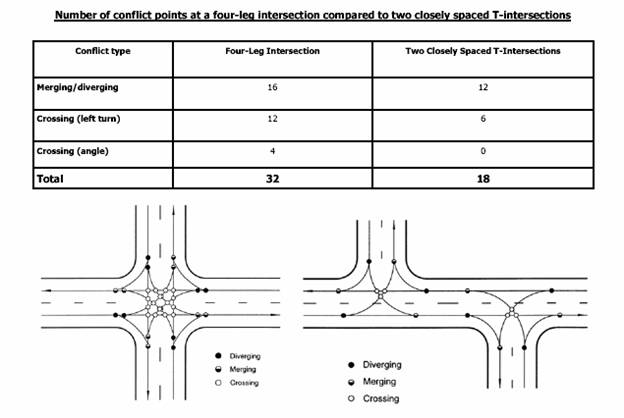
City Engineering Staff recommends that all interior driveways be offset based on the fact that driveways which are not offset have considerably greater potential for accidents. (See attached diagram in Figure 1) Lots 2 and 3, Block Two have a shared driveway which is directly across from the driveway for Lot 3, Block One. This is the driveway which is planned for truck and delivery traffic. Therefore the plan must be revised with these driveways offset.
This development plan provides pedestrian circulation and connectivity. Pedestrian access to the walkway along W 6th Street is desirable but may not be possible due to the change in grade. Pedestrian access will be provided to the residential development to the west by an extension of the center pathway; however additional pedestrian connections to the development on the west will be required when it is developed. The 10’ ped/bike path running diagonally through the site does not connect with the bike path along the east side of George Williams Way. The path must connect to the bike path, either with special treatment of George Williams Way for a crossing, or the path would be extended to the south to meet the 10’ path along W 6th Street. A bike crossing here is not recommended by City Engineering Staff given the distance from the intersection. The bike path must be connected from the exit point on George Williams Way to the bike path along W 6th Street. There are no historic or natural features within the boundary of the proposed development that are adversely affected.
Staff Finding – The proposed Preliminary Development Plan is consistent with the Statement of Objectives of Planned Unit Development with the exception of vehicle and pedestrian circulation features as listed in Objective (3). Three lanes of traffic with a center turn lane, is recommended along Mercato Drive and Overland Drive and all interior driveways are recommended to be offset. The plan should be revised to increase pedestrian access to W 6th from the individual lots, if possible. A note should be placed on the face of the plan stating that additional pedestrian connections to the development on the west will be added when the property to the west is developed. In addition, The 10’ pedestrian/bike path must be extended from its point of exit on George Williams Way to the 10’ path along W 6th Street to provide connectivity.
3) The nature and extent of the common open space in the Planned Unit Development, the reliability of the proposals for maintenance and conservation of the common open space, and the adequacy or inadequacy of the amount and function of the common open space in terms of the densities and dwelling types proposed in the plan.
Major open space is provided in the detention basin, the peripheral boundary, along pedestrian walkways and between the buildings and the street on Lots 1, 2 and 3, Block One. Open space is also provided along the southern sides of Lots 2 and 3, Block One. Per Section 1008(B) a minimum of 20% of the land area devoted to commercial uses shall be set aside and developed for open air, recreational uses and other common open space. The open space must be ‘set aside’ or defined on the plan as well as on site. The open space summary must be revised to reflect the amount of open space which is ‘set aside’ rather than all the pervious surface.
The plan notes that the developer is responsible for establishing ownership and maintenance of stormwater detention areas via individual owner maintenance or maintenance by owners association. A note must also be placed on the plan designating responsibility for maintenance of all open space.
Staff Finding – The proposed Preliminary Development Plan must be revised to note the amount of open space that is being ‘set aside’ for open air, recreational uses and other common open space. The space must be defined on the plan as well as on site. The plan must also note the party responsible for the maintenance of the open space.
4) Whether the plan does or does not make adequate provisions for public services, provide adequate control over vehicular traffic, and further the amenities of light and air, recreation and visual enjoyment.
The building on Lot 3, Block One has a loading area located just off the access point from Mercato Drive. There is concern that the configuration of the parking and loading area may result in traffic conflicts. The applicant will need to verify that the truck traffic and maneuvers will not create traffic conflicts with pedestrians, vehicles or bicyclists or the loading area will need to be relocated. The development plan has a very good open space provision. Common open space is defined by the Zoning Ordinance as open space which is ‘set aside’. The common open space and the public spaces must be marked on the plan and the dimensions listed. Upon review of the plan, Fire/Medical Staff required that fire hydrants be provided and shown on the plan. The hydrants must be added to the plan in locations suitable to the Fire Inspector.
Staff Finding – Applicant will provide confirmation that the loading area for Lot 3, Block One will not create traffic circulation hazards or the loading area will need to be relocated. Common open space and public space must be defined on the plan, as well as on site. Fire hydrant locations must be shown on the plan and approved by Fire/Medical Staff.
5) Whether the plan will or will not have a substantial adverse effect on adjacent property and the development or conservation of the neighborhood area.
The exterior pad site buildings front neither on W 6th Street or Mercato Drive, rather they are positioned with their sides toward the streets. With 4-sided architecture, this orientation should not be detrimental. West 6th Street is a major arterial street and an identified community corridor/gateway. The proposed grading will position the buildings ‘below grade’ along West 6th Street. Adequate landscaping along West 6th Street must be provided to ameliorate the possible negative view of rooftops rather than building facades. Landscaping is proposed along the west property line as a buffer from the abutting proposed residential-office area without separating it from it.
Staff Finding –Appropriate, visually pleasing landscaping must be provided along West 6th Street to enhance the visual appearance of the Gateway.
6) In what respects the plan is or is not in conformance with the development standards and criteria of this article. [The general standards are found in Section 20-1006 and Preliminary Development Plan requirements are listed in Section 20-1010]
Section 20-1006(g) requires the landowner to provide for and establish an agency for the ownership and maintenance of open-air recreation areas and common open spaces where such are to be retained in private ownership. A note must be added to the plan designating ownership and maintenance responsibility for the open space.
Section 20-1006(i)(1) requires that all buildings, structures and parking lots shall be set back from the periphery boundary or periphery street rights-of-way a minimum of 30 feet. The parking area and dumpster in Lot 1, Block 2 are located within the peripheral boundary. These must be relocated or a waiver requested from this provision.
Section 20-1010(8) requires that the use of each building be listed. At this time the applicant is unsure of the exact use of the buildings. A note must be added to the plan stating that no other buildings, beyond those specified for retail commercial use in Phase I and II on this plan’s summary table are allowed to be developed with retail commercial uses.
Section 20-1010(13) requires a schedule showing the proposed timing and sequence within which the applications for final approval of all portions of the Planned Unit Development are intended to be filed.
Staff Finding – The proposed preliminary development plan complies with the general standards in the Zoning Ordinance with some exceptions. The trash dumpster and parking area for Lot 1, Block Two is located in the peripheral boundary and must be relocated, or a waiver must be obtained. A note restricting retail commercial uses to only the buildings listed as retail commercial in the phasing summary must be added. The phasing schedule must include a time schedule for applications for final approval of all phases.
7) In what respects the plan is or is not in compliance with the requirements for application for tentative approval of the Planned Unit Development. [This finding refers to Section 20-1005 of the Zoning Ordinance.]
Staff Finding – Staff has reviewed the Preliminary Development Plan with regard to the requirements for a General Planned Unit Development, Planned Commercial Development, Preliminary Plat Review, and Comprehensive Plan. It is in compliance with most of the requirements and the items that must be changed have been referred to the applicant.
8) The sufficiency of the terms and conditions proposed to protect the interest of the public and the residents of the Planned Unit Development in the case of a plan that proposes development over a period of years.
This will be a phased development. The timing of the phases must be included in a revised phasing schedule. Grading for the proposed development will alter the existing topography of the property. Staff recommends all rough grading be completed in Phase 1 to establish vegetation and reduce site disruption.
Staff Finding – The addition of a timing schedule for the phasing of the development is necessary. The completion of grading of the site with Phase One will reduce the amount of site disruption later and allow vegetation to be established along the streetscapes, primarily West 6th Street. The detention basin must be constructed with Phase One.
9) Stormwater detention calculations and storage of excess stormwater drainage as per City Policy.
The drainage study has been approved by the City Stormwater Engineer. The City Stormwater Engineer required that a drainage path be provided for the runoff created by the grade change along W 6th Street to protect the pad site properties. The Engineer indicated the revised drawings showing the finished floor elevations met this requirement. Public improvement plans for the storm drainage system must be submitted to the Public Works Department for review prior to release of the plan to the building inspector. Occupancy permits will not be issued until the required public drainage improvements are complete, final inspected and accepted by the Public Works Department. No construction activity, including soil disturbance or removal of vegetation, will commence until a stormwater Pollution Prevention Plan (SWP3) has been obtained.
Staff Finding- The drainage study has been approved by the City Stormwater Engineer.
Staff Review and Conclusion
The proposed Preliminary Development Plan conforms to the anticipated land use for this area as stated in the Comprehensive Plan, Northwest Plan and 6th & K-10/South Lawrence Trafficway Nodal Plan . Development of the site will be phased and a timing component must be added to the phasing schedule.

Figure 1. Intersection traffic conflict points
comparison between direct and offset drives.