Date: August
14, 2006
Time: 6:30 to 7:30
pm
Location: Commission Chambers, City Hall
Attendance:
Thirty
(30) community residents, representatives from the Public Advisory Committee,
City Staff, and Consultant Team were in attendance at the fourth public open
house held August 14, 2006 at City Hall from 6:30 p.m. to 7:30 p.m.
Welcome:
§
Dave
Corliss (Interim City Manager) opened the meeting stating that after an
extensive review of possible locations, city staff and consultants are recommending
the acquisition of approximately 530 acres of land bounded on the north and
east by the Wakarusa River and Coal Creek, on the west by East 1600 Road, and a
southern border located between North 1175 and North 1100 Roads. After this public meeting, the City
Commission will receive a report on the public’s comments and concerns related
to the recommended site as well as a status report on possible contracts for
purchase. As land acquisition is
underway, parallel work is being done to identify the collection system corridor
to connect to the existing wastewater system. The next project phases will
include facility design and construction.
§
Dave
Corliss introduced Mayor Mike Amyx who discussed the importance of this project
to the future of
Project Objective and
Introductions:
§
Mike
Orth (Black & Veatch) reviewed the meeting agenda, introduced the project
team, and gave an overview of the Wakarusa Water Reclamation Facility study
process.
Vision
Orth
explained that the City Commission initiated the study to evaluate and
determine the optimum location to construct a new water reclamation facility
along the Wakarusa River, south of Lawrence, to meet current and future
wastewater treatment needs in accordance with the 2003 Lawrence Wastewater Master
Plan. The study focused on the short-term needs of the City but also
envisioned the build-out of the watersheds south of the
 Sites and
Criteria Considered
Sites and
Criteria Considered
o
Orth
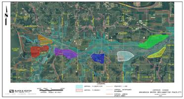
said that seven sites were investigated for the new facility. These sites were identified as viable due to
their topography, usability, ability to receive gravity flow, and capability to
connect with utilities such as water, power, natural gas, as well as necessary
transportation routes.
o
Orth
explained that leaders representing varied interests within the
•
Odor
control
•
Stream
impacts
•
Fit
with future land use
•
Maximizes
use of existing infrastructure
•
Service
area by gravity
Cost Benefit Analysis of Alternatives
o
Orth
explained that each of the sites and process footprint alternative combinations
was ranked by the PAC/City staff according to the criteria. In addition, 20-year present worth costs were
developed for each combination. The
comparison considered construction and operation and maintenance (O&M)
costs as well as the ability of a given site to meet the criteria developed by
the PAC and City staff. The purple and white sites emerged as the highest ranking locations for further
investigation, providing the highest value for the lowest cost.
On-Site Investigations
o
Orth
explained that the on-site investigations did not identify any “fatal flaws” on
either of the two highest ranking site alternatives. The appraisals determined that nominally 500
acres could be purchased at the white location for less than the purchase of
slightly over 300 acres at the purple location.
On-site investigations indicated the following for the two highest
ranking sites:
|
Investigation |
White
Site Findings |
Purple
Site Findings |
|
Phase I
Environmental |
No significant findings |
|
|
Phase II
Cultural Resources |
No archeological or architectural finds deemed
eligible for National Register of Historic Places (NRHP) |
|
|
Wetlands |
Facility footprint can accommodate small wetlands
located in SE of site |
None in proposed facility footprint |
|
Threatened and
Endangered Species |
None identified. Wildlife – Conditions in small area on each site
potential habitat for Redbelly Snake. Plants – Nothing significant, previously
cultivated |
|
|
Geotechnical |
Not a differentiator – highly similar soil |
|
|
Appraisal |
Lower total land cost |
Greater total land cost |
Discussion of Top Two
Alternatives
o
Orth
said that aside from the increased cost in land acquisition, the purple site is
not the optimal location due to several physical site characteristics that
reduce its flexibility and usability, leading to less optimal design
possibilities, higher project costs, as well as potential schedule
implications. Another significant factor
is the proximity of existing development to the northeast in the direction of
prevailing winds that may carry any odors from the facility directly over a
greater population density than the white site.
o
Orth
said that the white site best fulfills a combination of the noted criteria, as
well as other factors identified by staff, the PAC, and the public. It is bordered on the north and east by
floodway, a natural barrier from future development. As a result, the location of a water
reclamation facility within the white site provides a good fit with current
land use and future land use projections of vacant/farming activities due to
its floodplain location. In addition, fewer neighbors are currently located in
close-proximity to the potential facility than in other areas considered and no
residents require relocation from their homes.
The white site is also well-positioned between critical facilities, such
as Four Seasons Pump Station and the existing Kansas River Wastewater Treatment
Plant, allowing the use of existing infrastructure to be maximized.
 Optimal
Site Recommended
Optimal
Site Recommended
o
Orth explained that the white site has
a number of attributes which make it the most desirable location upon which to
construct the currently proposed facility and expansions. Using a map of the optimal site, Orth described its
proposed layout. He explained its
factors and features and advised why it was selected. He noted its:
•
Relative
isolation from existing and future development.
•
Impact
on fewer property owners during acquisition and no residences to acquire.
•
Favorable
location with respect to odors potentially carried by prevailing winds.
•
Lack of
restrictions provide increased flexibility to accommodate varied process
footprints.
•
Central
location with regard to existing infrastructure.
•
Neutral
location to the South Lawrence Trafficway.
o
He
also explained that Kansas Department of Health and Environment’s siting
criteria required the City to locate a potential odor generation point no
closer than 1000 feet to an existing home, but the City does not need to own that
property.
Open House & Next Steps:
§
Orth
explained that the remainder of the meeting would be an open house organized
into three discussion areas or stations:
odor concerns, location issues, and
§
Debbie
Van Saun (Assistant City Manager) offered those interested in a tour of the
existing plant should contact Dave Wagner (Assistant Director, Wastewater).
Open House Results:
Questions
and comments collected during the meeting and the responses provided to them are
outlined below and organized according to issue. Italicized text indicates a summary of the response provided
to the question offered by the public.
Site
Criteria
o
One
resident questioned why the purple site was deducted due to issues relating to
“gateway to the city” while the white site was not deducted for this reason
when it is potentially adjacent to the SLT which would have more traffic.
•
The individual
was told to reference the full report on the website, which provides the
following information about the revision of criteria scores based on the
proximity of the potential
The table below shows the criteria rankings which
changed as a result of consideration of the SLT alignment, designated “White-2”.
|
Criteria |
White |
White-2 |
Comments |
|
Aesthetics |
4 |
3 |
The SLT is a bypass around the City and does not
have the same gateway issues as Hwy 458.
However, the SLT located at the 42nd Alignment will still bring
traffic closer to the WRF than previously considered, potentially requiring
greater aesthetic compensation. |
|
Traffic
Considerations |
2 |
4 |
Without consideration of the SLT, the White Site
is fairly isolated from a transportation standpoint. The location of the SLT near the WRF would
actually improve transportation logistics, so this criteria ranking was
increased. |
|
Usability/Shape |
5 |
3 |
Clearly, the presence of the SLT would reduce
some of the layout flexibility of the White Site, but not to the same degree
that the Purple Site is impacted by Hwy 458. |
The reason the
potential SLT alignment does not have a significant impact upon the benefit
score of the white site is because it does not alter the categories which had
the most significant weight contributions to the decision, such as stream
impacts, odor control, and fit with land use.
Proximity
of Optimal Site to Nearby Homes
o
An
adjacent property owner is concerned that the site will continue to move closer
to their property/house.
•
It was explained
to the resident that the facility footprint shown is for the ultimate build-out
(50 mgd) of the site and Kansas Department of Health and Environment requires a
1000-foot buffer around the facility from existing homes. In addition, the City is acquiring additional
property that will serve as additional buffer for the facilities. The ultimate use of that buffer area has not
been determined yet.
o
Where
is the closest house in relation to the proposed facility?
•
The closest
houses to the proposed facility footprint are just over 1000 feet northwest
from the proposed footprint, north of the
Uses for
the Buffer Portion of the Site
o
Several
questions on what would be done with the unused portion of the property were
received. A hike and bike trail was a
popular suggestion. Also suggested was
building a lake as a means of floodplain mitigation for raising the site.
•
Residents were
told that the next phase of the project would involve looking at possible
community benefits that could be incorporated into the site. Representatives of the PAC will continue to
the follow the project and will provide a community voice on this topic. It was also acknowledged that additional uses
for the surrounding area would need to be a community decision as it would add
cost to the project and require collaboration with other City and community
organizations, such as the
Access
o
Near
resident concerned about the removal of access restrictions on 1175 Road due to
the fact that people (mainly kids) will mill around late at night. Resident would like west access to remain
blocked.
·
The design team will
consider controlled access to the site.
o
Near
residents were also concerned about access to site during construction and normal
operation. What will be future access
from N. 1100 Road? Will this serve as
the primary access to the facility?
•
Residents were
told that it is possible that N 1100 Rd will be utilized as the primary
east/west traffic route to E 1600 (O’Connell) to provide access to the site.
Annexation
o
Is
the City planning to annex property beyond that included in the 530 acre
proposed site? Are you planning to
access property from
The City does not intend to immediately annex any
additional property beyond the plant site.
At some time in the future, the entire Urban Growth Area may be annexed
into the City as dictated by development trends.
Flooding
and the Floodplain
o
Residents
expressed concern about Coal Creek and the
•
Residents were
told that the City would comply with its own stormwater control
regulations. Any facility constructed by
the City will not be allowed to create additional flooding. However, the Wakarusa Water Reclamation
Facility will not correct any existing flooding of low ground.
•
With regard to
the floodplain, FEMA regulations allow construction in the floodplain as long
as the 100-year flood water level is not increased by more than one foot.
•
City regulations
are stricter and do not allow any rise in the floodplain for future
development.
•
Possible examples
of mitigation include land purchased off-site and not developed, improved flow
characteristics, excavate adjacent area, replace lost area in floodplain, and
channel improvements to the river. The
specific mitigation plan has not yet been determined as design is not far
enough along to know the exact point of discharge or definite site
impacts. It is likely that mitigation on
the site will occur as the facility expands rather completing all the mitigation
initially due to cost considerations.
However, additional study is required to verify this approach.
•
The existing
•
Historical flows (post
o
Residents
were curious what would be their “guarantee” that the project would not cause a
rise on the
•
The Corps of
Engineers will review the hydraulic model in the permitting process.
o
Residents
were similarly concerned about building in the floodplain – both for potential
impacts on the facility as well as existing property in the area.
•
The facility will
be built within the floodplain, but not the floodway.
•
This location is
similar to that of the
o
Why
is the City able to get a permit to build in the floodplain when I was not able
to get a permit to build on my personal property?
•
The same
construction regulations with floodways and floodplains exist for the City as
for any citizen.
o
Where
will site fill come from?
•
Where possible,
on-site suitable material excavated for floodplain mitigation, will be used. We
will be constructing facilities and roadways on the fill material, so strict
engineering properties and quality assurance/quality control will be
required. If the quality or quantity of
material can not be found at the site, suitable fill material will be brought
in from a borrow area.
o
Residents
questioned if water levels following rain events were really understood.
They mentioned that sometimes a detour around
flooded areas is required and that, at times, the water has been high enough to
cover a large John Deere tractor.
·
The proposed site elevation
is below the 100-year flood event and the site will need to be elevated to
protect the facilities from flooding.
o
An
area resident stated that a 7” rain event causes flooding in these fields. Area has flooded many years, wiping out
crops.
·
The Wakarusa Water Reclamation
site is in the 100-year floodplain and is prone to flooding.
o
The
·
The proposed discharges
from the Wakarusa Water Reclamation Facility are less than historical flows on
the river.
o
I
am concerned about the flooding. Without
an impact study, you have no idea how it is going to affect farmland or our
animals (wild and tamed). Personally, I
don’t think you care. All you want is to
control!
·
The Corps of Engineers and
the City stormwater regulations will require hydraulic modeling of the site and
its discharges to evaluate the implications on the river and its water
surface. The Kansas Department of Health
and Environment will also dictate the effluent quality of the new facility.
Sewer
o
A
near resident wondered if she would be assessed for sewer lines on her
property. Several other residents expressed concerns about the routing of the
sewer lines and the proximity of the new lines to their homes.
•
We are in the
process of beginning a study to determine the most appropriate corridor for the
sewer lines to connect the new facility with existing and new sewer
infrastructure, so specific routings have not yet been determined. Where possible, routings will be along the
right-of-ways of roadways to avoid any impact on personal property. However, in some cases, sewer lines may need
to be routed on personal property. In
these cases, the City will have to purchase a right-of-way from the property
owner on which to locate the sewer infrastructure. The property owner would still be able to use
the right-of-way portion of the property, but would need to allow access by
City personnel for the construction and maintenance of the pipeline. There may be restrictions of use included
with the easement that will be negotiated with the property owner.
•
Currently, the
sewer corridor study is expected to run through early 2007. Public meetings will be held to update the
public, obtain input, and apprise them of the status of the work as it
progresses.
•
Existing property
owners will not be assessed for the sewer construction. The cost of this construction has been
included in the planned rate structure for the city wastewater customers. If future development wants to provide access
to City sewers, developers will be assessed a fee to connect to the city
sewers.
Effluent
o
One
resident commented that at one time the
•
It was explained
to the resident that it was true that the
o
What
will be the quality of the effluent water from the new WWRF?
•
Kansas Department
of Health and Environment sets permit limits so the additional discharge will
not have a negative impact on the quality of the river and associated flora and
fauna. Often, Kansas Department of Health and Environment requires that the
effluent water quality be higher than the existing stream quality.
•
Effluent standards
will likely be 8 mg/L nitrogen and 1.5 mg/L phosphorus. The permit will also likely include limits on
pH, suspended solids, biological oxygen demand (BOD), and chlorine. Kansas Department of Health and Environment
will conduct an Anti-degradation Study of the Wakarusa and provide a report to
the setting establishing the water quality limits.
Sludge,
Biosolids, and Disposal
o
Attendees
wanted to understand the sludge, or biosolids, disposal options.
•
The disposal
options include conveying to the City’s existing wastewater treatment plant for
processing or to treat it at the Wakarusa site.
A final determination has not been made yet.
•
The City
currently generates a Class B biosolid, which is suitable for land
application. The current disposal program
utilized by the City allows for the beneficial reuse of the biosolids over a
relatively wide geographic area and has, in the past, applied materials even in
other counties. The current demand for the material exceeds our ability to
supply the biosolids. As chemical
fertilizers use fossil fuel as a raw material, the value of organic products,
such as biosolids, may likely increase.
•
The City may
elect to maintain the buffer area as leased farm ground and apply a portion of
the biosolids at agronomical rates to fertilize the planted crops surrounding
the new Wakarusa facility. The City
complies with the Environmental Protection Agency’s (EPA) land application
program, which is heavily regulated to protect public health.
o
Is
the County in agreement with the plans for the new Wakarusa Water Reclamation Facility,
including biosolids disposal options?
•
The
o
What
happens when biosolids get wet? Will
they impact my well?
•
The application
of biosolids to agricultural land is heavily regulated by the Environmental
Protection Agency (EPA). The City of
Wetlands
o
A
resident wondered if there would be any impact on existing wetlands by the
facility.
•
The resident was
told that while three small (largest is less than 2.5 acres) wetlands areas
were found on the 530-acre site during the course of on-site investigations,
none of the areas would be disturbed by the facility footprint. The proposed facility location was actually
shifted northwest from the original location to avoid any impact on the discovered
wetlands.
Fishing/Wildlife
o
Will
fishing be allowed in the Wakarusa after the facility is built?
•
The Kansas
Department of Health and Environment will complete an Anti-degradation study
with the aim of setting permit limits to prevent harm to the stream, plants,
and aquatic species. The City will meet
these standards. Fishing will not be
restricted due to the plant location.
.
o
A
question arose about what would happen to beavers that live on the river.
·
Regardless of the plant location, it is
important to maintain a flowing channel in the
Costs
o
An
adjacent property owner asked for the cost difference for odor control between
the purple and white sites.
·
We have estimated $1 million dollars of
additional cost will be required at the purple site than the white site. Refer to Table 3 of the Wakarusa Water
Reclamation Facility Report found on the City’s website.
o
An
area resident asked for the charge, repair, and answer lifecycle costs for the
white and purple sites.
·
We have estimated that the small purple site will
cost approximately $24 million dollars more to operate and maintain than the
medium white site. Refer to Table 3 of
the Wakarusa Water Reclamation Facility
Report found on the City’s website.
Odors
o
An
adjacent property owner asked if a city survey had been conducted of the local
population regarding plant odors at the existing facility.
·
No specific survey has been
completed. The best indicator would be
the number of odor complaints received for the
o What distance can odor travel? Is it site specific?
·
There is no
straight-forward answer to this question.
The distance that odor can travel is dependant upon surrounding
conditions as well as site characteristics, such as wind speed and direction,
temperature, and site topography. The
best way to estimate odor impacts of the new facility is to use the existing
plant as a reference point. Travel the
distance and direction from the existing plant that you are interested in and observe
odors. Do this on a variety of days
under varied weather conditions to get an idea of the odor conditions at that
location.
o
A
resident stated that existing neighbors of the existing plant complain now of
odor.
·
The City is committed to
being a good neighbor. They are
considering the purchase of additional buffer area to control odors, as well as
process and ventilation enhancements to address concerns.
Site Size
and Location
o
Residents
asked general questions regarding how big the site would be and in what
direction might it expand in the future?
·
The initial phase of the
facility will treat a capacity of 7 mgd and occupy roughly 20 acres.
·
The ultimate phase of the
facility will treat a capacity of 50 mgd and occupy roughly 60 acres. The initial phase of the construction
requires more area per mgd capacity treated due to the need for shared
infrastructure to be built in the beginning.
·
Additional site planning
work is required to address how the site will be developed.
o
An
adjacent property owner stated that all things considered, due to density and
other factors it appears to be a good choice.
·
Given the stakeholders
concerns, the proposed site best addresses the issues.
Property
Values
o
How
are property values determined by appraisers?
·
The
o
How
is this going to affect our property value?
·
If potential buyers believe that the water
reclamation facility will emit odors, be noisy, create flooding concerns, and
pollute the river, they will be less likely to buy property in proximity to the
facility. On the other hand, if the facility is not built, there will be no new
development in
General
Comments:
o
Historic
sites in the area that are not on the books include the Santa Fe Trails and
former African-American settlements.
·
The City has
conducted a Phase I and II Cultural Resources Survey of the proposed site. Refer to the City’s website for the reports,
which are found in Part 2 of the report.
o
What
type of soil is found on the recommended site?
•
This site has
basically the same soil composition common within
o
When
will the construction start?
•
Based upon the
current schedule, construction will likely start in early 2009 and the facility
will be operational in 2011.
o
Will
a tax increase be required to fund this project?
·
Existing property
owners will not be assessed for the facility or sewer construction through a
tax increase. The cost of the
construction has been included in the planned rate structure for the city
wastewater customers.
o
Do
the Environmental Protection Agency (EPA) regulations specifically cover
wastewater facilities?
•
Yes, Kansas Department of Health and
Environment has the enforcement authority for the regulations on behalf of the
EPA.
o
How will you bring flows across the river?
·
Kansas Department of Health and Environment has already indicated that consideration should be given to
tunneling any crossing of the
o
An
adjacent property owner agreed that for the City, the site is a good location,
but wished that it was not adjacent to their home.
·
The siting study
attempted to consider many factors in selecting the optimum location for the
facilities.