|
PLANNING COMMISSION REPORT SUMMARY Regular
Agenda -Public Hearing Item |
|
PRELIMINARY DEVELOPMENT PLAN FOR PRAIRIE
WIND SINGLE FAMILY HOMES; |
PDP-05-04-06: Preliminary Development Plan for Prairie Wind Single Family Homes. This
proposed planned residential development contains approximately 3.04 acres and
proposes 17 single-family detached homes.
The property is generally described as being located at
|
STAFF
RECOMMENDATION: Planning
staff recommends approval of the Preliminary Development Plan based upon the
findings of fact presented in the body of the Staff Report and subject to the
following conditions: 1.
Provision
of a revised Preliminary Development Plan to: a.
include
a statement as to the substance of the covenants pertaining to the
maintenance of common areas and grants of easements or other restrictions to
be imposed upon the use of the land; buildings and structures, including
proposed easements or grants for public utilities; b.
provide
a note that occupancy will occur after the project is completed, or if the
homes are to be occupied as they are completed that all public improvements
and site improvements must be complete before occupancy may occur; c.
list
the measures to be used during construction for protection of existing trees; d.
revise
General Note No. 10 on the plan to include ‘maintenance of common drives’ as
a responsibility of the Homeowner’s Association; e.
relocate
the common open space from the access way to an acceptable location in the
interior of the site; revise the amount of common open space in the General
Site Summary, if necessary. f.
show
the required ‘ g.
designate
responsibility for regulating playtime for the basketball court in the
northwest corner and other common play areas with the Neighborhood
Association and covenants. h.
show
the right-of-way dimension for i.
show
dimensions of individual easements separately; remove any references to
combined right-of-way and utility easement. j.
note
that the uses in this PRD are restricted to single-family detached units. k.
note
that the existing water well will be plugged to Kansas Standards; and l.
provide
correct legal description by replacing reference to 88 deg, with 89 deg. m.
remove
utility easement from detention basin n.
correct
the reference in the Landscaping section to read ‘Master Street Tree Plan
that will be filed with the Final Plat, rather than ‘has been filed’. 2. Approval of the preserved
tree list and protection measures to be employed during construction by the
City Landscaping Supervisor. 3. Revisions to the grading plan, submitted
and approved by City Stormwater Engineer, to: a.
define
the drainage area along the south edge of the property so it flows into the
area inlet. b.
define
the drainage along the east edge of property so it flows into the detention
area; c.
overflow
from the detention area must flow into the street and not directly into the
backyard of the property to the east of the detention area. |
|
Reason for
Request: |
Development of a one lot Planned Residential District with 17 single-family
residential homes. |
|
KEY POINTS ·
This
property is unplatted. The Preliminary Development Plan serves as the
Preliminary Plat for the property. ·
3
waivers are being requested with this plan, 2 for reduction of the required 35’
peripheral boundary along the north and south boundaries and 1 to allow the
development to have direct access to a local street. ·
This
property is located in an established residential area with primarily
single-family and limited multi-family residences. |
|
|
FACTORS TO CONSIDER ·
Conformance with the purpose and intent of
Planned Unit Developments (Section 10-1001). ·
Compliance with Zoning Code. ·
Conformance with Horizon 2020. |
|
|
ASSOCIATED
CASES/OTHER ACTION REQUIRED ·
Future submission of a
final plat; approval and recording required. ·
Future submission of a
Final Development Plan; approval and recording required. ·
Public Improvement Plans
submission to City Public Works Department. ·
Recording of covenants
governing maintenance of all common space. ·
A
rezoning of this area from the RS-2 (Single-Family Residence) District to the
PRD-1 (Planned Residential) District (Z-05-12-06) is being considered
concurrently with the preliminary development plan. ·
Previous Rezoning Requests: Z-09-61-05; RS-1 to RM-D; 3 acres; rezoned
to RS-2 using lesser change table. Approved by WAIVERS REQUESTED 3 waivers are being requested with this PRD. The following 2 waivers are requested from Section 20-1007E(2)
Periphery boundary requirements: ·
Reduction
of the required Periphery Boundary along the entire Northern border of this
parcel from 35’ to 25’ ·
Reduction
of the required Periphery Boundary along a 140’ portion of the southern border
of this parcel from 35’ to 30’, as shown. The following waiver is being requested
from Section 20-1006 (b) General Development Standards – Planned Unit
Developments. §
allow
the PRD to have direct access to a
local street, |
|
|
PUBLIC COMMENT RECEIVED
PRIOR TO PRINTING ·
None
received. |
|
GENERAL INFORMATION
|
Number of
lots: 1 Gross Area: 3.35 Gross Acres Right-of-Way 0.76 Acres Net Residential Area: 2.59 Net Residential Acres Number of Residential Structures 17 Single-family Residential Homes Number of Dwelling Units: 17 Dwelling Units Maximum
Density in PRD-1 7 Dwelling
Units/Net Residential Proposed
Density in PRD-1 6.56 Dwelling
Units/Net Residential Common Open Space Required: 0.51 acre (20% of net residential land) Common Open Space Provided 0.51 acre of open space Off Street
Parking Required 34
spaces (Parking group 1, 2
spaces/unit) Off Street
Parking Provided 34 spaces |
Development History: Prairie
Wind PRD
The property is the remaining portion of a farmstead and has not been
platted. The remainder of the farmstead (approximately 17 acres) was platted
and rezoned to RS-1 and RM-1 in 1978. A rezoning request from RS-1 to RM-D for
the subject property was considered by the
The proposed Preliminary
Development Plan for Prairie Wind has been evaluated based upon findings of
fact and conclusions per Section 20-1010.1 of the Zoning Ordinance for the City
of
1) In what
respects the plan is or is not in general conformity with the provisions of the
Comprehensive Plan of the City.
The development proposes 17 single-family homes to be developed on one lot. The homes and the land beneath them can be owned individually; however, the remaining land and driveways will be under common ownership. The applicant indicated that this may create affordable priced housing.
Horizon 2020 encourages a mixture of housing types, styles and economic levels for new residential and infill developments. Compatible densities and housing types are also encouraged in residential neighborhoods.
The density being proposed (6.56 units per net residential acre) is slightly higher than that in the surrounding zoning districts. The RS-2 district allows 6.22 units per acre, the RS-1 district allows 4.36, the RM-D and the RM-1 multi-family districts allow 12.43 units per acre. These areas surround the subject property and are shown on the accompanying graphic. (Figure 1)
Horizon 2020 encourages development of neighborhoods in a range of densities to provide a sense of community and to complement and preserve natural features in the area. (page 3-1) Map 3-2 of Horizon 2020 identifies this area as a ‘very low-density to low-density residential district’. Horizon 2020 discourages concentrations of high-density, multiple-family infill within neighborhoods in Policy 3.3e, and defines low density residential development as 6 units per acre or less and medium density residential development as 7 to 15 units per acre. (page 5-3)
Natural and environmental features within residential areas should be preserved and protected. Natural vegetation and large mature trees in residential areas add greatly to the appearance of the community as a whole and should be maintained. (Policy 5.1)
The Prairie Wind Planned Residential Development will maintain a similar density and land-use (single-family residential) as the surrounding area. The proposed density is between 6 and 7 units per acre, which lies between the defined densities for low and medium residential densities. The housing types shown on the preliminary development plan are compatible with the existing housing stock. The final development plan must indicate that the housing architectural features will be of a sort that the development will blend with the surrounding neighborhood rather than stand apart as a separate unit. The plan, as conditioned, would preserve natural and environmental features which are significant aesthetic amenities of the area. The large stands of trees and the mature trees located on the site must be preserved to maintain the character of the area.
Staff Finding – The proposed development is an example of infill
development as the surrounding areas are developed residential neighborhoods.
The proposed development complies with the general land use provisions found in
Horizon 2020. The proposed
development plan, as conditioned, will also comply with Horizon 2020 in the creation of a functional and aesthetic living
environment.
2) In what respects the plan is or is not consistent with the Statement
of Objectives of Planned Unit Development? (The statement of objectives of
planned unit developments is found in Section 20-1002 of the Zoning Ordinance]
The proposed development complies with the four stated objectives for planned unit developments. The density and intensity of use are compatible with Horizon 2020. The proposed development will be served by existing utilities. Any utilities that must be provided will be installed with private financing. Efficient vehicular and pedestrian circulation is provided on site. Sidewalk connections are being provided to the Haskell walk at both the north and south ends of the project. Access is taken from a local street and is prohibited from the adjacent major arterial street. There are natural features within the boundary of the proposed development that should be preserved with this development.
Staff Finding – The proposed Preliminary Development Plan is consistent with the Statement of Objectives of Planned Unit Development with the exception of the preservation of natural features (Objective 4). The plan must be revised to note the protective measures to be employed during construction. A waiver must be obtained to allow the development to have direct access to a local street rather than a major thoroughfare or collector.
3) The nature and extent of the common open
space in the Planned Unit Development, the reliability of the proposals for
maintenance and conservation of the common open space, and the adequacy or
inadequacy of the amount and function of the common open space in terms of the
densities and dwelling types proposed in the plan.
The area will consist primarily of common space. Only the homes and the land beneath them will be privately owned. Common open space is defined in the Code as land within the site designated for a Planned Unit Development which is designed and intended for the use and enjoyment of all the residents. Section 20-1006(g) further defines common open space as ‘an open area designed and developed primarily for the use and benefit of the residents of the development for recreation (whether private or public, courts, gardens or parking for open space uses; it shall not include space devoted to streets and parking for residential uses.
Staff Finding –The Preliminary Development Plan has marked adequate
areas as common open space; however, the portions which lay along the private
access drives at the end of
4) Whether the plan does or does
not make adequate provisions for public services, provide adequate control over
vehicular traffic, and further the amenities of light and air, recreation and
visual enjoyment.
The Fire Code requires a 50’ radius turn-around at the end of a dead-end street that measures more than 500’ in length. The extension of Ryan Court is less than 500’, so the street design is acceptable with the provision that ‘Fire Lane’ and ‘No Parking’ signs must be placed on both sides of the private access drives for a distance of 20’. The common open space and the preserved tree cover will further recreation and visual enjoyment.
Staff Finding – The proposed Preliminary Development Plan provides vehicular circulation. The plan must be revised to show the required signage on the private access drives.
5) Whether the plan will or will not have a substantial adverse effect
on adjacent property and the development or conservation of the neighborhood
area.
The property contains considerable tree cover and much of this must be preserved to maintain the aesthetic character of the area. A basketball court is proposed in the northwest corner on the private access drive. This is near a single-family residence and its use may have an adverse effect on the adjacent property. Playtime for this court and all common play areas should be regulated through the Homeowners Association and covenants.
Staff Finding – The removal of the tree cover and the creation of a basketball court near the northern property line may have an adverse effect on adjacent property. The plan must be revised to list the protection strategies to be used during construction. The use of the basketball court must be regulated by the Homeowner’s Association and covenants and this must be noted on the plan.
6) In what respects the plan is or is not in conformance with the
development standards and criteria of this article. [The general standards are
found in Section 20-1006 and Preliminary Development Plan requirements are
listed in Section 20-1010]
Staff Finding – The proposed development plan complies with
the applicable requirements of the Zoning Ordinance with two exceptions: access
and peripheral boundary.
The development plan proposes taking access from a local street rather
than a major thoroughfare or collector as required by Code. The proposed
peripheral boundary along the northern property line and a portion of the
southern property line is less than required by Code. Waivers are being requested
with this development plan for these exceptions.
7) In what respects the plan is or is not in compliance with the
requirements for application for tentative approval of the Planned Unit
Development. [This finding refers to Section 20-1005 of the Zoning Ordinance.]
Staff Finding – Staff has reviewed the Preliminary Development Plan with regard to the requirements for a General Planned Unit Development, Planned Residential Development, and Preliminary Plat Review. It is in compliance with most of the requirements and the items that must be changed have been referred to the applicant.
8) The sufficiency of the terms and conditions proposed to protect the
interest of the public and the residents of the Planned Unit Development in the
case of a plan that proposes development over a period of years.
Staff Finding - No phasing is associated with the proposed development.
If occupancy of homes is planned as they are completed, it will be necessary
for all public improvements and site improvements to be completed before
occupancy. A note to this effect must be placed on the plan.
9) Stormwater detention calculations and storage of excess stormwater
drainage as per City Policy.
Staff Finding- The drainage study has been provided to the
City Stormwater Engineer for review and was approved with conditions. Revisions
must be made to the grading plan to define the drainage along the south edge of
the property that flows into the area inlet, and the drainage along the east
edge of property so it flows into the detention area. Overflow from the
detention area must flow into the street and not directly into the backyard of
the property to the east of the detention area. These changes must be made to
the grading plan and approved by the City Stormwater Engineer.
Staff Review and Conclusion
The proposed Preliminary Development Plan conforms to the land use for this area as stated in the Comprehensive Plan.
The property is located on the east side of
There is a farmhouse and outbuildings that are planned to be
demolished. There is a windmill which will also be removed. The abandoned water
well must be plugged per
The property includes mature tree rows along the western and southern
property lines and mature trees are located about the property (Figures 2 and 3).
The heavy tree cover located on this site is an amenity to the area. One
objective of a Planned Unit Development is to promote design flexibility to
encourage innovative and imaginative approaches to development which will
result in a more efficient, aesthetic, desirable and economic use of land. The
use of creative and innovative design in this Planned Unit Development would
allow residential development to occur while retaining much of the mature tree
cover on site. The buffers created by
the trees along the south and west property lines must be preserved, as much as
possible. The existing tree stands and mature trees must be preserved wherever
possible. A tree preservation plan must be presented and approved as a
condition of approval of this preliminary development plan.
Access to the development would be accomplished by the extension of
In a PRD-1 zoned area, attached and detached residential units are
allowed along with non-residential uses of a religious, cultural, educational
and recreational character designed to serve the residents of the PRD and
commercial uses to the extent that they are intended to serve primarily the
residents of the PRD. A note shall be added to the face of the Prairie Wind PRD
plan to restrict the permitted uses to only single-family detached residential
units.
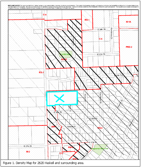
Figure 2. View of trees along the south property
line, 2620 Haskell.
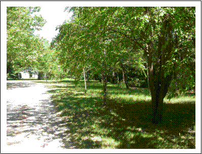

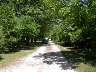
Figure 3. Tree
cover located on the site at 2620 Haskell.