SITE PLAN REVIEW
July 11, 2006
Note: This
item was deferred from the
Additional
items which have been submitted since the June 6 meeting include (see attached):
Attachment
A.
Attachment
B. June 29, 2006
E-mail from Michael S. Almon with a draft copy of conditions to apply to zoning
classification, proposed by the Eastside Neighborhood Coalition; and
Attachment
C. Copy of a
petition asking the City to rezone the Salvation Army site to require a Use
Permit before Site Plan Approval, received by the City Clerk on
At the
June 6, 2006 meeting, the City Commissioner discussed the additional of a 7th
possible condition, “7. The Salvation Army would not pull a building permit
prior to
A.
SUMMARY
SP-03-27-06: A site plan for a Salvation Army
Community Complex to be located on the west side of
B. GENERAL INFORMATION
Current Zoning and Land Use:
M1-A (Light Industrial) and M-2 (General
Industrial) Zoning Districts; Vacant undeveloped
parcel.
Surrounding Zoning and Land Use:
·
M1-A
(Light Industrial) and M-2 (General Industrial) Zoning Districts to the north;
·
M2
(General Industrial) Zoning District to the west;
·
RO-2
(Residence-Office) and M-2 (General Industrial) Zoning Districts to the south;
·
RS-2
(Single-family Residential) District to the east;

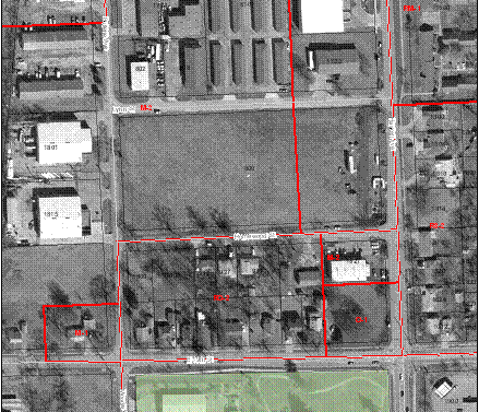
Salvation Army Site, Spring
2003 Aerial
Block on West side of Haskell Avenue, (Haskell
to Bullene)
(
Site Summary:
Legal Description: Tract 1, Lots A and B in Block 5 of Scotts
Replat of portions of Block 5 and 9 in Homewood Gardens, a suburban addition in
the City of Lawrence, Douglas County, Kansas; and Tract 2, Lots 7 through 22 in
Block 5, Homewood Gardens Suburban Addition in the City of Lawrence, Douglas
County, Kansas.
The property is
bounded by
Use Group – 7. Community Facilities. Church or
other place of worship, Halfway house or service-oriented rehabilitation center
or residence, and Rehabilitation center for persons with disabilities.
IMPERVIOUS SURFACE SUMMARY
Existing
Buildings 0 S.F. Proposed
Buildings 34,645 S.F.
Existing
Pavement 0 S.F.
Proposed Pavement 61,311 S.F.
Existing
Impervious 0
S.F. Proposed Impervious 95,956 S.F.
Existing Pervious 157,410
S.F. Proposed Pervious 61,454 S.F.
Existing Site Area 157,410 S.F. Site
Area 157,410 S.F.
New
Right-of-Way 12,830
SF New Right-of-Way 12,830 S.F.
---------------------------------------------------------------------------------------
Original
Site Area 170,240 SF Original
Site Area 170,240 S.F.
Parking Group
Church,
Parking Group 8 - 1 parking space for each 4 seats in Sanctuary. Main Sanctuary
capacity = 160 seats. 160/4 = 40 parking spaces required. 70 parking spaces
provided around church area including 4 accessible.
Booth
Center, Parking Group 6 - 1 parking space for each 3 beds. 66 bed capacity.
66/3 = 22 parking spaces required. 35 parking spaces provided around
Total Site
Parking Required = 62 parking spaces
Total Site
Parking Provided = 105 parking spaces including 8 accessible parking spaces
C. STAFF
REVIEW
The site is a
vacant block located along the west side of Haskell Avenue from Lynn Street to
Homewood Street and is within the M1-A (Light Industrial) and M-2 (General Industrial)
Zoning Districts.
The proposed
use of the Salvation Army Community Complex is two buildings on this site.
I. Building
one is the Salvation Army Family Resource Center – 21,284 square feet. Building
One:
The site plan
review considered each of the two zoning districts in relation to the site
layout.
A previous
site plan for the Salvation Army at this location [SP-04-21-04] was approved by
the City Commission on
The Salvation
Army has provided an attachment to the site plan expressing their commitment to
the community (see attachment A) which they are offering to be made a part of
this site plan.
The property
owner has met with neighborhood representatives to discuss the proposed operation
and conditions for the facility.
D. Findings
Per Section
20-1432 Staff shall first find that the following conditions have been met:
(a)
That the
proposed use is a permitted use in the district in which the property is
located;
The property
is within M1-A (Light Industrial) and M-2 (General Industrial) Districts.
Per Section
20-809, a Church (Use Group 7) is a permitted use in both the M1-A and M-2
Zoning Districts, subject to an approved site plan.
Section
20-1448 states, “When a halfway house or service-oriented
rehabilitation center; health center, government operated; rehabilitation center for persons with
disabilities; a club or lodge, private, except those whose chief activity
is carried on as a business; private
recreation facility or theatre, live (if indoors) is located in a commercial or industrial
zoning district, the requirement for a Use Permitted upon Review criteria shall
not be applied. The site planning requirement shall apply to all uses listed in
this section.” (emphasis added)
Per Section
20-1448, the Salvation Army “
Per Section
20-1428, “The purpose and intent of requiring site plan approval is to
encourage the compatible arrangement of buildings, off-street parking,
lighting, landscaping, pedestrian walkways and sidewalks, ingress and egress,
and drainage on the site and from the site, any or all of these, in a manner
that will promote safety and convenience for the public and will preserve
property values of surrounding properties.”
(b)
That the
proposed arrangements of buildings, off-street parking, access, lighting,
landscaping and drainage is compatible with adjacent land uses;
The site plan
has been reviewed for conformance with the requirements of the site planning
process. A photometric plan has been provided and approved. The proposed
arrangement of buildings, off-street parking, access, lighting, landscaping,
and drainage will be compatible with the adjacent land uses.
(c)
That the
vehicular ingress and egress to and from the site and circulation within the
site provides for safe, efficient and convenient movement of traffic not only
within the site but on adjacent roadways as well;
The vehicular
ingress and egress to and from the site and circulation within the site help provide
for safe, efficient and convenient movement of traffic.
The applicant has
provided the required Traffic Impact Study addressing the first 7 steps.
The project
will have no direct vehicular access to
As recommended
by Public Works, the project will be improving 255 linear feet of
Route 1 of the
The project
will also be dedicating 20 feet of additional public right-of-way along
(d)
That the site
plan provides for the safe movements of pedestrians within the site;
The site plan
includes the installation of sidewalks along the entire block: a 6’ wide
sidewalk along the west side of
(e)
That there is
a sufficient mixture of grass, trees, and shrubs within the interior and
perimeter (including public right-of-way) of site so that the proposed
development will be in harmony with adjacent land uses and will provide a
pleasing appearance to the public. Any part of the site plan area not used for
buildings, structures, parking, or accessways shall be landscaped with a
mixture of grass, trees and shrubs;
The site plan
shows 79 trees and 258 shrubs within the interior and perimeter of the site.
Turf areas include all areas of site not covered by buildings, paving, and
planting beds. The proposed development will be in harmony with adjacent land
uses and will provide a general pleasing appearance to the public. Street trees
are proposed at the perimeter of the entire site.
(f)
That all
outdoor trash storage areas are screened and are in accordance with standards
as prepared by the department of public works;
The site plan
includes two screened outdoor trash storage areas designed to comply with city
standards.
(g)
That the site
plan takes into consideration existing improvements or physical alterations
that have been made to prepare the site for development.
The site plan
takes into consideration the existing infrastructure improvements in the area
and the surrounding developed properties.