|
PLANNING COMMISSION REPORT SUMMARY
|
ITEM NO. 10: SOUTHEAST AREA PLAN (SLD)
Conduct a public hearing on the draft Southeast Area Plan. The plan generally includes the area bounded on the north by K-10 (E. 23rd Street); on the west by O’Connell Road (E 1600 Road); on the east by Noria Road (E 1750 Road); and on the south by the Wakarusa River floodplain. The draft plan is available for viewing at the Lawrence/Douglas County Planning Office and at www.lawrenceplanning.org
|
STAFF RECOMMENDATION: Staff Recommends the following modifications to the proposed Southeast Area Plan:
1. Remove the term employment center and substitute industrial and mixed use 2. Develop and expand transition uses along both sides of Franklin Road.
|
|
|
|
|
|
KEY POINTS
· The Southeast Area Plan has been developed by the CPC as a consensus document. · Overarching policy documents are: Horizon 2020, Transportation 2025 and other long range planning documents. · Area plan recommendations need to be consistent with adopted policies. · Recommendations that require policy amendments should be dealt with through a separate action to initiate a public hearing for amendments to Horizon 2020 and/or Transportation 2025. |
|
|
FACTORS TO CONSIDER
· Timing of completion of the area plan study to address pending development requests. · Street alignments within the study area can be amended and altered to provide the best connectivity and land use separation. · Revisions to policies should be dealt with through amendments to Horizon 2020. · The School Board does not anticipate an elementary school in the far-east area in the foreseeable future. |
|
ASSOCIATED CASES/OTHER ACTION REQUIRED
|
|
PUBLIC COMMENT RECEIVED PRIOR TO PRINTING
In addition to previous communication received on this item the following is a summary of comments and concerns as expressed by: B. Lichtwardt on 1/20/05. Note that the plan and map were not yet available prior to these comments
|
Danny Drungilas
I am the president of the PPNA (Prairie Park Neighborhood Association) and we are totally AGAINST further industrial development south of K-10 and west of Noria. We have met with various officials like Haase, Hack, Rundle, Bob Johnson, Charles Jones and stated our position. Please note our position in your preparation of the SE Area Plan. We are over 350 households and 700 voters directly affected by the plan.
PUBLIC HEARING ITEM:
ITEM NO. 10: SOUTHEAST AREA PLAN (SLD)
SUMMARY
Conduct a public hearing on the draft Southeast Area Plan. The plan generally includes the area bounded on the north by K-10 (E. 23rd Street); on the west by O’Connell Road (E 1600 Road); on the east by Noria Road (E 1750 Road); and on the south by the Wakarusa River floodplain. The draft plan is available for viewing at the Lawrence/Douglas County Planning Office and at www.lawrenceplanning.org
History
The development of a Southeast Area Plan began in 1997. The primary issues at that time were: timing of development (land uses); connectivity of the major street network, the location and timing of the eastern leg of the South Lawrence Trafficway (SLT/K10); and, the timing of city sanitary sewer and water lines to the study area. Meetings were held with the area property owners to gather their input. Planning staff created a draft land use map for the area on August 13, 1997. Staff presented to the Planning Commission an area plan and a summary of the process. The Planning Commission forwarded the Southeast Area Plan to the County Commission for direction on the access points shown in the plan to the SLT/K10. The County Commission deferred a discussion on access due to another, ongoing study of the eastern alignment of the South Lawrence Trafficway (SLT) after this deferral, the Plan was not approved or adopted by any of the three Commissions.
Multiple versions of the plan have been presented to the Planning Commission. The draft plan was referred to the Comprehensive Plan Committee (CPC) for final preparation. The CPC presented two options to the Planning Commission in October 2004. The Planning Commission directed the CPC to pursue a draft referred to as “Option 1” that included a substantial industrial element east of Franklin Road. The proposed plan reflects the Committee’s work and discussions with multiple groups and specifically representatives from USD 497 regarding the probability of an elementary school within the study area.
Boundary of the Plan
The Southeast Area Plan encompasses all of Section 9, west ½ of Section 10 and portions of Sections 15 & 16 in Township 13 S, Range 19 E. The area plan boundaries are E1750 Rd (Noria Rd) to the east; the Wakarusa River floodplain to the south; O’Connell Road (E1600) to the west; and K-10 (E. 23rd Street) to the north. The study area is located completely within the Urban Growth Area (Service Area 1[1]). The majority of the study area lies outside of the city limits of Lawrence.
|
|
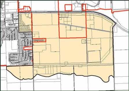
Diverse uses surround the study area. The neighborhood to the west is newer and developed predominately with single-family residences. North of the study area land uses are comprised of large industrial properties including, the vacant Farmland fertilizer plant and the East Hills Business Park. South and east of the study area is the Wakarusa River, the Wakarusa Floodplain and agricultural uses.
Staff Review of Land Use Plan
Two significant issues reoccurred throughout the plan development process: location of an elementary school and the composition of residential neighborhoods; and, the future transportation street network for the surrounding area. Staff along with the CPC concluded that an elementary school was unlikely within the study area. The location and the creation of additional residential land use east of Franklin Road would not meet a minimum threshold for a new elementary school consistent with the planned school model of a three-section school. Travel patterns, the designation of arterial and collector streets, and urban design have been fundamental in assessing land use. The basis of land use is rooted in the adopted Major Thoroughfares Map. During the committee’s review it was noted that the map incorrectly shows an intersection of Franklin Road with the east leg of the SLT. This map error has been corrected. There is no future intersection or interchange with Franklin Road from the SLT. Franklin Road, between 31st Street and 23rd Street, is an arterial street. It is the southern boundary of the north/south arterial street framework that ultimately extends north across the Kansas River and further north to Highway 40. Because of existing land use patterns and existing rights-of-way this arterial street designation is off-set from the northern alignment by approximately one mile (RE: Transportation 2025 maps). Staff’s opinion is that the segment of Franklin Road between 31st Street and 23rd Street will primarily serve the neighborhood and adjacent uses.
Horizon 2020 uses the term “mixed use” to refer to residential and office developments as integral design elements (Commercial chapter policy 3.2). The proposed land uses include only a small area of mixed use along 23rd Street on the east side of the commercial area. The Southeast Area Plan introduces a new land use policy and development concept that has not had public input or discussion as a land use policy. This land use is labeled “employment center”. This use is similar to an industrial/business park type use that is geared toward larger manufacturing/employment center but could include limited commercial or service oriented uses. In staff’s opinion, new policy issues should be amended into the Comprehensive Plan prior to introduction into an area plan. The area plan stage is where refinement of existing land use policies occurs. This land use is undefined and should be addressed first as a policy issue before shown as a specific land use recommendation.
Another concern is the plan’s lack of detail regarding how land use transitions occur for uses located on the east and west sides of Franklin Road. (Horizon 20202 and good land use policy recommend fronting similar uses and backing dissimilar uses.) The use of the arterial street, Franklin Road, as the transition is contrary to policies in Horizon 2020. Horizon 2020 recommends that unlike uses be presented with a back to back relationship.
Residential uses are consistent with Horizon 2020 in location and intent to encourage cluster development with connectivity between individual subdivisions and activity areas such as parks and commercial uses. This element is more detailed in the proposed area plan than in Horizon 2020 as expected. However, streets have often been portrayed as rigid barriers. The alignments within the plan should be viewed as conceptual. Actual street alignments and location of intersections will require detailed survey work and review. Recognition that these alignments are conceptual allows the plan to be dynamic as individual development applications are considered and yet still serve the pattern function for future land use relationships certain elements such as corridor recommendations that are provided through other studies should take precedence such as anticipation of a diamond interchange at Franklin Road and 23rd Street.
Similarly, neighborhood boundaries should not be hard edges. It is reasonable that much of the residential area will be either incorporated into the existing Prairie Park neighborhood or established as something like East Prairie Park. The boundaries of neighborhoods are not always confined by arterial streets as is exampled by the West Lawrence Neighborhood and the Brook Creek Neighborhood. Additionally, neighborhoods can include more than just residential uses such as neighborhood commercial and office uses. To build a neighborhood the full range of mixed use options must be available.
|
|
The area located between 31st Street and the Eastern leg of the South Lawrence Trafficway is one of the more difficult areas to address. The area is relatively narrow in depth and will be located between a highway and an arterial street. The residents within the plan area expressed at a neighborhood meeting with staff their desire to remain residential.
Summary and Conclusion
The land use recommendations in the proposed plan are a result of numerous discussions with the Planning Commission, the Comprehensive Plan Committee and the input of the school district, property owners, and other interested individuals. The plan is based on logical assessments or assumptions primarily that a future elementary school within the study area is not anticipated. Staff concurs with this determination and would not recommend a future elementary school within the study area. In staff’s opinion, specific comments regarding the need for industrial land uses throughout the community both within Lawrence and Douglas County as well as other incorporated cites the total allocation of industrial and employment uses. Trying to capture all the need anticipated in the future for industrial use in on location is excessive and not response to the identified need. A copy of the October outline that was used in the preparation of the Southeast area Plan is included for reference.
South East Area Plan Report outline Option 1: October 2004
1. Assumptions
a. Traffic Assumptions:
i. Traffic assumptions are based on Transportation 2025.
ii. Franklin Road is a Principal Arterial between 23rd Street and 31st Street and extending north of 23rd Street.
1. Franklin Road is identified to be designed in the future with a grade separated interchange at 23rd Street (K-10 Highway).
2. Since the location of Franklin Road is consistent with the one mile spacing between Haskell Avenue and Noria Road it will serve a major traffic function.
3. Franklin Road is identified as a connecting link between 31st Street to K-10 to the north.
4. Franklin Road provides an opportunity to become a connecting link to the future “freeway network”.
iii. Franklin Road is appropriate as the eastern boundary of the adjoining neighborhood.
iv. Gateway applications are appropriate along K-10 to provide an appealing entrance to the community between Noria Road and Franklin Road.
b. Utility Assumptions
i. Utilities can easily be extended to serve the study area
ii. Because of the substantial industrial opportunity it is appropriate to facilitate a joint public/private partnership of the City and County governing bodies to participate in the development of the major infrastructure trunk lines.
c. Neighborhood Assumptions:
i. Residential neighborhood units are defined in Horizon 2020.
ii. Residential neighborhoods are delineated by arterial roads
iii. Residential use is appropriate west of the arterial street (Franklin Road).
1. This marks the boundary of the residential and non-residential area.
2. The residential area west of Franklin Road is part of the overall neighborhood between Haskell Avenue to Franklin Road.
3. Residential use east of Franklin Road is not appropriate. This will minimize “through traffic” in the residential neighborhood.
iv. Residential use is not appropriate east of the arterial street (Franklin Road). It is not large enough to make up an independent neighborhood.
v. The neighborhood lacks a school facility opportunity to the east of O’Connell Road.
vi. Passive and active recreation/open space is appropriate east of O’Connell Road as a buffer/transition to serve all forms of residential uses.
d. Industrial Assumptions:
i. Because of minimal slopes in the study area and soil conditions that do not include rock the area is conducive to industrial development east of Franklin Road and south of 31st Street
ii. Because traffic access and proximity to infrastructure are available or can be extended, industrial uses are appropriate east of Franklin Road and south of 31st Street.
iii. East of Franklin Road is appropriate for a variety of industrial uses along 23rd Street in conformance with existing land use pattern.
1. Conventional heavy industrial uses requiring an open use of land
2. Lighter industrial uses such as “Employment Centers” are appropriate father from 23rd Street and as a transitional use along arterial streets.
e. Commercial Assumptions
i. A single small commercial use to serve employment areas and convenience needs along Noria Road south of 25th Street.
ii. Neighborhood Commercial uses are identified at the intersection of collector/arterial road (O’Connell and 23rd )
iii. Commercial uses shall follow Horizon 2020.
2. Recommendations:
a. Higher density residential uses are appropriate in the planning area specifically as small lot detached and attached housing.
b. Maintain and encourage traffic connections and linkages for major intersections within study area: Franklin Road at 23rd and at 31st Streets; E. 1700 Road at 23rd and 31st Streets; Noria Road at 23rd and 31st Streets.
c. Higher density residential should consist of small lots, attached and detached single-family housing and is not intended for multi-story apartment uses.
d. Community partnership with owners is necessary to acquire and develop property and necessary sewer and water infrastructure.
e. Green spaces are recommended along interior of study area adjacent to highway and freeway network including 23rd, K-10 and 31st Streets.
f. Future industrial uses are not intended to be intensive manufacturing and processing uses requiring large water demands.