Introduction
1.0 Background & Purpose
The development of a Southeast Area Plan began in 1997. The primary issues at that time the were: timing of development (land uses); connectivity of the major street network, the location and timing of the eastern leg of the South Lawrence Trafficway (SLT/K10); and, the timing of city sanitary sewer and water lines to the study area. Meetings were held with the area property owners to gather their input. Planning staff created a draft land use map for the area on August 13, 1997 planning staff presented to the Planning Commission an area plan and a summary of the process followed. The Planning Commission forwarded the Southeast Area Plan to the County Commission for direction on the access points shown in the plan to the SLT/K10. The County Commission deferred a discussion on access due to another; ongoing study of the eastern alignment of the South Lawrence Trafficway (SLT) after this deferral, the Plan was not approved or adopted by any of the three Commissions.
New information regarding traffic routes and specific corridor planning, along with the closing of the Farmland Industries Plant and the update of the City’s Wastewater Master Plan has created renewed interest in developing a master plan for the Southeast Area. The main impetus for revising this plan is a concern for providing the necessary sanitary sewer infrastructure for land uses planned in this area. Development concerns for the area are essentially the same as they were in 1997 - sanitary sewer, major roads, appropriate land uses, and the SLT/K10 alignment. While there has been some additional development in the area, the physical conditions of the study area are substantially unchanged from the conditions that existed in the Southeast Area Plan 1997. The exception is that large areas of land controlled by Farmland Industries have been sold for development.
The recommendations contained within this Area Plan are intended to guide the area’s growth patterns as the development of the Southeast Area occurs. As with any area plan, the intent is that it be consistent with the overall adopted comprehensive plan for the community. It is acknowledged that since more current land use information is available for the study area, the land use portions of the comprehensive plan would need to be updated as well.
1.1 Description of Study area
An area plan’s purpose is to provide a closer look at a specifically described area. The study area’s plan should still fit like a puzzle piece into the larger context of the surrounding street, utility, and land use network of the entire community. Logical connections between the study area and adjacent neighborhoods are a key factor in the development of the plan.
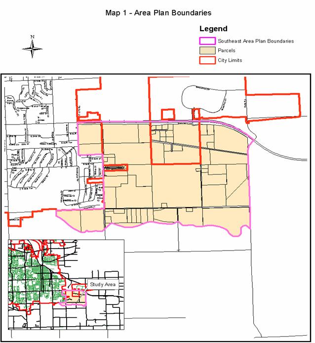
The Southeast Area Plan encompasses all of Section 9, ½ of Section 10 and portions of Sections 15 & 16 in Township 13 S, Range 19 E. The area plan boundaries are E1750 Rd (Noria Rd) to the east; the Wakarusa River floodplain to the south; O’Connell Road (E1600) to the west; and K-10 (E. 23rd Street) to the north. The study area is located completely within the Urban Growth Area (Service Area 1[1]). The majority of the study area lies outside of the city limits of Lawrence. The Southeast Area Plan boundaries are illustrated in Map 1.
Diverse uses surround the study area. The neighborhood to the west is newer and developed predominately with single-family residences. North of the study area land uses are comprised of large industrial properties including, the vacant Farmland fertilizer plant and the East Hills Business Park. South and east of the study area is the Wakarusa River, the Wakarusa Floodplain and agricultural uses.
While the areas described are outside of the plan’s study area, they have significant influence on the land use development patterns within the southeast area. Key influences are the (vacant) Farmland properties and the expansion of East Hills Business Park and the Communities’ need to reserve sufficient wastewater capacity for future industrial uses in these areas.
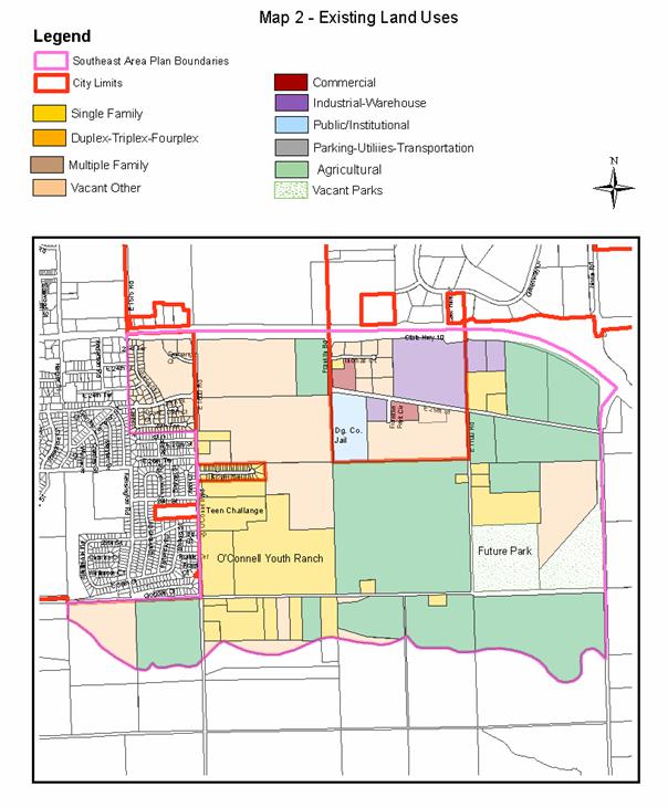
Map 2 illustrates the existing land uses in and around the study area.
The study area is located primarily within the East Lawrence (EL-2) drainage basin. This basin is defined by a ridge line that runs just south of K-10. The basin drains south to the Wakarusa River, away from the City’s existing wastewater treatment plant (WWTP), which is located on the Kansas River. The use of this basin as a factor in the boundary allows for a more cohesive planning effort in the provision of specific utilities such as wastewater and stormwater as the area develops.
The study area contains approximately 1,200 gross acres with a wide range of ownership parcel sizes. Because of the ownership patterns, a coordinated effort on behalf of the property owners is necessary to develop benefit districts to construct the major portions of the required infrastructure. The City’s adopted Development Policy does not include pre-development construction of primary utilities such as sanitary sewer and water.
|
Existing Land Use by Category/Area |
||
|
Residential |
90 acres |
7.5% |
|
Medium Residential |
0 acres |
0% |
|
Commercial |
5 acres |
.4% |
|
Industrial |
165 acres |
13.8% |
|
Public Institutional |
198 acres |
16.5% |
|
Farm/Agricultural |
670 acres |
55.8% |
|
Park/Open Space |
72 acres |
6% |
|
Total |
1200 acres |
100% |
The existing land use summary and map are based on the County Appraisers’ Land Use code as the source data for this portion of the analysis. Much of the existing area is used for agricultural crop production or is woodland /pasture lands and is reflected in the table as “Farm/Agricultural’. A significant portion of the southwest quarter of the area is owned by the O’Connell Youth Ranch and is quasi public/Institutional use. The City has acquired a 39-acre parcel dedicated to future land use. Existing residential and industrial uses are clustered along the existing street network within the study area. There are no existing medium- or high- density residential land uses within the study area because of the lack of supporting water or wastewater infrastructure present to serve that type of land use.
|
|
Section 2 --Existing Conditions
The first step in development of this area plan was the inventory of existing conditions and land uses within the study area. An analysis of those conditions, as they relate to the future development of this study area, was conducted by planning staff in 2002-2003. The inventory and analysis of existing land use conditions in this plan is intended to serve as a resource and background for the recommendations included at the end of this plan.
2.0 Existing Land Uses
There is a wide range of land uses within the study area. Agricultural use, in the form of row crops and pasturelands, are the prominent land use within the study area. As the area is urbanized, this agricultural use will dissolve and be reused for more intensive land use types. This category is not carried forward to the future land use map. Remaining open spaces in an urbanized environment are referred to as “Green Space” or “Future Park”.
The second largest land use category is public and privately owned Public/Institutional uses. Publicly owned uses are the Douglas County Correctional Facility located at the southeast corner of Franklin Road and E 25th Street and the future City Park site located at the northeast corner of E 1700 Rd and 31st Street extended. Private Institutional uses include the O’Connell Youth Ranch and Teen Challenge facility (private use) located at the northeast corner of O’Connell Road and 31st Street Extended. The City’s future Park site is currently undeveloped. Because of the residential element of O’Connell Youth Ranch, the property was mapped as residential.
The remaining land is designated for industrial or single-family residential uses. The industrial areas are characterized by uses that require open use of land where activity is not conducted within the confines of a building or structure. These uses are clustered along K-10 Highway and at the northwest corner of E 1750 Rd and N 1300 Rd (31st Street extended).
2.1 Existing Zoning Patterns
The majority of the study area is within the unincorporated portions of Douglas County and is zoned (A) Agricultural. Additional County Zoning Districts within the study area occur predominately along K-10 Highway and include: B-1 (Neighborhood Business District), I-1 (Limited Industrial District), and I-2 (Light Industrial District).
There are a number of city zoning districts within the study area. Planned Residential Development (PRD-1) zoning is located along E. 27th Terrace, on the east side of O’Connell Road (E1600). This area is developed with low-density residential structures in the form of duplexes and is reflected on the maps as “Low-Density Residential”. Planned Industrial Development (PID-2) zoning is located along K-10 Highway and E. 25th Street. A portion of this PID area remains undeveloped. The developed area includes: concrete and asphalt plants, the Douglas County Correctional facility, a self-storage business and a wrecker company. These uses are representative of the area shown as existing industrial land use within the study area, the exception being the public institutional use of the correctional facility.
Recently the 54 acres located southwest of the corner of K-10 Highway and O’Connell Road (E1600) was annexed into the city and rezoned to O-1 (Office District), PRD-2 (Planned Residential District), and RS-2 (Single-Family Residence District). These rezonings generally relate to the development intensity, density, and land uses recommendations of this plan for the area along the east side of O’Connell road.
|
|
2.2 Existing Utilities and Infrastructure
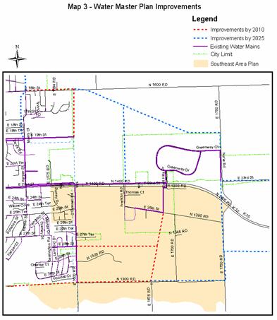
A summary of the existing water and wastewater utilities and the street network is provided in this section. Maps 3 and 4 illustrate the existing water and sanitary sewer service for the study area.
A water line was recently installed along O’Connell Road as part of the street improvements in anticipation of future development. Municipal water is provided to those properties that are within the current city limits. Extending the public water supply in this area is the least complex of required municipal services.
|
|
2.21 Water and Wastewater Infrastructure:
In keeping with the city’s adopted Development Policy of not providing municipal utility services to properties outside the city limits, Lawrence’s sanitary sewer and water lines have not been extended beyond the city limits. Properties that are within the study area but outside the city are served by non-municipal water (well, pond or hauled) and septic tanks.
The provision of sanitary sewers for the study area and the surrounding properties is achieved primarily through gravity lines that collect the effluent and transmit it to pump lift stations. These lift stations re-elevate the effluent to a height where it can gravity flow to the city’s WWTP on 8th Street. Development of property within the study area to urban densities requires annexation before the extension of municipal utilities, both water and wastewater, to serve this area.
Significant existing industrial developments are related to the study area. The Franklin Park area located on the south side of K-10 includes the County Jail facility. East Hills Business Park is located on the north side of K-10 which is outside of the boundary of the study area. Both existing industrial areas are developing and still include vacant parcels within. The Farmland Property immediately west of East Hills is also a land use that is anticipated to contribute to wastewater demands in this area in the future.
A small, 10-acre residential development is located within the study area and is currently provided with municipal services. That development deviated from the City’s Wastewater Master Plan. It includes a lift station that directs effluent back to the west. A second phase to this residential development was denied because it would require continued digression from the City’s adopted Wastewater Master Plan. The existing lift station would ultimately be retired when a more appropriate system is constructed in this area.
|
|
|
2.22 Streets Infrastructure:
Currently, the only roads in the study area that are constructed to city standards are Franklin Road, Franklin Park Circle and a portion of E. 25th Street. O’Connell Road (E1600 Rd) is considered a “boundary line road” because of its location coincident with the city limits. Reconstruction of O’Connell Road (E1600 Rd) is currently under way as part of a joint City/KDOT project. The major street element of the Southeast Area Plan is the arterial and collector street network.
Arterial Streets- Arterial Streets within the Southeast Area include E. 23rd Street on the north and 31st Street (N 1300 Road) extended on the south and Noria Road (E 1750 Road) at the far eastern end of the study area. Franklin Road (E 1700 Road), north of 31st Street, is also a designated north/south arterial street in the center of the study area. Franklin Road and Noria Road serve as the only designated north/south arterial streets within the study area. Both streets are proposed to extend to the north of 23rd Street. The other major street element is the South Lawrence Trafficway/K-10 Highway connecting link, which is the general south and east boundaries of the study area. The study area is comprised of larger tracts and relatively few rural township/local streets at this time. As the area is urbanized the local street network will expand, with other public infrastructure, to serve developing uses.
Collector Streets - The existing collector street will be the key framework to the development land use as the area is developed. Designated north/south collector streets are O’Connell Road on the western edge of the study area and 1700 Road about one mile east of O’Connell Road. Designated east/west collector streets include 25th Street and 27th Street. These streets together provide the framework to frame the projected land uses within the study area. The existing streets provide a connection to the overall City and County street network and are reflected as a whole on the adopted Transportation 2025 Major Thoroughfares Map.
|
|

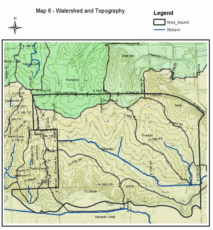
2.3 Environmental Conditions
The study area is in the East Lawrence (EL-2) drainage basin, which is south of the Kansas River (KR-6) drainage basin. The east-west ridge line that separates the two drainage basins generally runs along K-10. The basin north of K-10 (KR-6) drains to the north toward the Kansas River valley. The basin south of K-10 (EL-2) drains to the south toward the Wakarusa River valley. There is no Federal Emergency Management Agency (FEMA) designated floodplain located within the study area. The southern boundary of the study area is the Wakarusa River floodplain as designated by FEMA.
There is a minimal amount of woodland areas within the study area. The majority of the undeveloped land within the study area is used for either row crop or pasture land. Existing tree cover is found at two high points in the northeast and southwest corners of the study area. The majority of slopes within the study area are in the 0-3 percent range as identified in the Soil Survey of Douglas County, Kansas. Some areas of 3-7 percent slope can be found in the northeast and southwest corners of the study area. There is a significant drainage way that has more recently been mapped that bisects the study area on an angle from O’Connell Road back toward the southeast.
As described earlier the study area is comprised of substantial agricultural pastureland uses. Woodland cover exists in two areas of the study area, the northeast at K-10 and Noria Road and North of 31st Street east of O’Connell.
A lack of steep slopes is considered to a beneficial factor for urban development. Detailed topographic surveys will be required as individual properties are developed. Map 6 illustrates the existing environmental features of the study area.
|
|
2.4 Public Services/Facilities
The study area lies to the south and east of the City of Lawrence. Consequently, all public services (schools, fire/medical, police, parks, etc.) are to the west and north of the subject property. The subject property is relatively close to a number of public facilities and will be served by existing public facilities. A significant issue discussion has focused on is the ability of the existing Prairie Park Elementary School to accommodate additional students that would be generated from new residential development in the study area.
The City has purchased approximately 40 acres within the study area for a future park. There has been discussion that a portion of the city property could be developed for a school facility if necessary. Need for a new elementary school is determined by the school board based on residential population projections. From the projected land use, it is unlikely that a sufficient number of children will be generated from the residential area to justify development of a new elementary school. Elementary schools are encouraged to be integral to developing neighborhoods as applicable. Based on discussions with USD 497 staff and officials there is no expectation that a future elementary school will be developed within this study area. The typical format for elementary schools is a three-section building. Ultimately school boundaries will need to be reevaluated through the life cycle of existing and future neighborhoods. Therefore, there is no expectation that has become a basic assumption in the preparation of this study.
Public or Institutional land uses shown on the land use map as existing land uses are anticipated to be redeveloped in the future as the area urbanizes. These areas include: O’Connell Youth Ranch and Teen Challenge as well as the City Property. The County Jail site was developed with expansion in mind and will remain a public facility within the study area.
The study area will be served partially by Fire/Medical Station Number 2, an existing facility located on Harper Street north of 23rd Street. A future station location has conceptually been identified by Fire and Medical staff as being necessary east of the City Park property to serve the larger southeast extent of the recently expanded urban growth area. A more detailed and in depth study will need to be conducted to ultimately locate the facility and to address timing issues as this portion of the community develops. There is not an identified priority for the development of the future fire stations other than very general location.
2.5 Urban Growth Area Designation (UGA)/
Existing Future Land Use [Per Horizon 2020]
The land use plan in Horizon 2020 is the foundation document used to develop specific recommendations for the Southeast Area Plan. Land use density descriptions are reiterated in this document and refined, but are not intended to alter or otherwise revise what is found in Horizon 2020. The following is a brief summary of the future land uses for this area as they are currently established in the comprehensive plan.
Horizon 2020 and the Southeast Area Plan:
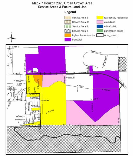
- The Southeast Area Plan is located in the recently expanded UGA.
- The Southeast Area Plan is located predominantly in Service Area 1 with only the area south of 31st Street (N 1300 Road) extended being located in Service Area 4.
- Land uses recommended in Horizon 2020 for the Southeast Area include:
- Higher density Residential (west side of O’Connell Road only)
- Low-Density Residential (both east and west sides of O’Connell Road)
- Industrial (surrounding existing industrial areas, and along existing and future highways)
- Mixed Use (along south side of K-10, and along North side of 31st Street extended and along SLT alignment)
Horizon 2020 identifies the study area as being within the City of Lawrence Urban Growth Area (UGA). A majority of the study area is identified as being located within Service Area 1. Designated land uses were applied to all areas within Service Area 1 as shown on Map 3-1 “Lawrence Urban Growth Area Service Areas and Future Land Use” found in Horizon 2020. Service Area 1 is generally considered to be the area that will urbanize first as urban services are readily available or extendable to it. A small portion of the study area is located within Service Area 4 and makes up that area south of 31st street extended otherwise know as N. 1300 Road.
Horizon 2020 identifies that urbanization of Service Area 4 should occur only after a municipal wastewater treatment system (to serve the area) is either planned or under development. The recently approved update to the City’s Wastewater Master Plan for the City of Lawrence indicates that sanitary sewer can be provided to the study area. How service will be provided is based on a more in-depth study that recommends that sewer lines for the effluent from the study area be designed for ultimate treatment at the proposed Wakarusa River WWTP when the plant becomes operational.
Land use designations come from Figure 9 - Lawrence Urban Growth Area, Service Areas, and Future Land Use and Figure 9 Inset - Lawrence Future Land Use found in the current comprehensive plan, Horizon 2020.
Horizon 2020 identifies only four land use categories that are appropriate for the study area; Industrial, Mixed Use, Low Density Residential, and Higher Density Residential. The Higher-Density Residential is the least predominate land use recommended by Horizon 2020. The comprehensive plan recommends that this land use be located at the southwest corner of K-10 and O’Connell Road (E1600 Rd). A recent development application for 55 acres on the west side of O’Connell Road included an area for multi-family residential development in this general location. This specific 55-acre parcel, known as Fairfield Farms West, is discussed later in this report as part of the future land use section of this area plan.
Additional land uses recommended by the comprehensive plan include: Low-Density Residential, Industrial, and Mixed-Use. Horizon 2020 defines Low-Density Residential development as having an overall density of 6 or fewer dwelling units per acre. Low-Density Residential development is expected to continue as the “predominate land use in the city” as stated in Horizon 2020.
Horizon 2020 recommended industrial uses for the area surrounding the existing industrial uses along the south side of K-10. The current industrial area extends east to Noria Road between E. 23rd Street and 25th Street extended. Additional industrial area includes area between E. 1700 Road south of 25th Street to Noria Road and an area that follows existing drainage way on the west side of E 1700 Road and the current boundary of the KDOT right-of-way to the east forming a “V” shape. The remaining area east of Franklin Road north of 31st Street to Noria Road is currently described as “mixed use” in Horizon 2020.
The fourth land use recommended for the study area by Horizon 2020 is “Mixed-Use”. This is an undefined term in Horizon 2020. A general planning use of the term implies a combination of two or more different categories of land uses, such as residential and commercial, or industrial, commercial and office. Horizon 2020 identified mixed use locations along K-10 between O’Connell Road (E1600 Rd) and Franklin Road, and north of N 1300 Road between Franklin Road (extended) and E 1750 Road.
Specific land use recommendations resulting from this area plan will require amendments to Horizon 2020 for consistency. The Land use chapter and maps will be most affected by these changes. The development policies and densities are not intended to be altered in any way. Specific map changes to Horizon 2020 will also be required.
|
|
Section 3 -- Envisioned Future
This section of the plan is a summary of the existing master plans and improvement projects of the city, specifically as they relate to the southeast study area and the future development of that area. This summary of future visions and improvements is provided as a guide and foundation for the recommendations outlined in this area plan.
- Horizon 2020. The Comprehensive Plan for the City of Lawrence and Unincorporated Douglas County.
- Transportation 2025. The comprehensive transportation plan for the City of Lawrence and Unincorporated Douglas County.
- 23rd Street Corridor Study
- 31st Street Corridor Study
- Water Master Plan
- Wastewater Master Plan
3.1 Horizon 2020
Horizon 2020 is the long-range comprehensive plan for unincorporated Douglas County and the City of Lawrence. It provides policy recommendations for future land uses and development through the year 2020. This plan was developed during the mid-1990s, utilizing a community-wide public participation process that allowed community residents to envision how they would like the community to develop in the future. This section of the Southeast Area Plan summarizes the goals and policies in Horizon 2020, as they specifically relate to development of the Southeast Area.
Relevant goal statements from Horizon 2020 providing support for recommendations in this plan will help guide future development of the study area so it is consistent with the intent of the city’s long-range plans for future growth and development. Specific Goals and Polices from Horizon 2020 are reiterated in this proposed plan and can be found in the appendix.
3.11 Residential Density
Horizon 2020 establishes residential densities for low, medium and high density development. The Southeast area plan does not seek to alter these density ranges. The Southeast Area Plan establishes general locations for low-density residential and medium density residential development. The plan does not include a recommendation for very high residential density. Residential uses are recommended between O’Connell Road and Franklin Road. Franklin Road is the boundary line between residential and non-residential uses within the study area.
Low-Density Residential Development
Low-density residential development, reflecting a density of six or fewer dwelling units per acre, would continue to be the predominant land use in the city. While this classification includes densities that would encompass duplex and some townhome housing, emphasis is placed on single-family detached development.
For the purposes of this plan low-density residential land use is only recommended in the western portion of the development between 25th and 31st streets.
Medium-Density Residential Development
Medium-density residential development, reflecting an overall density of 7 to 15 dwelling units per acre, is recommended as clustered development at selected locations along major roadways, near high-intensity activity areas, and when adjacent to important natural amenities. This type of land use may be a likely choice for cluster development where density can be transferred from the natural area to the remainder of the property to creatively retain natural features which will enhance the overall development.
The Southeast Area Plan specifically identifies mixed use and medium density residential uses along the west side of Franklin Road between E. 23rd Street and 31st Street. Medium-density residential uses are expanded to include duplex and triplex housing on smaller lots or in cluster development. The plan is not intended to include a significant portion of multi-story, multi-building conventional apartment development.
3.12 Non-Residential Land Uses
The balance of the Southeast Area will include a range of non-residential uses including commercial, industrial, public facilities and open space uses. The commercial land uses recommended for the Southeast Area are specifically identified in Horizon 2020, Chapter 6. Key in this chapter is the concept of nodal development and that importance is reflected in this area plan.
Commercial
The Goals and Strategies in Horizon 2020 center on the Nodal Development Concept for new commercial development and the definitions of the four different categories of commercial nodes: Neighborhood, CC200, CC400, and Regional Commercial. Two new neighborhoods commercial areas were identified in Horizon 2020 one is recommend at E. 23rd Street and O’Connell Road and the other is at Franklin Road and N 1300 Road (31st Street extended). The Southeast Area Plan was developed with these two concepts as “givens” but includes an alternative location recommendation for the Franklin Road and 31st Street location as a result of transportation and other land use considerations.
Horizon 2020 recommends new neighborhood commercial areas be developed as small, compact commercial nodes that provide goods and services to the immediately adjoining neighborhood areas. They shall be developed in a manner that is consistent with the goals, policies and recommendations of the Comprehensive Plan.
Industrial
Industrial and employment center uses make up a majority of the land use within the study area. This use was expanded as a result of numerous discussions with staff, Chamber of Commerce, ECO2, and other interested individuals. The plan recognizes the existence of existing industrial land uses along E. 23rd Street, and the streets network including arterial and highway connections within the area. The plan does not recommend or encourage heavy industrial user that have a substantial processing element or result in emissions type activity. Industrial uses are generally of a low intensity or manufacturing type that requires land for material assembly, staging, equipment storage, warehouse and similar uses.
The plan recommends a new land use category “Employment Center Use”. An employment center is similar to office park type complexes that accommodate larger vehicles, delivery and warehouse operations, and have a significant employment base. This use extends from Franklin Road to Noria Road and from 25th Street to 31st Street. The area south of 31st Street is also designated for employment center uses since this area is bounded by the South Lawrence Trafficway on the south and 31st Street on the north.
Public facilities and open spaces
This land use is reflective of the existing County Jail Facility located on the southeast corner of Franklin Road and 25th Street. New public facilities are not anticipated or planned within the study area at this time. Police, Fire, and Emergency Services are provided nearby and provide service or can be expanded to provide services to the study area as it is annexed and developed.
School facilities are a significant component of area planning but are not recommended to expand within the study area. The population needed to justify a new elementary school in this area was not determined to be feasible based on the recommended area for new residential growth. The past practice of USD 497 has been to develop three-section schools and this is expected to continue into the future. The City and the School District have collaborated in the development of combined school/park sites for many years now. This collaboration effort is expected to continue.
The City of Lawrence owns a 40-acre property located on the northeast corner of E. 1700 Road and 31st Street. This property is currently designated as a future park site. Undesignated open spaces are conceptually identified as major drainageways within the study area and along the major streets including E. 23rd Street, Noria Road and 31st Streets. These open spaces will provide transition space for buffering, and recreational links within the study area to other facilities within and surrounding the study area such as bike routes and park sites.
Specific changes to Horizon 2020 will be required to correlate this plan within the Comprehensive Plan but are predominantly map changes.
3.2 Transportation 2025
Transportation 2025 (T2025) is the long-range transportation plan for the urbanized region that includes the City of Lawrence and the surrounding areas of the County that area expected to become urbanized through 2025. T2025 established a number of general goals and policies that would apply to the SE Area Plan. Some specific recommendations made by T2025 for the study area are the completion of 31st Street from Louisiana Street to Noria Road and upgrading Noria Road from E. 23rd Street (Highway K10) to E. 31st Street.
T2025 states that “the 31st Street corridor from Louisiana Street to Noria Road is recommended for completion and widening to four lanes.” The Major Thoroughfares Map in both T2025 and Horizon 2020 indicate 31st Street (N 1300 Rd) will be a principal arterial extending from Kasold Drive on the west side of the city to E 1900 Rd (County Route 1057), which is east of the current city limits. The eastern extension of 31st Street passes through the southern portion of the study area. When the ultimate improvements to 31st Street are complete, the study area will have access to east-west principal arterial streets along its north (E. 23rd Street) and south (E. 31st Street) boundaries. Both of these corridors have been the subject of recent and on-going studies and planning efforts locally and at the state level. It is important to note that some initial work has been completed on the plans for extending 31st Street. There are no immediate plans to begin construction/reconstruction of either of these streets.
The Major Thoroughfares Map shows both arterial and collector streets that serve the study area. Many of the streets shown on this map require either improvement to the existing road or dedication of public right-of-way for construction of a new road. The study area is a portion of the overall street network. Collector and arterial streets within the study area feed back into the overall network serving the community at large. This study does not seek to alter the approved Major Thoroughfares Map in any way.
The eastern leg of the SLT/K10 will have a major influence on both development patterns and the street network of the study area. The proposed eastern leg of the SLT/K10 is anticipated to pass through the extreme southern and southeastern portions of the study area. The most recent revisions to the eastern leg of the South Lawrence Trafficway does not include direct access from any street within the study area. Franklin Road will serve the study area and provide connectivity to the overall major street network as a city arterial street with a diamond interchange at K-10 Highway (E. 23rd Street) that extends across the Kansas River and connects with US Highway 24/40.
In addition to the proposed collector and arterial streets for the study area, there are number of proposed bike routes that are designated to serve the study area. Bike routes follow the arterial and collector streets and the SLT/K10/K10. Bike routes are typically installed at the time of road construction and or development of the adjacent property.
3.3 Water Master Plan/Infrastructure Improvements
Fundamental to development, Horizon 2020 recommends that development be timed with minimum infrastructure improvements. Key among these are water, wastewater and street facilities.
Maps 3 and 4 illustrate the city’s planned water infrastructure improvements for the study area as shown in the Water Master Plan. The study area can be served by city water as infrastructure improvements are put into place. An important component of providing the proposed improvements is the need for redundancy and the “looping” of water lines to provide a reliable water source.
The City’s Water Master Plan establishes two target dates for future extensions. Initial improvements by the year 2010 would be extending service to the east along 31st Street and 27th Street. An additional north/south connection would be made between E 1675 Road at the south end to 25th Street at the north end. A second phase of water line extension include along 31st from E. 1675 road to Noria Road and along Noria road between 31st Street and E. 23rd Street/K-10 Highway. Additional extensions extend beyond the study area to the east and north as the area develops.
Water lines are installed per the City’s development policy at the time of development along the public street frontage. Installation of water lines is dependant on development of individual properties. The City’s capacity to provide water is deemed adequate to serve the needs of the city over the planning period as stated in Chapter 10 of Horizon 2020. The system can be expanded to undeveloped portions of the UGA in the future. This study does not seek to alter the recommended policies found in Horizon 2020 regarding the need to annex prior to extension of services.
3.4 Wastewater Master Plan/Sanitary Sewer Infrastructure Improvements
Horizon 2020 recommends provision of adequate public improvements as this area develops. The planning of the sanitary sewer infrastructure improvements necessary to serve the study area is one of the critical components for the development in the southeast area. When the Wastewater Master Plan was first adopted in 1995, staff provided the city’s consulting engineering firm, Black and Veatch (B&V), with population projections for this study area. As interests have increased in development of the study area, planning staff and City Utility Department staff has worked with one of the study area’s primary developers to conduct an in-depth study of the area’s population projections. In re-studying potential land uses and developing revised population projections, it became apparent that the original projections underestimated the study area’s potential development. Planning and Utilities staff have been working closely with B&V to provide background data for the 2004 Wastewater Master Plan update, which projects the infrastructure improvements necessary to serve the potential development in the study area.
The initial population projection for the study area was approximately 2,900 persons. That projection was reevaluated by planning staff, the City Utility Department, and area developers to reflect potential development for the area. Based on this closer examination and more detailed development information, the city has revised the area’s population projection to approximately 6,500 persons. The 2004 update to the Wastewater Master Plan for the southeast area is based on this projected population of 6,500 persons. The 2004 revised population projections were based on approximately 470 acres being low- to medium- density residential uses.
The Comprehensive Plan Committee (CPC) is a Planning Commission sub-committee with the task of reviewing area plans. The study area population projection was based upon the draft Southeast Area Land Use plan that included low and medium density residential uses east of Franklin Road. The revised population projections were then used to create the short- and long-term wastewater plans for the study area. Two draft land use alternatives were provided to the Planning Commission as a whole for consideration in October 2004. Each option included a range of uses. The option directed by the Planning Commission to consider includes a significant industrial element. The wastewater projects have not been updated to reflect this land use. Industrial uses tend to have a diverse range of impact on water and wastewater demands depending on the intensity of processing associated with the use.
Revised assumptions about land use and corresponding demand for wastewater treatment will require a specific and detailed analysis that is not available at this time. Future land uses can be thought to result in an equivalent of residential population and may result in additional timing considerations for future development.
Like the water master plan a phased approach for wastewater service was developed. Whether this phase will function with the proposed land uses must be additionally evaluated.
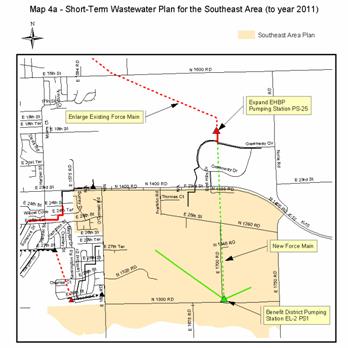
3.41 Short-Term Wastewater Plan for the Southeast Area (to year 2011)
The 1995 WWMP identified “short-term” recommendations for the southeast area. These recommendations include the construction of a gravity main connecting to a pump station (EL-2 PS1) located at the intersection of E 1700 Rd and N 1300 Rd. The effluent is then pumped by a force main under Highway K10 to the East Hills Business Park pump station (PS-25). These public improvements are proposed to be financed through the creation of an anticipated County sewer benefit district. Part of these “short-term” recommendations also include enlargement of the East Hills Business Park pump station and the force main from that station to the Kansas WWTP. Those improvements are to be funded by the city-at-large.
Part of a larger community planning and economic development issue is the need to manage the intensity of growth in the Southeast Area to “reserve” sewer rights for potential industrial redevelopment of the former Farmland Industrial site or expansion of existing businesses in the East Hills Business Park. This policy issue is still under review by the City and County Commissions.
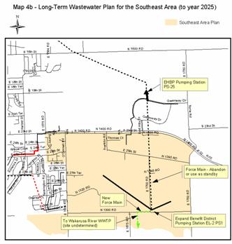
3.42 Long-Term Recommendations of Improvements for the Southeast Area (to year 2025)
The long-term wastewater improvement recommendations for the study area were created by B&V with input from the City Utility Department and the Planning Department. These recommendations were created to accommodate anticipated ultimate development capacity of the study area. The key component of the long-term plan is construction of the Wakarusa River WWTP, which is anticipated to occur around 2011. After the Wakarusa River WWTP is constructed, pump station EL-2 PS1 (which serves the study area) is recommended to be enlarged and pump its effluent to the south to the Wakarusa River WWTP via a new force main. Capacity at the enlarged East Hills Business Park lift station will be relieved by the new treatment plant, freeing it up to serve any remaining industrial development that occurs north of K-10. The force main between EL-2 PS1 pump and the East Hills Business Park pump will either be removed or used as standby main. These recommendations are not anticipated to change with the proposed land use recommendations of this study.
3.5 Potential and Approved Development Projects
This study was initiated as a result of two developer’s proposals for property within the study area. These proposals are for the northwest and southeast quarters of Section 9-13-19. One request includes a large portion of the area between O’Connell Road and Franklin Road, and the other includes property owned by the Kitsmillers’ between Franklin Road and Noria Road (E1750). The Kitsmillers’ project was formally withdrawn by the applicant following the Planning Commission’s recommendation to pursue plans for the area that include a limited amount of residential uses within the study area. The rezoning requests for the east side of O’Connell Road (E1600) included Commercial (C-5) at the southeast corner of E. 23rd Street and O’Connell Road (E1600); Research Industrial (M-1) and Multi-Family Residence (RM-1) east of the commercial area; Duplex-Residence (RM-D) to the south of the commercial and industrial area; and Single-Family Residence further to the south. The rezoning applications have been deferred from public hearing and consideration by the Planning Commission until the Southeast Area Plan could be adopted. A 55-acre development, known as Fairfield Farms, on the west side of O’Connell Road was approved and has since been annexed, rezoned and platted for a mix of residential uses and densities.
|
|
Section 4 -- Recommendation
The Southeast Area is anticipated to develop as an area that has a wide range of uses and intensities that extend from low-density residential to heavy industrial uses. The more intensive industrial and commercial use areas are recommended where they are in close proximity to E. 23rd Street/K-10 Highway. A small neighborhood commercial area is recommended to serve the industrial and employment center at the corner of 27th Street and E. 1700 Road. Additional industrial uses are anticipated to occur between E. 31st Street and the eastern leg of the South Lawrence Traffic Way. Key elements in this plan are the assumption that no new elementary school will be constructed within the study area; industrial uses are maintained and expanded from the recommendations found in Horizon 2020 to best take advantage of the future highway connections that are anticipated for the area. The remaining residential areas will be incorporated into the Prairie Park Neighborhood to the west of the study area.
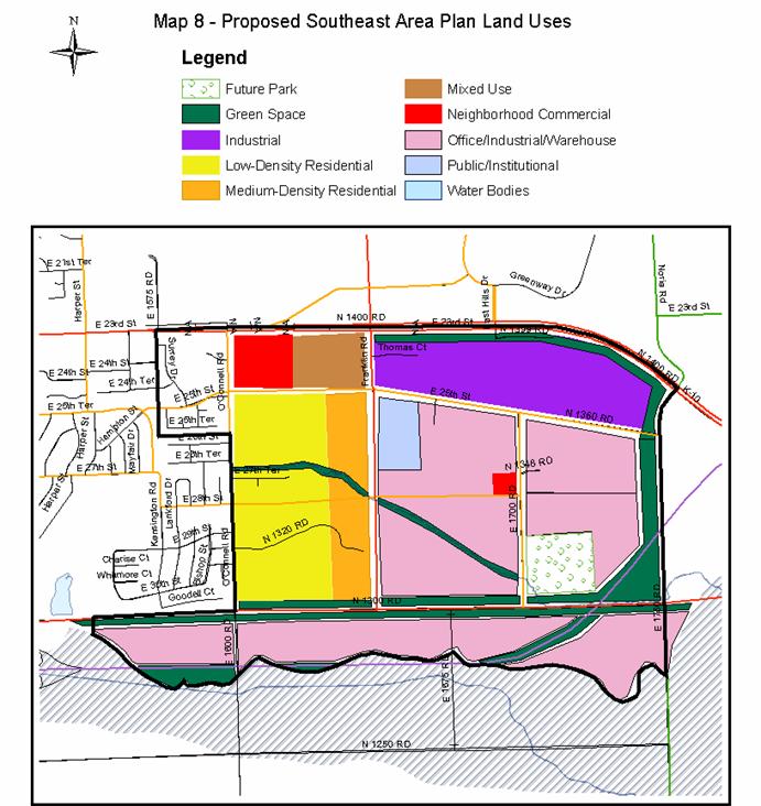
Map 8 provides a general concept for the location of recommended land uses in the Southeast Area. It is not intended to provide a scaleable map for determining specific land use/zoning boundaries within this area.
|
Land Use by Category/Area |
||
|
|
Existing Land Use Distribution |
Proposed Land Use Distribution
|
|
Single Family Residential |
90 acres |
112 acres |
|
Medium Density Residential |
0 acres |
143 acres |
|
Commercial |
5 acres |
45 acres |
|
Industrial |
165 acres |
681 acres |
|
Public Institutional |
198 acres |
22 acres |
|
Farm/Agricultural Less Fairfield Farms |
670 acres 619 acres |
0 acres |
|
Park/Open Space |
71 acres |
71 acres |
|
Total Less Fairfield Farms |
1128 acres 1074 acres |
1074 acres |
4.1 Low-Density Residential
Only that area in the extreme western portion of the study area between 25th and 31st street is recommended for low-density residential development. Streets should be extended and connected in a grid type pattern for the area. Pedestrian connections shall be given a priority in design and be integral to development connecting individual subdivisions with open space areas, planned recreation paths, and commercial centers.
The low density residential use extends to the north side of 31st Street (a designated arterial street). Special attention will need to be paid as local streets are developed to minimize impact of the traffic to the abutting residential use and limit and avoid to the greatest extent possible the intersection of a local street with an arterial street. A short length of a residential collector street between 27th Street and 31st street may be necessary to provide residential access to the low-density area.
4.11 Medium-Density Residential
The remaining residential uses that are recommended in this Plan are for Medium Density Residential uses. Horizon 2020 defines medium-density residential to be a “density of 7 to 15 dwelling units per acre”. The medium-density residential uses are located in transition areas that serve to buffer the less intensive low-density residential uses from more industrial and/or commercial uses to the east. Medium-density residential development shall take the form of small lot, detached, attached or cluster type housing and is not intended to provide for large scale conventional apartment development for the entire area designated for medium density.
A primary consideration of the medium density and smaller lot development is the encouragement of housing that is considered to be affordable. Affordability is intended to be directed to first time home buyers in a range of housing options for owner/occupancy. This recommendation is separate from other existing municipal programs addressing low-income housing.
Apartment uses may be considered for that area west of Franklin Road between E. 23rd Street and 25th Street. However it is intended as a mixed use combining office, limited commercial and residential elements. An example of this would be office/service uses at the ground level with apartment uses on the successive levels.
· Residential uses shall maintain a back to back relationship of unlike uses. Buffering shall include use of green space as a primary transition tool.
· Residential streets shall be extended to undeveloped property and shall use a grid or modified grid pattern.
· Medium-density residential development shall take the form of small lot, detached, attached or cluster type housing.
· Medium-density is not intended to provide for large scale conventional apartment development
4.2 Commercial
The Commercial Land Use chapter of Horizon 2020 recommends two Neighborhood Commercial Centers be located within the study area. Horizon 2020 does not identify a specific corner for where the commercial uses should be located. However, this plan, acting as a supplement to Horizon 2020, provides a more detailed recommendation regarding the Commercial use locations. The larger Neighborhood Commercial Center is recommended at the intersection of O’Connell Road (E1600) and E. 23rd/K-10 Highway. Pedestrian connections shall be given a priority in design and be integral to development connecting commercial centers with open space areas, planned recreation paths, and residential areas.
4.21 Neighborhood Commercial Center at O’Connell Road
By definition “A Neighborhood Commercial Center provides for the sale of goods and services at the neighborhood level”. (Horizon 2020, Pg 6-4) This Neighborhood Center will serve a general area that is bounded by E. 23rd Street, Harper Street, E. 31st Street, and Noria Road. It will capture both existing development and future development. The majority of the residential neighborhood population will be located west of Franklin Road. Moving the Neighborhood Commercial Center further to the east takes the Center further away from the neighborhood population it is intended to serve. This location is consistent with the most recently approved commercial recommendations in Horizon 2020’s Chapter Six - Commercial Land Use adopted in March 2004.
Placing the Neighborhood Commercial Center further to the east would create several significant land use & traffic problems. The first is a line-of-sight issue. Without significant re-grading of the E. 23rd/K-10 Road alignment, visibility for west-bound motorists of any commercial development on the southwest corner of the highway’s intersection with Franklin Road would be significantly impaired. Limited sight distance also has the potential to create traffic safety issues for west-bound motorist as they try to negotiate lane change, while decelerating speed and crossing the eastbound lanes of E. 23rd Street/K-10 Highway to reach the commercial area.
4.22 Neighborhood Commercial Center at 1700 Road
A smaller Neighborhood Commercial Center is identified in Horizon 2020 at the intersection of Franklin Road and E. 31st Street. This plan recommends the second smaller neighborhood center be located at the intersection of 27th Street and 1700 Road as a focal point and convenience center for the Employment Center and Industrial uses in that part of the study area. This will require an amendment to Horizon 2020.
Because of its proximity to the Neighborhood Commercial Center at O’Connell Road and E. 23rd Street/ K-10 Highway, this plan recommends that the Commercial Center located at 27th Street and E. 1700 Road be smaller than a typical Neighborhood Commercial Center. This plan recommends that this Neighborhood Commercial Center be no larger than 10 acres and with no more than 15,000 gross square feet of commercial space. 15,000 gross square feet should be adequate for a convenience store and a couple of retail service stores.
· The main Neighborhood Commercial center shall be designed in accordance with polices and standards of Horizon 2020
· The second Neighborhood Commercial Center shall be no larger than 10 acres and with no more than 15,000 gross square feet of commercial space
· Commercial development shall be designed to facilitate pedestrian and non motorized access from abutting residential areas.
4.3 Industrial & Office/Industrial/Warehouse
Industrial land uses are to be located toward high intensity areas that are located along existing (K-10) and future (SLT/K10 and E. 31st Street) arterial and expressway routes. The Industrial land use category is a more intensive use category than the Employment Center (old definition -- Office/Industrial/Warehouse) land use classification. Industrial land uses are typically those that have a high amount of truck traffic, a large amount of material processing that occurs outdoors, use hazardous substances, or generate high levels of noise, dust, or light. Employment Center (old definition -- Office/Industrial/Warehouse) land uses are uses that typically occur inside factory walls, have a smaller amount of truck traffic, and do not generate high levels of noise, dust, or light. These uses are typically warehouse or office uses. This plan seeks to encourage individual businesses that generate employment that can take advantage of the easy access to the area.
The areas proposed for Industrial land uses are those areas that are already occupied by or in the vicinity of existing heavy industrial uses. This plan recommends that additional areas appropriate for Industrial land use are along E. 23rd Street, between Franklin Road and Noria Road. The boundary between the industrial land use and the less intensive employment areas is 25th Street.
The Employment Center (old definition -- Office/Industrial/Warehouse) uses are recommended for a majority of the study area between 31st Street and the South Lawrence Trafficway and for that area between Franklin Road and Noria Road. Both E. 31st Street and the SLT/K10 will generate high amounts of traffic. Placing these uses between these two roads will provide potential Employment Center uses with access to a major arterial. Employment Center uses are considered to be compatible with the high level of noise and light that are anticipated to be generated by traffic along E. 31st Street and the SLT/K10. These uses would not rely on drive by traffic or visibility from streets.
The ability to encourage and facilitate these uses is the requirement for adequate public facilities in the form of water and wastewater utility extensions. A related element is the need to provide a mechanism for holding industrial land for the time it takes to be developed. This will require significant and coordinated efforts on the public part to execute this part of the plan.
· Employment center uses are recommended for a large portion of the study area
· Development of an implementation/capital improvement program to extend water and wastewater infrastructure to serve the area.
· Development of a program (modeled on the East Hills Business Park) to acquire and market land for industrial and employment center uses.
4.4 Public Facility/Open Space
The three major land uses related to public facilities for the study area have been the existing Douglas County Jail Facility, a possible future elementary school, and an existing 40-acre tract designated for a future park.
The only area recommended for Public/Institutional uses is the existing Douglas County Correctional Facility site. This plan recommends that the Correctional Facility be the only Public/Institutional land use within the plan area and that the use not be expanded beyond its current boundaries.
The City has purchased land for a future park on the northeast corner of E 1700 Rd and N 1300 Rd. This plan does not anticipate there could be a need for a new elementary school to serve the build out population in the Southeast Area.
· The existing location land for a future park is not centrally located within the study area. This plan recommends that a more centrally located park/school site complex would better serve the residential neighborhood area. Based on this premise, a recommendation in this Plan is that the City investigates the possibilities of alternative uses for the future park for this area. This can be accomplished by a land swap or sale of the existing site and purchase of a new, more central location. Green Space areas are proposed as a buffer use between the residential areas, E. 31st Street and the South Lawrence Trafficway. Open space is specifically proposed along E. 23rd Street as a gateway. Horizon 2020 identifies 23rd Street/Hwy. K-10 from the east as a designated gateway. Goals and Polices found in the comprehensive plan with regard to gateway treatments are applicable within the study area and are found in Horizon 2020 in the Commercial and Industrial chapters.
An important attribute of the southeast area is its proximity to the Wakarusa River floodplain that is south of E. 31st Street. This plan uses the floodplain to establish the southern boundary of the study area. This plan recommends that the floodplain should remain as open space. If the floodplain is to be developed it shall be developed in a manner that is consistent with the City of Lawrence floodplain development standards. Any proposed land use for the floodplain area shall be the same as the Employment Center land use recommended for the area immediately north of the floodplain.
· Douglas County Jail shall remain the only public facility within the study area.
· An Elementary School site is not recommended or justified by expected population within the study area.
· The future park property should be explored for alternative uses.
· Open space areas should be provided/acquired along major thoroughfares and along drainage ways along with pedestrian and bicycle trails.
· Gateway treatments shall be a priority in development and redevelopment within the study area and shall reflect the goals and polices stated in Horizon 2020.
4.5 Summary of Land Use Recommendations
Land use recommendations are summarized in this section for convenience. The intent and description of these recommendations is based in the text of the report.
Residential Land Use recommendations:
· Residential uses shall maintain a back to back relationship of unlike uses. Buffering shall include use of green space as a primary transition tool.
· Residential streets shall be extended to undeveloped property and shall use a grid or modified grid pattern.
· Medium-density residential development shall take the form of small lot, detached, attached or cluster type housing.
· Medium-density is not intended to provide for large scale conventional apartment development.
Commercial Land Use recommendations:
· The main Neighborhood Commercial center shall be designed in accordance with polices and standards of Horizon 2020
· The second Neighborhood Commercial Center be no larger than 10 acres and with no more than 15,000 gross square feet of commercial space
· Commercial development shall be designed to facilitate pedestrian and non motorized access from abutting residential areas.
Industrial Land Use recommendations:
· Employment center uses are recommended for a large portion of the study area
· Development of an implementation/capital improvement program to extend water and wastewater infrastructure to serve the area.
· Development of a program (modeled on the East Hills Business Park) to acquire and market land for industrial and employment center uses.
Public Facility/Open Space Land Use recommendations:
· Douglas County Jail shall remain the only public facility within the study area.
· An Elementary School site is not recommended or justified by expected population within the study area.
· The future park property should be explored for alternative uses.
· Open space areas should be provided/acquired along major thoroughfares and along drainage ways along with pedestrian and bicycle trails.
· Gateway treatments shall be a priority in development and redevelopment within the study area and shall reflect the goals and polices stated in Horizon 2020.
Additional Recommendations:
· Initiate Comprehensive Plan changes to Horizon 2020 to amend the land use map and commercial chapter regarding the location of neighborhood commercial centers.
· Develop a capital improvement plan for implementation of key water and wastewater lines in the service area.
· Development of a public/private mechanism to acquire and develop industrial and employment center land use.
Section 5 -- Appendix:
Applicable Goals and Polices from Horizon 2020
Chapter 4, Growth Management
q Goal 1: Establish Urban Growth Areas. Urban Growth Areas are needed surrounding the cities of Lawrence, Eudora, Baldwin City & Lecompton to direct & guide new development.
Chapter 5, Residential Land Use (low-density)
q Goal 3: Neighborhood Conservation. The character & appearance of existing low-density residential neighborhoods should be protected & improvements made where necessary to maintain the values of properties & enhance the quality of life.
q Goal 5: Create a Functional & Aesthetic Living Environment. Create & maintain neighborhoods that are aesthetically pleasing & functionally efficient & practical.
q Goal 6: Compatible Transition from Low-Density Residential Development to More Intensive Land Uses. Ensure transition from low-density residential neighborhoods is compatible with more intensive residential & nonresidential land uses.
Chapter 5, Residential Land Use (medium- & higher-density)
q Goal 1: Criteria for Location of Medium- & Higher-Density Residential Development. Adopt criteria which will ensure that livability, property values, open space, safety & the general welfare are sustained.
q Goal 2: Create a Functional & Aesthetic Living Environment. Create & maintain medium- & higher-density residential developments that are aesthetically pleasing & functionally efficient & practical.
q Goal 3: Compatible Transition from Medium- & Higher-Density Residential Development to Both More Intensive & Less Intensive Land Uses. Ensure transition from medium- & higher-density residential neighborhoods is compatible with nonresidential land uses or low-density residential land uses.
q Goal 4: Transportation Considerations. Promote a transportation system which provides or improves access & circulation within & adjacent to medium- & higher-density residential areas.
Chapter 6, Commercial Land Use
q GOAL 2: Compatible Transition from Commercial Development to Less Intensive Uses. Ensure compatible transition from commercial development to residential neighborhoods and other less intensive land uses.
q GOAL 3: Criteria for Commercial Development. Provide regional, community and neighborhood shopping opportunities to meet the commercial and retail needs of the community.
q GOAL 4: Transportation Considerations. Promote a multi-modal transportation system that provides or improves access and circulation within and adjacent to commercial areas.
Chapter 7, Industrial & Employment Related Land Use
q Goal 2: Compatible Transition from Industrial/Employment-Related Development to Less Intensive Uses. Ensure a compatible transition between industrial & employment-related developments & less intensive land uses.
q Goal 3: Criteria for Location of Industrial or Employment-Related Development. Provide industrial & employment areas to meet the economic needs of the community.
q Goal 4: Transportation Considerations. Promote a multi-modal transportation system which provides or improves access & circulation within & adjacent to industrial areas.
Chapter 8, Transportation
q Goal 1: Transportation Considerations. Promote a multi-modal transportation system which provides or improves access & circulation throughout the city & county.
q Goal 2: Street System Goal. Provide an efficient & effective network of streets & roads which access all appropriate areas, provide continuity & connections into & beyond the City of Lawrence & Douglas County, & support the arrangements of various land uses within the urbanized area.
q Goal 3: Access Management Goal. Promote the mixture of planning, design, traffic operations, & administrative actions to coordinate roadway access in order to maximize safety & mobility while reducing delays to travel.
q Goal 4: Public Transportation System Goal. Implement a coordinated public transportation system that offers a viable choice of travel which addresses the needs of individuals & the community as a whole. Public transportation should be viewed as an alternative mode of transportation to reduce localized traffic congestion, improve air quality, conserve energy, & provide better transportation for those who choose not to or are unable to drive.
q Goal 5: Pedestrian & Bicycle Transportation System Goal. Establish an integrated system of bicycle & pedestrian improvements which provide for safe & efficient connections throughout the community, & offers viable choices of travel. Walking is a form of transportation. Recognize that walking is an important form of transportation especially for children, the elderly, & those who cannot afford other transportation modes.
Chapter 9, Parks, Recreation, & Open Space
q Goal 1: Balance Between Natural & Man-Made Environments. A balance between the natural & man-made environments is needed to conserve & protect natural features while allowing new development.
q Goal 2: Protect & Expand the System of Park, Recreation & Open Space.
q Goal 3: Criteria for the Location of Parks & Open Space. Create a park, recreation & open space system that is sensitive to both the recreational needs & the environmental/ecological needs of the community.
q Goal 4: Compatible Transition from Recreation Facilities to Residential Land Uses. Ensure compatible transition from recreational facilities whether public or private to residential land uses.
Chapter 10, Community Facilities
q Goal 1: Provide Facilities & Services to Meet the Needs of the Community. Provide quality public & semi-public facilities equitably distributed throughout the community.
q Goal 2: Criteria for the Location of Community Facilities. Adopt criteria which will ensure that community facilities are located, designed & operated in a manner compatible with neighboring uses.
q Goal 3: Transportation Considerations. Promote a multi-modal transportation system which provides or improves access & circulation within & adjacent to community facilities.
Chapter 12, Economic Development
q Goal 1: Increase Job Growth. Increase job growth at a rate equal to or above that of population & housing to maintain a separate community identity.
q Goal 2: Increase Tax Base. Ensure tax base growth equals or exceeds population & housing growth.
End Notes:
1. Horizon 2020 describes Service Area 1 as follows: Service Area 1. This area includes lands which are proximate to the existing City limits and can be readily served by community facilities and services. Future land uses for property within Service Area 1 are depicted in color in Figure 9. The City should seek annexation and development of these areas prior to the significant development of the remaining service areas. Development within Service Area 1 is subject to the recommendations contained in the Comprehensive Plan.
The proposed area plan is consistent with the overall philosophy of Horizon 2020 in that the area is immediately adjacent to the existing city limits and utilities can reasonable be extended in a planned manner in accordance with the city’s utility planning documents. The land use map however must be updated as it was originally developed in the early 1990’s. No specific land use analysis of the study area has been adopted since the original comprehensive plan.