PLANNING COMMISSION REPORT
Consent Agenda – Non Public Hearing Item
|
PC Staff Report 01/23/06 ITEM NO. 4: |
FINAL PLAT FOR PIONEER RIDGE GOLF ESTATES; 408 HOMESTEAD DRIVE (MKM) |
PF-12-45-05: Final Plat for Pioneer Ridge Golf Estates, a replat of Lot 11, less the north 20 feet, all of Lot 12, and Lot 13, less the west 30 feet, Block 15, Pioneer Ridge. This proposed three-lot single-family residential subdivision contains approximately 1.233 acres. The property is generally described as being located at 408 Homestead Drive. Submitted by Landplan Engineering, for John A. and Deanell R. Tacha, property owners of record.
|
STAFF RECOMMENDATION: Staff recommends approval of the final plat and forwarding it to the City Commission with a recommendation for acceptance of easements and rights-of-way based on the findings found in the body of the staff report and subject to the following conditions: 1. Provision of the following fees and recording documentation: a) Recording fees made payable to the Douglas County Register of Deeds. b) A completed Master Street Tree Plan in accordance with Section 21-708a.3. 2. Public Improvement Plans for extension of sanitary sewer main to Lot 1 submitted to City Engineer for approval or Utility Improvement Plans submitted to Utilities Department if extension of main is not required. 3. Addition of these items to the final plat: a) Signature blank with ‘Director, Lawrence-Douglas County Planning Department’ beneath it b) Note concerning the restrictive covenants which apply to this project, with the book and page reference.
|
REASON FOR REQUEST: 3 lots are currently under one ownership and are being used as one lot. Lots are being replatted to reconfigure the boundaries before using as individual lots.
KEY POINTS:
· Existing house, located on 2 lots, will be demolished.
· Submitted final plat conforms to requirements of the RS-1 Zoning District.
|
ASSOCIATED CASES/OTHER ACTION REQUIRED
|
|
PUBLIC COMMENT RECEIVED PRIOR TO PRINTING · Several phone calls from neighboring property owners with questions about the proposed development. They expressed concerns that the three lots will be smaller than the existing lots in the neighborhood and felt that this will change the character of the area.
· Letter from Mary L Miller, owner of the west 30 ft of Lot 14, opposing the building of houses on the three lots. She feels the construction of houses on these lots would obstruct her view of the golf course and that the stormwater from the development would cause flooding issues for her house.
· Letter from Janis Bulgren, adjacent property owner requesting that the Planning Commission remove this item from the consent agenda and discuss it separately and allow public comment based on the size of the proposed lots, curb space, number of driveways, possible design of the houses, lot configuration and existing covenant specifications.
· E-mail from Linda Wilson, adjacent property owner, expressing concerns with the style, price and quality of the proposed houses; safety of adding two more driveways to the property; stormwater drainage and City sewer capacity.
|
GENERAL INFORMATION
Site Summary
Number of existing Lots: 1 lot and 2 partial lots
Number of proposed Lots: 3
Gross Area: 1.232 acres
Lot size: 15,941 SF (Lot 1), 23,416 SF (Lot 2), and 14,394 SF (Lot 3)
Rights-of-way: 60’ ROW for Homestead Drive, a residential local street.
STAFF REVIEW
The subject property is located on the southeast corner of Homestead Drive. The property was originally platted in 1962. Lot 12, and portions of Lots 11 and 13 are currently under one ownership and used as one lot. An existing house, located on Lots 11 and 12, will be demolished. The lots are being reconfigured through replatting. The Douglas County Register of Deeds confirmed that the north 20 ft. of Lot 11 was sold to the owner of Lot 10 in 1963, and the west 30 ft. of Lot 13 was sold to the owner of Lot 14 in 1969, prior to adoption of the subdivision regulations. These are existing lots and have been combined with the Douglas County Appraisers Office for tax purposes. This replat will not affect the configuration or status of these neighboring lots.
The City Zoning Regulations require a minimum lot area of 10,000 sq. ft., a minimum lot width at front building line of 70 ft., and a minimum lot depth of 100’ in the RS-1 Zoning District. All lots, as configured on the final plat, meet the size and area requirements for the RS-1 District. No new streets are required.
Sanitary sewer lines extend to the proposed Lots 2 and 3, but do not touch the property line of proposed Lot 1. If it is necessary to extend the sanitary sewer main, Public Improvement Plans must be submitted to the City Engineer for approval before the plat can be recorded. If the applicant can provide sewer service to Lot 1 without extending the sanitary sewer main, the utility improvement plans must be submitted to the City Utility Dept. for approval before the plat can be recorded. The City Engineer has determined that a drainage study is not necessary since these lots were originally platted as three lots and this replat is merely reconfiguring the boundary lines.
The proposed lot sizes for this replat are quite similar to the surrounding properties. The following figure shows the areas of neighboring lots. The lot areas range from .271 acre to .561 acre with the mean lot area being .360 acre. This plat’s proposed lot areas, .330, .537 and .365 acres, are within the range of existing lots. Two of the proposed lots are near the mean lot size and one is slightly less than the largest neighboring lot.
|
|
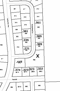
Figure 1. Areas of properties near 408 Homestead.
This area has restrictive covenants which require increased setbacks. One of the neighbor’s concerns was that the lots would not be wide enough to allow these setbacks to be provided. The book and page number of the covenants will be noted on the face of the plat and will apply to the newly created lots. In the RS-1 District the front yard setback is 25’. At this point, the lot width at the front building line must be a minimum of 70’. The RS-1 District has a side yard setback of 10’; however, the covenants require a side setback of 15’. The rear yard setback, when abutting a rear yard, must be at least 30’. Figure 2 shows the building envelope, the area available for construction of a structure, when the setbacks have been met.
At the southern portion of the property is a 10’ utility/pedestrian easement which was dedicated on the original plat. I am providing Figure 3 with the lot configuration as originally platted in 1962 for comparison with the proposed lot configuration.